
The Front Range finally saw its first real snow of the season last week, with Boulder picking up about 8 inches and the Foothills a bit more. The Mountains then cashed in over the weekend, stacking up one to four feet of powder. While this moisture is a welcome boost to our lagging snowpack, it’s not enough to erase drought concerns—but fire risk this year looks very different than the setup before the Marshall Fire. Looking ahead, the story shifts from snow to wind: multiple high‑wind events are on tap for the Foothills this week, while Boulder and Denver stay mostly dry and mild with highs in the 50s to 60s with occasional breeziness. Read on for the full breakdown of this week’s weather.
This week’s highlights include:
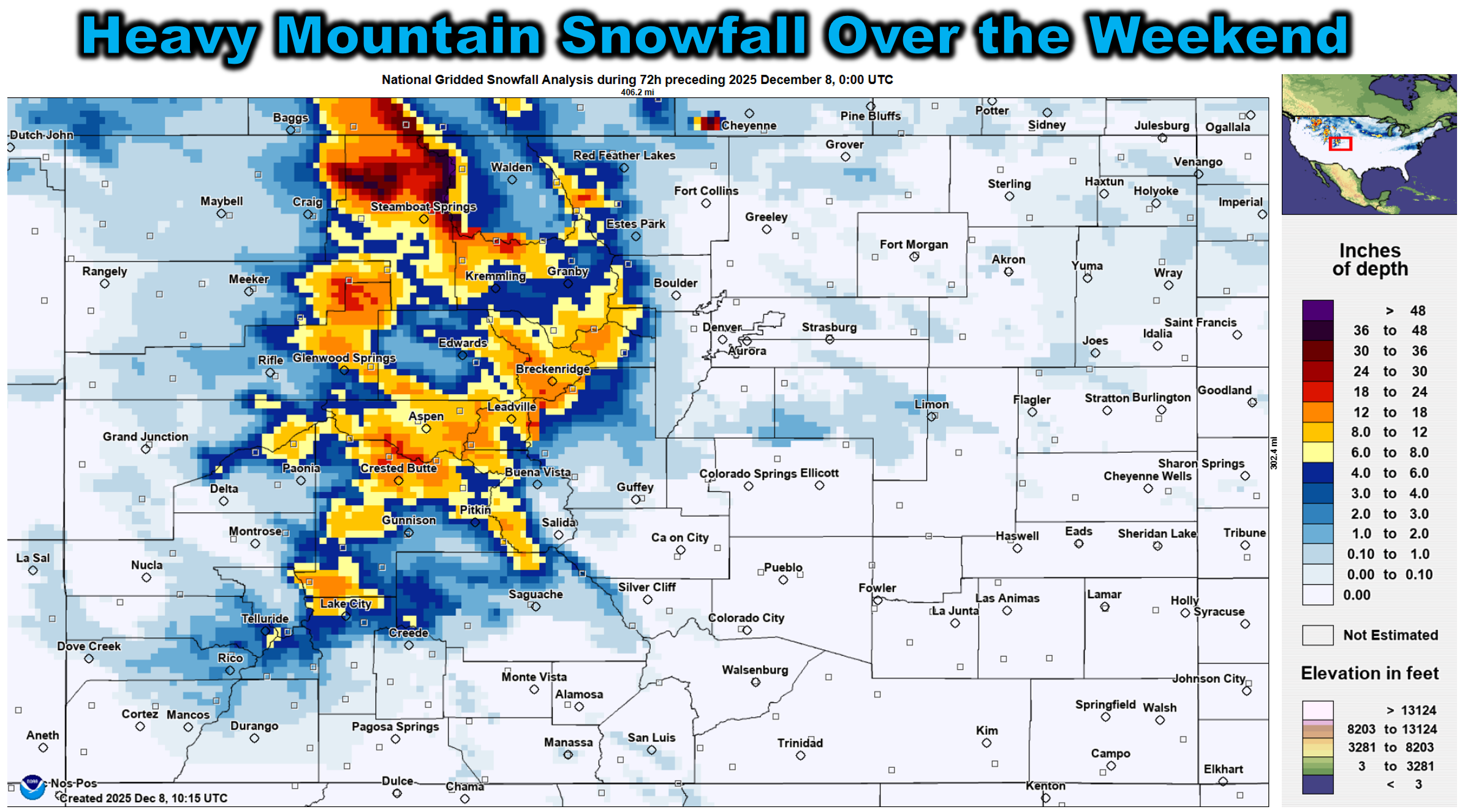
- 🏔️ Mountain dump: Over the weekend, northwest flow delivered 1–2 feet of snow in Mountains along I‑70, with up to 4 feet near Steamboat.
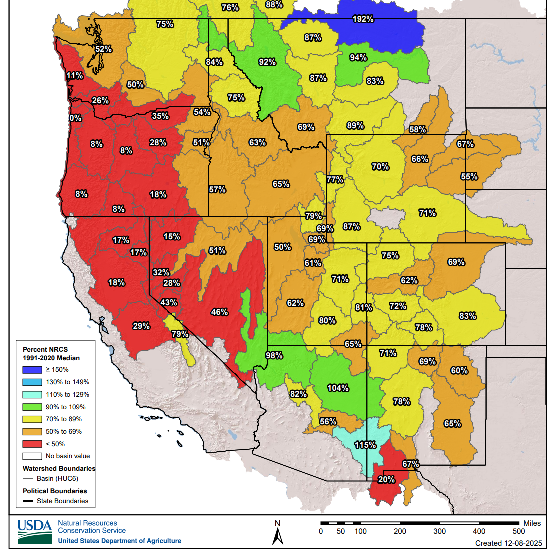
- 💧 Moisture boost: Statewide snowpack now sits at 62–83% of median—still below normal, but much better than Thanksgiving.
- 🔥 Fire risk context: Current drought isn’t nearly as severe as 2021 before the Marshall Fire; conditions this year don’t line up for a repeat “perfect storm.”
- 🌬️ Windy week ahead: Strong northwest flow will drive one or two high‑wind events in the Foothills this week, with the first event locked in for late Monday night into Tuesday (75 to 90 MPH gusts). The lower elevations will likely dodge the worst of the wind this week, but there is some uncertainty.
- 🌡️ Mild temps: Boulder and Denver stay mostly dry and warm this week, with highs in the 50s and 60s; only a modest cool‑down is coming for Friday.
- 🗓️ Repeat setup next week: Early signs point to more of the same mild, dry and windy weather continuing into next week or longer, with the odds for a white Christmas looking slim.
DISCLAIMER: This weekly outlook forecast is created Monday morning and covers the entire upcoming week. Accuracy will decrease as the week progresses as this post is NOT updated. To receive daily updated forecasts from our team, among many other perks, subscribe to BoulderCAST Premium.

Go Premium, get all the perks.
Daily Forecast Updates
Get our daily forecast discussion every morning delivered to your inbox.
All Our Model Data
Access to all our Colorado-centric high-resolution weather model graphics. Seriously — every one!
Ski & Hiking Forecasts
6-day forecasts for all the Colorado ski resorts, plus more than 120 hiking trails, including every 14er.
Smoke Forecasts
Wildfire smoke concentration predictions up to 72 hours into the future.
Exclusive Content
Weekend outlooks every Thursday, bonus storm updates, historical data and much more!
No Advertisements
Enjoy ad-free viewing on the entire site.
Recent snows, both high and low, plus some perspective on fire risk
Last week finally brought the Front Range its first widespread, measurable snowfall of the season. A slow-moving upslope storm dropped up to 9 inches in Boulder and as much as 11 inches in the nearby Foothills. After nearly two months of bone-dry weather, this storm was a welcome shot of moisture.
The Mountains didn’t see much from that system, but this past weekend was a different story. Several pulses of Pacific moisture riding the northwest flow slammed into the terrain, piling up 1 to 2 feet of snow along and north of I‑70. The Park Range near Steamboat even picked up close to 4 feet. Meanwhile, Boulder and Denver enjoyed a quiet weekend.
Between the Metro-area snow midweek and the Mountain dump over the weekend, the Front Range has banked a decent amount of moisture in just the last five days. Is it enough to erase drought or restore Mountain snowpack to normal? Not quite—but it’s progress. Statewide snowpack now sits between 62% and 83% of median, which isn’t great, but it’s a big improvement from the near record lows levels around Thanksgiving.
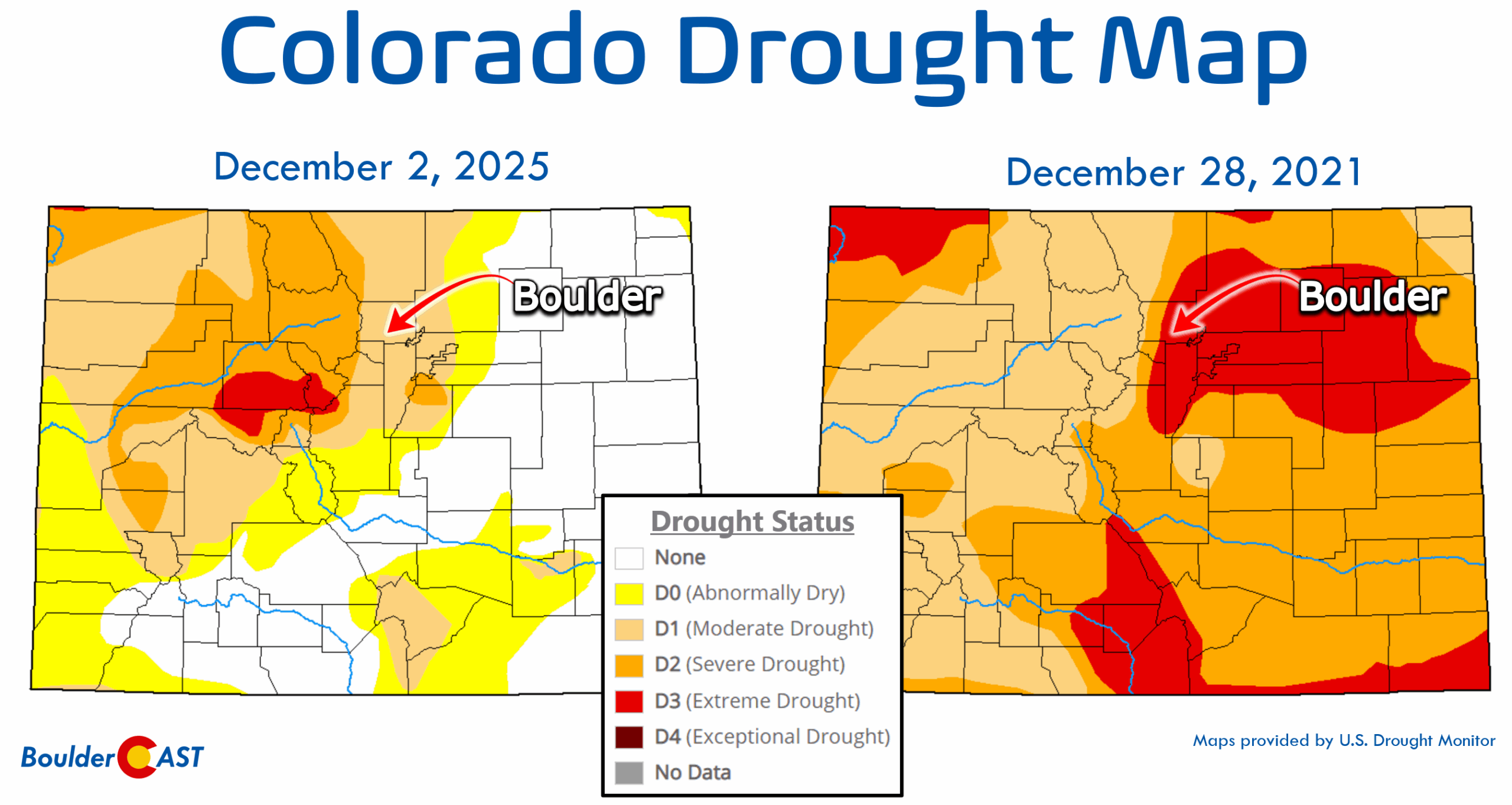
There’s been chatter comparing this autumn to 2021 before the Marshall Fire. Let’s clear that up. Colorado is naturally dry and windy this time of year, and grassy fuels are often primed to burn regardless of drought status. Drought plays a bigger role in forest fires at higher elevations, where evergreen fuels respond directly to long‑term moisture deficits. In the prairie‑urban interface, like eastern Boulder County, fire risk is more about fuel continuity and specific wind events than drought alone.
Let’s be clear, the Marshall Fire was a “perfect storm” scenario, one that would be extremely difficult to repeat even if conditions were identical.
- Fuel availability: A historically wet spring left behind abundant, tall grasses across Boulder County. By late fall, those grasses had dried into a tinderbox. The lack of any significant snow left these grasses fully free standing.
- Extreme drought: The summer and fall leading up to December were among the driest on record. Fuels were not just dry — they were desiccated, primed to ignite instantly.
- Historic wind event: Gusts of 100+ MPH roared down the Foothills into Rocky Flats and far south Boulder, one of the strongest downslope windstorms in two decades. These winds didn’t just spread flames; they hurled embers miles ahead, igniting spot fires deep into neighborhoods.
- Ignition timing and location: Multiple ignition points occurred in the absolute worst possible place — the wildland‑urban interface where prairie fuels meet dense suburban development, and at the worst time during the peak of the extreme windstorm.
Put together, these factors created a firestorm that overwhelmed suppression efforts and devastated communities in a matter of hours.
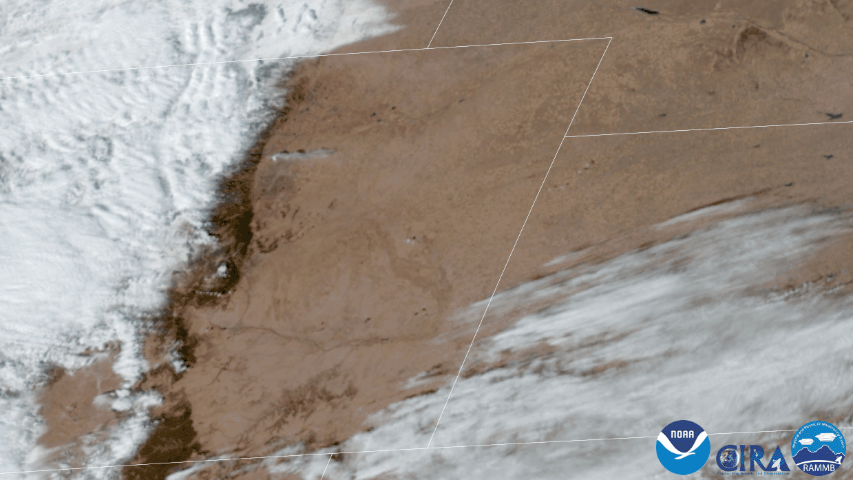
Satellite view from GOES-East of the Marshall Fire burning on December 30, 2021
2025 is a completely different story. This year’s spring was not abnormally wet, so we don’t have the same surplus of cured grass fuels. Summer rainfall, while not spectacular, was fairly typical, leaving fuels closer to seasonal norms. Current drought intensity across the Front Range is moderate, not extreme, and nowhere near the severity of late 2021. Plus utilities like Xcel are now quicker to proactively de‑energize power lines during high wind events, reducing one ignition source. While strong windstorms are always possible, the odds of another “one‑in‑twenty‑year” wind event aligning with ignition in the most vulnerable areas is low. While vigilance is always necessary, the current setup does not mirror the catastrophic alignment of conditions that produced the Marshall Fire.
The takeaway: We are never “safe” from fire in Colorado — it’s part of our landscape. But the specific combination of abundant cured fuels, extreme drought, and historic winds that drove the Marshall Fire is not present this year. That doesn’t mean we let our guard down, but it does mean the risk profile is different. Preparedness should remain steady, as always here in the Front Range, but not be heightened by misleading comparisons or inaccurate information spread by doomsayers.
View of Boulder just weeks before the Marshall Fire in early December 2021
Looking ahead: More wind than snow this week
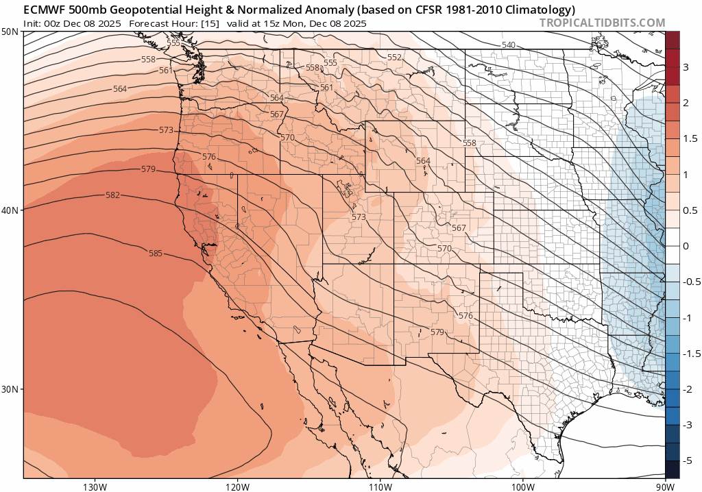
Unfortunately Colorado’s recent snowy bout is not set to continue this week, with more wind than snow expected for the Mountains and lower elevations alike. The broader atmospheric pattern for the first week of December will feature a stagnant setup of ridging along the West Coast with deep troughing into the Great Lakes. Colorado will stay between these two features, locked into a strong pressure gradient throughout most of the week, visible as the tightly-packed height lines in the Euro model’s 500mb height forecast animation below. This model view runs through Saturday. Note that there is barely any change over the next five to six days, with the Front Range remaining under brisk northwest flow the entire time.
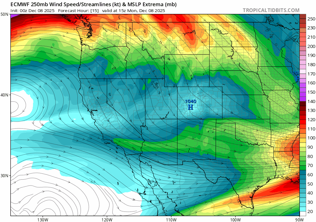
The polar jet stream will remain just off to our north and east through the week, meandering a bit, and at times, dipping into to northern Colorado. A combination of the nearby jet, tight pressure gradient, and occasional shortwaves passing to our north will fire off several rounds of high winds in the Front Range.
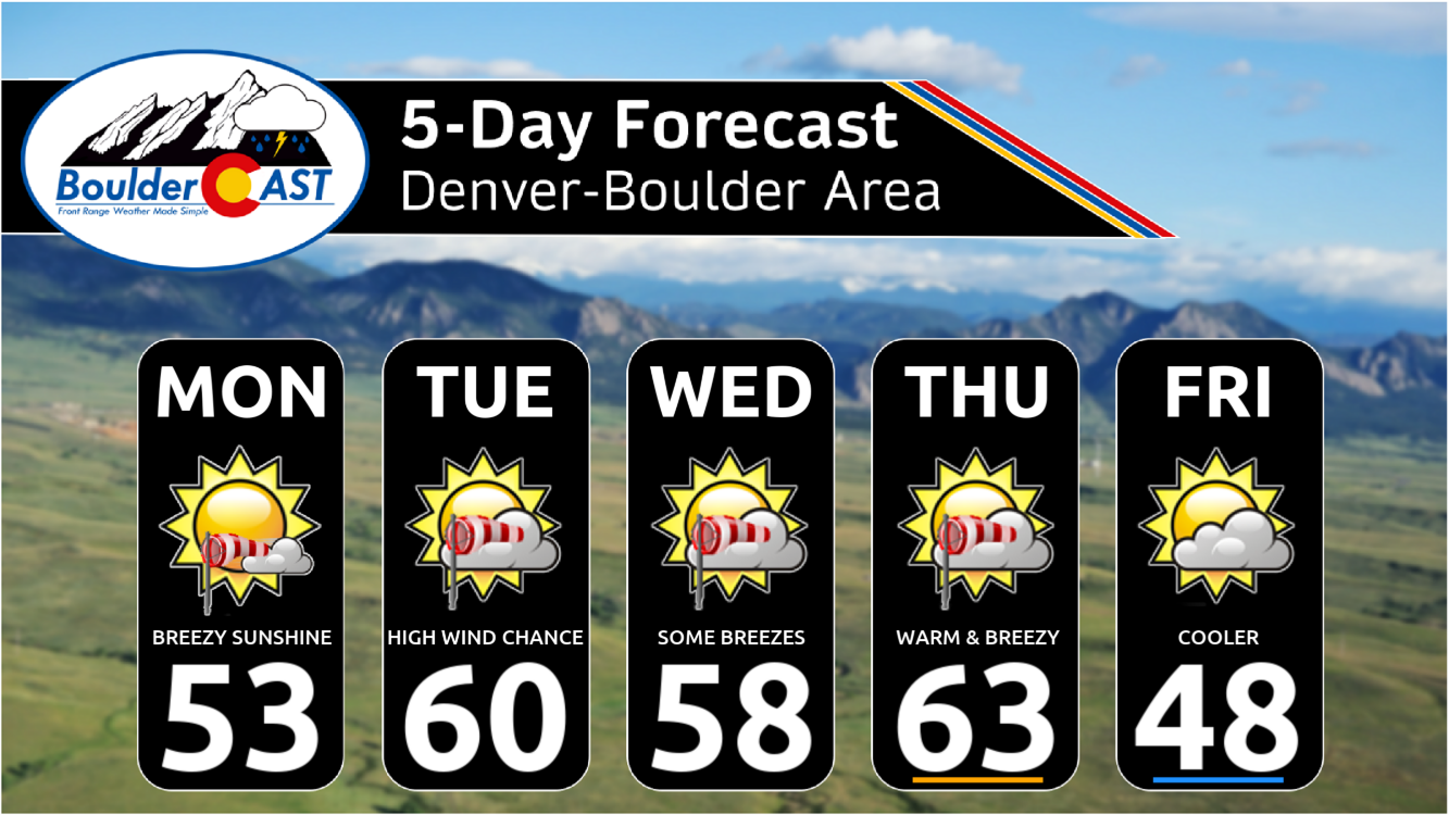
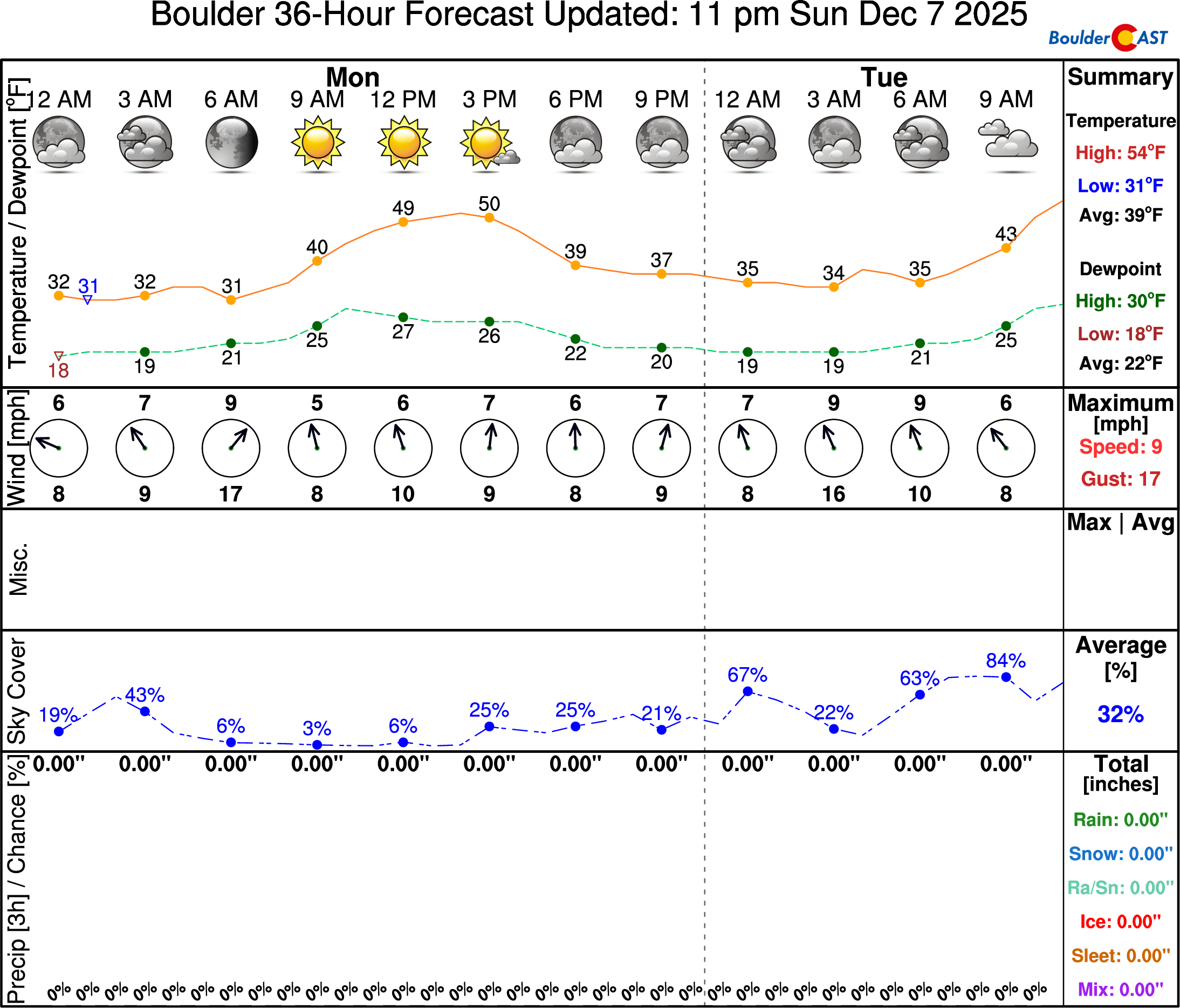
First up, though, is Monday which will be a beautiful day in the Front Range. Boulder and Denver should reach the lower 50s with mostly sunny skies and generally light winds, though with intermittent breeziness in spots.
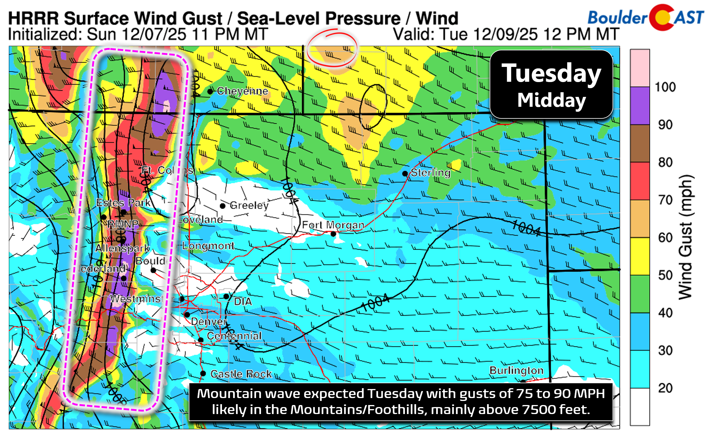
The first high wind event of the week will begin in the Foothills Monday night, peaking during the day on Tuesday as a mountain wave forces very strong cross-barrier winds to cascade down the eastern slopes of the Rockies. Gusts of 70 to 90 MPH are likely on Tuesday above ~7000 feet elevation, with some gusts approaching 100 MPH not out of the question, as indicated by the HRRR model solution for midday Tuesday below.
Fortunately it looks like the immediate Boulder/Denver area will dodge this downslope windstorm, with unfavorable conditions for these extreme winds to come down into town on a broad scale. There still could be some stronger gusts working into wind prone areas from Boulder to Broomfield to Rocky Flats to Golden. It’s not clear at this time what magnitude of winds will make it into Boulder proper.
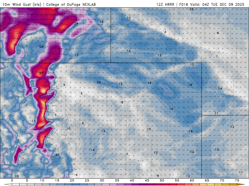
HRRR wind gust forecast for Tuesday showing the extreme winds expected in the Foothills
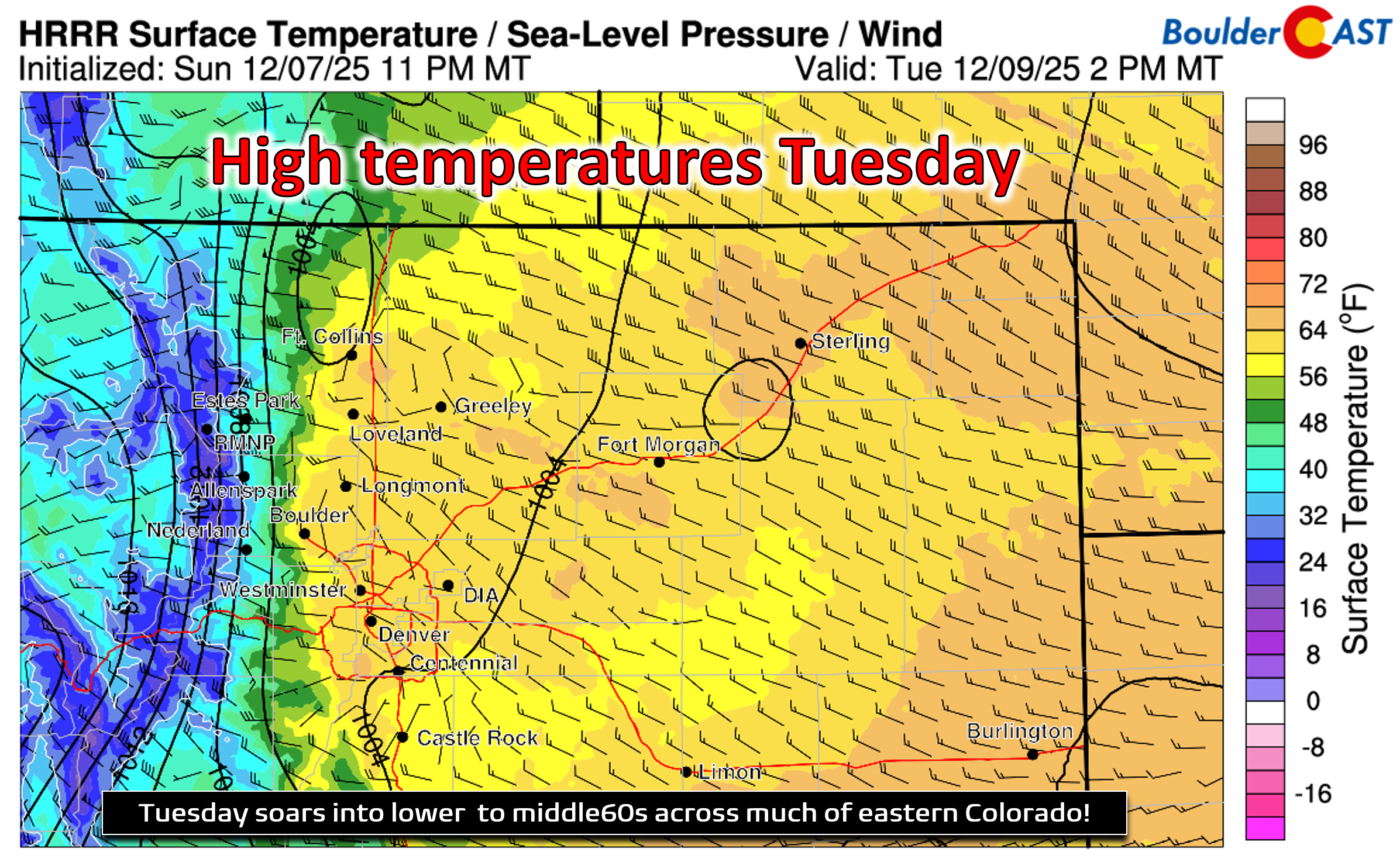
Instead, the little bit of wind we get will lead to friendly compressional warming, with high temperatures Tuesday favored to reach close to 60 degrees, eating away at whatever snow-cover still remains by then.
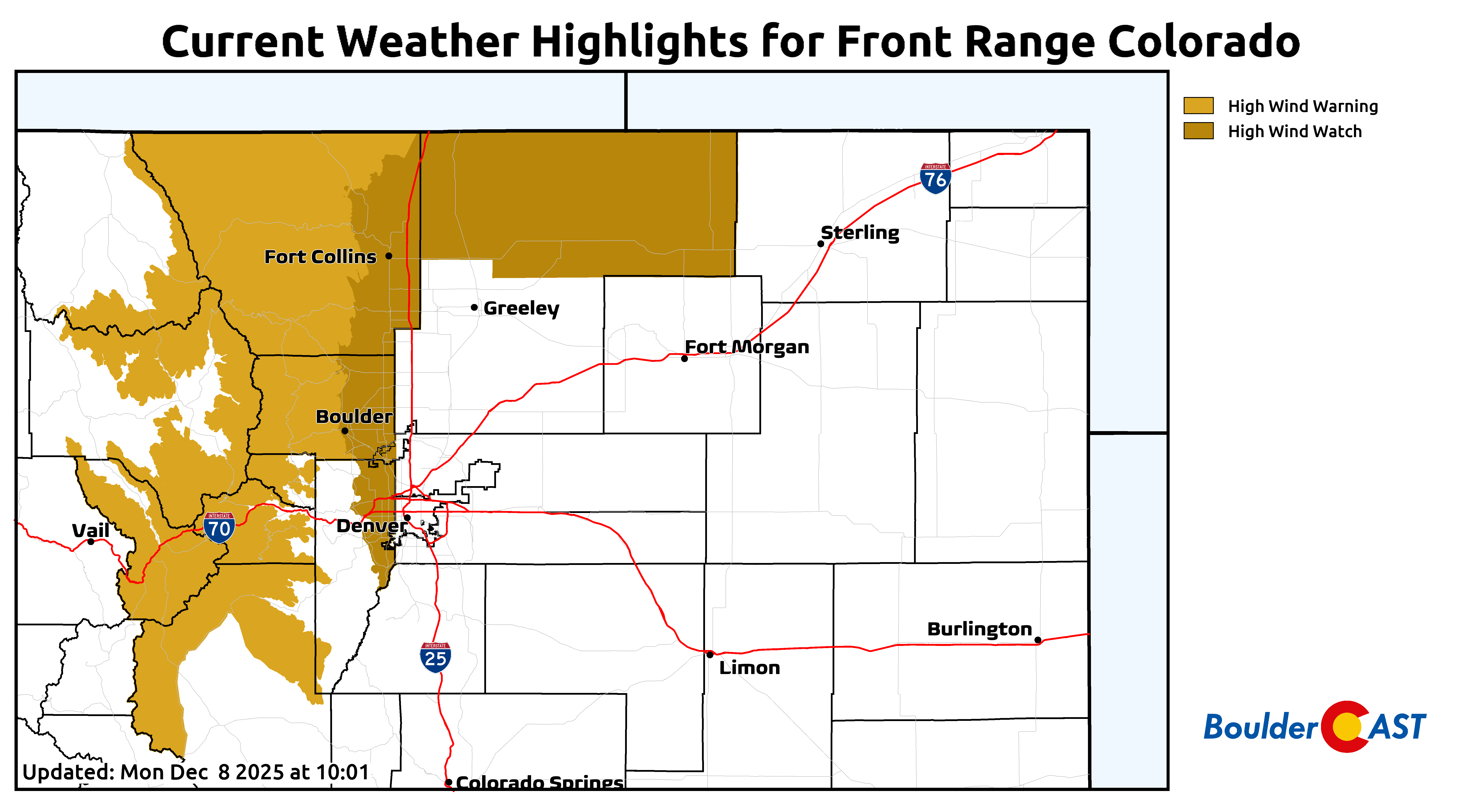
A High Wind Warning is currently posted for late Monday night through Tuesday evening for the Mountains and Foothills. These communities should plan for the worst with what will be the first significant wind event of the season. Secure outdoor furniture and items and prep for some power outages from downed trees. It’s possible that Xcel shuts off the grid in the Foothills for this event, but the recent snow will thankfully keep the risk for fires down in the windiest areas, thus making any action from Xcel unlikely in our opinion. What happens across the lower elevations immediately adjacent to the Foothills remains unclear regarding whether the very strong winds will spill down this far. It’s possible, but not guaranteed just yet. Models mostly show that damaging wind gusts would be more isolated and sporadic down here, including in Boulder. High Wind Watches are currently posted for these far western suburbs near the Foothills from Fort Collins to Boulder to Golden.
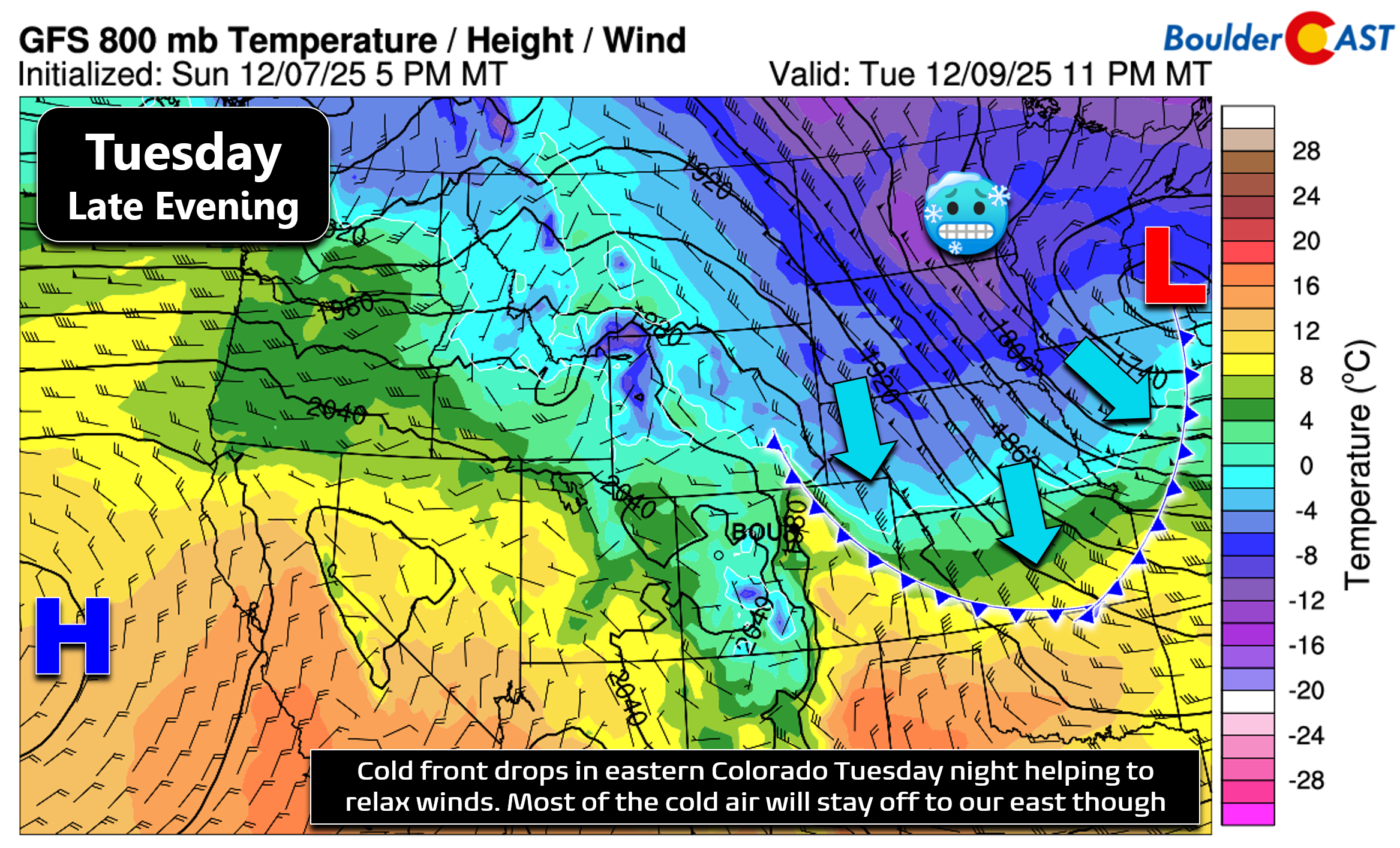
Winds should finally relax in the Foothills Tuesday evening as a cold front drops across eastern Colorado, helping to relax the pressure gradient and stabilize the lower atmosphere. This front is tied to a low pressure all the way off in the Great Lakes, with only the tail-end of the front reaching our area. Thus we’re not expecting any upslope behind the front, and the cooling we see will be minor with the coldest air staying well east. Expect high temperatures to cool only slightly for Wednesday into the mid to upper 50s.
Another shortwave disturbance in the northwest flow will dip into the Upper Midwest around midweek, with the jet stream once again wobbling southward into northern Colorado. While not certain, it appears possible that another high wind event may unfold across the Foothills beginning something Wednesday lasting into Thursday, with at least some breeziness spilling into the nearby Plains. Models have been trending this system a bit further north and east, taking any chance of precipitation for Boulder and Denver this week with it, now only having light Mountain snow and the wind risk left in the forecast. Despite the uncertainty, Thursday should be the warmest day of the week with highs in the low to middle 60s and a chance of some breeziness.
By the end of the week, a strong Arctic frontal boundary will be working south across the center of the nation, bringing extreme cold to portions of the Great Plains, Great Lakes and East Coast. We’ve seen the forecast models shift on this aspect of the extended forecast as well. While a few days ago it looked like this Arctic blast may reach Colorado late in the week, that’s no longer is the case, with nearly every model solution keeping the frigid air east of the Front Range. As long as models don’t trend it any further away, we’re still likely to see at least a moderate cold front move through Thursday night or early Friday, with cooler temperatures to end the week. Highs should land between 40 and 55°F for Friday with light winds and partly sunny skies. Yes, that’s a big range, but that’s where we are right now.
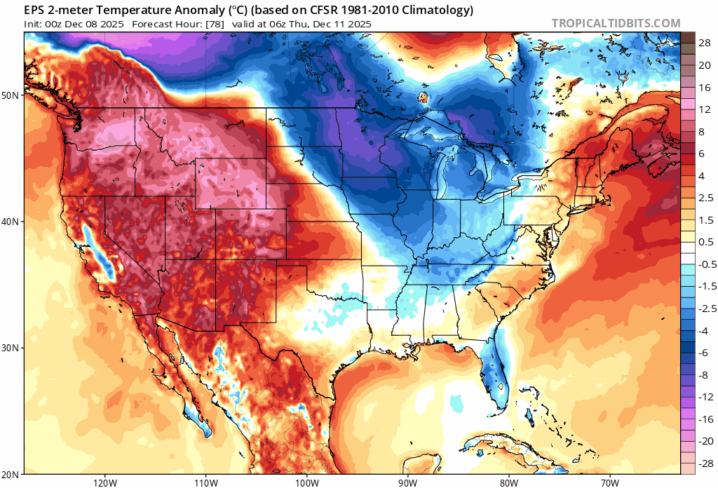
Surface temperature anomaly forecast from the Euro ensemble for late week into the weekend as the cold air misses Colorado to the east
In summary, it’ll be a dry, breezy week with temperatures at or above normal through the extended for Boulder and Denver. The Foothills and Mountains will have to endure at least one or maybe two rounds of damaging winds. The jury is still out for lower elevation wind risk, but keep an eye on Tuesday and Thursday.
Between the various waves clipping northern Colorado this week, the northern Mountains will pick up some light snow but not much (1 to 6″ totals). Steamboat should do a tad better, with a cumulative 6 to 12″ there by the weekend.
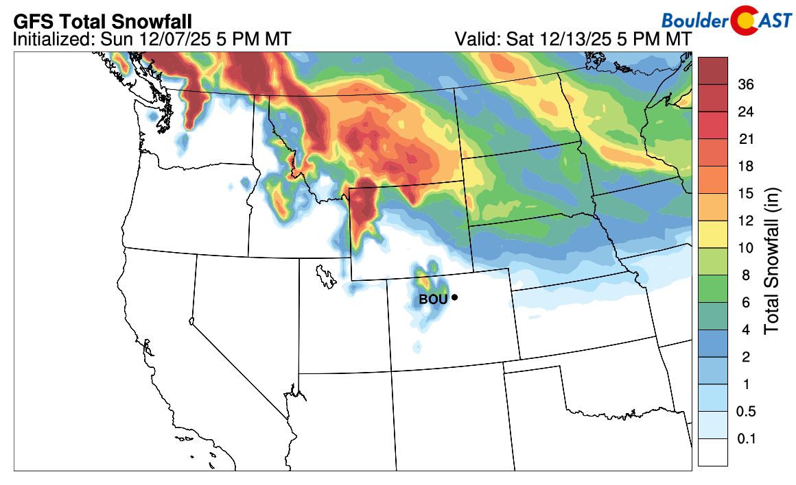
GFS model derived snowfall forecast through the week. Most of the action stays well northeast of the Front Range, with just some light mountain snow expected in the northern High Country
Early signs point to next week being almost identical to this one, with the same large scale pattern holding strong across the nation — a ridge along the West Coast, a trough in the East, and Colorado under brisk northwest flow staying warm and dry with occasional blasts of wind. While not impossible, the odds for significant accumulating snow between now and Christmas are fairly low. We won’t fully rule out a white Christmas quite yet, though. Stay tuned on that front. Happy Monday!
Forecast Specifics:
Monday: Mostly sunny and mild with highs in the lower 50s on the Plains and lower 40s in the Foothills. Some breezes of 10 to 20 MPH possible.
Tuesday: Partly cloudy, breezy and warm with highs near 60 on the Plains with upper 40s in the Foothills. Very strong downslope winds are expected above 7000 feet with gusts of 75 to 85 MPH common, and a few gusts over 100 MPH possible. Winds will lessen by the late evening. A few damaging gusts could occur in Boulder and other western suburbs, but this is uncertain still.
Wednesday: Patchy wave clouds, mild and breezy. Highs in the upper 50s on the Plains with middle 40s in the Foothills.
Thursday: Partly cloudy, warm and possibly breezy. Temperatures soar into the low to middle 60s across the lower elevations and into the lower 50s in the Foothills.
Friday: Cooler behind a cold front with highs likely between 45 and 50°F. Highs in the upper 30s to mid 40s in the Foothills.
Weekend: Staying mild and dry with a mix of clouds and sun. Highs likely return to the 50s or possible low 60s.
DISCLAIMER: This weekly outlook forecast is created Monday morning and covers the entire upcoming week. Accuracy will decrease as the week progresses as this post is NOT updated. To receive daily updated forecasts from our team, among many other perks, subscribe to BoulderCAST Premium.
Go Premium, get all the perks.
Daily Forecast Updates
Get our daily forecast discussion every morning delivered to your inbox.
All Our Model Data
Access to all our Colorado-centric high-resolution weather model graphics. Seriously — every one!
Ski & Hiking Forecasts
6-day forecasts for all the Colorado ski resorts, plus more than 120 hiking trails, including every 14er.
Smoke Forecasts
Wildfire smoke concentration predictions up to 72 hours into the future.
Exclusive Content
Weekend outlooks every Thursday, bonus storm updates, historical data and much more!
No Advertisements
Enjoy ad-free viewing on the entire site.
Enjoy our content? Give it a share!


You must be logged in to post a comment.