⦁❶⦁ Falling and blowing snow will continue at various intensities in the Mountains through the rest of the week causing travel impacts
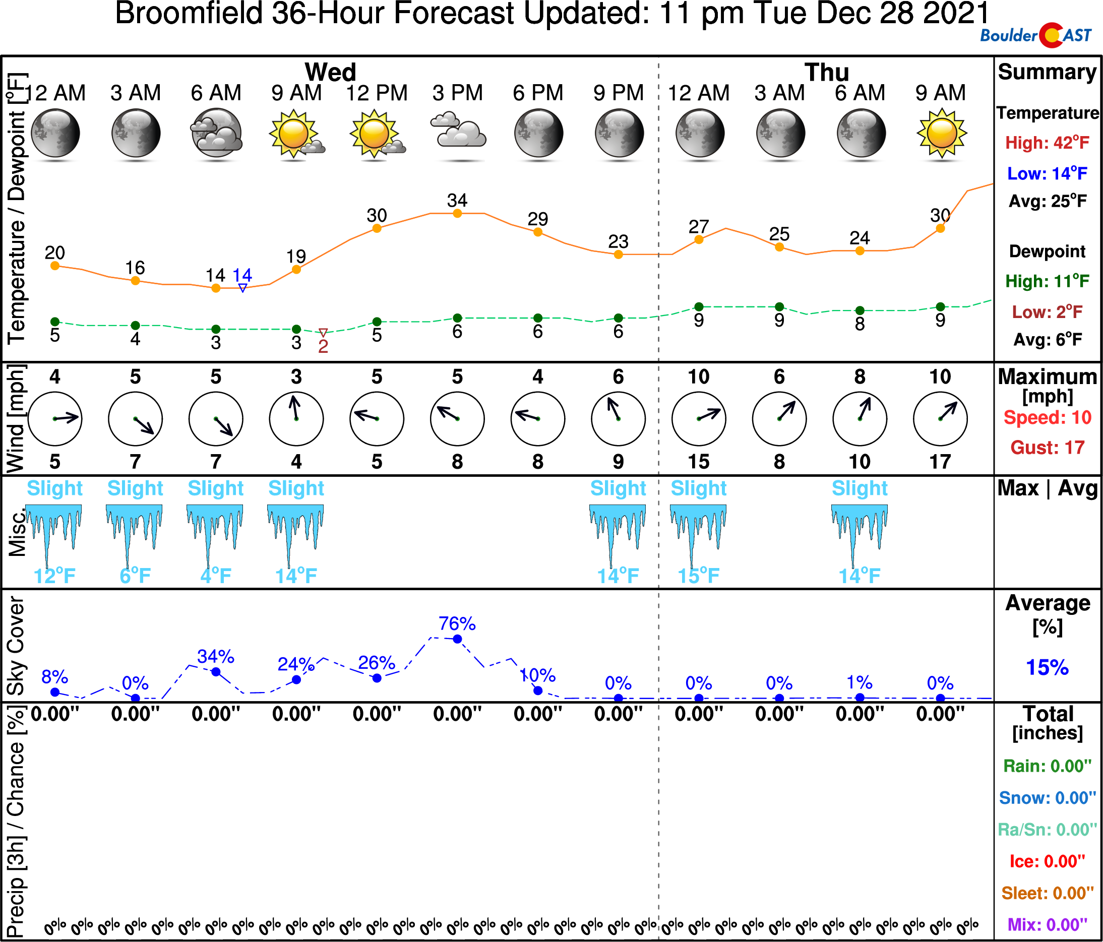
⦁❷⦁ Very quiet today across the Denver Metro area with highs in the 30’s under partly cloudy skies
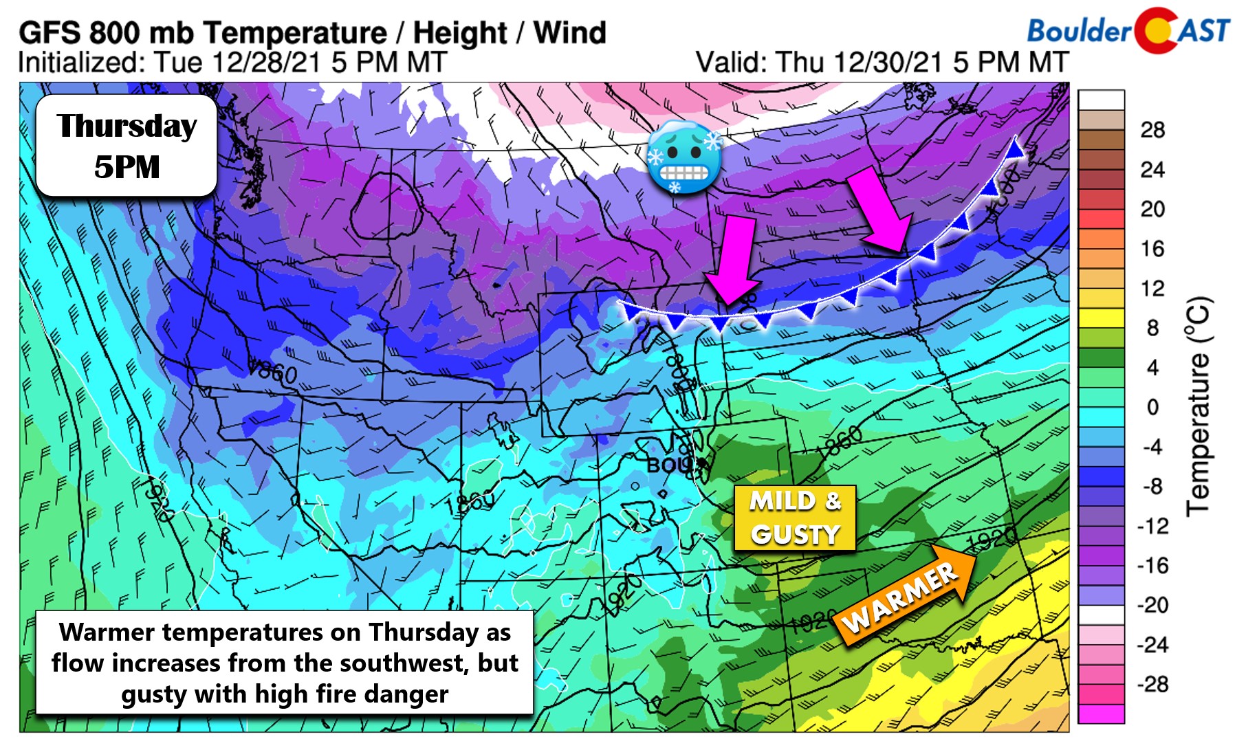
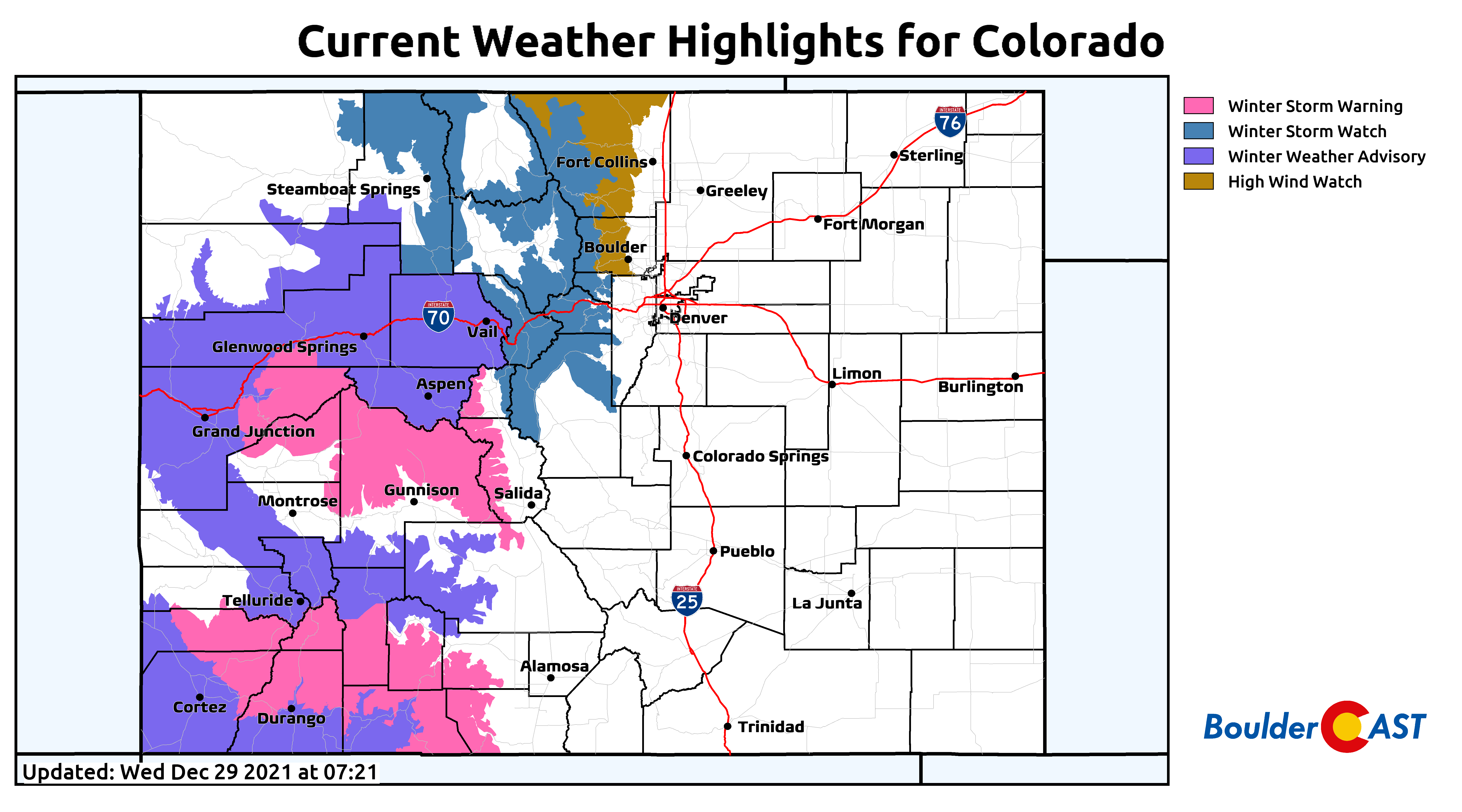
⦁❸⦁ Warmer tomorrow, but high winds are possible in and near the Foothills — this will create elevated fire danger
⦁❹⦁ New Year’s Eve snowfall is all but guaranteed (woo!), but models still disagree on how much snow will fall
Do you want the latest BoulderCAST Daily forecast discussion delivered to your inbox every single morning? If so, join BoulderCAST Premium where we talk Boulder and Denver weather every single day.

Detailed Forecast Discussion:
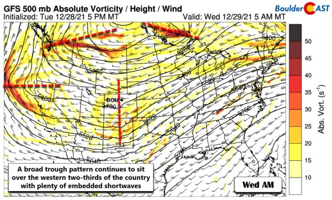
Abroad trough remains the story across the western two-thirds of the country today. Within this larger trough signature, at least four shortwave disturbances are noted and highlighted below in red. This type of setup has been very typical this season for the West and is part of the problem for why we’ve so little snow thus far in the Front Range. Instead of organizing into a major storm system and moving through, troughs have tended to stall just like this with a bunch of smaller storms spinning up instead. These smaller systems move rapidly and have weaker forcings — most importantly they dont get much upslope going east of the Mountains which is critical for snow in the Denver area.
In any case, there is a small shortwave passing overhead this morning. This wave helped keep light snowfall going in the Mountains overnight. With the axis passing, we should see minor subsidence on the backside and snowfall will temporarily wane in the High Country through the day, but never completely stop under continued mildly favorable orographics. It will also be blustery up there creating difficult travel due to blowing snow and falling snow in spots. Be careful on any of the Mountain passes through the rest of the week!
Across the lower elevations, today will be rather quiet but chilly with highs in the 30’s and partly cloudy skies. We are starting out cold in the lower teens, but things should warm up fairly quickly with the sunshine taking hold.
Tomorrow will be warmer as flow turns southwesterly and increases in strength ahead of the primary trough axis coming in for New Year’s Eve. This will downslope eastern Colorado and bump up the fire danger across the Front Range.
Models are also beginning to zero-in on a high wind event Thursday afternoon with minor mountain wave enhancement noted. It’s not an ideal setup with southwest flow, so this won’t be that strong. Nonetheless, winds should ramp up mid to late Thursday morning and be windy through Thursday late afternoon or early evening. Winds around Boulder could gust to 55 MPH with even stronger gusts in the Foothills. Gusts up to 40 MPH are possible in Denver. Thankfully, humidities will rise tomorrow to about 20% meaning fire danger won’t be absolutely critical. However, everything is so dry it’s still a dangerous fire weather day! Moisture will be lower southeast of Denver towards Limon where Red Flag Warnings may be issued.
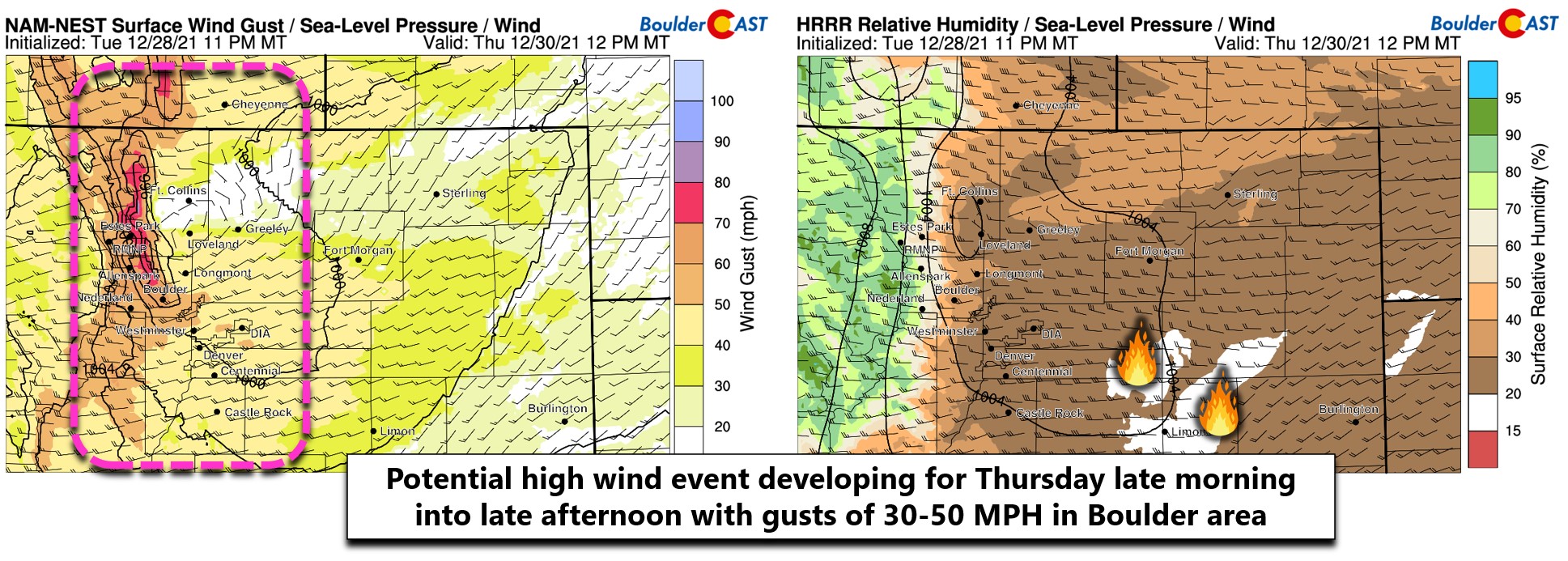
A High Wind Watch is currently in effect for the Boulder and Larimer County Foothills. It’s unclear if these will turn into Warnings or not since this wind event is so marginal.
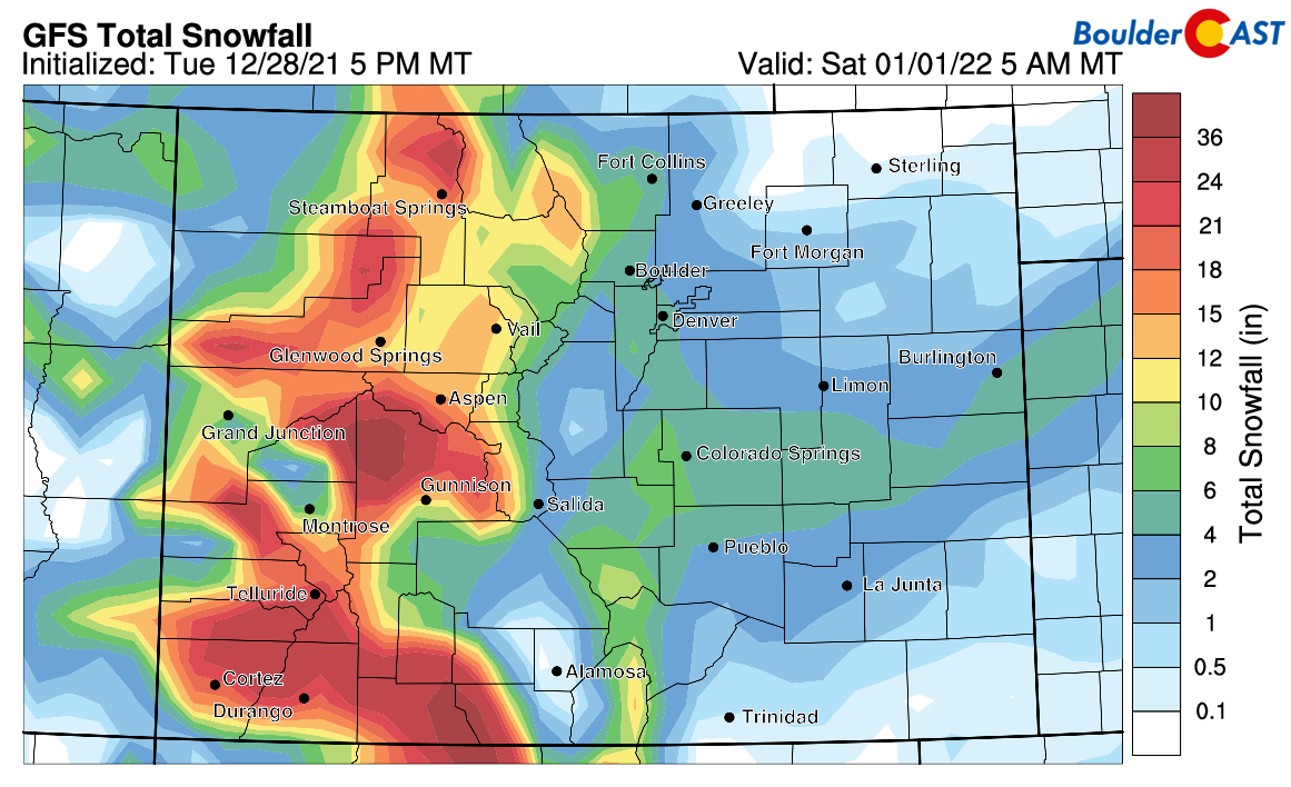
A cold and snowy shift is still in the works for Friday afternoon into the overnight. I feel the need to reiterate this fact daily since we’ve seen so many potential snow events fizzle out already this year. The general mindset among our readers is that any possible snowfall will never pan out. We’re here to confirm this one still looks excellent for light snow up and down the Front Range on New Year’s Eve alongside some of the coldest air of the season! The only real change in the models today is noting that the Euro is bringing a stronger and slower storm across Colorado compared to the other models resulting in bullish snowfall totals of 5-10″ for our area. The GFS and NAM remain convinced that this will be a brief light snow event with some potential jet-forced banded snow near the onset. The Euro has flopped almost every single storm this year so far, so don’t read too much into that bullish prediction just yet. We still think the GFS has the best handle on this storm right now — its latest snowfall forecast is shown below. Generally 1-5″ of fluffy snow is expected across the Denver Metro area, with the highest totals west and southwest of town. Snow could begin as early as Friday afternoon from Boulder to Fort Collins (watch out for the jet!), but the bulk of the upslope action comes Friday evening into the early morning hours Saturday as temperatures plummet into the teens and single digits.
Remember, our daily forecasts are Premium content. Periodically, we open this forecast up to all of our readers. Today is one of those days! Plus we have a year-end sale running. Just use promo code 2022 to save 30% through January 1st.
Help support our team of Front Range weather bloggers by joining BoulderCAST Premium. We talk Boulder and Denver weather every single day. Sign up now to get access to our daily forecast discussions each morning, complete six-day skiing and hiking forecasts powered by machine learning, first-class access to all our Colorado-centric high-resolution weather graphics, bonus storm updates and much more! Or not, we just appreciate your readership!


You must be logged in to post a comment.