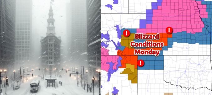
All is quiet on Sunday, but that will quickly change after midnight Sunday night! The third southern-track storm system in five days will take a more favorable track for the Front Range, leading to a period of snow and gusty winds in our area early Monday. While there is still some uncertainty in the exact outcome, we discuss the latest forecast including potential snow amounts and where blizzard conditions will unfold on Monday.
At a Glance
- A southern-track storm system will pass to the south of Colorado on Sunday night into Monday, bringing gusty winds, cold air, and snow to the Front Range.
- The storm will have a sharp northern edge, meaning areas north of Denver will see little to no snow, while areas south of Denver may see moderate to heavy snow.
- The storm will move out by Monday afternoon, leaving behind gusty winds and chilly temperatures with highs only in the 20s with wind chills in the single digits and teens.
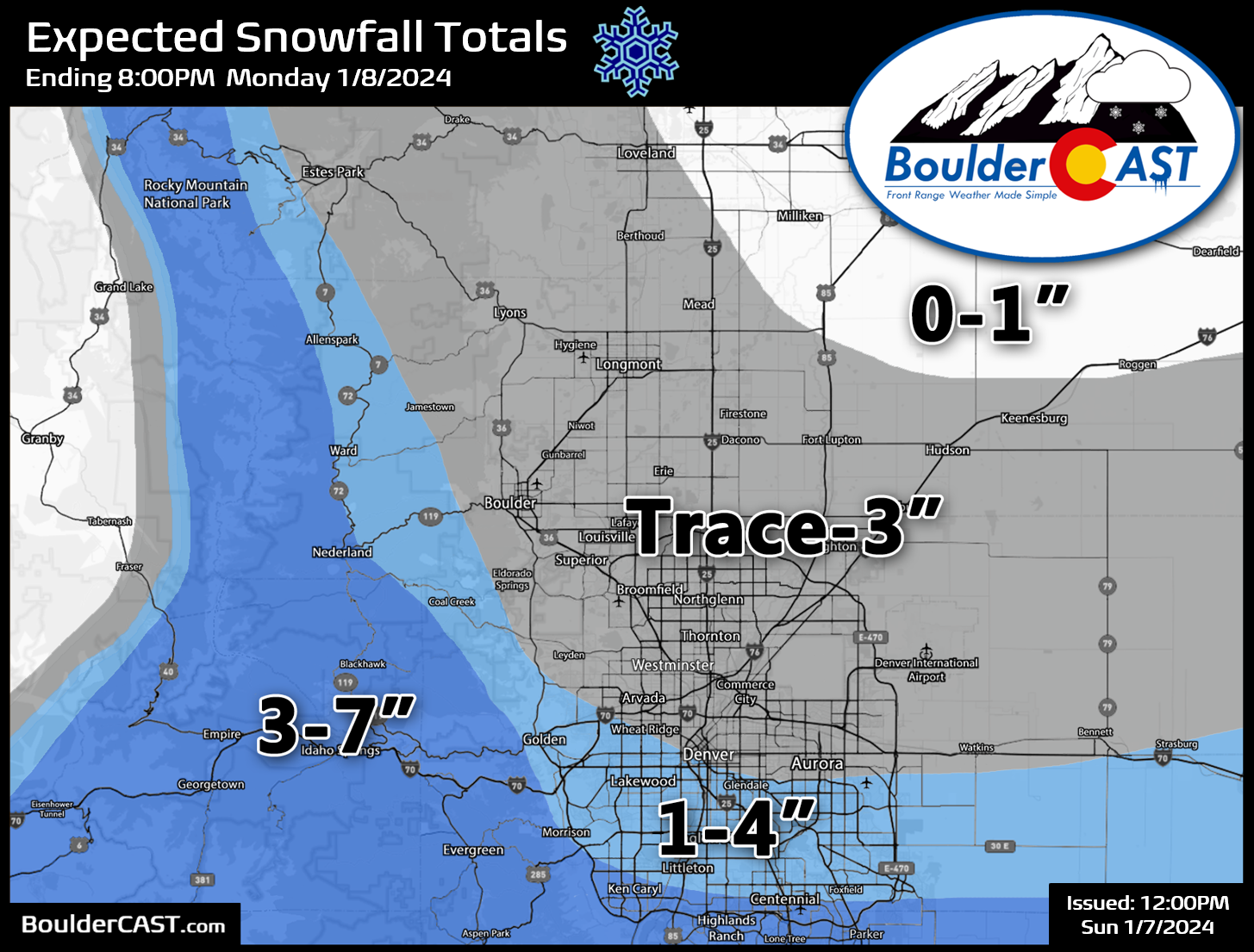
- The Boulder-Denver area is expected to see a trace to 4 inches of snow, with higher amounts possible south of the city. The Palmer Divide and southern Foothills could see 3-7 inches of snow, along with borderline blizzard conditions.
- Travel impacts are likely for the Monday morning commute, especially along and south of I-70
Our third southern-track storm in five days!
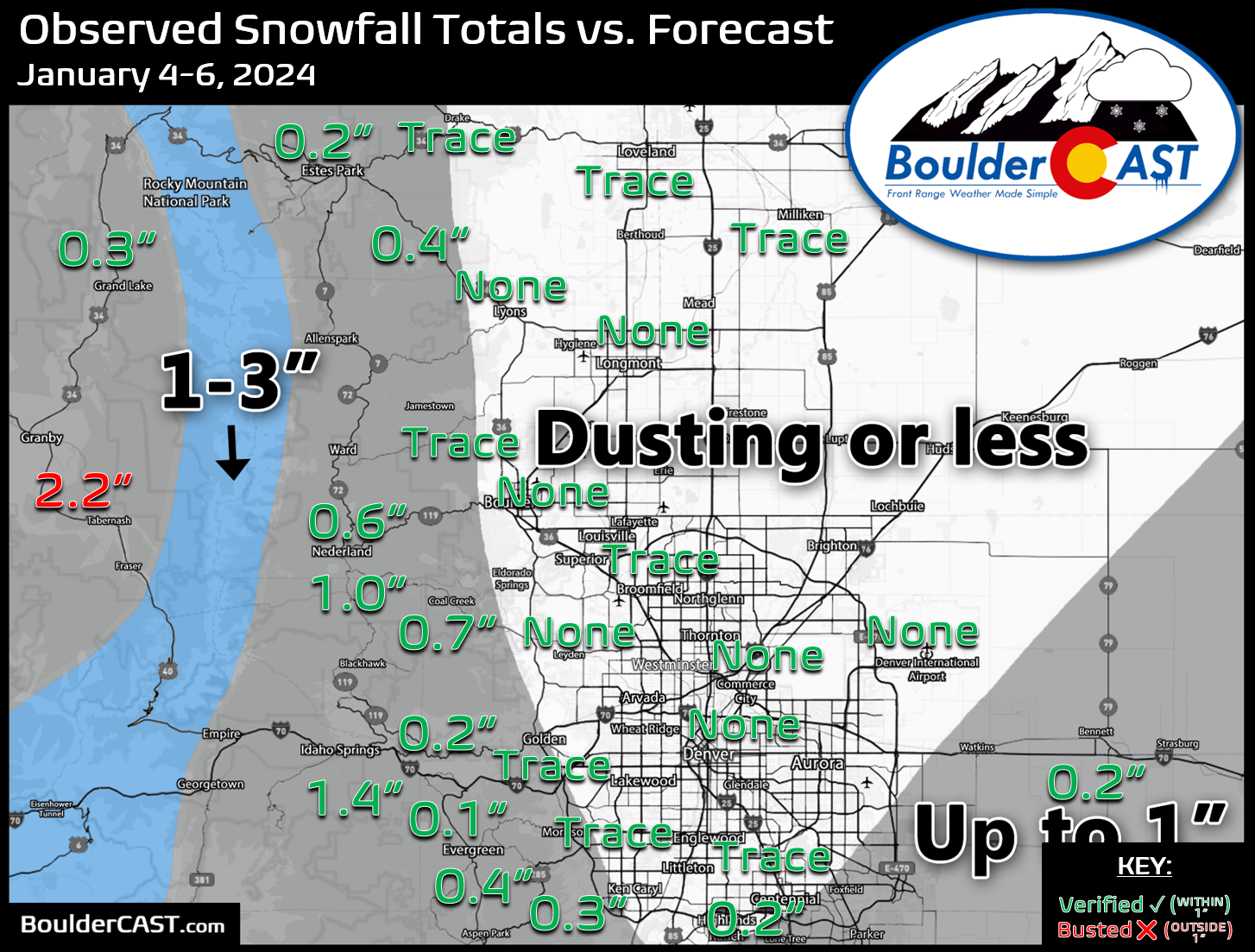
The southern-tier storm track has become increasingly active in recent times, but the last two storm systems riding along it — the initial one Thursday night and the follow-up one Friday night — produced very little snowfall across the Front Range. This meager snow outcome was expected since they tracked quite far south of our area, were somewhat small in footprint, and downslope flow largely killed off most of the hope for many snowflakes around Boulder especially. Three-day snowfall totals ranged from nothing to a dusting in most of the Denver Metro area, with up to 1-2″ in the higher terrain.
After two relatively quiet but chilly days this weekend, yet another southern-track storm is already knocking on our door off to the southwest — and we’re optimistic this one may be coming in a bit hot and overperform. As of Sunday around midday, the developing low pressure is located in far southwest Utah.

GOES-East water vapor imagery shows the faucet of moisture streaming into Colorado from the southwest ahead of the storm. This will lead to a mostly cloudy (but dry) day for our Sunday as the storm makes its approach.

Over the next 24 to 36 hours, this storm system will slide east becoming a veritable “Four Corners Low”. By Sunday night, it will break off into a closed low pressure along the Colorado-New Mexico border before arriving in the Oklahoma Panhandle by Monday afternoon.
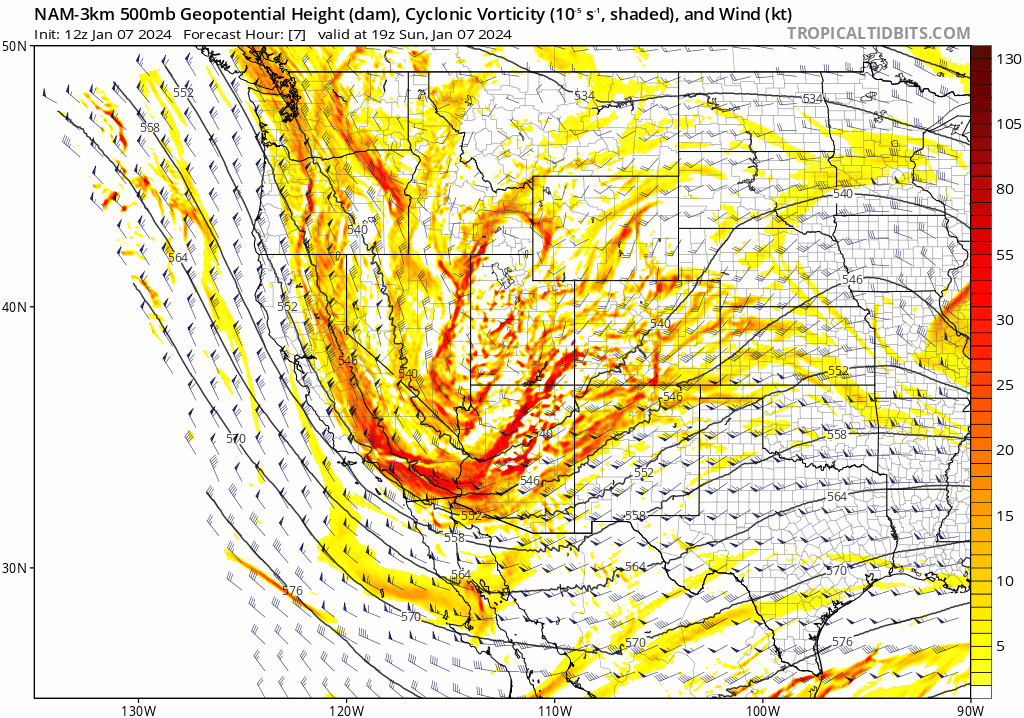
This track, while similar to the one taken by the recent storms, is notably further north by ~120 miles and that alone should lead to a better chance of snow across the Denver Metro area Sunday night into Monday morning. As the energy comes down from the Rockies, lee cyclogenesis will ensue with a formidable low pressure forming just across the border in northeastern New Mexico early Monday morning. This rapid intensification will really get the winds whipping across eastern Colorado early Monday with blizzard conditions likely across the farmy flatlands to the east and southeast.
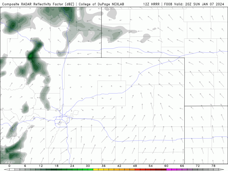
As the storm moves into position and intensifies late Sunday night, we expect an overlapping period of frontogenesis, moderate forcing from the passing through, and deep northeasterly upslope flow. This has increased our confidence in widespread snow developing across the Front Range late Sunday night into Monday morning. Some of the short-range models are even indicating moderate to heavy banding of snowfall right over the Denver area, as shown in the HRRR simulated radar animation below.
The threat of those heavier snowfall rates results in some impressive potential snowfall totals being forecast by the short-range suite — 2-7″ of the Metro area, highest on the south side.

There is generally good agreement for this heavier snowfall to occur among the short-range models. However, the global models are still not entirely onboard. The GFS has just a trace to 2″ across the Metro area from this event (below on left). The NAM has more like 1-4″ (below right). Most concerning though, the Euro (not shown) has basically a dusting or less for the entire area.

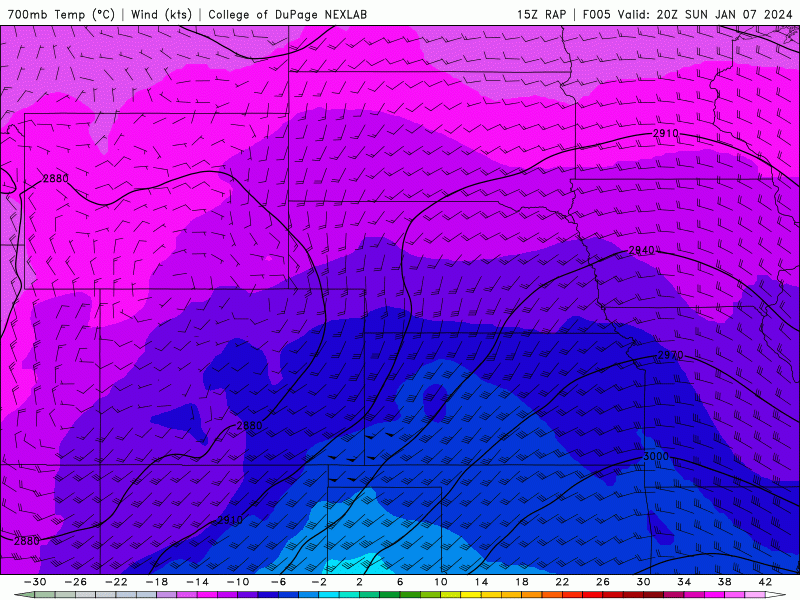
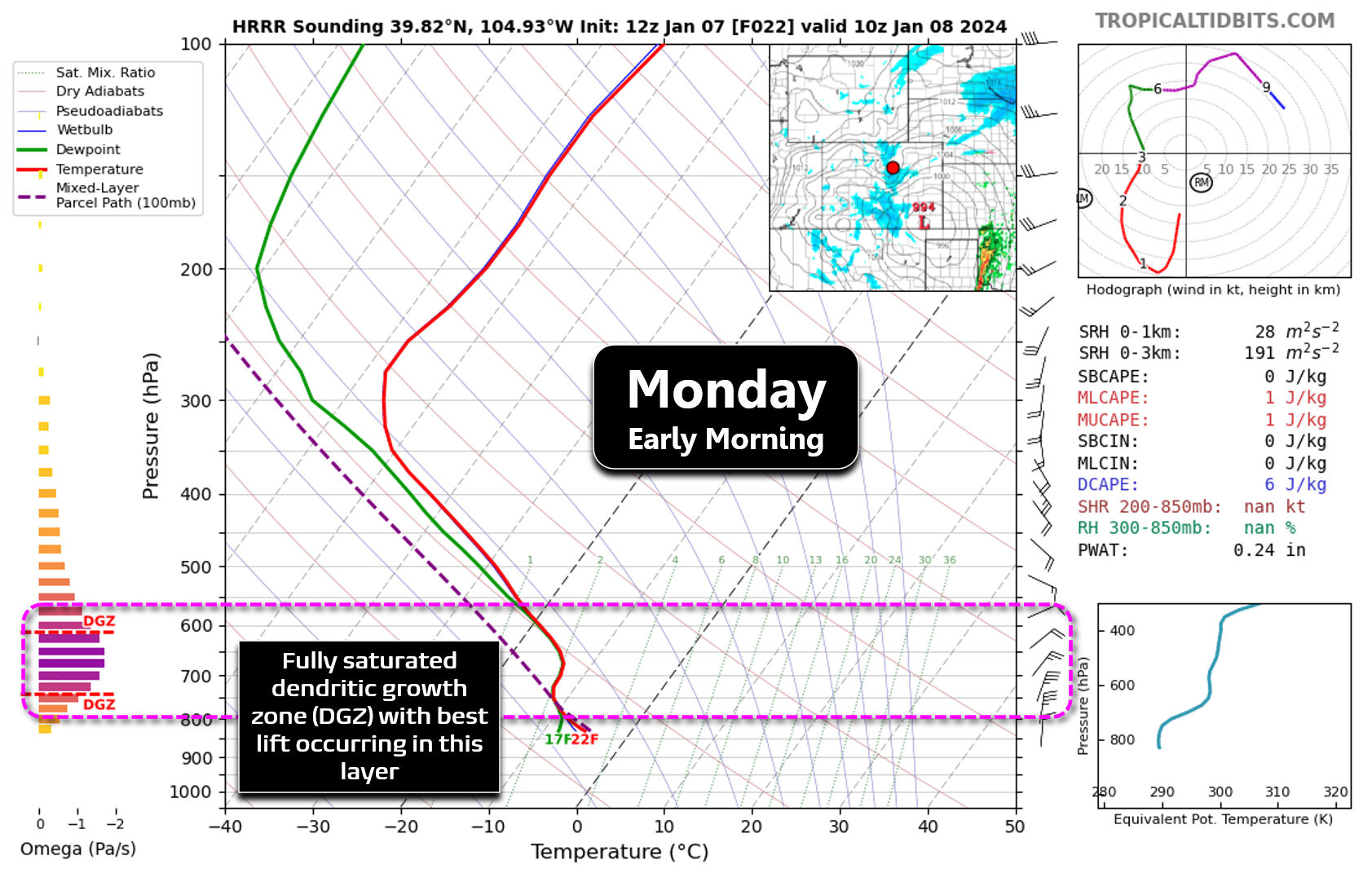
It’s definitely a mix bag of potential outcomes with this snowfall event, so confidence overall isn’t that great on exactly how much snow falls across the area. One thing this storm does have going for it is dendrites. Yes, early Monday morning as the best forcings come together, the temperature and moisture structure of the atmosphere aloft will be primed for big fluffy snow. Forecast soundings show a deep and saturated dendritic growth zone (DGZ) with lift maximized and also 20 MPH northeasterly upslope occurring in that layer. This is just a fancy way of saying snow growth should be very efficient early Monday which will help to bolster snowfall rates and ratios.
Snow won’t be the only concern across eastern Colorado on Monday morning. The intensifying low will also generate very strong winds leading to areas of drifting snow in the Metro area, with blizzard conditions all but confirmed for the Palmer Divide area and into the plains of southeast Colorado. Gusts of 55 to 75 MPH will be possible in portions of southeast Colorado on Monday with significant travel impacts expected there! Back in the Front Range, our gusts on Monday will be more in the range of 25 to 40 MPH during the morning and afternoon.

We could see some spotty snow showers or flurries begin Sunday evening, but most of the action will hold off until after midnight Sunday night, with snowfall coverage and intensity peaking in the morning hours Monday. Here’s the current NowCAST for Boulder showing the arrival of the snow after midnight and gusty winds. Depending on exactly how far northwest the snow bands set up early Monday, we could be looking at some morning commute impacts in Boulder due to slick roads.
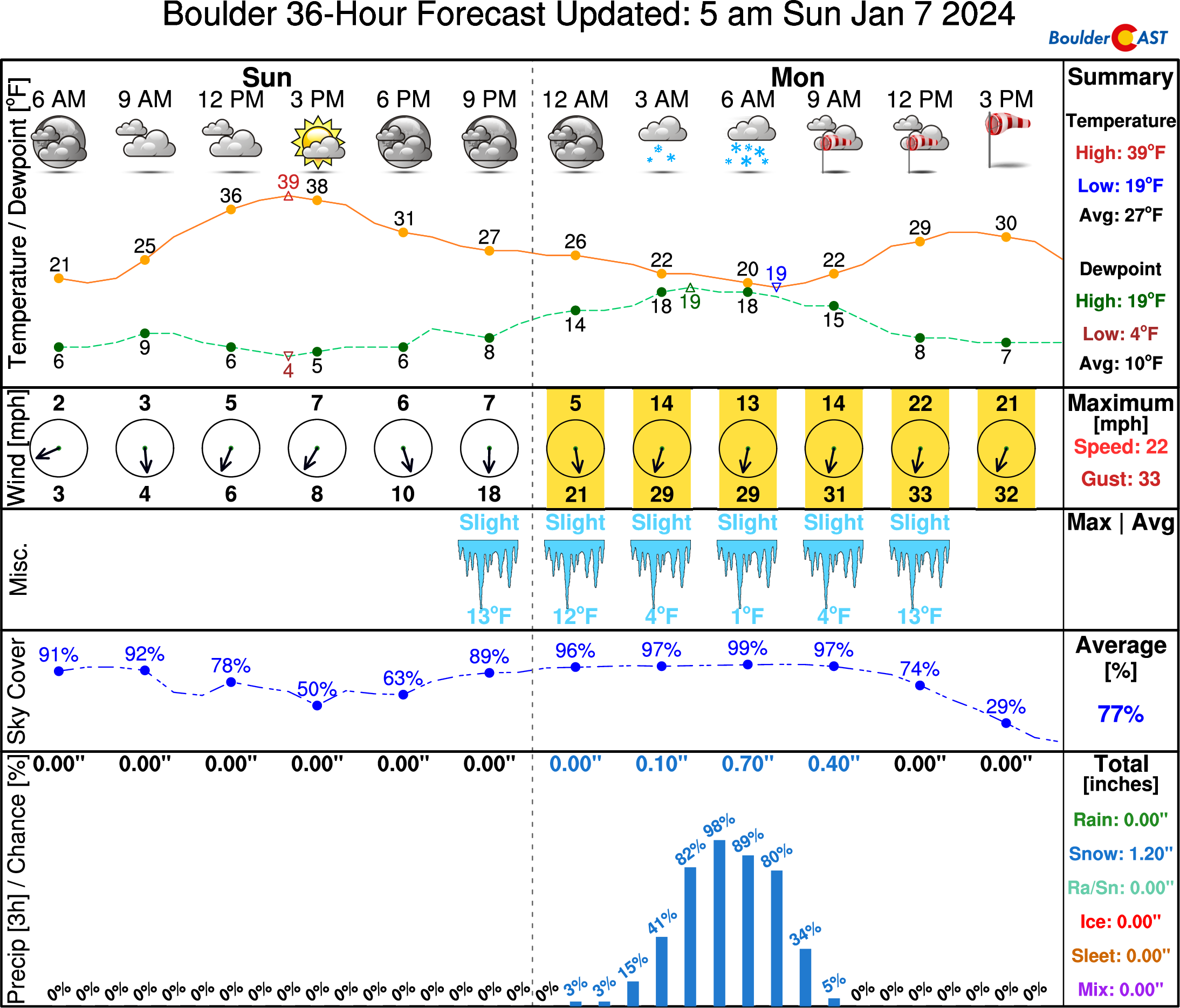
The more significant snow amounts and impacts on Monday with be closer to the heart of Denver and through areas south of there. For example, in Centennial, the snow will last longer, be more intense and overlap with stronger winds. Temperatures will be in the teens while it is snowing with wind chills close to zero.

Shown below is our snowfall forecast map for this event, including all snow falling Sunday night into Monday afternoon. Generally we are expecting a trace to 4″ across the Metro area (highest far south), with 3-7″ possible in the southern Foothills and Palmer Divide. If the Euro model verifies, we’ll would only barely squeak into the lower end of these ranges, but if the short-range models verify, we could end up in the upper tier. As mentioned, our confidence is somewhat low with this one.
The timing of the heaviest snow banding is shaping up to be between 3AM and 9AM, with likely impacts on the Monday morning commute from the timing alone. Things will get dicier the further south you are in the Metro area with Elevated impacts along and south of Interstate 70, but just Minor impacts further north. Snow will taper off in Boulder through the morning and for the Denver area by early afternoon.
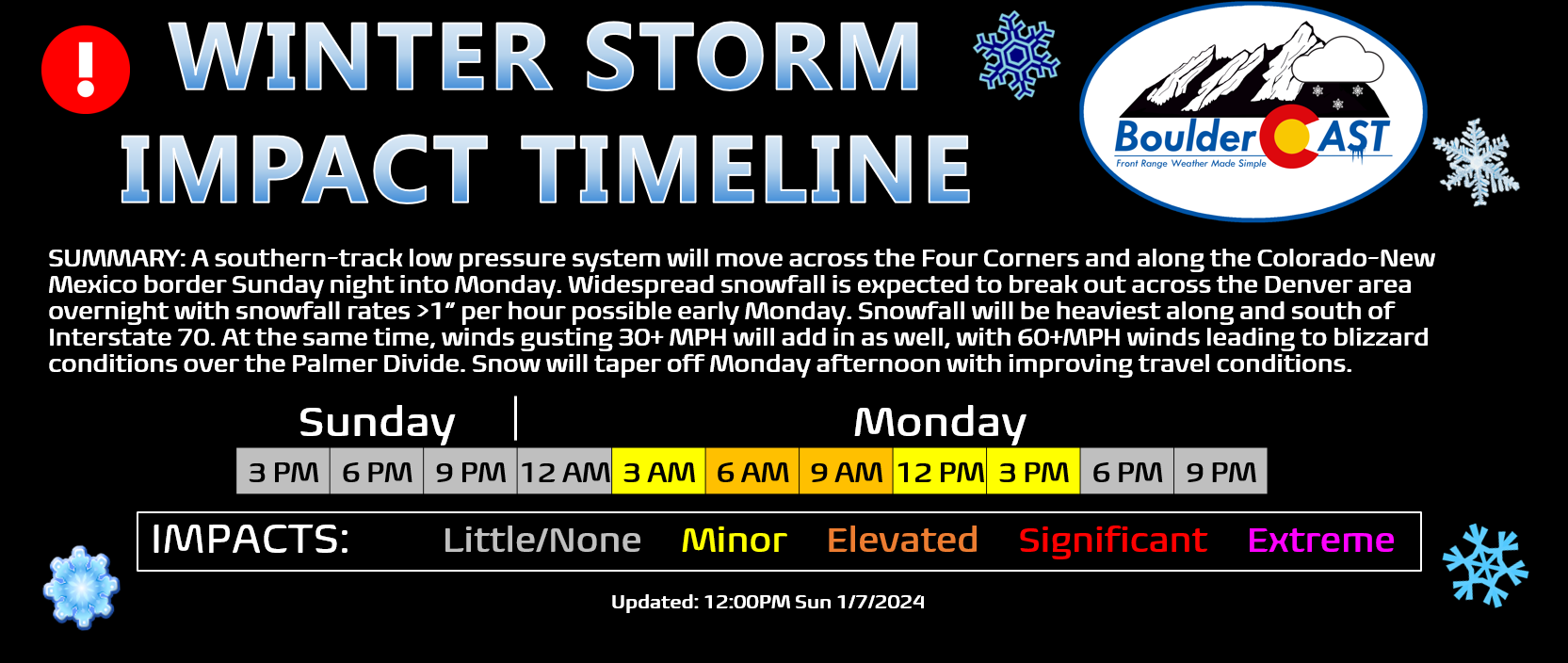
Colorado is lit up with numerous winter and wind related highlights right now. These will only expand as this winter storm system draws closer Sunday and unfolds for us early Monday! Based on trends in the short-range guidance, it is likely Denver and the southern suburbs will need a Winter Weather Advisory so look out for that. Boulder is probably in the clear. Regardless of what gets posted, plan on wintry travel impacts early Monday ranging from minor (north) to elevated (along/south of Denver) to potentially significant (Palmer Divide).

That’s all we have for now. Check back on Monday for our usual weekly weather outlook post. We will have a chance at our first real Arctic outbreak of the season later in the week ahead with likely below zero temperatures. There’s still quite a bit of uncertainty on where exactly the coldest airmass may end up, but Colorado has a chance at it…. stay tuned and subscribed!
Get BoulderCAST updates delivered to your inbox:

Go Premium, get all the perks.
Daily Forecast Updates
Get our daily forecast discussion every morning delivered to your inbox.
All Our Model Data
Access to all our Colorado-centric high-resolution weather model graphics. Seriously — every one!
Ski & Hiking Forecasts
6-day forecasts for all the Colorado ski resorts, plus more than 120 hiking trails, including every 14er.
Smoke Forecasts
Wildfire smoke concentration predictions up to 72 hours into the future.
Exclusive Content
Weekend outlooks every Thursday, bonus storm updates, historical data and much more!
No Advertisements
Enjoy ad-free viewing on the entire site.
Enjoy our content? Help us out and give it a share:


You must be logged in to post a comment.