
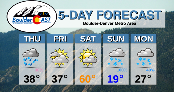
Winter weather is right around the corner for northern Colorado with two storm systems set to impact the area in the coming days. The first will produce freezing drizzle and light snow Thursday night, while the second will usher in bitter cold temperatures and accumulating snow for Sunday and Monday. We discuss both storms and give our initial thoughts on potential snowfall accumulations for the weekend.
At a Glance:
- Two rounds of wintry weather will impact the Front Range in the coming days
- Temperatures drop into the lower 20’s Thursday night with freezing drizzle and light snow possible in the Metro area
- An even stronger and colder winter storm will move in Saturday night, highs in the teens and 20’s
- Upslope will be limited with the second storm, but the jet stream will be a wildcard for heavy snow bands
- Potential snowfall amounts Sunday into Monday of at least 2-6″ for the lower elevations, up to 12″ possible
Help support our team of Front Range weather bloggers by joining BoulderCAST Premium. We talk Boulder and Denver weather every single day. Sign up now to get access to our daily forecast discussions each morning, complete six-day skiing and hiking forecasts powered by machine learning, first-class access to all our Colorado-centric high-resolution weather graphics, bonus storm updates and much more! Or not, we just appreciate your readership!

Round #1: Thursday night into early Friday
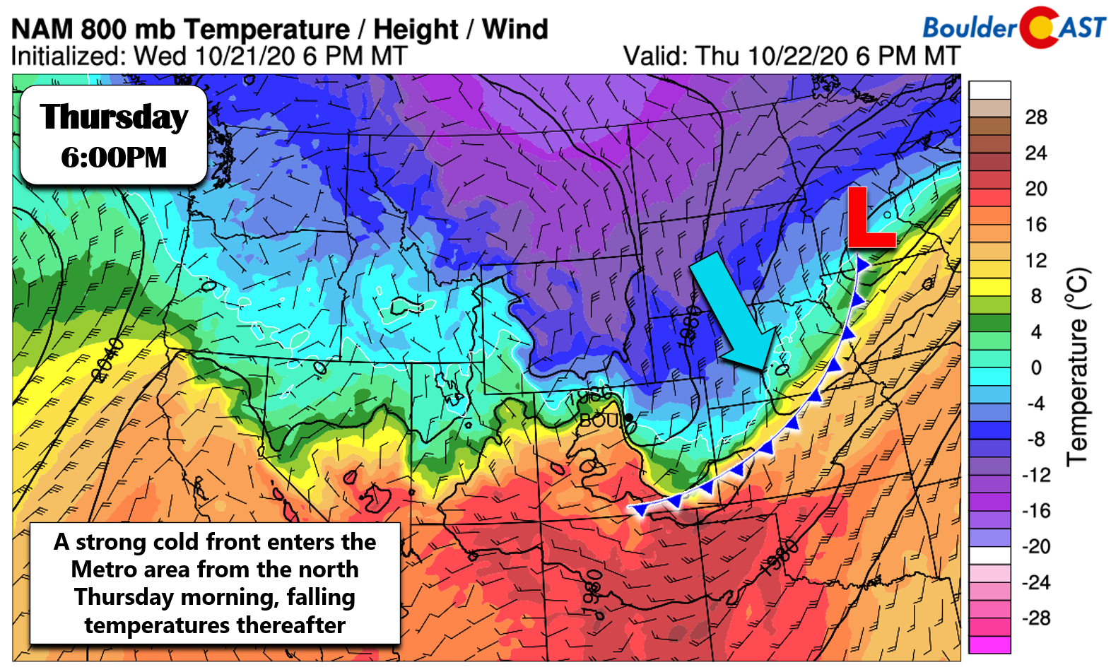
As we alerted you to in our weekly outlook on Monday, a cold front blew through the area earlier this morning. Temperatures are expected to be much colder today than they were on Wednesday. The storm bringing us this cold front is a clipper-type system all the way up in the northern Great Plains. It’s a quick-mover, but it is packing a Canadian airmass on the backside. The trailing cold front from the parent low pressure in Minnesota stretches all the way back into eastern Colorado. This set-up is shown in the forecast map valid for Thursday evening below.
If you haven’t been following the news, or didn’t happen to look westward at all yesterday to see the incredible pyrocumulus clouds, the East Troublesome Fire near Grand Lake exploded more than 100,000 acres in just 24 hours. It quickly became the fourth largest fire in state history, joining the likes of 2020’s Pine Gulch and Cameron Peak Fires. Elsewhere, little growth was noted on Wednesday with the Lefthand Canyon or Calwood fires in Boulder County.
Quite the nocturnal smoke plume coming of the #EastTroublesomeFire right now on radar…It is burning very hot: https://t.co/p2MzBiunVq#COwx pic.twitter.com/U9PlS4ZDk8
— BoulderCAST Weather (@BoulderCAST) October 22, 2020
The good news: the moist and chilly airmass behind today’s cold front will help out with all of the fires that are east of the Continental Divide. The bad news, however, the airmass doesn’t have the breadth to get up and over to reach the East Troublesome Fire on the other side. Much needed relief for that area will have to wait until Saturday night when a stronger, deeper frontal boundary is expected to push across the entire state of Colorado. More on this in a moment…
The more pressing concern will be what happens Thursday evening as the deeper moisture and even colder air oozes into the Denver Metro area from the northeast. Around sunset, a secondary push of colder air will arrive to the Plains with widespread low clouds, fog and light precipitation expected to break-out. There is actually some drizzle already occurring in some areas Thursday morning, but this should relax through the day. Most high-resolution weather models are indicating that the saturated layer overhead tonight will not drop much below -10°C, so we expect the dominant precipitation type to be freezing drizzle, instead of light snow. However, the top of the cold airmass will reach up to about 10,000 or 11,000 feet elevation, so it is a moderately deep cool-down. Because of this, there will surely be some snowflakes mixing in with the freezing drizzle overnight. Any accumulation would be very light, less than a dusting. Temperatures will fall into the low to middle 20’s overnight, so a light glaze of ice and/or snow is possible so do be careful if traveling.
NAM-NEST model radar composite animation from Thursday evening into mid-day Friday
Another word of caution: there are no Freeze Warnings issued for northeast Colorado. This is because our temperatures have already dropped below freezing on a handful of occasions this fall. However, Thursday night will be the coldest so far for the Front Range. Make sure to drain any above ground pipes, sprinklers, or hoses. It will be even colder this weekend into early next week, so might as well get it done now!
Lingering freezing drizzle and light snow will wrap up Friday morning, giving way to lifting cloud bases and potentially a few peeks of sunshine Friday afternoon. Overall, though, it will be a mostly cloudy and cold day with highs in the mid to upper 30’s, not at all unlike our Thursday.
Round #2: Saturday night into Monday
The main event is waiting in the wings as an even stronger winter storm system will impact the entire state of Colorado over the upcoming weekend. This one is the “real deal”. There are a lot of details still to work out, so we will keep things general for now…but do know that snow is on the way for the entire region, Plains and Mountains alike. The next approaching storm will take a track much further south and west. In fact, it will actually be so far southwest that much of the energy and lift will miss our area.

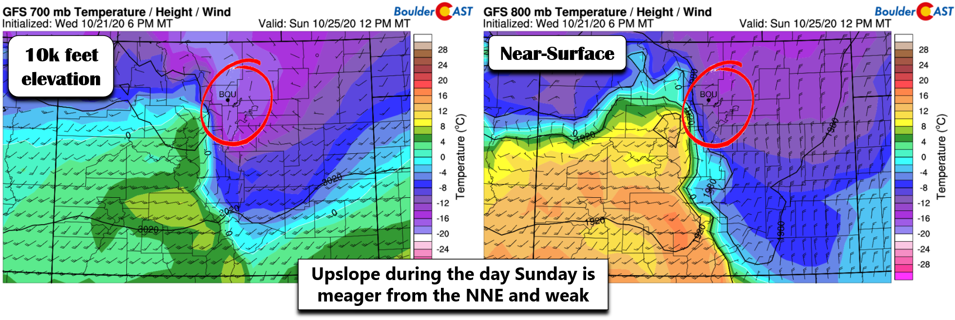
This track will also limit the intensity and efficiency of upslope in our neck of the woods. Below are two wind and temperature forecasts from the same model for Sunday afternoon. The one of the left is for the level at about 10,000 feet elevation, while on the right is near ground-level in Denver. At both levels, we’re seeing very weak winds and generally only mildly favorable directions for the upslope in the Front Range. This is a result of the storm tracking so far west. Air temperatures are bitter cold at both levels, however. There’s no doubt about that. Highs on Sunday will be near 20°F on the Plains and in possibly the single digits in the Foothills. Brr! Sunday will definitely be a good day to get that fireplace going while you watch the falling snow!
Don’t fear…upslope isn’t the only game in town! The wildcard for Sunday’s snowstorm will be the overhead jet stream. Well, to be more precise, the overhead jet streams (plural!). Both the polar and subtropical jets will be flowing through the Rocky Mountain State this weekend (shown below). We’ll be receiving the bitter cold air from the polar jet, but also the added moisture from the subtropical jet. This merger is what has our team most excited this weekend!
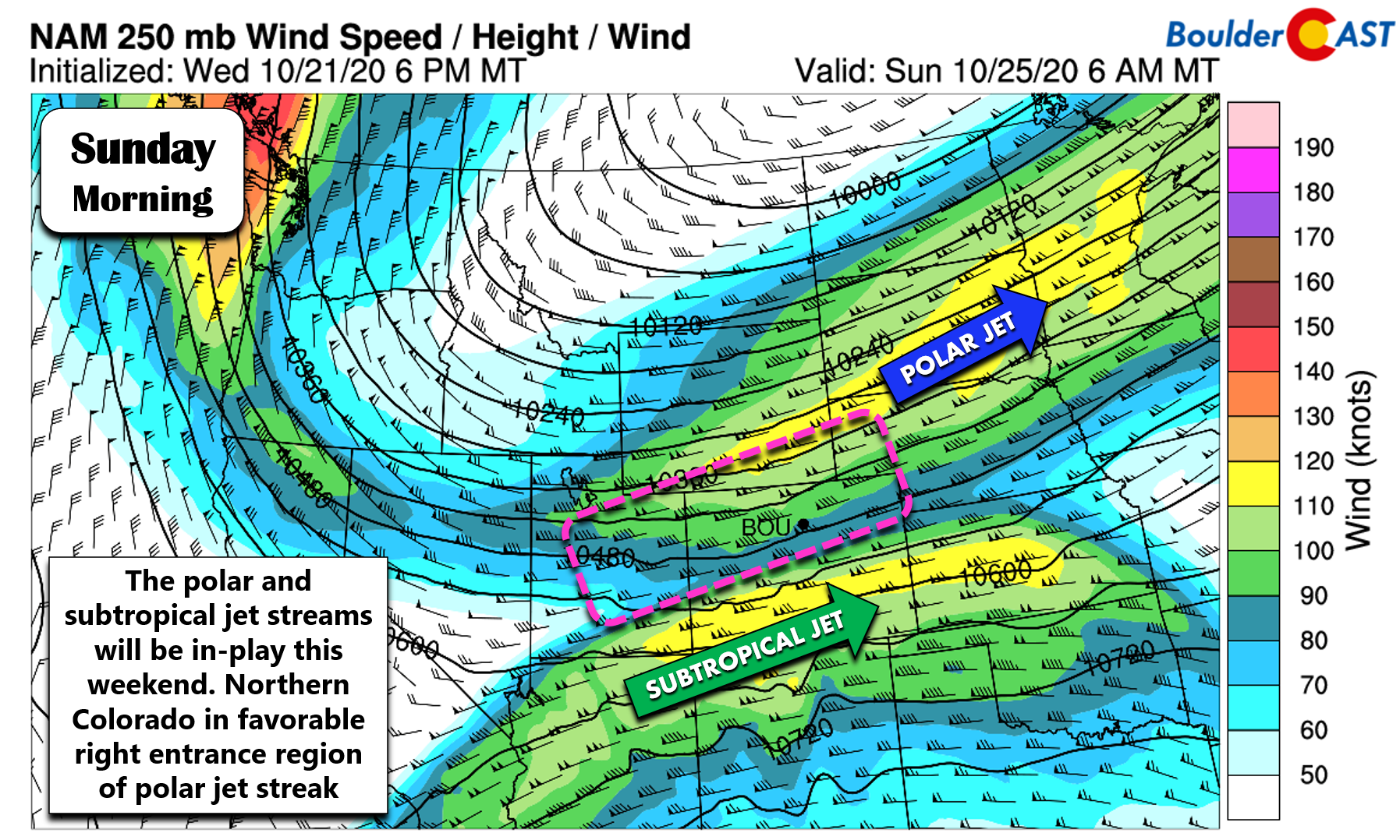
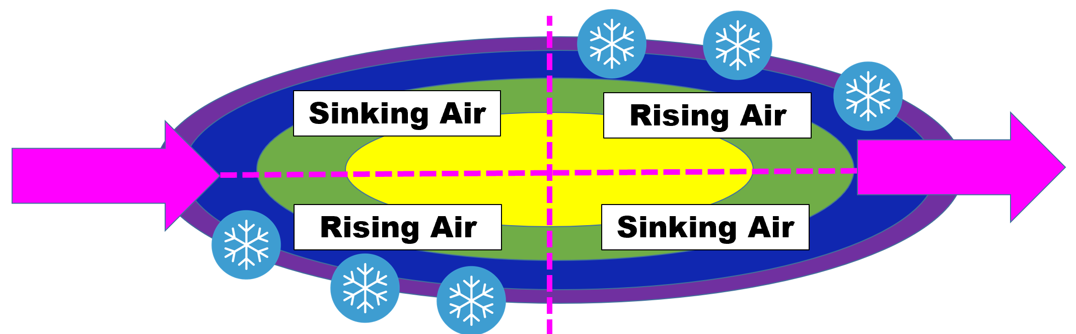
The latest guidance from the models, which has been somewhat consistent for many days now, puts much of northern Colorado in a favorable position for jet-forced heavy snow bands to develop (pink box above). This right-entrance region of any jet streak contains concentrated pockets of lift capable of producing localized heavy snow bands. A simplified quadrant diagram for jet streaks and snow is shown below. We’ve talked about this many times in years past. Not only will this feature be present and accounted for on Sunday, it will linger for an extended period of time across our region, potentially opening the door for significant accumulations in locations which end up under the heaviest snow bands for prolonged periods. Despite upslope being largely unimpressive with the storm, this jet set-up alone will more than make up for it!
The problem for now is that pinpointing the exact location of the banded snow is difficult this far out. We do believe most of the Front Range will catch this banding sometime from late Saturday night into Sunday night, potentially much of this time. The resulting snow totals could be huge if this does happen…6 to 12″ or more!
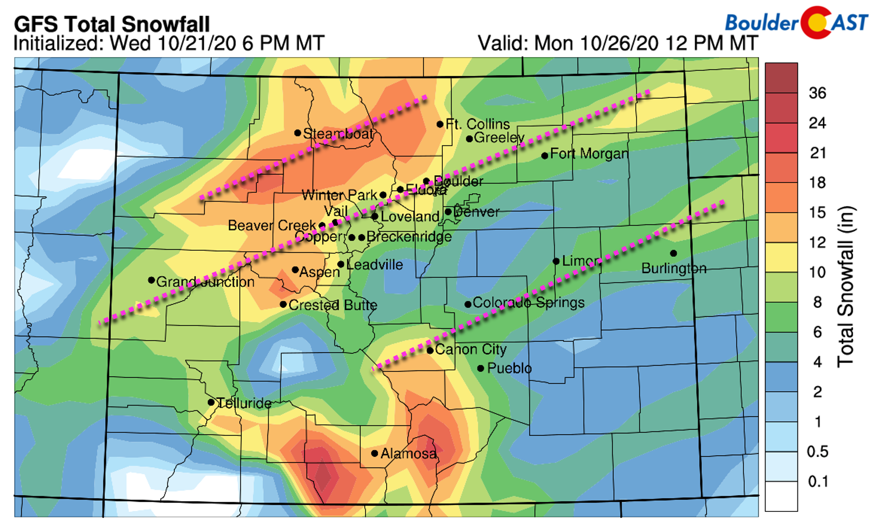
The latest GFS model forecast using our custom snowfall algorithms is shown below. We’ve annotated dashed lines indicating the expected orientation of the jet-forced snow bands (southwest to northeast). Despite the lower resolution of the model, it seems to be picking up well on the banding, for what it’s worth.
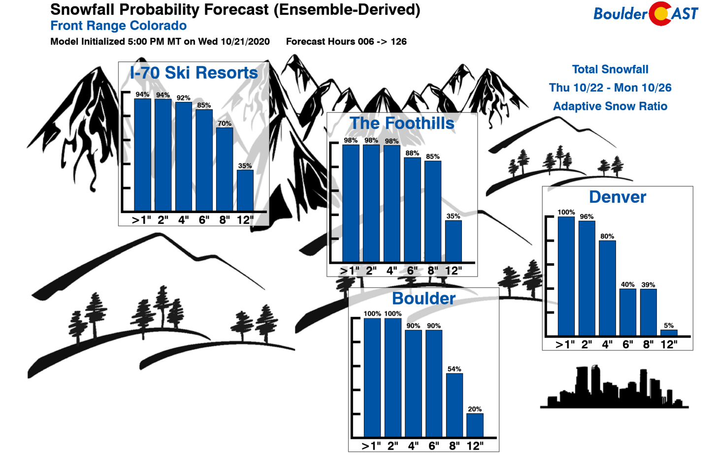
Right now, we just need to be patient and wait for things to evolve and come together in the next few days. The finer details of the jet stream are so tricky to forecast three days out. Most signs do point to a sizable snowfall event for the Boulder/Denver area and across the Mountains and Foothills. At the moment, we’ll cautiously throw out a prediction of at least 2-6″ of snow for the entire lower elevations from Boulder to Denver. The Mountains likely will see 6-12″ (or more) from this system. We’re also confident some of you will receive more than 6″ by Monday afternoon, with perhaps a few spots picking up more than 12″. We just can’t say where yet. Our latest Snowfall Probability Charts are shown below. This should give you an idea of what to expect this weekend into early next week. Upslope isn’t a major player this time, so the favored upslope areas like Boulder may not necessarily see the most snow. Also be sure to check our SnowTracker page for the latest from the weather models and our winter weather forecast products, including how much powder may be dumping on the ski resorts.
We all so desperately need this moisture. Let’s hope Mother Nature delivers. Stay tuned! There will be more to follow in the coming days….
.
Subscribe to receive email notifications for BoulderCAST updates:
We respect your privacy. You can unsubscribe at any time.
Help support our team of Front Range weather bloggers by joining BoulderCAST Premium. We talk Boulder and Denver weather every single day. Sign up now to get access to our daily forecast discussions each morning, complete six-day skiing and hiking forecasts powered by machine learning, first-class access to all our Colorado-centric high-resolution weather graphics, bonus storm updates and much more! Or not, we just appreciate your readership!
.
Spread the word, share this BoulderCAST post:
.


You must be logged in to post a comment.