
After an eventful weekend with two new wildfires igniting in Boulder County, the weather will become slightly less favorable for fire growth through the week in the higher terrain. Across the Plains, it will be mainly dry this week, but there are changes queuing up for the late-week period into the weekend including the potential for our first snowfall since early September!
This week’s highlights include:
- The jet stream will reside just north of Colorado through the week, keeping the strongest winds and coldest air to our north
- Warm & dry conditions will be present through mid-day Thursday across the lower elevations before a strong cold front arrives
- Thursday night into Friday will be much colder with upslope and slight chances for wintry precipitation (snow and/or freezing drizzle)
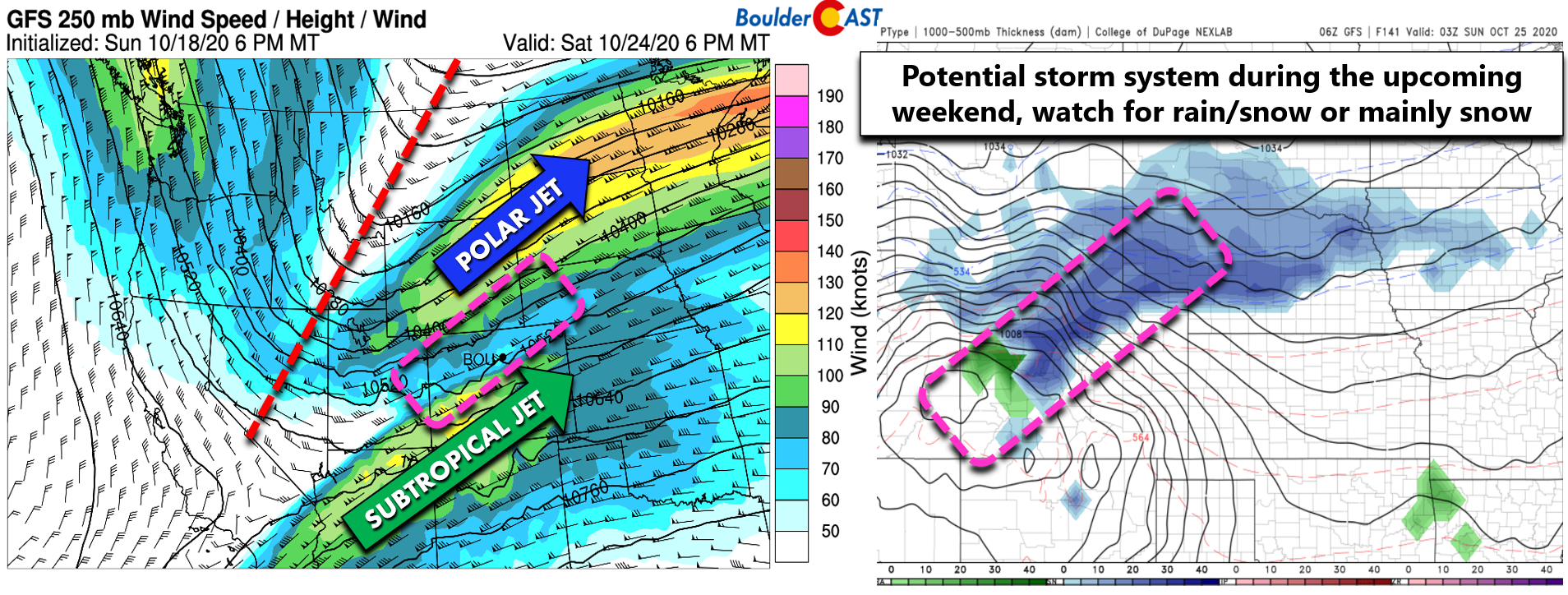
- Watching a potential stronger system for the weekend which may tap into the subtropical jet
DISCLAIMER: This weekly outlook forecast is created Monday morning and covers the entire upcoming week. Accuracy will decrease as the week progresses as this post is NOT updated. To receive daily updated forecasts from our team, subscribe to BoulderCAST Premium.

From fire to drizzle
Well, the weekend was more eventful than most of us wanted in Boulder County. Fire danger was extraordinarily high on Saturday as winds gusted in excess of 60 MPH in the Foothills. The focus mostly was on the potential explosive expansion of existing wildfires, like the East Troublesome and the Cameron Peak. We did not foresee two new ones blowing up right on our very doorstep…
The Cal Wood Fire ignited Saturday morning near Jamestown and quickly expanded eastward all the way to Highway 36 north of Boulder. In less than 12 hours, the Cal Wood Fire became the largest in Boulder County history at nearly 9000 acres. The scenes shared were incredible, including dual-rotating fire vortices and a severely sheared-out pyrocumulus cloud.
Time-lapse of the new #CalwoodFire yesterday near Boulder, Colorado! 🙁
Permission: Jennifer Stucki@WeatherBug pic.twitter.com/3fKs2SCFcU
— Live Storm Chasers (@Livestormchaser) October 18, 2020
Even as a scientist studying extreme weather & wildfire in a warming climate, I was shocked by how fast #CalwoodFire roared down the Colorado Front Range foothills this afternoon. This is footage of one of several large fire vortices I observed while leaving area. #COwx @nplareau pic.twitter.com/9yJRdNo14X
— Daniel Swain (@Weather_West) October 18, 2020
Fortunately, just a few hours later Mother Nature delivered a welcomed Canadian cold front with a jolt of moisture, low clouds, fog, and eventually drizzle. This was only our second few spits of moisture in Boulder since the snowstorm in early September. It has been an incredibly dry last six weeks…and really, last six months!
A cold front will arrive to the area around 9PM this evening w/ a much needed jolt of moisture and low clouds. The problem is, it's a shallow front and likely will only reach up to ~8000 feet elevation. Hopefully this will help slow the fires down #COwx #CalWoodFire #Boulderwx pic.twitter.com/7CeBCcmDaH
— BoulderCAST Weather (@BoulderCAST) October 18, 2020
The impact this change in airmass had on the infant fire was clear by Sunday morning. This is the view from a CDOT camera along Highway 36 near Altona between Boulder and Lyons. Much better!

On Sunday, a second fire ignited in Boulder County, just east of Ward in Lefthand Canyon. This area was “above” the cool and moist airmass provided by the welcomed cold front. While drizzle fell in Boulder and the lower Foothills, it was sunny, warm, and gusty where this secondary fire was born. Growth conditions were not as favorable on Sunday and the Lefthand Canyon Fire, as it has been named, remains only a few hundred acres in size as of Monday morning.
Of course, we are not our of the woods yet as the weather that unfolds this week will determine if these new fires and the many others are able to spread further.
The Catch-22
The main problem with still having large active wildfires in our state in late October are the rapidly increasing wind speeds. We’re no longer in the doldrums of summer. 50 to 70+ MPH wind gusts in the Mountains and Foothills are common this time of year as the jet stream begins to sag further south. This is what makes the current smoldering state of things in Colorado frankly a little frightening. Here’s a look a the position of the jet stream today across the United States.
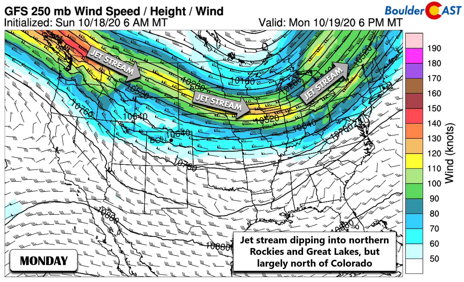
Fortunately the jet will largely remain across Montana and Wyoming again this week. BUT, it’s a catch-22… Right now we need the mid-latitude storm systems that ebb and flow along the jet stream for their beneficial lift and precipitation, but undoubtedly strong winds will accompany them as well.
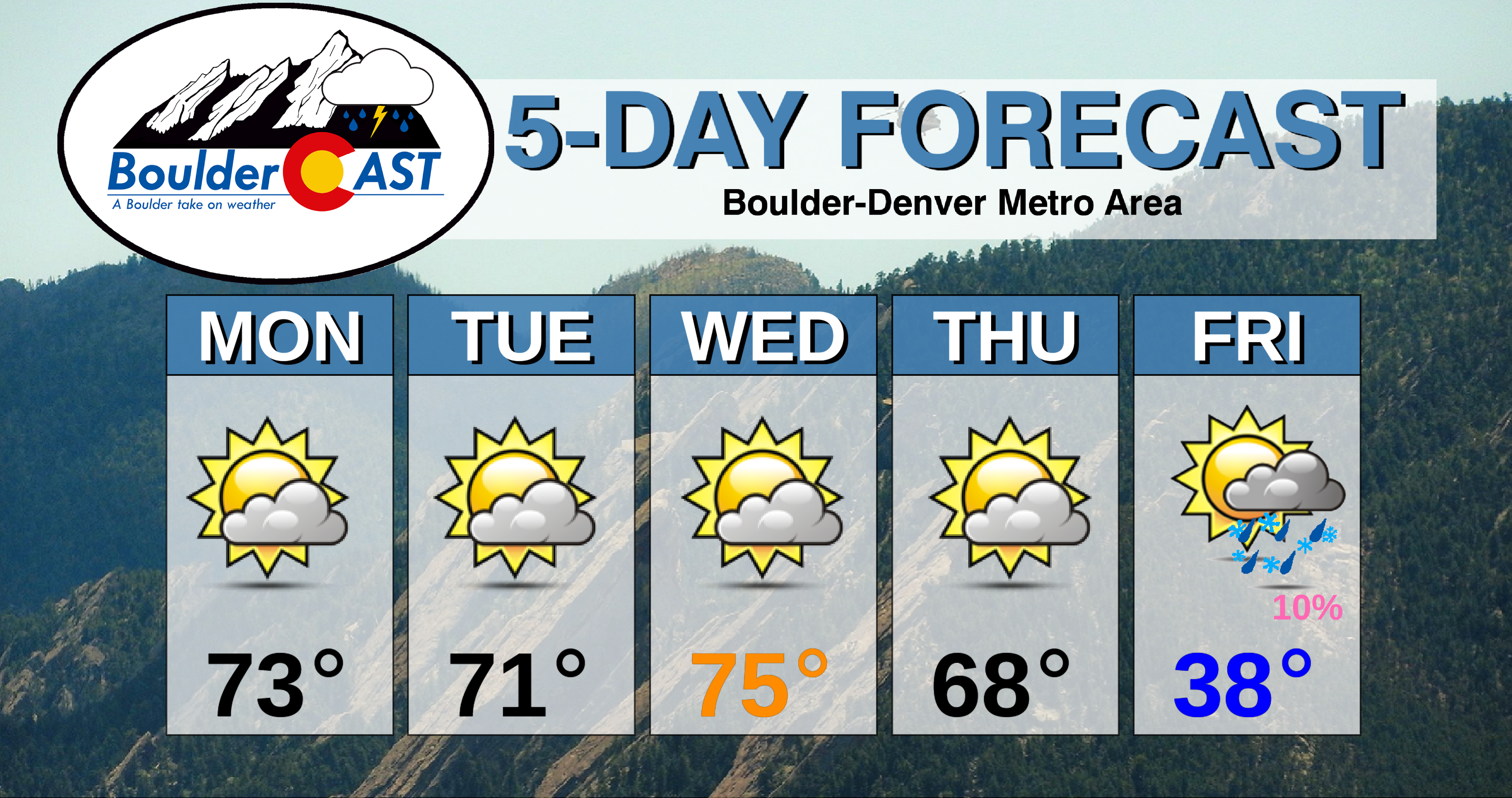
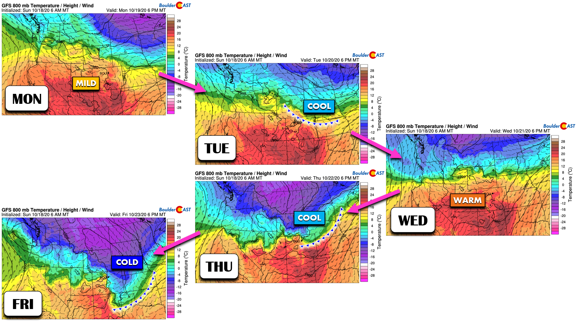
This jet position over the northern Rockies and continued dry northwest flow aloft in Colorado will lead to another mainly dry week with temperatures shifting up and down as several cold fronts impact eastern Colorado:
- Monday will be mild in the 70’s. Gusty winds up to 55 MPH will be possible in the Foothills during the morning hours, but winds will relax through the day. Another mountain wave will develop Monday night into Tuesday morning, but it will be weaker with gusts generally below 45 MPH in the Foothills.
- Tuesday will be warm too (lower 70’s), at least for the first half of the day as the initial cold front of the week oozes southward into the Front Range during the afternoon.
- Wednesday will see temperatures rebound quickly from the cooler airmass. It should be the warmest day of the week with southwest flow at the surface. We’re expecting middle 70’s.
- The second and stronger front lining up this week will move into the area on Thursday. At the moment, the front appears to arrive around mid-day which will lead to a cooler day overall (morning 60’s or perhaps 70°F and falling).
- Even colder air will filter into the area Thursday night into Friday with highs quite chilly in the 30’s.
This potent front late in the week will offer our only chance of precipitation and it may come in the form of post-frontal fog and drizzle Thursday night into Friday. It’s very difficult to predict upslope drizzle this far out, but we will mention it at least so you can plan ahead. Also keep in mind that temperatures may be cold enough for this to be freezing fog and freezing drizzle, which is always a travel concern. There’s also a slight chance the a weak jet could help produce actual snow showers sometime between Thursday night into Friday night. This aspect is quite uncertain, with any potential accumulations being small and mainly confined to the higher terrain.
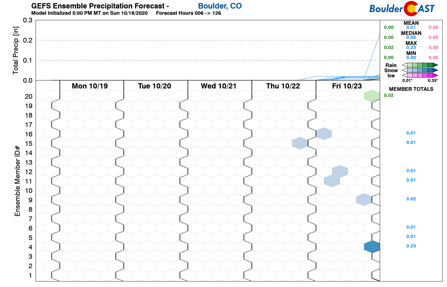
One thing that could help us combat the fiery dilemma at-hand would be a southern track, classic upslope storm system. These tend to pack less wind and offer more in the way of significant rain and snow for our area. However, with ongoing La Niña conditions, this scenario is quite unlikely. We’re not going to get too excited yet, but there is some model credence for a “somewhat” southern storm to reach Colorado during the upcoming weekend. The subtropical and polar jet streams may briefly dance across our state late in the weekend leading to the potential for our first snow event since early September. It’s certainly too far out to say for sure, but this is something to watch for the upcoming weekend. Anytime the subtropical jet enters the picture, moisture immediately increases and things can get interesting…
Overall, weather this week should be less favorable for rapid fire growth with lighter winds and higher relatively humidities, even capped off with a little bit of rain/snow this weekend. We want to express our thanks and appreciation to the many firefighters and responders that have been battling the new fires in our area this weekend and the much larger fires over the last four months statewide.
Have a good and safe week!
Forecast Specifics:
Monday: Partly to mostly cloudy, warm and breezy at times. Highs in the low to middle 70’s on the Plains. Upper 50’s in the Foothills with gusty winds in the morning to 55 MPH.
Tuesday: A mix of wave clouds and sunshine. Highs in the low to middle 70’s early, then falling temperatures behind and afternoon cold front. Gusty winds in the Foothills in the morning to 45 MPH.
Wednesday: Another unseasonably warm day under partly clouds skies. High temperatures in the middle 70’s on the Plains and in the lower 60’s in the Foothills.
Thursday: Partly cloudy with a strong cold front arriving around mid-day or slightly after. It will be a warm morning with temperatures in the 60’s to near 70 degrees, then rapidly falling temperatures through the afternoon into evening. Low clouds, freezing drizzle and or light snow could develop Thursday night into early Friday behind this front.
Friday: A mix of clouds and sun. Possibly morning fog/drizzle, then a slight chance of late-day snow showers. Highs in the upper 30’s on the Plains and Foothills.
High Country: Gusty winds possible early Monday and again Monday night into early Tuesday with mountain waves developing across the Front Range. Overall it will be a dry week in the Mountains with west and northwest flow. There is a chance of snow showers Thursday evening into Friday evening across the northern Mountains, but any accumulation would be light, a few inches or less. A stronger weather system will impact the state over the upcoming weekend and it will offer better chances for more appreciable snow. Check our PowderCAST page for daily updated forecasts for all the Colorado ski resorts. Here’s a look at the ski resort forecasts for Friday:

Help support our team of Front Range weather bloggers by joining BoulderCAST Premium. We talk Boulder and Denver weather every single day. Sign up now to get access to our daily forecast discussions each morning, complete six-day skiing and hiking forecasts powered by machine learning, first-class access to all our Colorado-centric high-resolution weather graphics, bonus storm updates and much more! Or not, we just appreciate your readership!
.
Spread the word, share the BoulderCAST forecast!
.


You must be logged in to post a comment.