Just when it seemed we had the shortest snow season and earliest last snowfall records in the bag, Mother Nature is about to throw a late-spring wrench into the forecast! A winter storm is heading for Colorado and it will bring snow to everyone Friday into Saturday even across the lower elevations in Boulder and Denver. While the Foothills communities should brace for a major damaging snow event, some crucial aspects of the forecast remain fuzzy which has allowed only low confidence in the exact snow amounts for the immediate Metro area. Let’s take a look at the latest details and go over our preliminary snowfall expectations and impacts.
At a Glance:
- A strong and unseasonably cold storm system has set its targets set on Colorado with impacts Thursday night into Saturday night
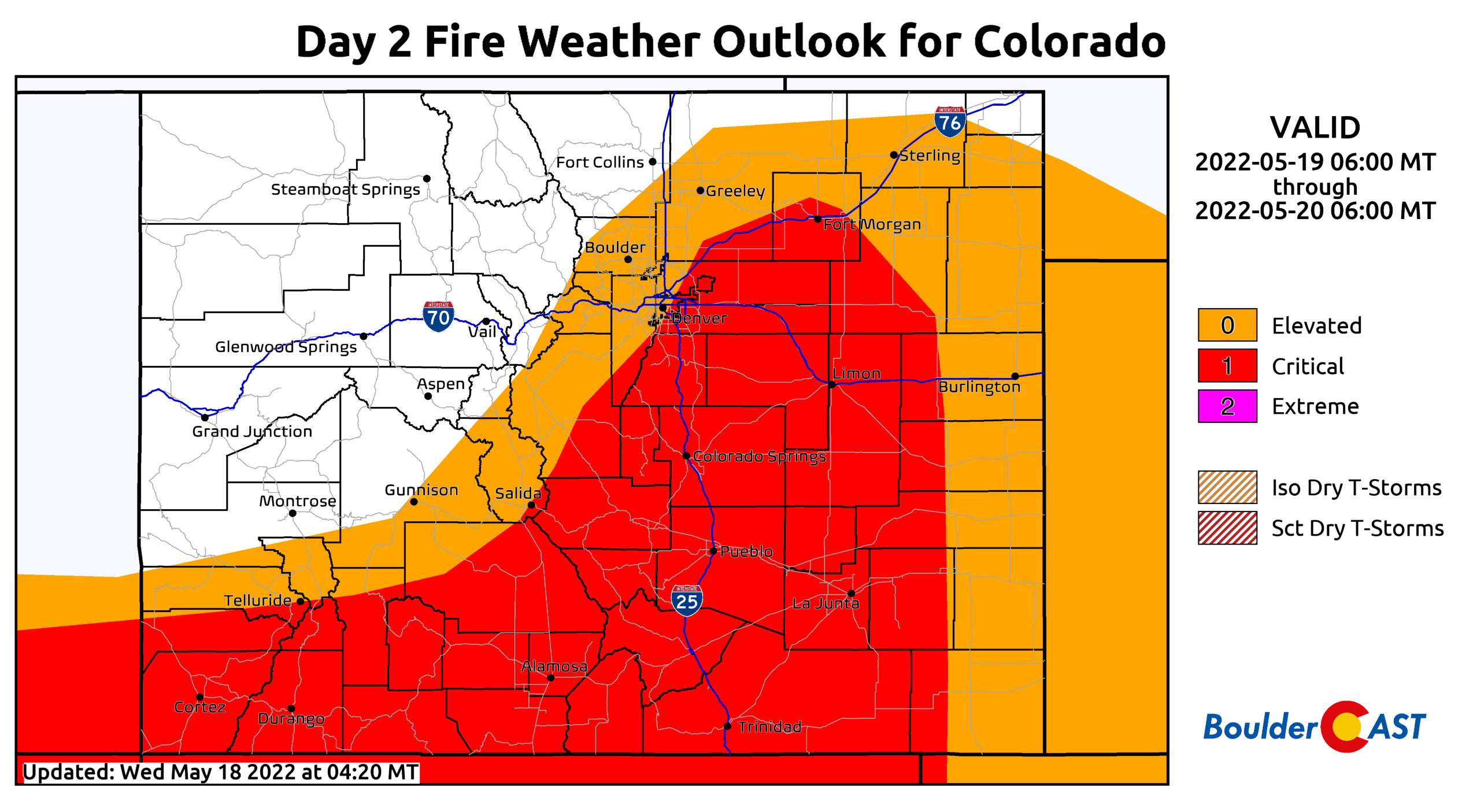
- Potential record highs Thursday near 90 degrees with critical fire danger
- A cold front blows through Thursday night with rain/snow developing on Friday and lingering into the weekend
- Everyone will change-over to snow as this is a cold system, even the lower elevations
- 8-16+” of snow in the Foothills is expected, with up to 6″ in the Denver Metro area
- 1-2″ of liquid will fall, helping but not curing the ongoing drought
- Confidence is low for snow amounts below 7000 feet elevation — stay aware for a critically changing forecast!
- Sub-freezing temperatures are likely Friday night and Saturday night
We discuss Boulder and Denver weather every single day on BoulderCAST Premium. Sign up today to get access to our daily forecast discussions every morning, complete six-day skiing and hiking forecasts powered by machine learning, access to all our Front Range specific weather models, additional storm updates and much more!

S
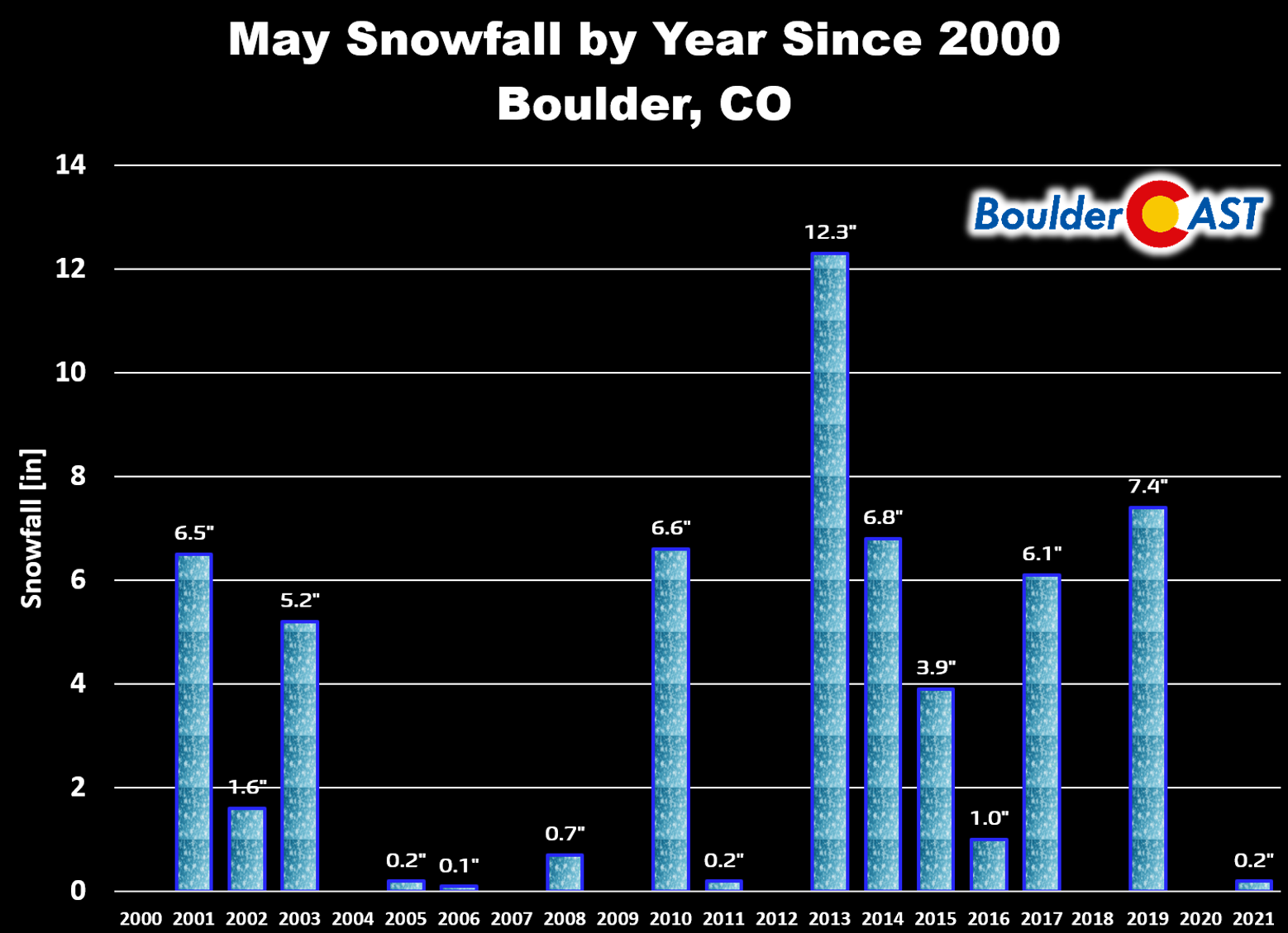
now is on the way! We just double-checked, and yes it is indeed showing “May” on the calendar. As you are probably well aware, that doesn’t mean much in the Front Range. May snowfall is commonplace here with roughly a 75% chance of accumulating snow in Boulder during the month of May since the year 2000. It often isn’t much snow, but snow nonetheless.
Despite more than 80% of you declaring our snow season was over and done with in our recent community poll, late-season snow is indeed on the way!
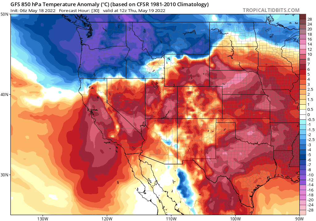
We first alerted you to this big change in our weather in our weekly outlook back on Monday — at the time we had forecasted a 45 degree temperature drop between Thursday (89°F) and Friday (44°F) with rain/snow in the works. That forecast will turn out to be spot on with a late-season taste of winter returning to the Front Range on Friday and Saturday!
Before things take a soggy and snowy turn, however, Thursday will follow suit from our weather the last several weeks. There’s not much to say really — it will be a hot, dry and breezy day with near-critical fire danger. You know the drill: no activities that could create sparks or open flames. Seriously, don’t let your guard down because a big precipitation event is on the horizon! The most devastating wildfires in Boulder County the last few years have occurred mere hours before widespread upslope precipitation broke out (e.g. the Marshall Fire, the Calwood Fire). Oh, and a high temperature near 90°F on Thursday will be right around the existing daily record for May 19th.
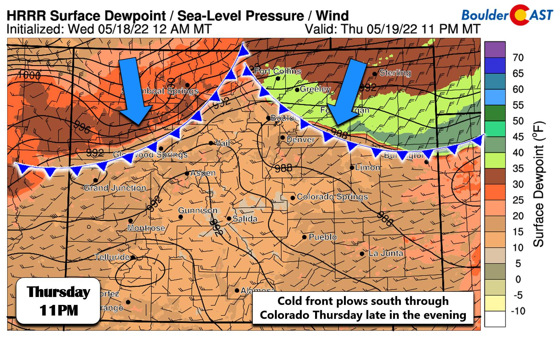
The big shift in our weather begins Thursday night with the passage of a strong cold front from the north. This front will end our two-week streak of unseasonably warm temperatures. It may take the better part of seven days before we see above normal temperatures again after its passage. Current guidance brings the front into the Denver area from the north between 7PM and 11PM Thursday night. This timing is well-agreed upon by the various models. Expect a sharp drop in temperatures from the 70s and 80s down into the 40s rather abruptly! The high-resolution forecast for surface dew points below allows for a clear visualization of the front’s location Thursday night.
Upslope will take hold immediately following the front, but moisture will be shallow, probably not enough to seed precipitation initially. Expect things to get going in and near the Foothills north of Denver early Friday morning, with precipitation overspreading the entire area through the day from north to south. Precipitation will be most widespread Friday afternoon into early Saturday morning, but may linger on-and-off into Saturday evening. A chilly weather pattern and daily chances for precipitation will remain through at least Tuesday of next week it seems. If you were looking forward our typically gloomy May weather, the extended forecast certainly has you covered!
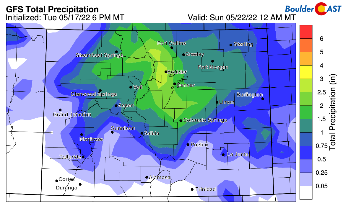
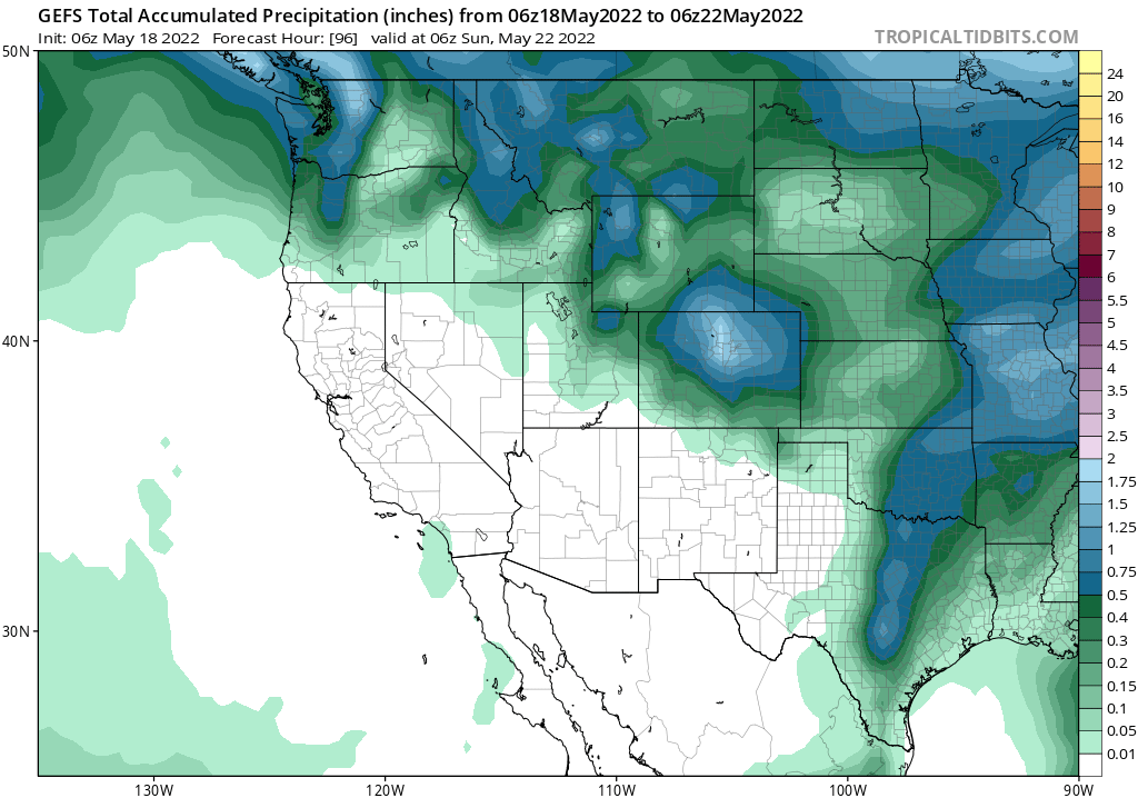
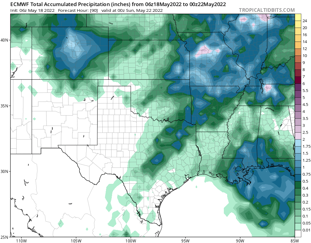
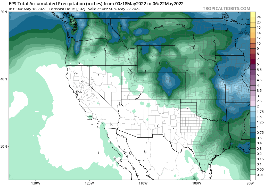
There was previously a rift in model precipitation forecasts a few days ago for this system, but that has been mostly rectified with nearly all models on-board for a Front Range soaker — and trending upwards! Let’s run through a few model projections of how much beneficial moisture is headed our way…
GFS — Over 2.5″ in Boulder and over 1.5″ in Denver
GFS Ensemble Mean (30 members) — Close to 1.7″ in Boulder and 1.3″ in Denver
European Model — Approximately 1.5″ for Boulder and Denver
European Ensemble Mean (50 members) — Around 1.3″ in Boulder, just shy of 1″ in Denver
NAM model — 1.8″ in Boulder and 1.3″ in Denver
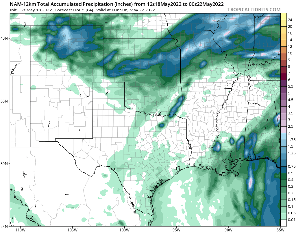
Canadian model — About 1.2″ in Boulder and Denver
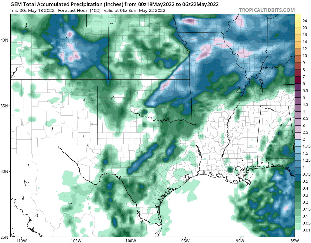
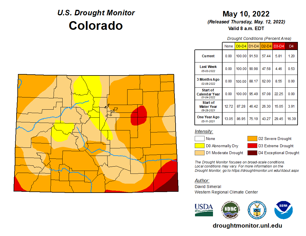
The takeaway here — from all of the models — is that our confidence is sky high for a significant precipitation event to end the week. There’s no doubt about that anymore! Precipitation amounts through Saturday evening will range from 1 to 2″ across the area with locally higher amounts in the Foothills not out of the question. This type of event, which will produce some 10% of our annual precipitation, will definitely help with the ongoing drought in not only the immediate area, but also across other parts of Colorado that need it more than we do.
The incoming low pressure originated out over the Pacific which tends to lean towards a warmer type of storm, but its broad reach will pull down a pocket of cold air from central Canada in the process. It’s for this reason that we are expecting late-season snowfall across the entire region — the Denver Metro area and Foothills alike.
Precipitation likely begins as rain across the lower elevations Friday morning with temperatures in the 40s. Things will be all snow in the Foothills above ~7000 feet where the beginnings of an historic late-season snow event will take shape first. A secondary surge of even colder Canadian air arrives during the day Friday which should bring snow levels down to include the entire Boulder-Denver area. Our custom algorithm for rain/snow has the line draped right over the Metro area by midday Friday.
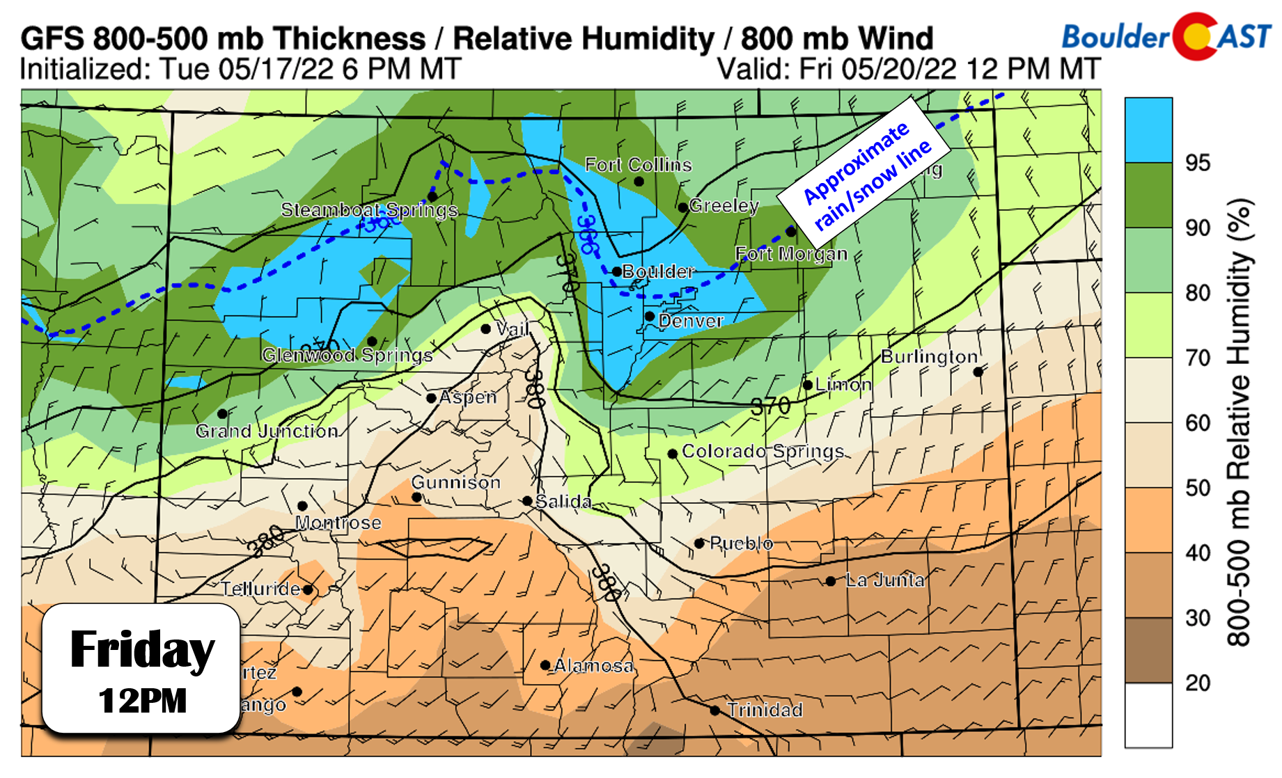
As temperatures continue to cool through the day, the rain/snow line will migrate southward and turn rain over to snow for the region. We think most areas will see rain/snow mix or all snow by Friday afternoon with temperatures in the low to middle 30s, though with the warm ground temperatures and extremely high late-May sun angle, accumulation will be fairly hampered until closer to sunset.
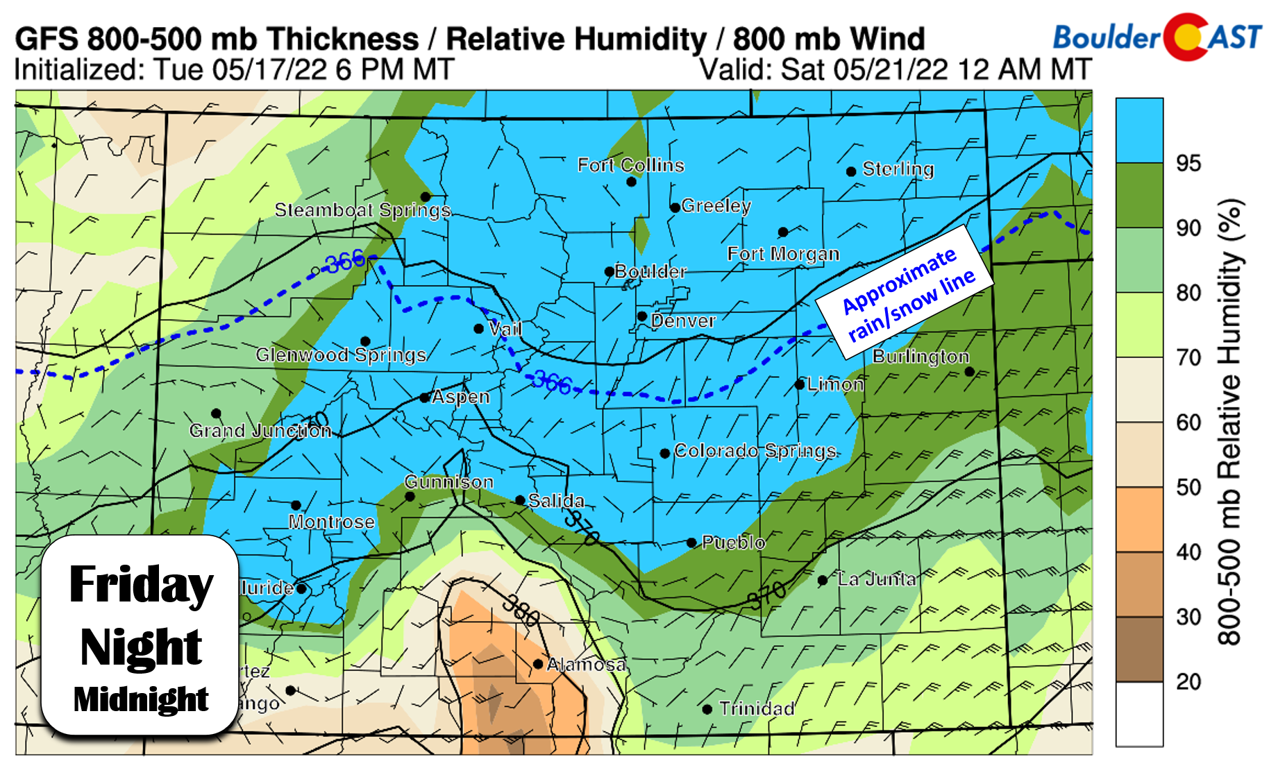
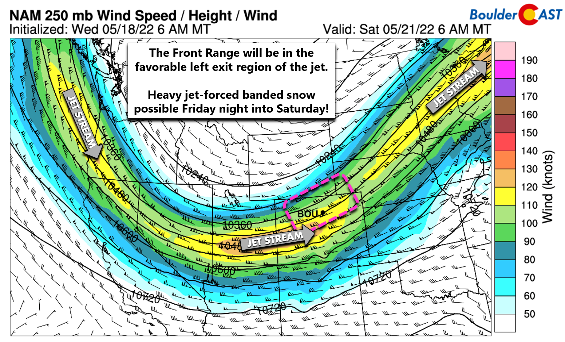
The timing with this storm has been fluctuating. It was later, then earlier, now it seems to be shifting slightly later again. Timing in this case will be critical for how much snow actually sticks and the resulting impacts that will occur. Unfortunately right now it looks like heaviest snow may fall late Friday afternoon into Saturday morning, with potentially the worst of it occurring during the overnight hours when locally heavy jet-forced snow bands will be possible (think 1″+ per hour snowfall rates) alongside deep upslope. This is the worst case scenario for the Front Range, with no sun hanging in the sky and temperatures near or slightly below freezing, heavy wet snow will have no trouble sticking to the fully leafed-out vegetation. Downed trees and power outages are a given in the Foothills, and at this point appear likely for the Denver Metro area as well especially the slightly higher areas in the western and southern suburbs above 5500 feet elevation.
Shown below is our preliminary snowfall forecast map for the event. Forecast ranges are wider than normal to account for the that uncertainty. This is just our first crack at snow amounts. There’s still more than 48 hours before we will even see the first snow sticking in Boulder and Denver. We’ll update this map at least one or two more times before the looming storm arrives.
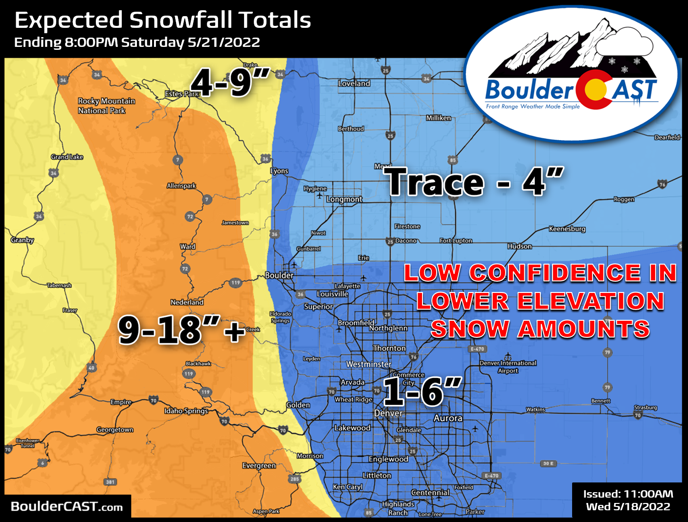
There’s no doubt that this will be a major snowstorm for the Foothills about 7000 feet elevation. These areas will be plenty cold enough and should easily see 9-18″ of snow up and down the Front Range, with locally higher amounts. We must stress that due to the circumstances, overall confidence in snowfall amounts is rather low below 7000 feet elevation right now. It’s really going to come down to how much snow dumps between 7PM Friday and 7AM Saturday when the sun is down. This will be the determining factor between just a snowy annoyance and something that could be quite damaging for our area. It only takes about 3 to 5″ of snow this time of year to start seeing power outages! If some of the colder model solutions were to verify, this could turn into an historic crippling snow event for us.
In addition to the snow, sub-freezing temperatures appear almost a certainty Friday night and possibly again Saturday night. However, with clouds and precipitation around, we shouldn’t get too cold on the Plains — maybe just 29 to 32°F range. Sensitive plants could certainly be impacted though.
For now plan on an impactful, late-season winter storm — with all the snow and cold temperatures that could come with that. Here are some preparations to consider now:
- Disconnect all outdoor hoses — they will freeze
- Drain all exposed pipes — they will freeze. The main one would be the backflow of your irrigation system
- Bring potted plants indoors until Sunday afternoon
- Cover your growing garden in a manner that won’t destroy the seedlings should a booming 6+” of wet snow pile up on top of the cover.
- Plan for winter driving conditions in the Foothills and Mountains, especially Friday night into Saturday midday
- Plan for wet and/or slushy conditions in the Metro area
- Move your car from underneath any trees to avoid falling limbs Friday night and Saturday
- Plan for power outages, particularly in the Foothills communities
- If possible, shake off your smaller trees as the snow falls to prevent damage
We keep searching for some signs in the models and analogs that this won’t be a troublesome situation for the Front Range, but we’re coming up mostly empty. We can only hope that models shift warmer, weaker or away from the nighttime hours with this system in the coming days. We need the moisture, but we really dont want to see too much of it fall as snow this time of year. Stay tuned and subscribed!
Get BoulderCAST updates delivered to your inbox:
Help support our team of Front Range weather bloggers by joining BoulderCAST Premium. We talk Boulder and Denver weather every single day. Sign up now to get access to our daily forecast discussions each morning, complete six-day skiing and hiking forecasts powered by machine learning, first-class access to all our Colorado-centric high-resolution weather graphics, bonus storm updates and much more! Or not, we just appreciate your readership!
Enjoy our content? Give it a share!


You must be logged in to post a comment.