
The week ahead will have a little bit of everything across the Front Range! Each day through midweek will offer late-day chances of spotty thunderstorms — some of which could turn severe east of Denver. Thursday will be flirting with near-record heat alongside critical fire danger. And finally, by Friday there may very well be snowflakes flying across the area as a late-season cold storm arrives. This will definitely be an interesting weather week in Colorado! Read on for all the details.
This week’s highlights include:
- Popcorn afternoon thunderstorms possible Monday through Wednesday producing light rainfall and gusty outflows
- A strong storm approaches later in the week leading to drastically changing weather conditions
- High fire danger is expected Thursday with dry weather, gusty winds and temperatures nearing 90 degrees
- Big changes for Friday with temperatures in the 30s to 40s for highs and good chances for upslope rain and snow (yes snow!)
- Models are not in great agreement on the storm track and the resulting snowfall potential yet — so stay tuned!

DISCLAIMER: This weekly outlook forecast is created Monday morning and covers the entire upcoming week. Accuracy will decrease as the week progresses as this post is NOT updated. To receive daily updated forecasts from our team, among many other perks, subscribe to BoulderCAST Premium.

Popcorn storms through Wednesday, some severe to the east
The weather this past weekend was beautiful as a ridge of high pressure was situated over Colorado. This made for warm days, sunny skies, generally light winds and excellent viewing of the lunar eclipse last night. As we begin the week, this ridge will be breaking down slowly as it remains stationary over our area.
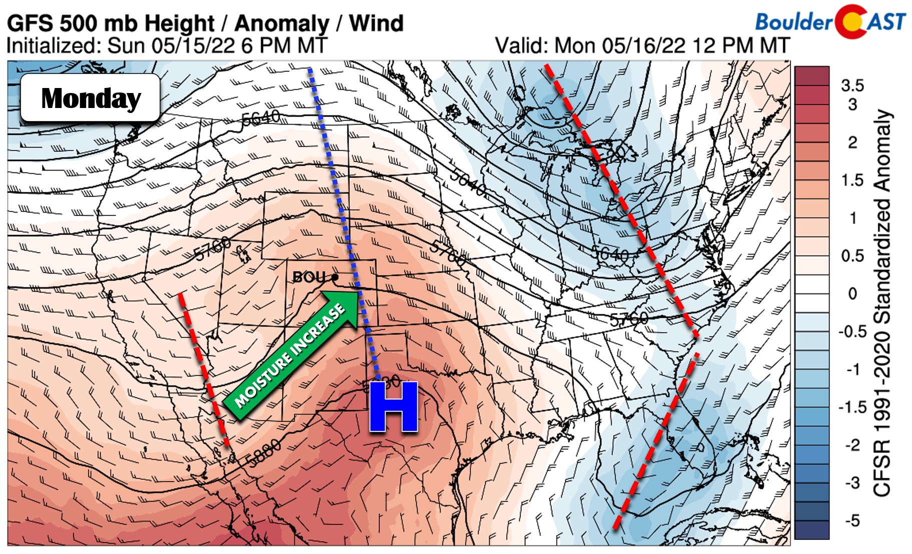
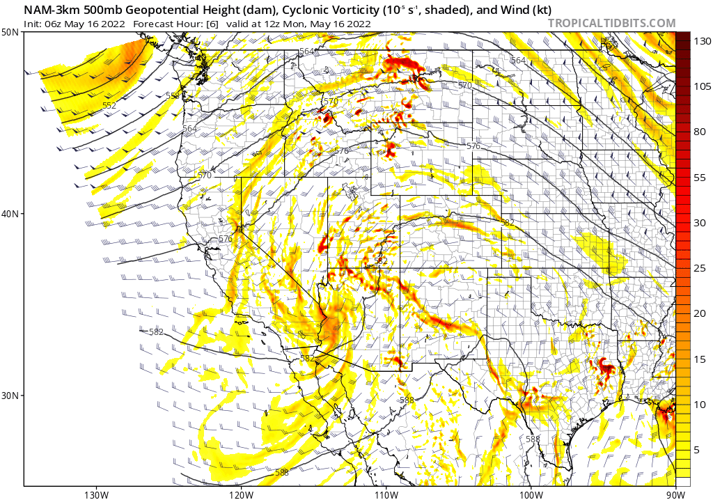
Continued west and southwest flow will facilitate a summer-like pattern for Colorado as moisture creeps up and daytime instability helps to fire off late-day showers and thunderstorms for the first half of the week. Interestingly, the west and southwest flow will contain handful of weak disturbances as well, seen in the 500mb vorticity forecast animation below as small dips and bumps in the height lines across the Four Corners region. The disturbances will help to slightly boost late-day storm development through Wednesday with the Front Range poised to see isolated to scattered rain chances each and every day. Woohoo!
CAPE, that is the convective energy available to produce thunderstorms, will be boosted to the highest levels we’ve seen thus far in 2022 this week — a clear indication that storms are on the way…
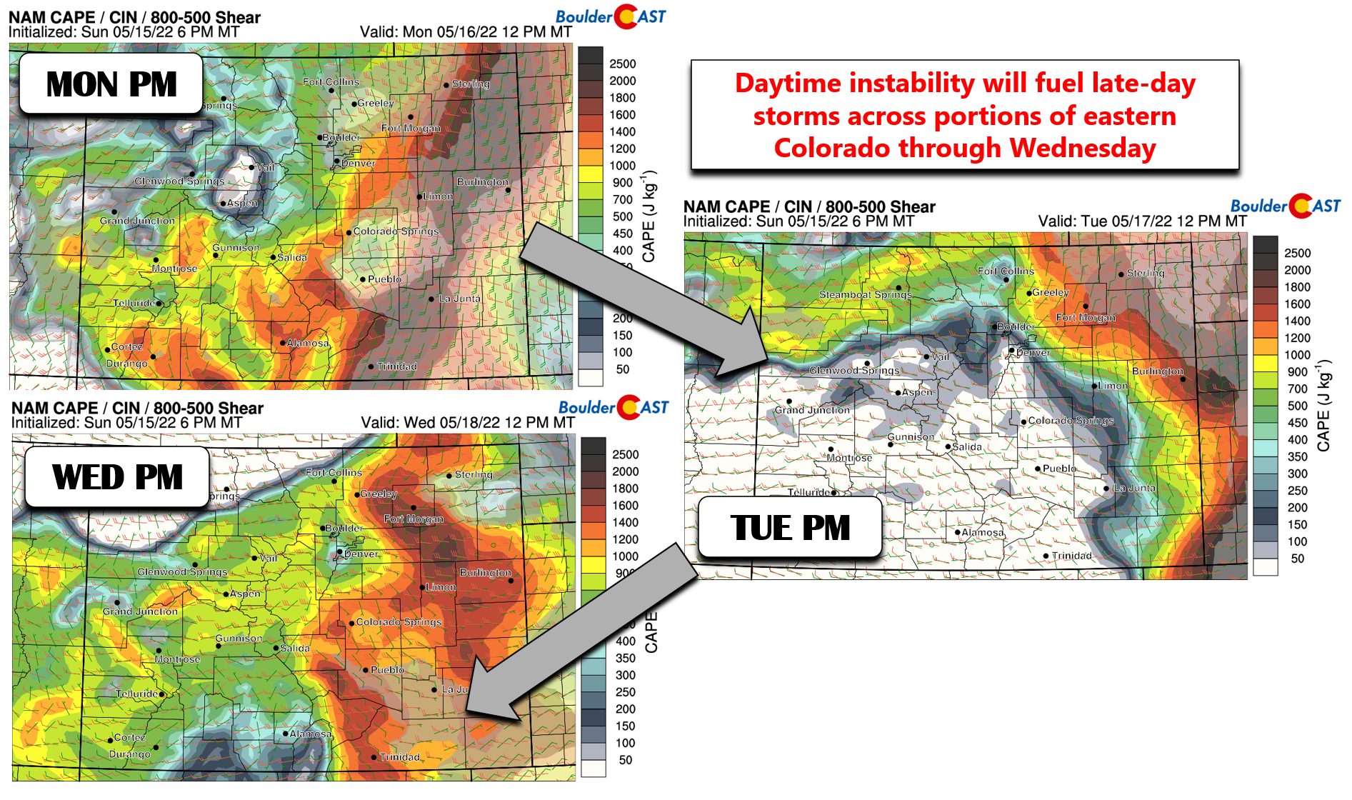
There are even are few situations where some shear will likely be present as well allowing for isolated strong to even severe thunderstorms to develop across eastern Colorado. As usual, though, the severe storm chances will generally be east, northeast, or southeast of the Denver Metro area through the week where moisture availability will be greatest. The latest convective outlooks from the Storm Prediction Center are shown below. Tuesday appears to be the most active day for high-impact storms, possibly even including portions of the eastern Denver area, but this could change. Again we believe the stronger storms will primarily be focused east of our area with little concern for Boulder proper.
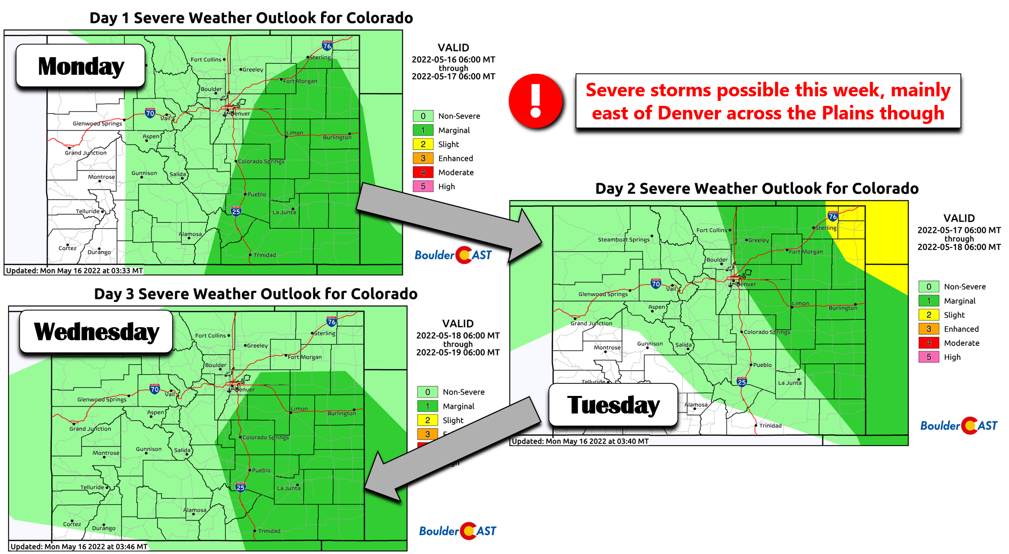
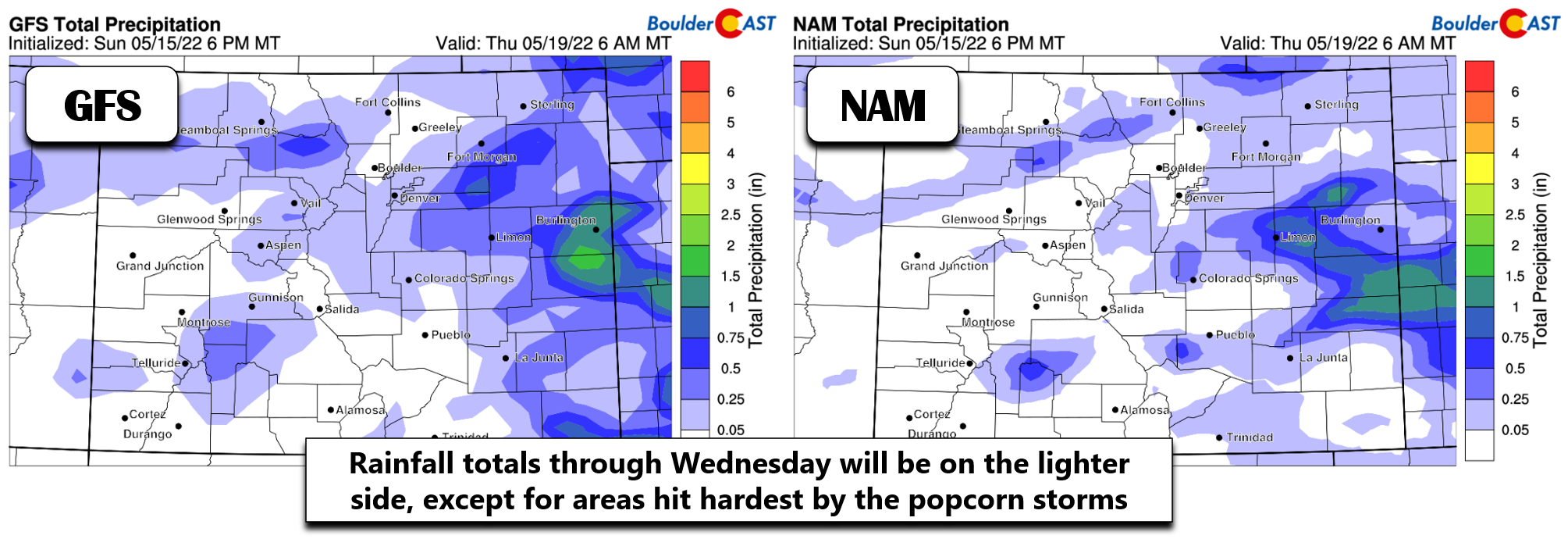
So where does this leave us? Well, for Monday through Wednesday, expect warm temperatures in the upper 70s to middle 80s with late-day storms rolling off the higher terrain — think conditions akin to a monsoon pattern. The storms could turn severe as they head east of Denver, but for our area they will be falling into a drier airmass leading to mainly light rainfall and gusty outflow winds up to 40 MPH.
Overall we are happy to see moisture returning to the forecast across the Front Range since it hasn’t rained in Boulder or Denver in about two weeks! However, this type of pattern isn’t one that generally produces the widespread, soaking precipitation that we desperately need to help with the ongoing drought. Outside of the most intense cells, storms this week won’t amount to much on the ground. That may change later in the week…
Fire danger precedes a snowstorm late in the week?
Late in the week the pattern begins to shift to one more favorable for precipitation across our area as a big, mid-latitude trough digs into the northern Rockies on Thursday. Models have been fairly consistent with the signal on this storm since the middle of last week, though the timeline and track keep shifting (as you know, this is normal). Initially as this storm approaches, hot and gusty conditions will take hold across our area on Thursday ramping up the fire danger. Red Flag Warnings are looking quite likely for much of eastern Colorado and portions of the High Country — plan ahead for that. Temperatures on Thursday will close in on 90 degrees across the area — this would be near-record territory for many Front Range cities. Things will then turn drastically colder and perhaps snowier for Friday as the main storm system moves in…
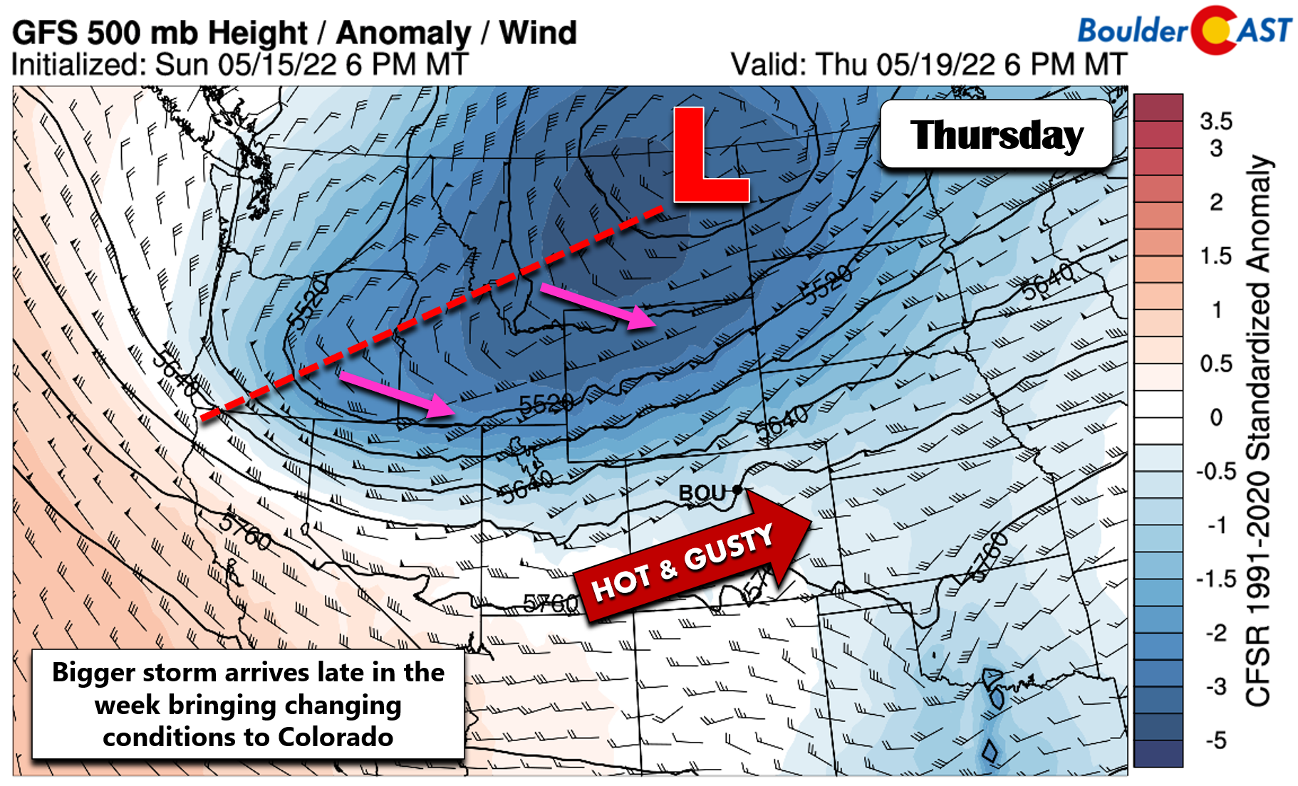
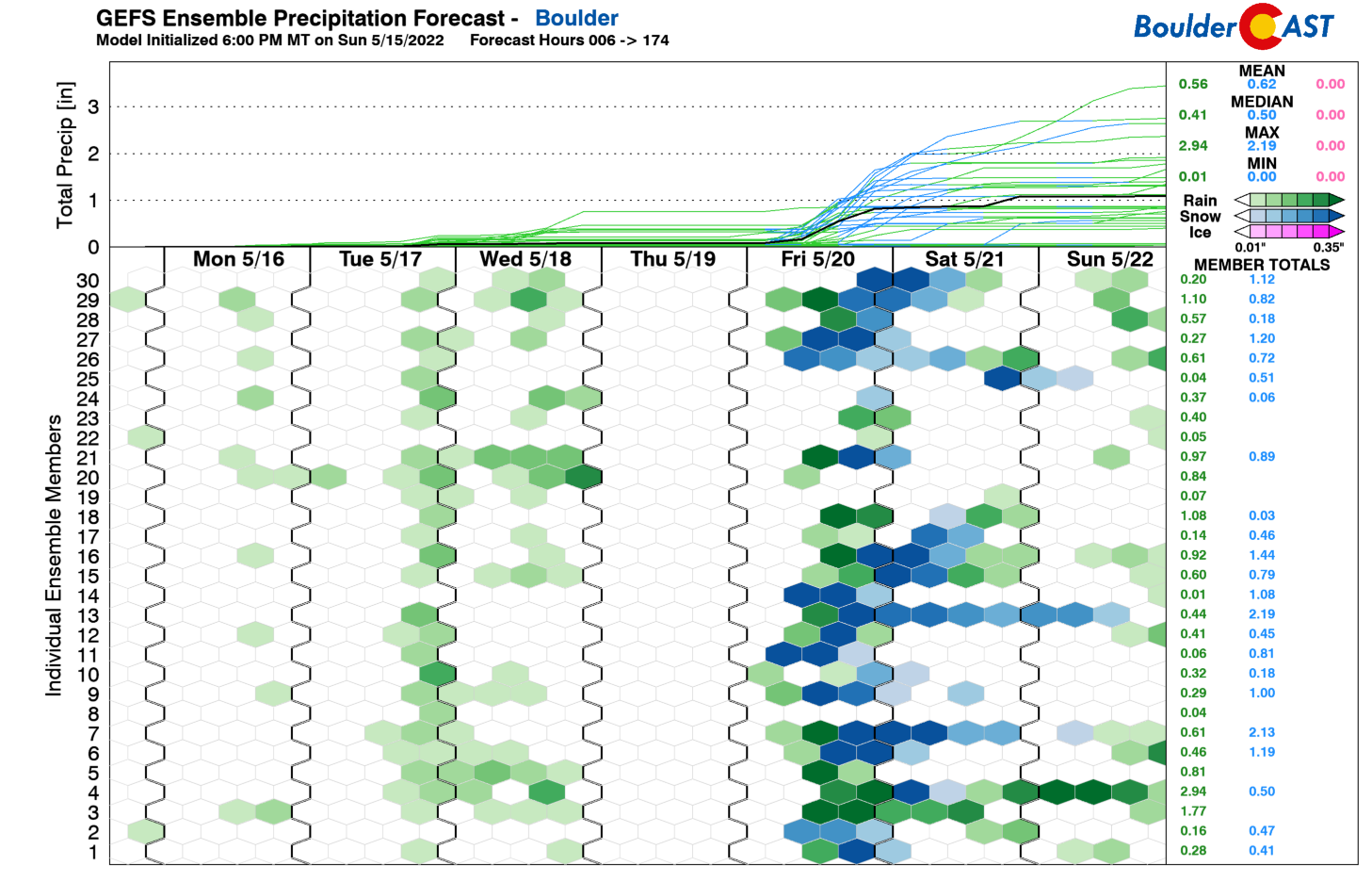
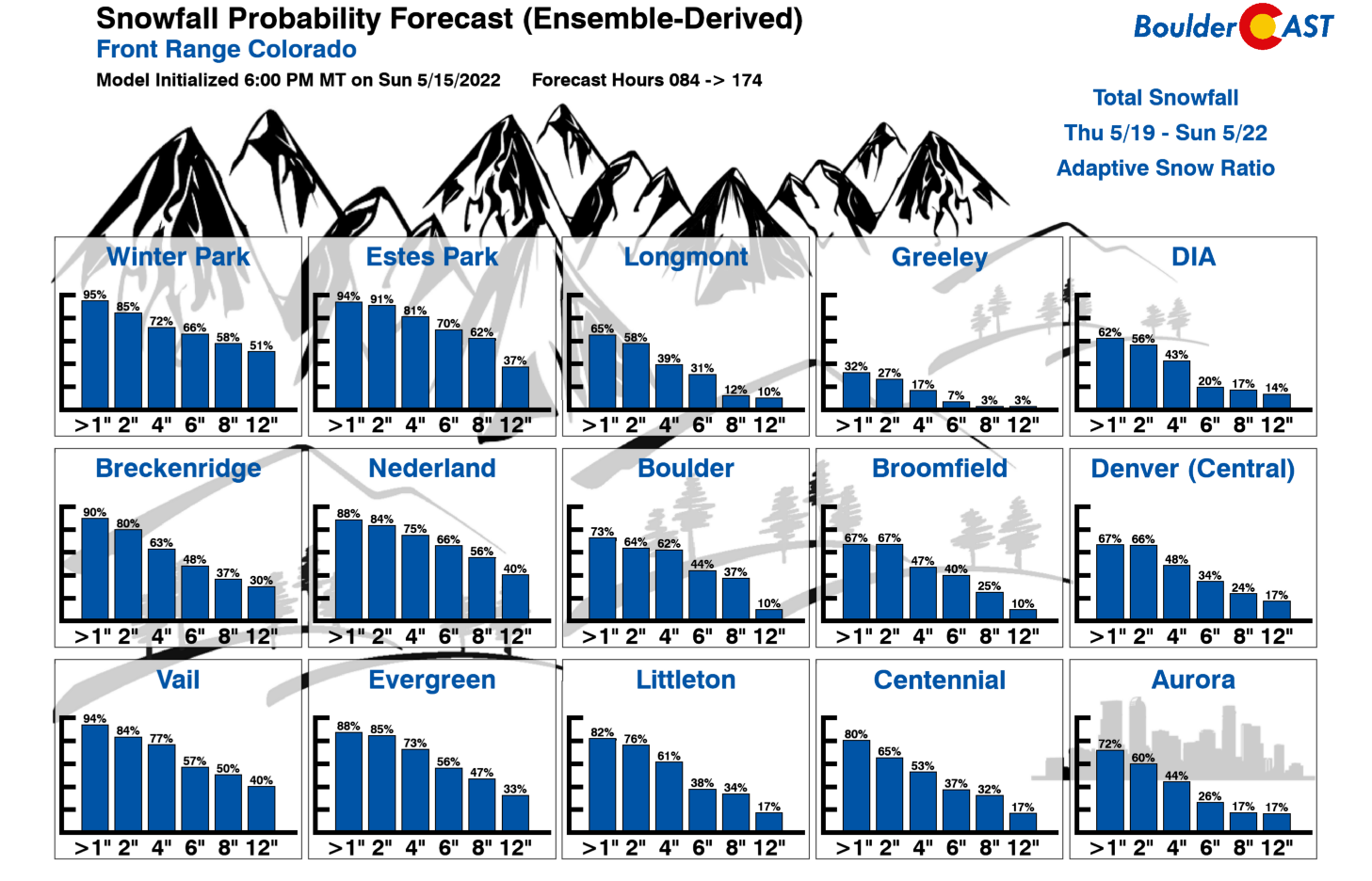
We’re seeing excellent model support for widespread upslope precipitation developing for areas east of the Continental Divide to end the week. If you believe the American GFS model suite, temperatures will be cold enough for a mainly snow event for even the lower elevations (yes we said snow)! The Euro model is not as optimistic for frozen precipitation, but still does have the chance of some light accumulations in both Boulder and Denver — quite incredible for this late in the snow season!
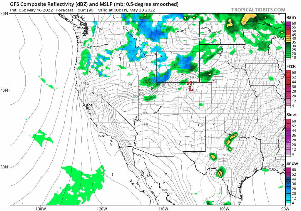
GFS precipitation and pressure forecast for Thursday into Saturday as rain/snow develop across the Front Range
It’s hard to believe, but temperatures on Friday will be nearly FIFTY degrees colder than Thursday! We’re expecting highs to land somewhere in the 40s with overcast skies and precipitation around through the day. Some of the colder model solutions like the GFS have highs only in the low to middle 30s! We’ll have to see how this system evolves through the week as it remains quite uncertain right now. The GFS is without doubt the more bullish and colder model at the moment — its ensemble mean has around 0.75″ of moisture for Boulder (with up to 2″ on the high end; see below). The GFS is producing around 2-6″ of snow! The Euro on the other hand is weaker with a mean around 0.3″ of moisture and generally less than 1″ of snow.
Here’s what we know so far and what to look out for as the storm approaches:
- A strong storm is poised to impact much of Colorado late in the week with drastically changing weather conditions
- On Thursday, temperatures will be near 90 degrees with gusty winds creating critical fire weather
- Much colder on Friday with rain/snow developing across the area — highs only in the 40s or even the 30s
- Several slushy inches of snow are possible even on the lower elevations, but not guaranteed at this point
- Temperatures could drop near or slightly below freezing at some point — keep a close eye on your garden, hoses and exposed pipes!
That’s all for now. Check back later in the week for updates on this potential wintry storm system…
Stay up to date with Colorado weather and get notified of our latest forecasts and storm updates:
Forecast Specifics:
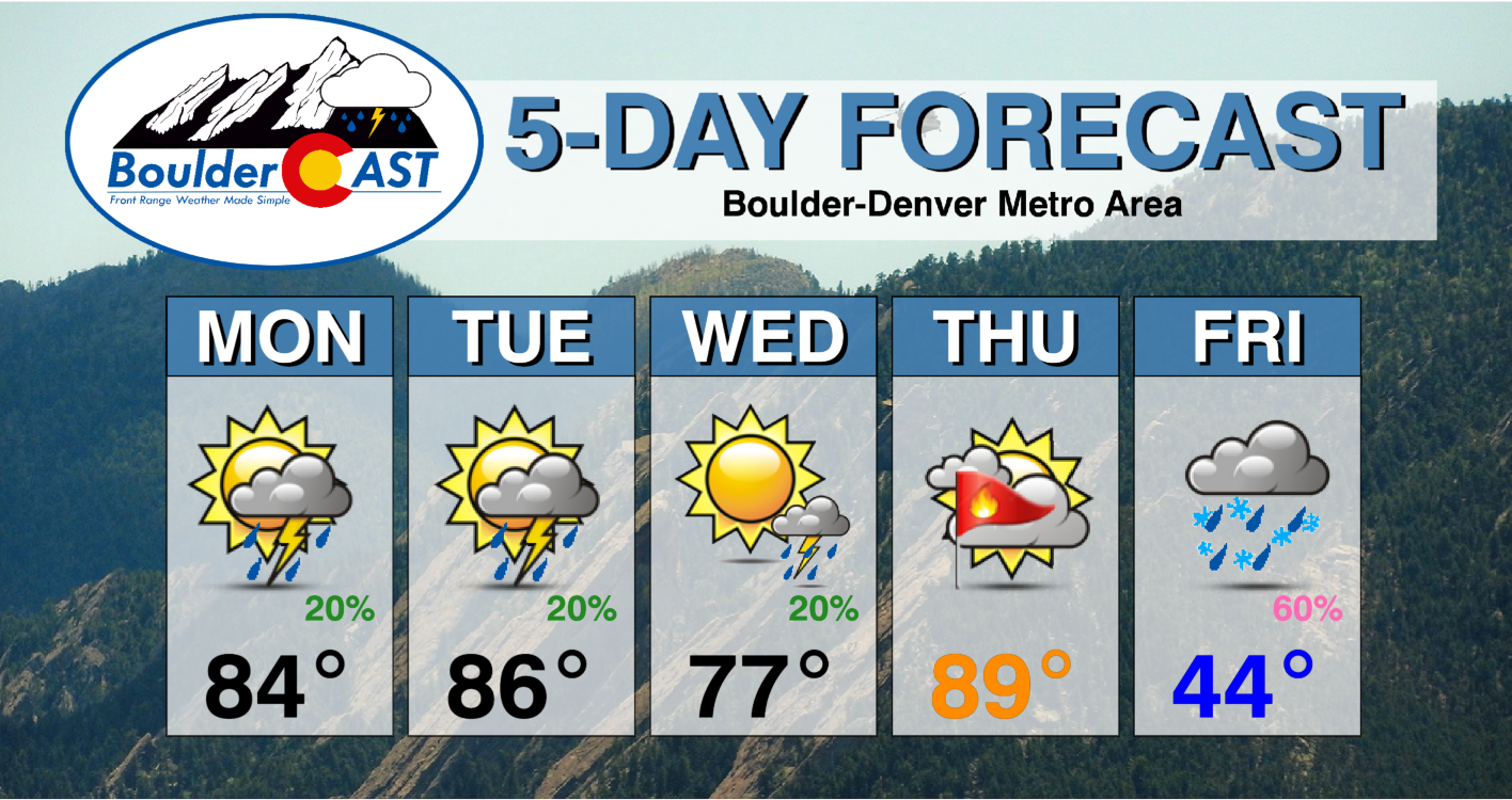
Monday: Partly to mostly cloudy with widely scattered late-day showers and thunderstorms moving off the higher terrain. Anything that develops could produce brief gusty outflow winds up to 40 MPH. Temperatures in the lower 80s across the Plains with upper 60s in the Foothills.
Tuesday: Partly cloudy skies with widely scattered afternoon and evening showers and thunderstorms. Some storms could turn severe east of Denver. Highs in the middle 80s on the Plains with lower 70s in the Foothills.
Wednesday: More sunshine but still a slight chance of late-day storms, some of which could turn severe east of Denver. Temperatures slightly cooler in the upper 70s across the Plains with upper 60s in the Foothills.
Thursday: Near-record high temperatures and breezy with high fire danger across the area. High temperatures soar to near 90 degrees on the Plains with middle 70s in the Foothills.
Friday: Remarkably colder and overcast with upslope rain and snow possible through the day. Highs in the 40s across the Plains with 30s in the Foothills. Accumulating snow is likely in the Foothills and also possible across the lower elevations. Keep an eye out for freezing temperatures during this period as well.
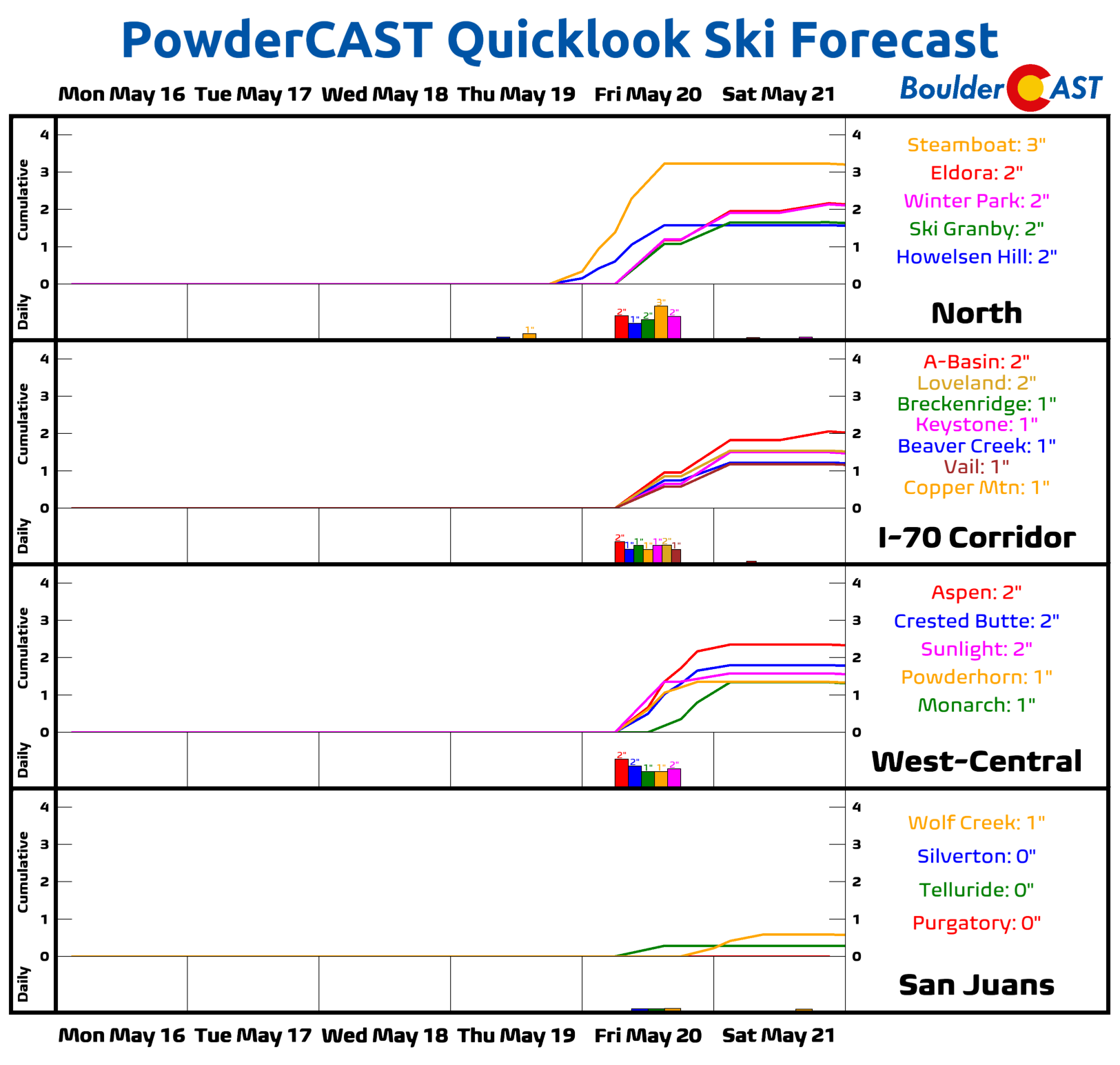
Mountains: Spotty thunderstorms will be possible in the Mountains this week through Wednesday — watch out for pockets of lightning. Thursday will be dry and windy with high fire danger. The late-week storm will mainly impact areas east of the Mountains, but a few inches of snow are possible for many ski resorts (although most of them are either partially or entirely closed at this point).
Help support our team of Front Range weather bloggers by joining BoulderCAST Premium. We talk Boulder and Denver weather every single day. Sign up now to get access to our daily forecast discussions each morning, complete six-day skiing and hiking forecasts powered by machine learning, first-class access to all our Colorado-centric high-resolution weather graphics, bonus storm updates and much more! Or not, we just appreciate your readership!
Spread the word, share the BoulderCAST forecast!


You must be logged in to post a comment.