
Compared to last week, the week ahead will feel like spring has sprung, at least if you stay below about 9,000 feet! Southwesterly flow will produce heavy mountain snow through Wednesday, alongside moderating temperatures for the lower elevations. We’re also tracking the potential for a couple nasty wind storms. Read on for our complete outlook of the upcoming week.
Tired of the cold?
The Arctic airmass that paraded in last Monday evening persisted throughout the week. The Plains remained entirely below freezing from 5PM Monday through 5AM Sunday, a total of 5 1/2 days. A stretch of sub-freezing weather this long only happens about once every year or two for the Metro Area.
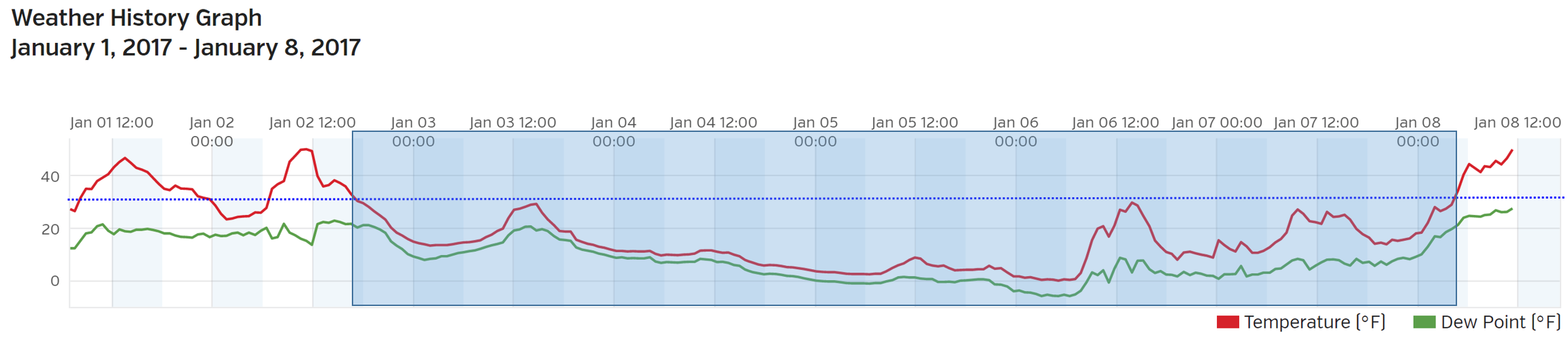
Time series of temperature from BoulderCAST Station over the last 7 days. The sub-freezing streak is boxed in blue.
During this time, Boulder set a new record low-high (lowest daily maximum temperature) on January 5th, reaching a peak of only 8 degrees (about 40 degrees below average). Alongside the bitter cold, significant snow fell, more than a foot in some spots. It’s probably safe to say we’re all ready for a warm-up!
Warmer down low, heavy snow up high
Our weather through mid-week will be driven by west southwesterly mid and upper-level flow across Colorado. The maps below show the 500 mb vorticity and winds for Monday (left) and Wednesday (right). Notice that there is also a general troughing pattern across the western United States as well, with numerous pieces of atmospheric energy embedded in the flow (patches of vorticity, i.e. the yellows and oranges).
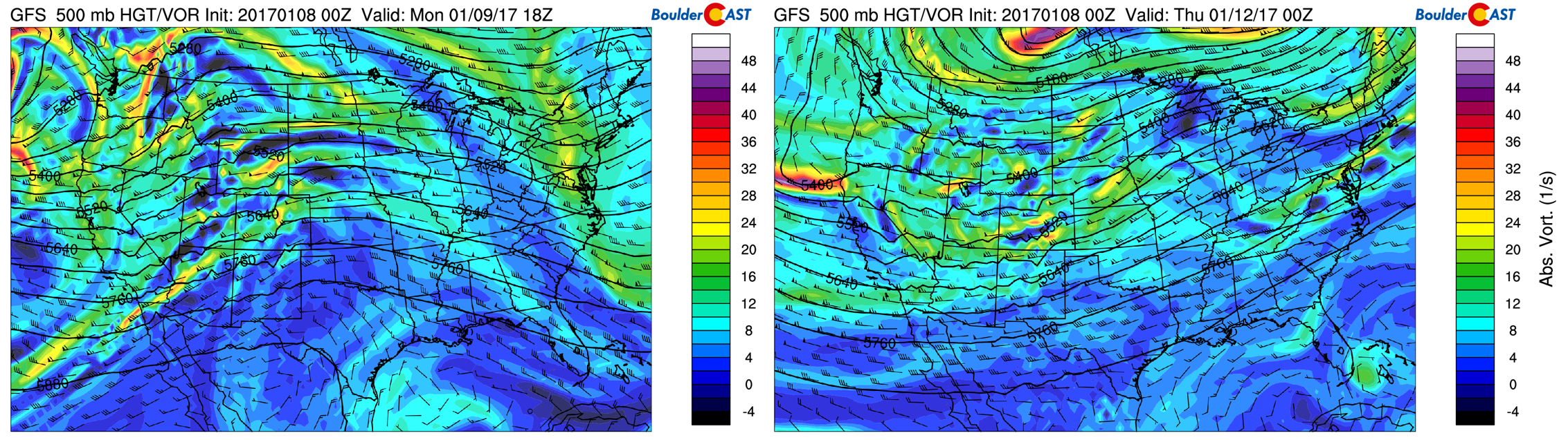
GFS 500 mb vorticity maps for Monday (left) and Wednesday (right).
Moisture content in the air is often elevated with southwesterly flow, and this week will be no exception. The moisture anomaly map below shows the first part of this week will be a classic atmospheric river set-up. We can trace the huge moisture anomaly over Colorado all the way back to the central Pacific Ocean south of Hawaii.
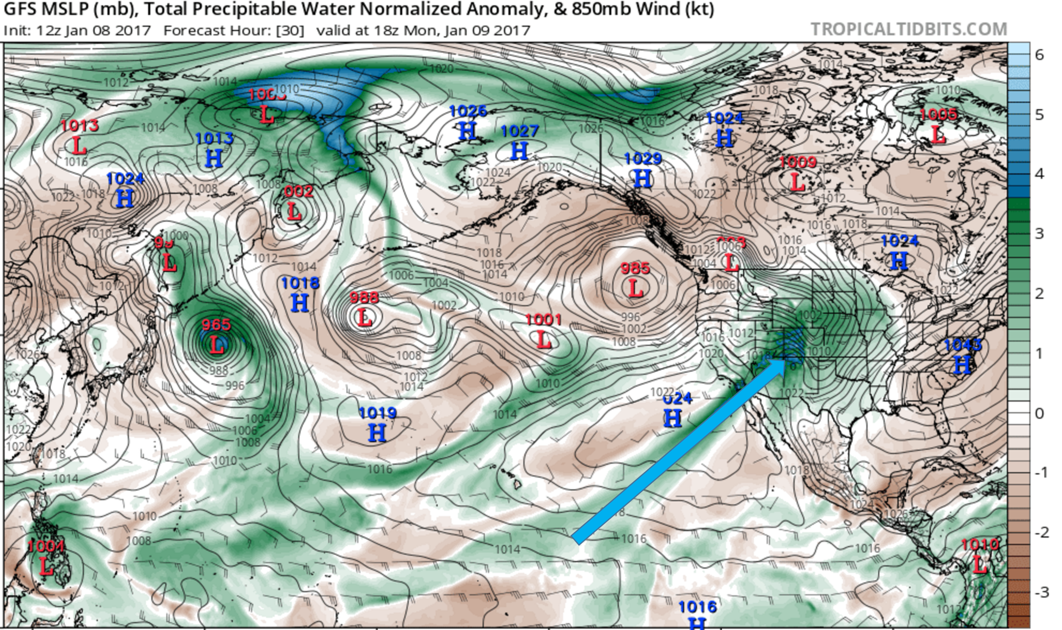
GFS pressure and moisture anomaly map for Monday, showing a plume of moisture with tropical origins heading into Colorado.
Copious amounts of moisture will combine with energy from the trough to produce heavy snow in the Mountains this week. Snow will be more-or-less continuous into Thursday, but there will be several time periods where heavier, more widespread snow will fall. One looks to be from late Monday morning into Tuesday morning, and another during the day Wednesday.
This is a very favorable set-up for mountain snow across the West, including Colorado. Though southwesterly flow tends to favor the San Juans for snow, the wind direction will fluctuate through the week. For this reason, all of Colorado’s Mountains should get in on the action. The powder will really add up…we’re talking several feet for most locations. The unlucky spots should break 12″, with the lucky ones possibly exceeding 3 feet by Thursday. You shouldn’t have much trouble finding the powder!
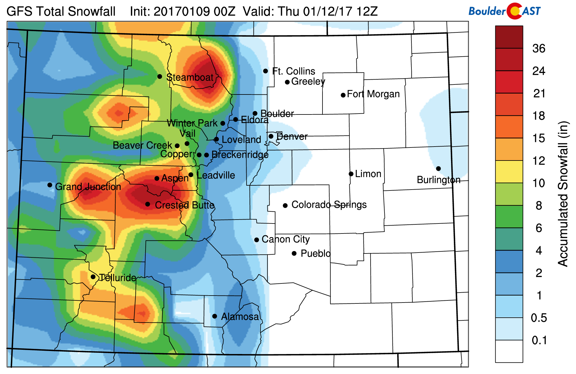
GFS snowfall forecast through Thursday. Big totals are possible in the High Country.
—
At the lower elevations, we’ll be benefiting in another way from the southwesterly flow: above normal temperatures! How warm are we talking? Monday will see temperatures climb to near 60 degrees, then near 50 on Tuesday and again for Wednesday.
There will be windy times as well, as models are in good agreement of two downslope wind storms early this week. The first comes early Monday morning into the afternoon. Winds will be sustained at 25 to 40 mph out of the west, with gusts exceeding 75 mph in and near the Foothills. The pressure map below for 5AM Monday shows the very strong gradient in place across the Front Range Foothills.
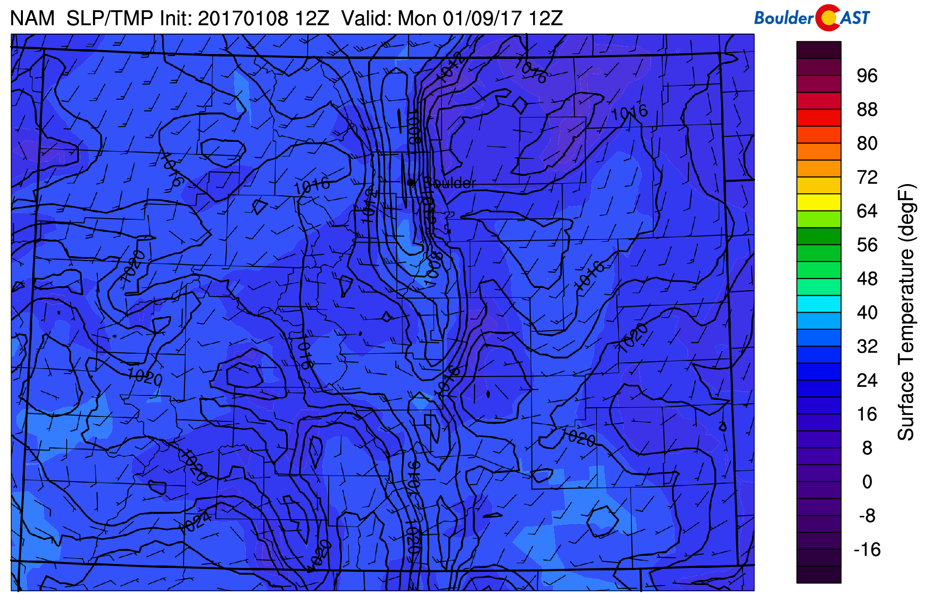
NAM sea-level pressure and surface temperature map at 5AM Monday, showing a strong pressure gradient across the Foothills.
On Tuesday, there is also indication of a more widespread, but weaker, wind event. Wind gusts could exceed 50 mph Tuesday evening and night across much of the Metro Area and Foothills.
As far as precipitation, there is so much moisture available, it wouldn’t be surprising if a few light showers spill over the Divide into the Metro area. We think the best chance of this happening would be from Monday afternoon through Tuesday afternoon. Though, anything that does survive the downslope will be light and not have much of an impact. Temperatures will be quite warm, so it will be rain, or a non-accumulating rain/snow mix. However, the Foothills, particularly above 8,500 feet along and west of Peak-to-Peak Highway could see several inches of snow through Wednesday.
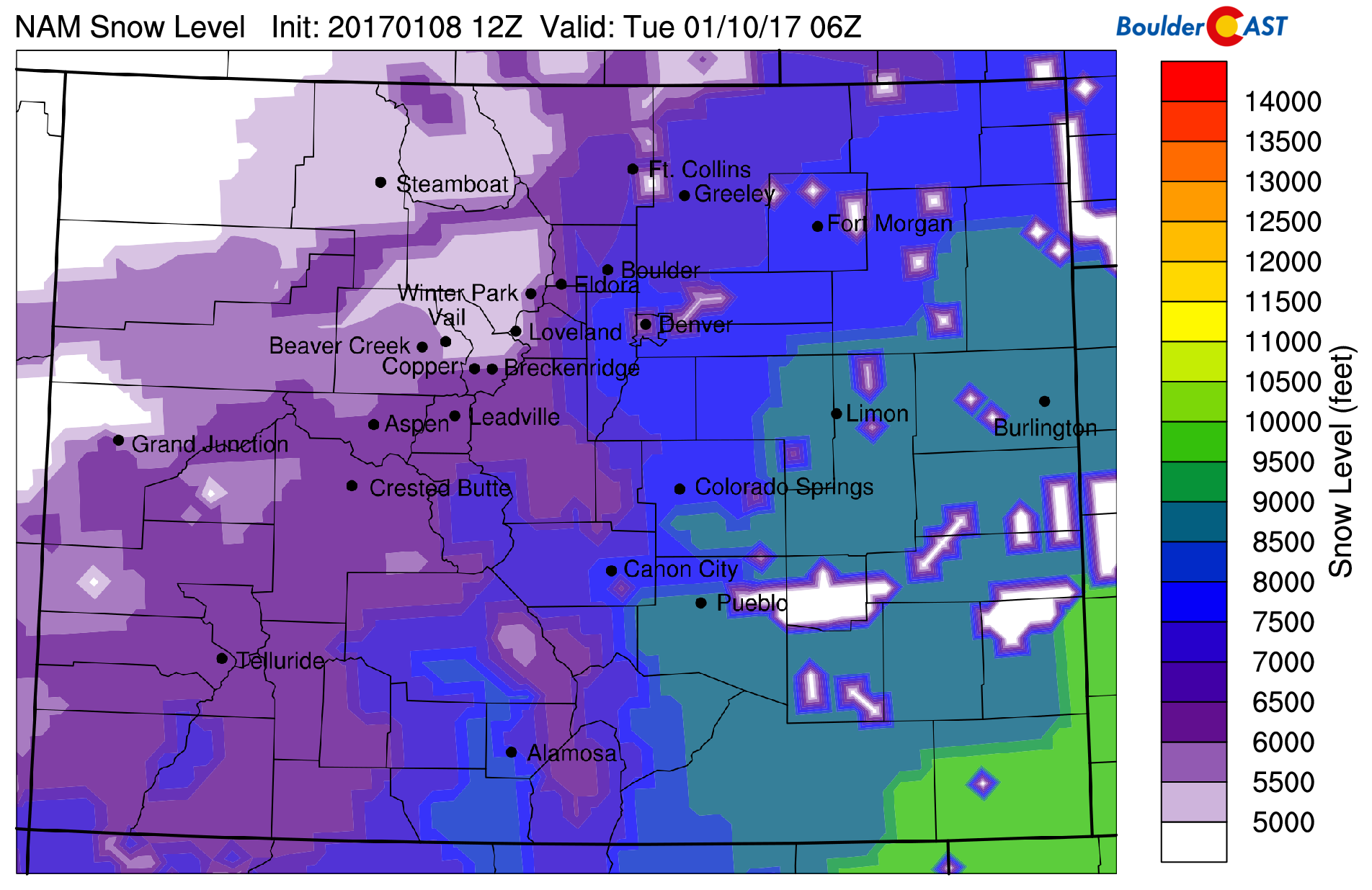
NAM forecast snow level for Monday night, showing the potential for snow levels to drop down to about 6,500 feet.
Uncertainty for the end of the week, but probably tame
By Thursday, a weather system will be coming ashore in California and probably cutting off from the jet into Arizona or northern Mexico. At the same time, another cold airmass, associated with a trough in central Canada, will be moving into the center of the country. The 500 mb map below for Thursday night shows both of these features.
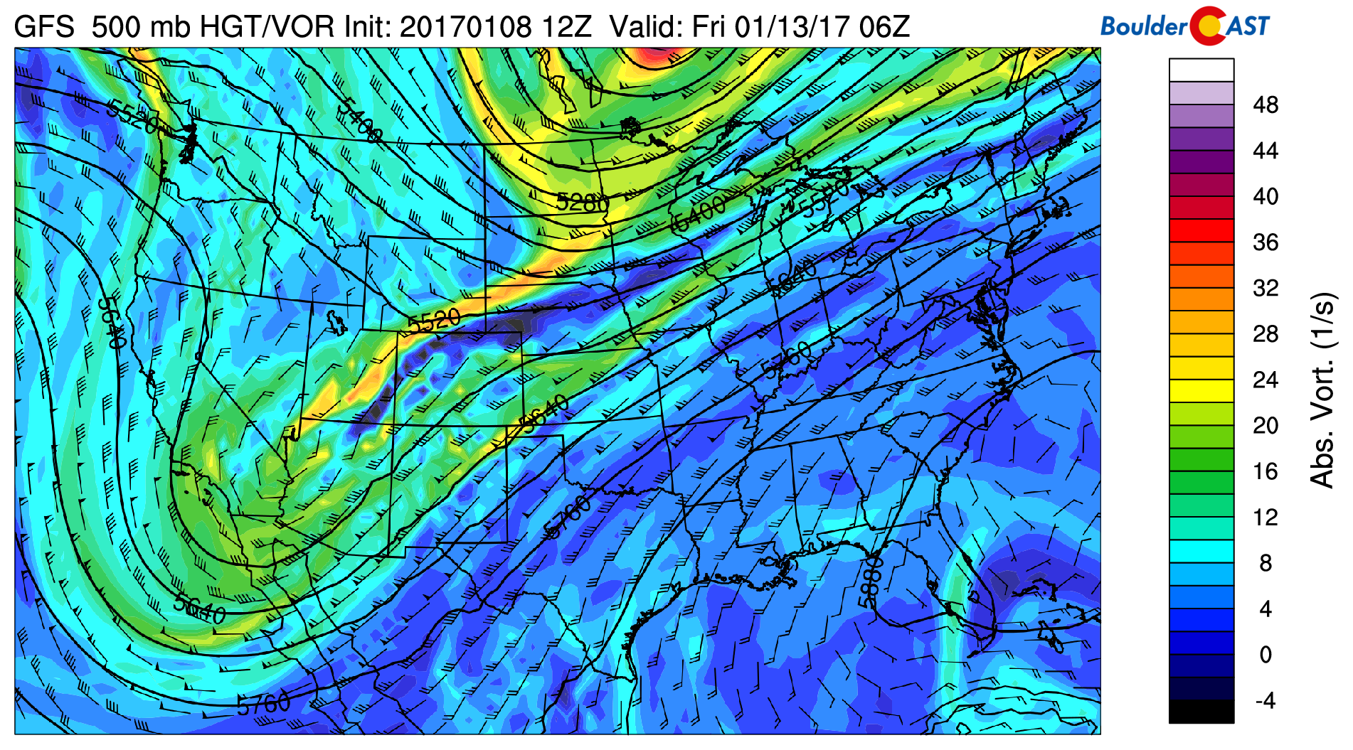
GFS 500 mb vorticity map for Thursday night, showing a cut-off system in southern California, and a trough in the upper-Midwest.
For us, the uncertainty lies in exactly how these two systems will impact each other. We’re not as much concerned about precipitation as we are temperatures. The progression and evolution of the southern system will ultimately determine how much of that cold air makes it into Denver, and when.
Some indication is that it could be as early as Wednesday night, or as late as Friday morning. The surface temperature map below shows the strong gradient across the front Wednesday afternoon…50’s in Denver, below freezing in the northeast corner of Colorado.
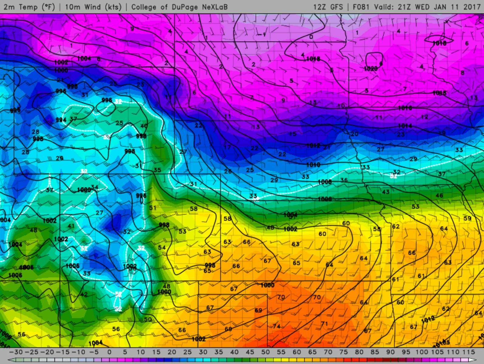
GFS surface temperature and wind map for Wednesday afternoon. It looks like Denver will be warm, but cold is looming to the northeast.
Let’s say for now that front arrives Thursday morning. This will bring sharply colder temperatures in the 40’s or 30’s. Depending on how far the cold air pushes, Friday will then be in the 20’s or 30’s. We also won’t rule some light snow on the backside off the front, but we’re not expecting anything significant at this point.
Mountain snow will also likely be present in some capacity Thursday and Friday, but it should be lighter than that earlier in the week, and may be focused on southwest Colorado.
As always, we’ll keep you updated if things change. Though, we reckon chances of that are far below what transpired last week. Let the melt begin!
Forecast Specifics:
Monday: Cloudy and windy with a slight chance of evening showers in and near the Foothills. It will be all rain on the Plains, with a rain/snow mix in the Foothills. 2 to 5″ of snow is possible along Peak to Peak Highway Monday afternoon into Tuesday. Winds will be strongest in the morning, with gusts exceeding 75 mph possible. Winds should relax after sunset. Highs near 60 on the Plains with 40’s in the Foothills.
Tuesday: Partly to mostly cloudy and windy again with a slight chance of a few isolated rain/snow showers during the morning in and near the Foothills. Winds will be strongest during the evening and overnight, with gusts potentially exceeding 55 mph. High temperatures in the low 50’s across the Plains, with upper 30’s in the Foothills.
Wednesday: Partly sunny and breezy. Dry for the lower elevations, with a slight chance of rain/snow in the Foothills. Little additional accumulation is expected. Temperatures in the low 50’s across the Plains, with upper 30’s in the Foothills.
Thursday: Increasing clouds and cooler following the passage of a cold front. There will be a slight chance of snow showers. Expect highs early in the day to range from 35 to 45 degrees, depending on how the front timing evolves this week.
Friday: A mix of clouds and sun. Probably the coldest day of the week with highs for the Plains in the 20’s, with teens in the Foothills. There is too much uncertainty to rule out a slight chance of snow this day either, particularly in the morning.
High Country: Powder is the word this week as significant snow will dump on the Mountains. While snow is possible most days this week, widespread heavy snow will come in two waves…the first Monday morning into Tuesday morning, and the second during the day Wednesday. One to three feet of snow will be common through Thursday. Snow chances diminish Thursday and should cease during the second half of Friday..
Extended: The extended outlook shows moderating temperatures this weekend as downslope erodes that cold airmass. We could be returning into the 40’s and 50’s. This warming trend looks to continue right into next week. We’re not seeing much indication for snow in the pipeline for the lower elevations.
Mon
Tue
Wed
Thu
Fri


Temperature
59
50
50
39
29


Precip Chc (Plains)
10%(pm)
10%(am)
0%
10%
10%


You must be logged in to post a comment.