
Following a quick shift back to winter-like temperatures this weekend, warmth will return this week alongside peaceful weather as a ridge slowly slides across the state. Will the powerful downslope winds accompany the warming this week? Read on to find out.
Let’s quickly revisit the record warmth from last week. Six out the last seven days in Boulder have been above sixty degrees. Quite impressive for early February. The craziest day, Friday February 10th, began with a downslope wind storm in and near the Foothills. Early morning power outages in Boulder were the result of gusts exceeding 80 mph in parts of the city. As winds relaxed during the afternoon, records began to shatter across the region as temperatures climbed into the mid and upper 70’s.
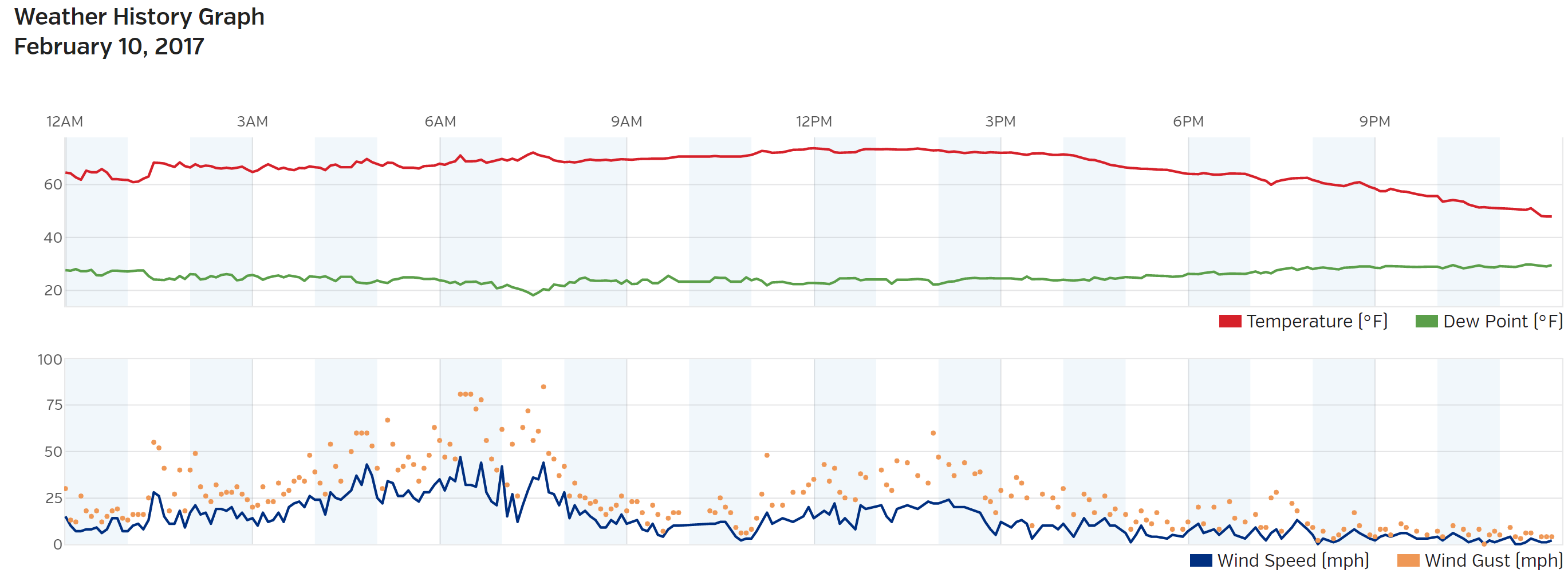
Temperature and wind graph from BoulderCAST Station on 2/10/17. Notice the nearly constant temperatures at or above 70 degrees much of the day, and wind gusts exceeding 80 mph during the morning hours
Denver International Airport even hit 80 degrees, the warmest temperature ever recorded during the month! Furthermore, this is the first 80-degree day to occur during meteorological winter in the city’s history (December-January-February). Boulder set a daily record, *only* reaching 76 degrees. It truly felt like Spring before a cold front Saturday morning brought us back to the reality that it is indeed still winter!
Southern storm will miss Denver
Early on in the week, a cut-off system will track well to our south bringing rain and snow to southern Colorado and New Mexico. The 500 mb vorticity map below for Monday afternoon shows the center of the system tracking along the United States/Mexico border. Winter Storm Warnings are already posted for New Mexico and parts of Texas.
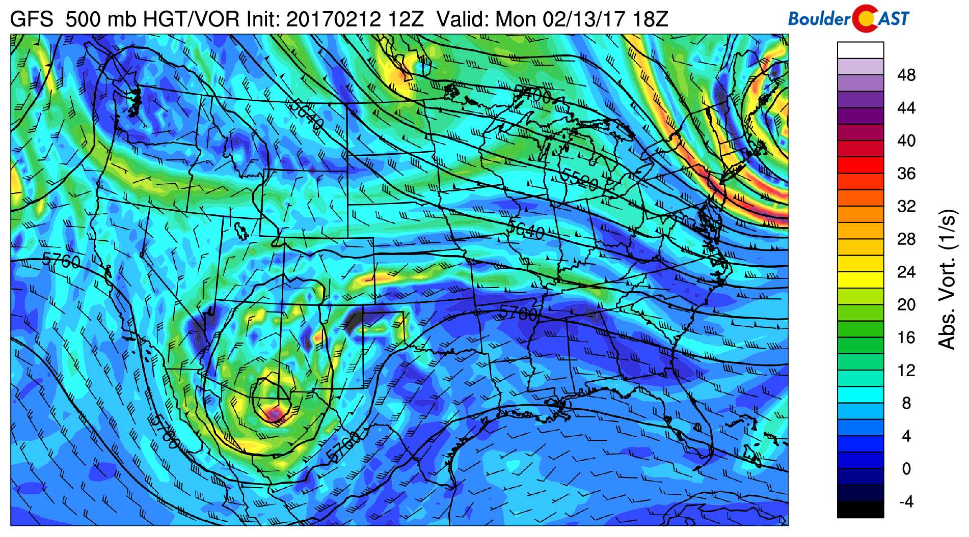
GFS 500 mb vorticity map for Monday afternoon
In northern Colorado, weak troughing and northerly flow are visible. Not much forcing is present at all and therefore dry conditions will remain for our region. The total accumulated precipitation map through Tuesday afternoon shows some precipitation across extreme southern Colorado, but nothing in Denver.
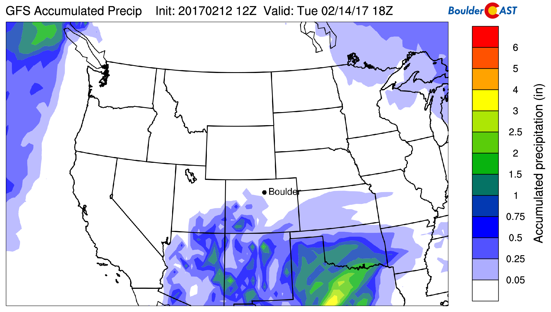
GFS total accumulated precipitation through Tuesday afternoon. The early weak storm will miss Denver well to the south.
With this northerly flow and troughing, temperatures will remain cool Monday (near 50 degrees), with slight warming by Tuesday into the middle 50’s.
Warming up by mid-week
As mentioned, warmth is set to return, but it will be hard to top last week for sure. The 500 mb map below for Wednesday shows a large ridge building in across the northern Rockies.
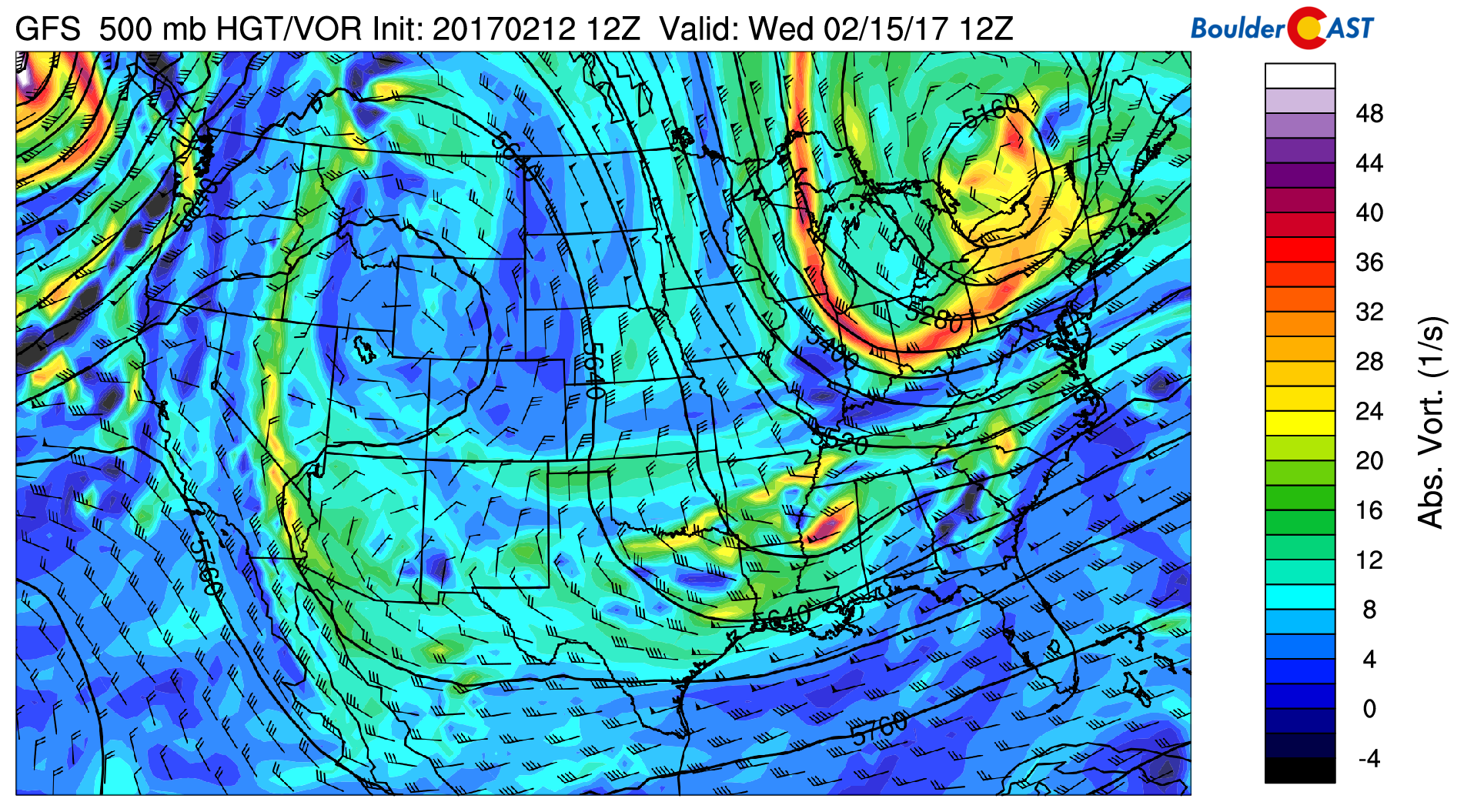
GFS 500 mb vorticity map for Wednesday morning
The ridge will allow a warmer airmass to invade the state bringing a return of the 60’s by mid-week. We’re thinking middle 60’s Wednesday, and then low 70’s on Thursday for now (this would approach record values). There will be full sunshine both days as well. This pattern differs from the downslope set-up we experienced last week where the jet was overhead. Therefore, unlike last week, winds should remain relatively calm during this “heat wave”.
By Friday, the ridge is already tracking eastward. The 500 mb map below for Friday morning shows a plethora of turbulent weather to our west.
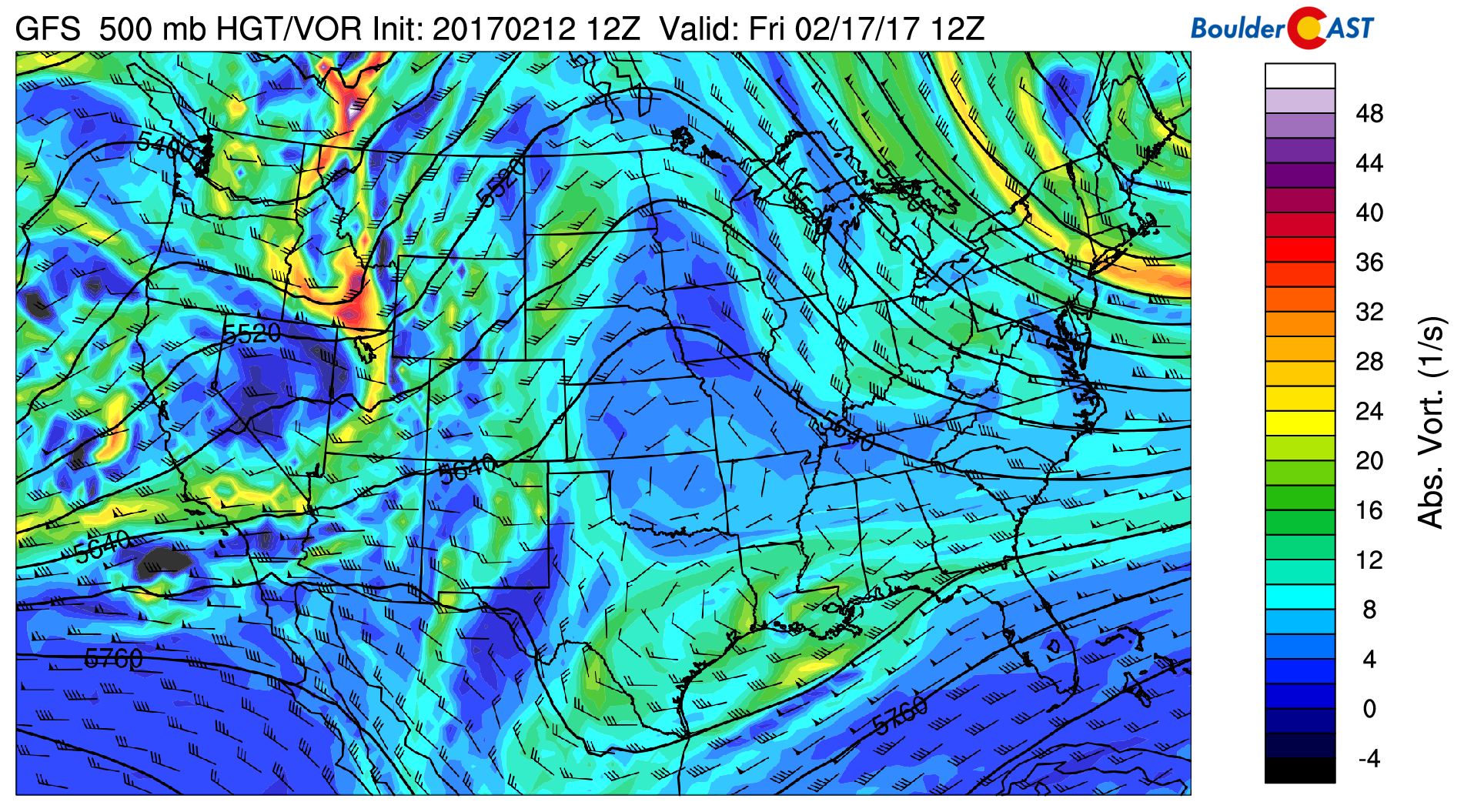
GFS 500 mb vorticity map for Friday morning
While the lower elevations will probably see another warm and dry day Friday, the chance of light snow will be spreading into the Mountains of western Colorado through the day. A few inches my be possible in locations favored by southwest flow. Boulder and Denver should once again be in the 60’s and remain dry, but finally see some clouds move in during the day. A cool-down is currently set to arrive Friday night, but the exact timing and strength is not set in stone this far out. Though, it appears above normal temperatures will continue right through the weekend (and much of next week, if the ensembles verify).
The GFS forecast 3-hourly precipitation map below for Friday evening shows the light snow in western Colorado. You will also notice a southern track system which could potentially bring heavy rain and snow to southern California and Arizona this weekend.
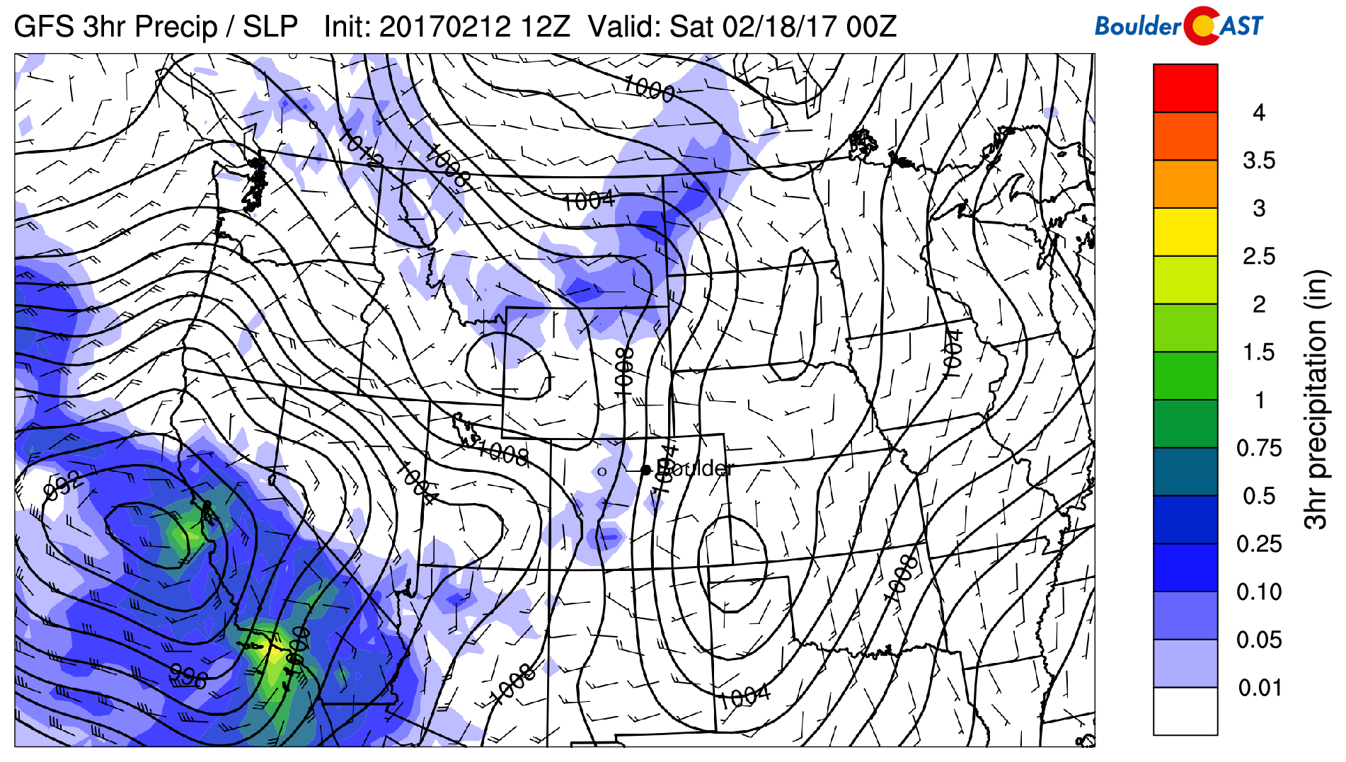
GFS 3-hour precipitation and sea-level pressure for Friday evening
We’ll definitely be keeping an eye on that southern-track system as it approaches Colorado. Western and southwestern Colorado look to be favored at this point for snowfall, but it’s a little early to say for sure. With the right track and dynamics, snow could make a return to Denver as well. This seems unlikely though.
Once again, enjoy the sweet taste of spring this week!
Forecast Specifics:
Monday: Mostly cloudy and seasonal with highs near 50 across the Plains and in the upper 30’s in the Foothills.
Tuesday: Morning clouds will give way to abundant afternoon sunshine. Temperatures will moderate as well. Expect highs in the mid 50’s for the Plains and in the low 40’s in the Foothills.
Wednesday: Sunny and warm with highs in the middle 60’s on the Plains. In the Foothills, temperatures will be in the low 50’s.
Thursday: Sunny and even warmer, likely exceeding record values for the date. Highs will climb into the low 70’s for the lower elevations, with upper 50’s in the Foothills.
Friday: Increasing clouds and still quite warm. Highs will be in the 60’s for the Plains and in the 50’s for the Foothills. However, uncertainty in temperatures is elevated as a system will be approaching with an associated cold front.
High Country: Light snow in southern Colorado, particularly in the San Juans, will take place during the day Monday, with 3-6″ possible. Dry and sunny conditions take over from Tuesday morning into Friday morning. At this point, a series of storms looks to move across the state right through the upcoming weekend. Many of the ski resorts could pick up sizable snow by early next week.
Mon
Tue
Wed
Thu
Fri


Temperature
50
55
64
71
66


Precip Chc (Plains)
0%
0%
0%
0%
0%


A question regarding Friday’s high winds. We live in the foothills just west of Boulder and numerous Ponderosa pines were sheared in half about 30′ above ground level. The location of these trees were in small clusters (1-4) and the top halves always blew to the south.
Given the sporadic distribution of these downed trees and the manner in which they were felled (none were toppled at roots as typical for high winds), do you have any thoughts on the type of winds that caused these tree sheerings?
Hmm. Very interesting observation, Patrick! It sounds like the critical threshold of wind speed that can snap trees in half was met (about 95 mph –> https://journals.aps.org/pre/abstract/10.1103/PhysRevE.93.023001). Winds decrease rapidly as you approach the ground (see log-wind profile), so its likely the 95 mph cut-off was up at about 30 feet, with slower winds towards the surface. This wasn’t a particularly intense windstorm, and it was short-lived, so maybe not enough net force was present down low to actually topple the trees.
The sporadic nature of the tree shearing is interesting. I am not sure what could cause such fine scale wind bursts. Possibly topography, but that wouldn’t be on the scale of tens of meters. Maybe just atmospheric eddies mixing the 95+ mph winds down in spots. I suspect the shearing threshold was borderline and it only came into contact with trees in isolated locations. During strong wind storms, 100+ mph gusts are more widespread and probably topple more trees.