Change is on the way! Unseasonably warm temperatures will continue across the Front Range for a few more days leading up to a significant pattern shift later this week. A series of cold fronts will impact the area in the days to come, knocking our high temperatures from the 80s on Monday into the 40s by Friday, though precipitation looks scant during this timeframe. However, the first Arctic blast of the season is taking shape for the upcoming weekend with temperatures set to plummet further alongside our first potential snowfall of the season. It’s about time!
This week’s highlights include:
- Despite an unsettled split-flow pattern across the West, Colorado weather will remain quiet for the first half of the week
- Our “second summer” continues for a few more days with highs in the 70s to lower 80s through mid-week
- An autumn cold front arrives Thursday with much cooler temperatures and a chance of drizzle to follow for Friday
- The first Arctic blast of the season is on-track for the upcoming weekend but the timing is uncertain — it will offer a chance of snow for everyone, albeit probably not much snow
- Highs fall near (or below) freezing Sunday and Monday with overnight lows in the lower 20s or even the teens — a definite hard freeze is inbound for all!
DISCLAIMER: This weekly outlook forecast is created Monday morning and covers the entire upcoming week. Accuracy will decrease as the week progresses as this post is NOT updated. To receive daily updated forecasts from our team, among many other perks, subscribe to BoulderCAST Premium.

Go Premium, get all the perks.
Daily Forecast Updates
Get our daily forecast discussion every morning delivered to your inbox.
All Our Model Data
Access to all our Colorado-centric high-resolution weather model graphics. Seriously — every one!
Ski & Hiking Forecasts
6-day forecasts for all the Colorado ski resorts, plus more than 120 hiking trails, including every 14er.
Smoke Forecasts
Wildfire smoke concentration predictions up to 72 hours into the future.
Exclusive Content
Weekend outlooks every Thursday, bonus storm updates, historical data and much more!
No Advertisements
Enjoy ad-free viewing on the entire site.
“Second summer” continues
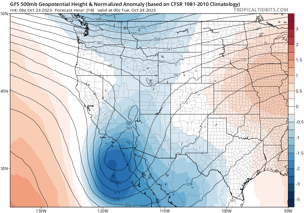
After tying or setting two daily record high temperatures last week in Boulder and Denver, the unseasonably warm autumn weather will continue for the first several days of this week as well. As of writing Monday morning, a split-flow type of pattern has developed across the Rockies with the main weather feature being the developing cut-off low over southern California. This low pressure will continue to navigate further southward into Mexico, largely bypassing Colorado to the south over the next few days. Further north, the primary mid-latitude storm track resides along the Canadian border. While initially there is only the faintest shortwave present on Monday passing across Montana and the Dakotas, this storm track will supply a stronger trough later in the week which will have big impacts on our temperatures here in the Front Range, as well as likely generating the first snowfall of the season. More on that exciting wintry news in a moment!

A look at GOES-East infrared satellite imagery on Monday morning shows the split-flow pattern over the West right now. Unfortunately Colorado will end up in the “split” portion of the regime with largely tranquil conditions as the best lift early in the week misses us both to the north and to the south. Talk about bad luck!

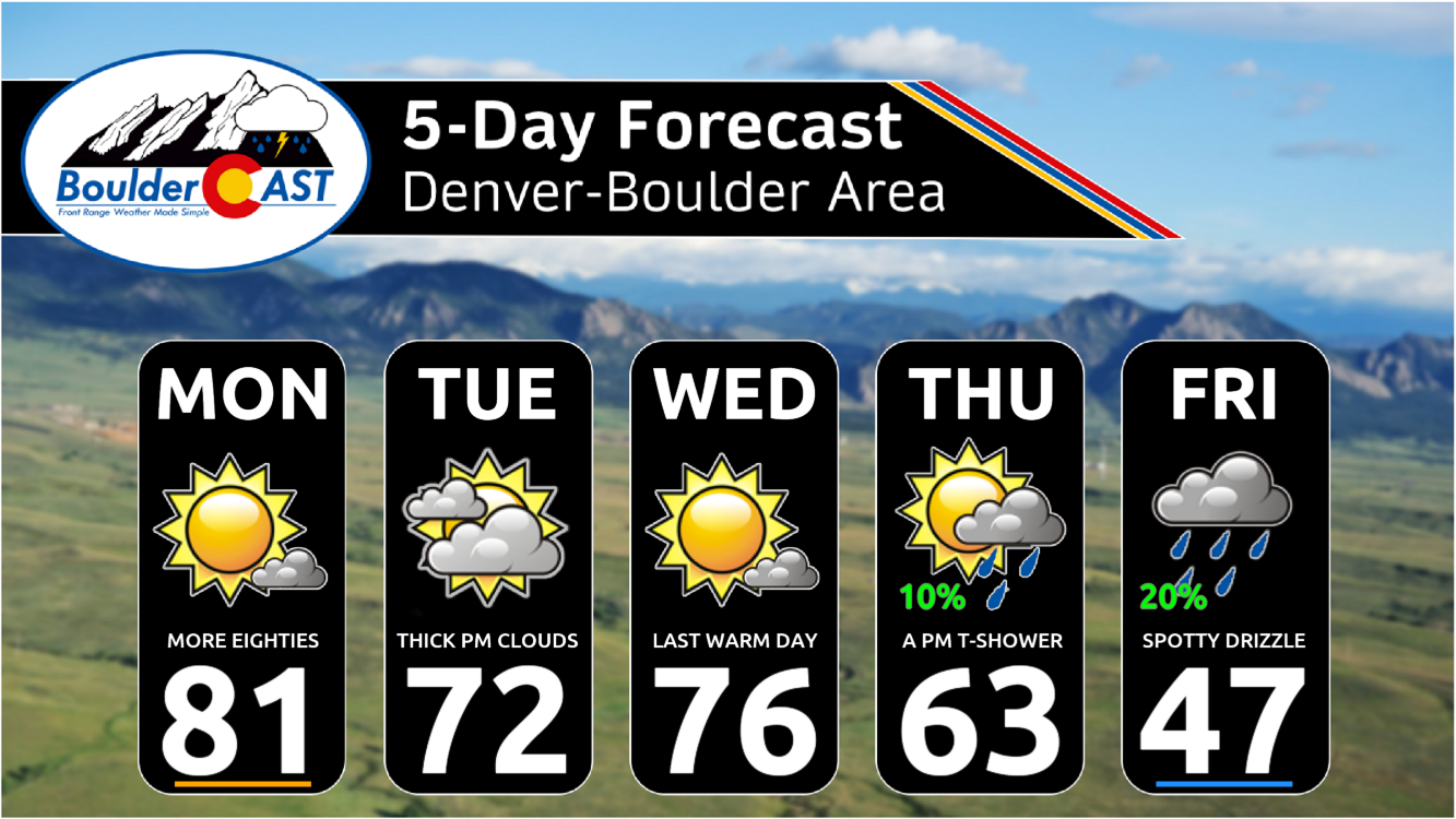
With this, we expect continued very warm temperatures on Monday under southwest flow with highs pushing close to 80 degrees across the lower elevations.
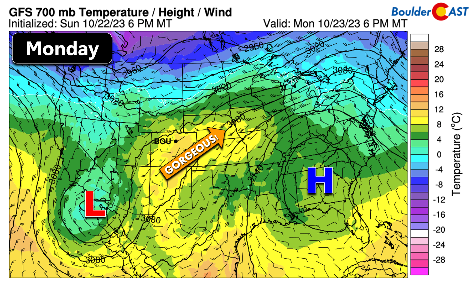
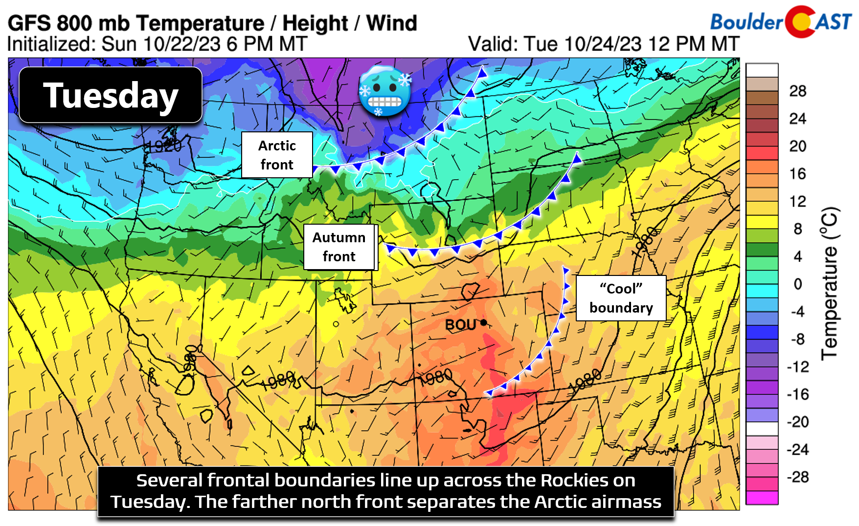
A weak cool front associated with that northern-tier shortwave will move through our area Monday night into early Tuesday injecting slightly cooler temperatures. At the 700mb level (~10k feet elevation), we are seeing about 3 to 4°C of cooling on Tuesday compared to Monday. This should translate to highs falling back into the lower 70s. While certainly cooler in comparison, this is still some 10 to 15°F above normal for late October — we should only be near 60°F right about now. Yet another case of a cold front not doing its one job!

Turning more unsettled & cooler later in the week
As we head into Wednesday, that southern-track low pressure will kick northeastward out of Mexico and pass into the Great Plains states, possibly clipping parts of eastern Colorado in the process. Latest model trends mostly keep all of the lift with this system east of our area, save for an increase in clouds on Tuesday well ahead of it and possibly a rogue thundershower or two clipping the area on Thursday as it fully passes. Overall, we expected mostly quiet and dry conditions through Thursday, despite some nearby weather features. High temperatures will stay unseasonably warm here, topping out in the middle 70s on Wednesday before falling off some by Thursday. We are seeing some signs for a sneaky frontal boundary being stalled out in the vicinity of our area on Thursday which leaves us with some uncertainty on the table in regards to our temperatures. North of the front highs may only be in the 50s, while to the south they will be well into the 70s. For now, we’ll go with high temperatures somewhere in the middle near 60 to 65°F Thursday, but just be aware it could swing up or down depending on where that front ends up…
This week, the first Arctic airmass of the season will finally ooze southward into the United States from Canada but its progress will be slow. Initially this very cold air will get stuck up in Montana on Tuesday (see below north of the Arctic front). There isn’t quite enough going on across the West to pull it any further south right away.
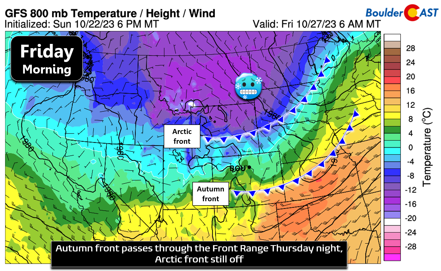
However, a trough entering the Pacific Northwest late in the week should do the trick to nudge the cooler air into our area, though just how cold it will get and when remains somewhat murky. We know that the bottom will begin to fall out Thursday night with an initial autumn front blowing through. It’s unclear if there will be enough moisture to generate any precipitation behind this front, but there certainly could be some. For now it looks like Friday will see overcast skies and a chance of drizzle or light rain showers. Temperatures across the lower elevations don’t quite get below freezing so this won’t produce our first snowfall of the season anyways — liquid precipitation is favored to end the week. It will be a chilly day though, especially if the drizzle materializes. High temperatures on Friday may only be in the 40s for upslope-favored areas west of Interstate 25 like Boulder. Locations further east could push well into the 50s.
Here’s a look at the weather throughout the work-week. Basically we have three more days of “second summer” to go before things trend much colder. The associated chances for precipitation during the cooldown are not all that high, at least through Friday.
These next few days will offer an excellent opportunity to enjoy the last hurrah of the fall foliage which peaked this past weekend in the Denver area!
Colorado fall foliage view from the same day in 2022 vs 2023! 🥰 #Colorado #Denver #Boulder #COwx #FallColor pic.twitter.com/F7vakz5bCB
— BoulderCAST Weather (@BoulderCAST) October 22, 2023
The Arctic blast this weekend & our potential first snow
There are still some timing differences between the various models in regards to when exactly that primary Arctic front will reach the Denver Metro area. It could either be Saturday morning (GFS solution, shown below) or Saturday night (Euro solution), but it is indeed coming! Any hope for us to dodge this front has faded in recent model runs with significantly colder weather on-track for the upcoming weekend. Plan for a cold weekend ahead with highs on Saturday in the lower 50s at best with 30s at worst — depending on how the front behaves. Sunday should see our area fully entrenched in the Arctic airmass with highs in the upper 20s to lower 30s at best.

Of course, we have to mention the elephant in the room — is it going to snow? Pattern recognition alone would suggest that this setup has the potential to produce our first accumulating snow of the season across the lower elevations as a result of brief but moderate frontogenesis along the Arctic boundary plus some jet-forced banding, and then via upslope behind the front. We’re not talking a lot of snow here, but most areas likely will see their first snowflakes of the season sometime during the upcoming weekend. Currently it looks like a dusting to 2″ type of snowfall, but it’s too early to say for sure. Our latest Snowfall Probability Charts are below.
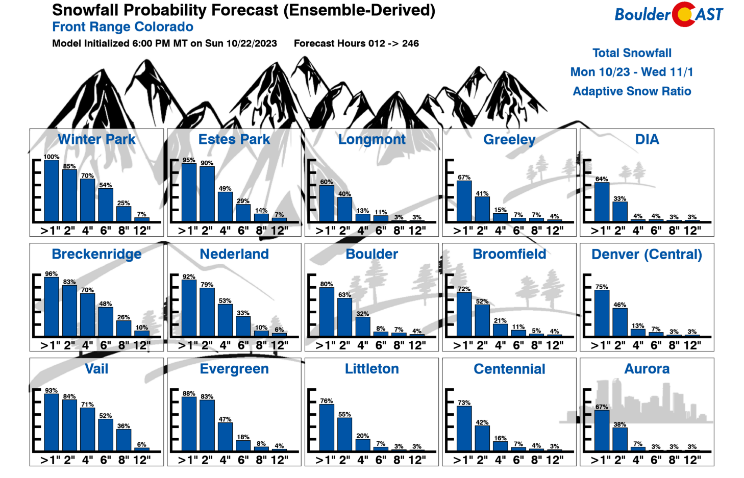
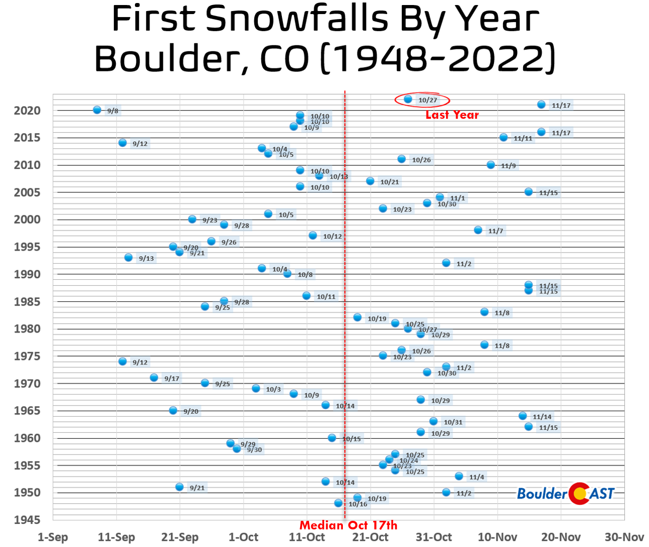
As you are probably aware, our first accumulating snowfall of the season is already past due — Boulder’s historical median date for that is October 17th which has come and gone already. However, last year’s first snowfall was on October 27th. If things pan out with the Arctic blast during the upcoming weekend, we should be notching our first snow around October 29th this year, but let’s not count those chickens before they hatch!
Another, perhaps more certain, aspect of the upcoming weekend is the cold air itself. Some locations across the Denver Metro area still haven’t seen a hard freeze yet, but that discrepancy will resolve itself this weekend as the entire area will drop into the teens or lower 20s for at least one overnight period, if not several in a row. Heck… high temperatures come Sunday and Monday could very well land below freezing, too! This cold weather will continue into early next week before things begin to moderate back towards normal for the first days of November…

Be sure to sign up for our email list as we’ll certainly be providing additional updates later this week as the Arctic airmass and first snowfall (chance) of the season approach! We definitely have some catch-up to do if our recent El Niño autumn outlook is to verify…
Get BoulderCAST updates delivered to your inbox:
Forecast Specifics:
Monday: Mostly sunny and unseasonably warm. High temperatures soar into the lower 80s on the Plains with upper 60s in the Foothills.
Tuesday: Cooler following a weak frontal push. Morning sun trends towards overcast skies by afternoon. High temperatures reach the lower 70s on the Plains with lower 60s in the Foothills.
Wednesday: The last really warm day under mostly sunny skies. High temperatures in the middle to upper 70s on the Plains with middle 60s in the Foothills.
Thursday: Cooler with temperatures somewhat uncertain as a stalled frontal boundary will be across the Front Range area. Highs north of the front in the 50s, but 70s south of the front. There will also be a slight chance of a late-day shower or thunderstorm, mainly east and southeast of Denver though.
Friday: Much cooler and overcast with a slight chance of low clouds, drizzle and/or rain showers. Highs top out in the middle 40s to lower 50s on the Plains with lower 40s in the Foothills.
Weekend: The Arctic cold front will arrive over the weekend, likely sometime Saturday. Sub-freezing temperatures will move in behind the front with highs near or below freezing for a few days and overnight lows around 20°. There will also be a chance of light snow accompanying this front for everyone. Plan now for a shift towards winter-like conditions!
DISCLAIMER: This weekly outlook forecast is created Monday morning and covers the entire upcoming week. Accuracy will decrease as the week progresses as this post is NOT updated. To receive daily updated forecasts from our team, among many other perks, subscribe to BoulderCAST Premium.
Go Premium, get all the perks.
Daily Forecast Updates
Get our daily forecast discussion every morning delivered to your inbox.
All Our Model Data
Access to all our Colorado-centric high-resolution weather model graphics. Seriously — every one!
Ski & Hiking Forecasts
6-day forecasts for all the Colorado ski resorts, plus more than 120 hiking trails, including every 14er.
Smoke Forecasts
Wildfire smoke concentration predictions up to 72 hours into the future.
Exclusive Content
Weekend outlooks every Thursday, bonus storm updates, historical data and much more!
No Advertisements
Enjoy ad-free viewing on the entire site.
Enjoy our content? Give it a share!


You must be logged in to post a comment.