After a largely quiet and long Thanksgiving weekend, things get going quickly this week with widespread accumulating snow developing across the Front Range late Monday night into Tuesday alongside much colder conditions. Afterwards, the rest of the week will see moderating temperatures and generally dry/quiet weather, but we are tracking more snow in the Mountains on Friday. Read on for all the details.
This week’s highlights include:
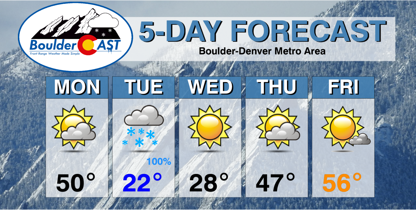
- Quiet and seasonal on Monday with highs around 50 degrees
- A cold front and jet-forcing enter the area Monday night into Tuesday morning bringing widespread accumulating snow to the area.
- The timing and possible heavy intensity of the snow will mean a tricky Tuesday morning commute
- Much colder weather Tuesday and Wednesday with highs only in the 20s
- Moderate temperatures expected late week back into the 40s and 50s with Mountains snow returning late-week
DISCLAIMER: This weekly outlook forecast is created Monday morning and covers the entire upcoming week. Accuracy will decrease as the week progresses as this post is NOT updated. To receive daily updated forecasts from our team, among many other perks, subscribe to BoulderCAST Premium.

Widespread accumulating snow Monday night into Tuesday
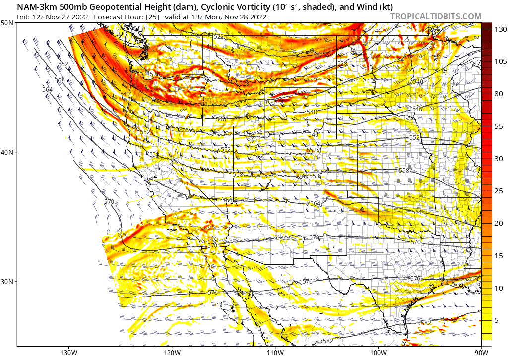
The active wavetrain across the northern Rockies continues to start the week. A quick-hitting trough will race across the Centennial State Monday night through Tuesday bringing a period of favorable forcing for widespread snowfall across the entire Front Range.
Before this though, Monday will be fairly quiet and seasonal across the lower elevations with highs right around 50 degrees. Expect intermittent wave clouds to fill the skies through your Monday.
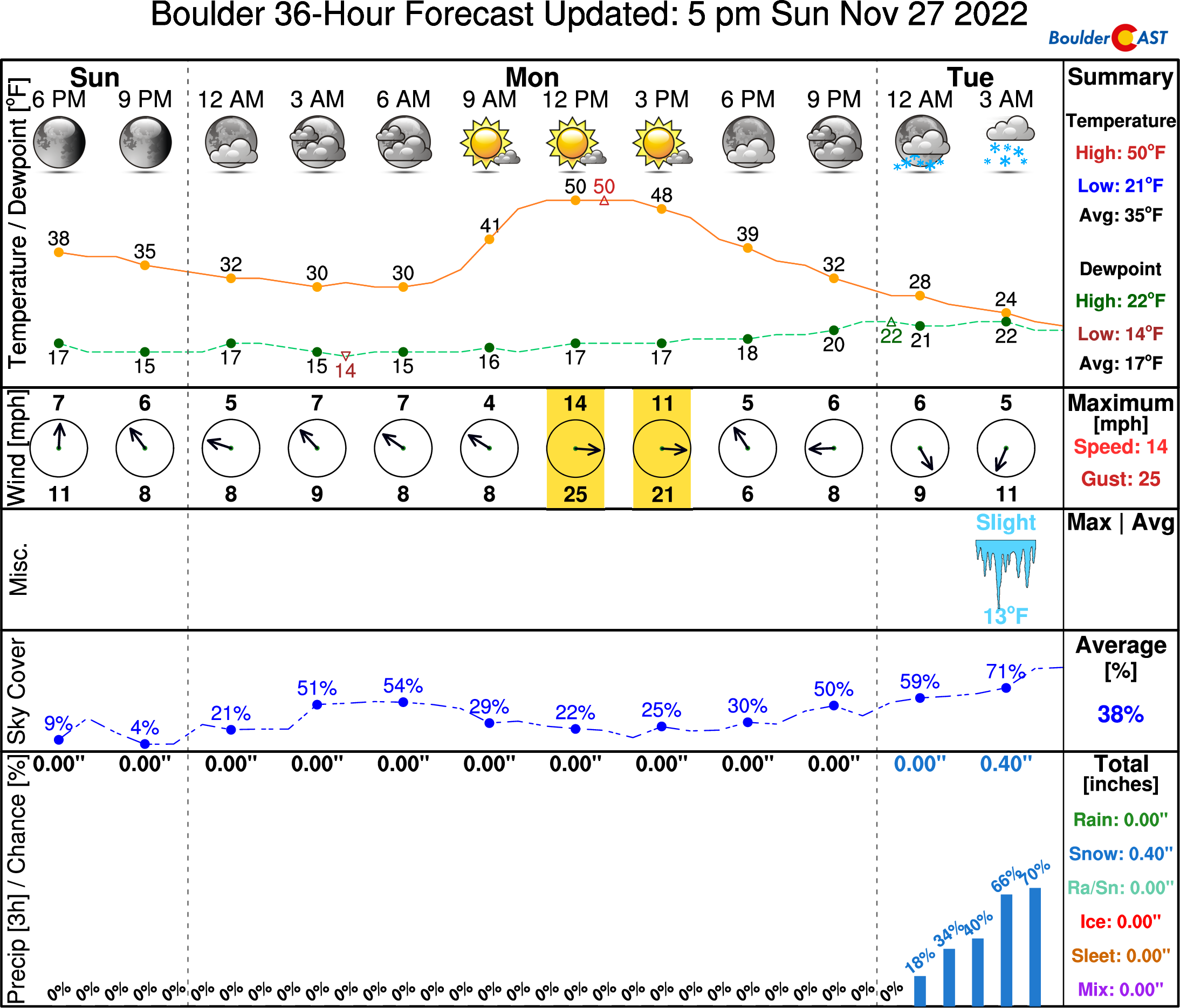
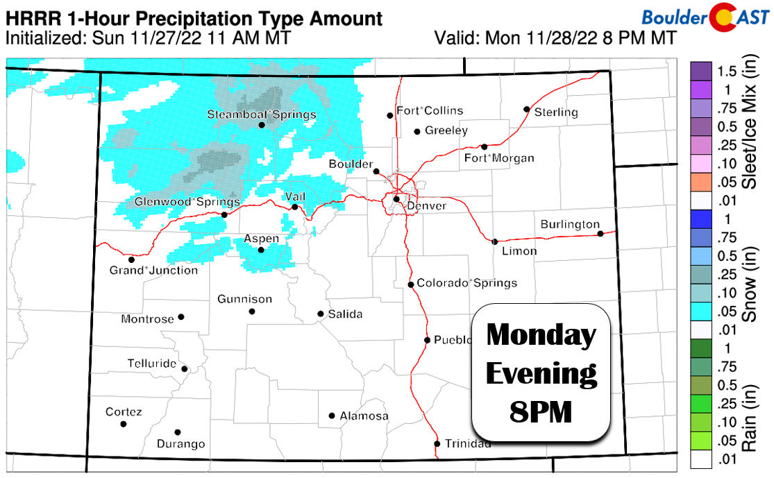
Snow will spread into the Mountains by afternoon and especially in the evening with travel deteriorating across the passes quickly by Monday evening.
Across the lower elevations, things will start to unfold after sunset Monday evening with the arrival of a shallow cold front. This will commence the upslope and usher in those wonderful “bovine” smells to the Denver Metro area. The air will be too dry for precipitation early on, but things will slowly moisten up through the evening before the main event begins after midnight.
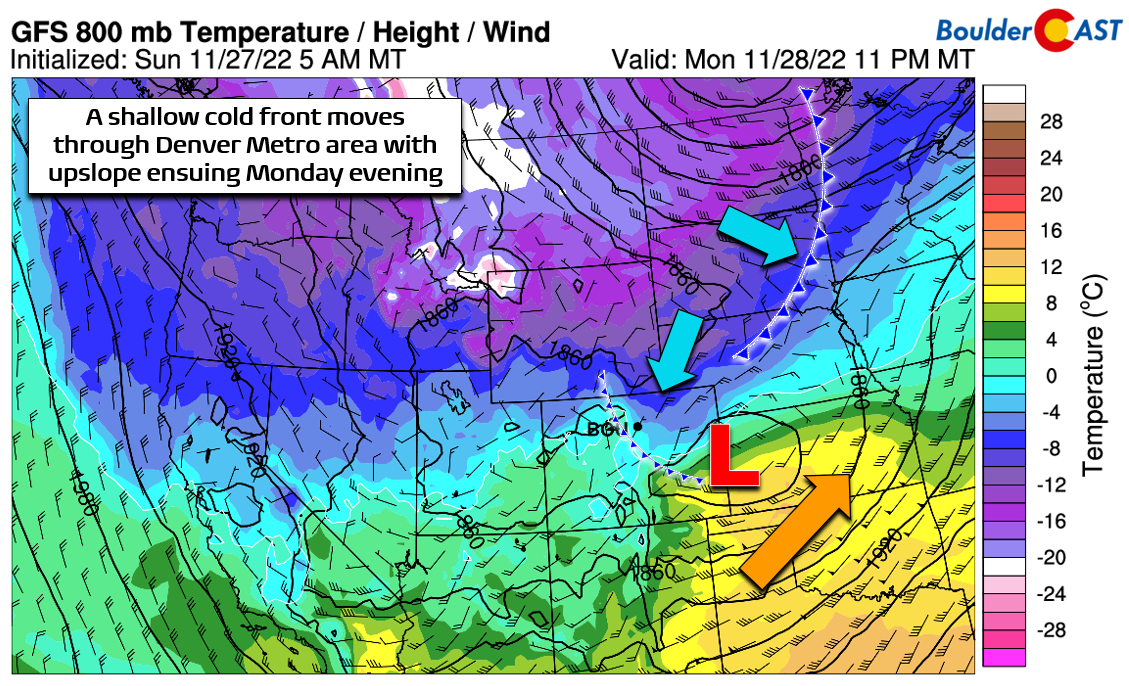
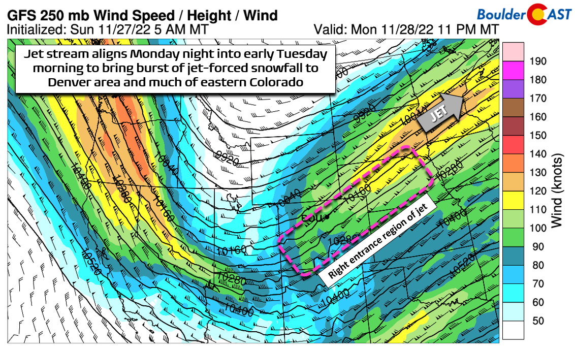
The main cold front AND the right-entrance region of the jet stream will reach the Front Range just after midnight Monday night. This is a great setup for us — one which will spawn a broad band of moderate to heavy snow dropping southeast across most of northern Colorado!
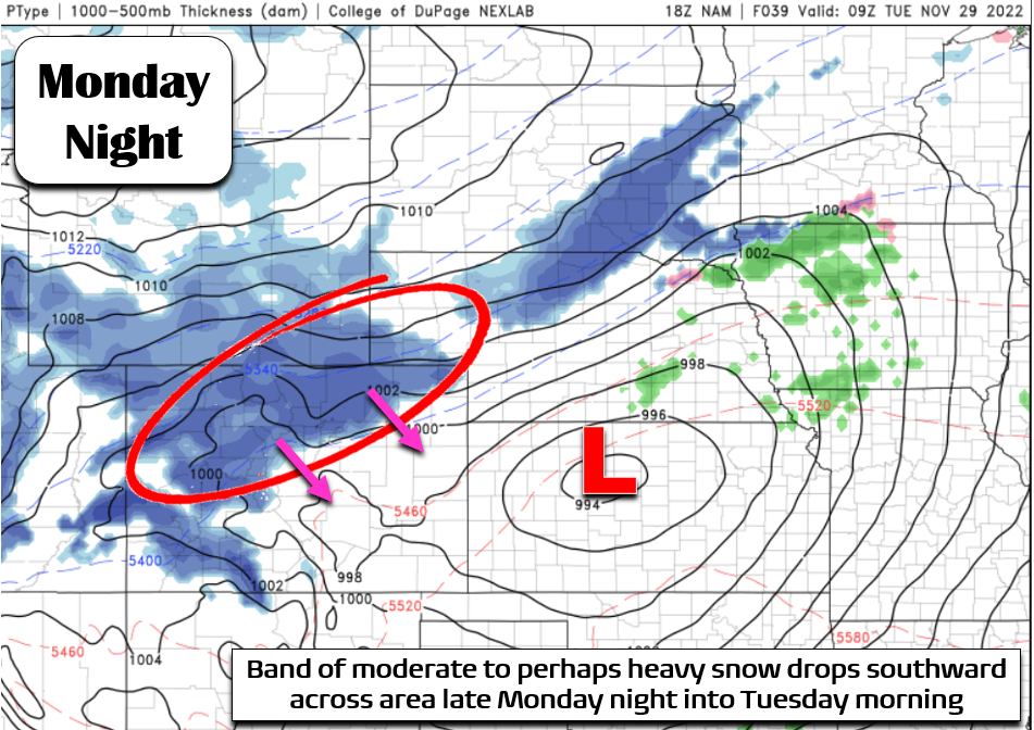
Here’s how the jet- and frontally-forced snow band looks in the NAM model at 2AM Tuesday:
Here’s how it looks in the GFS model at the same forecast time:
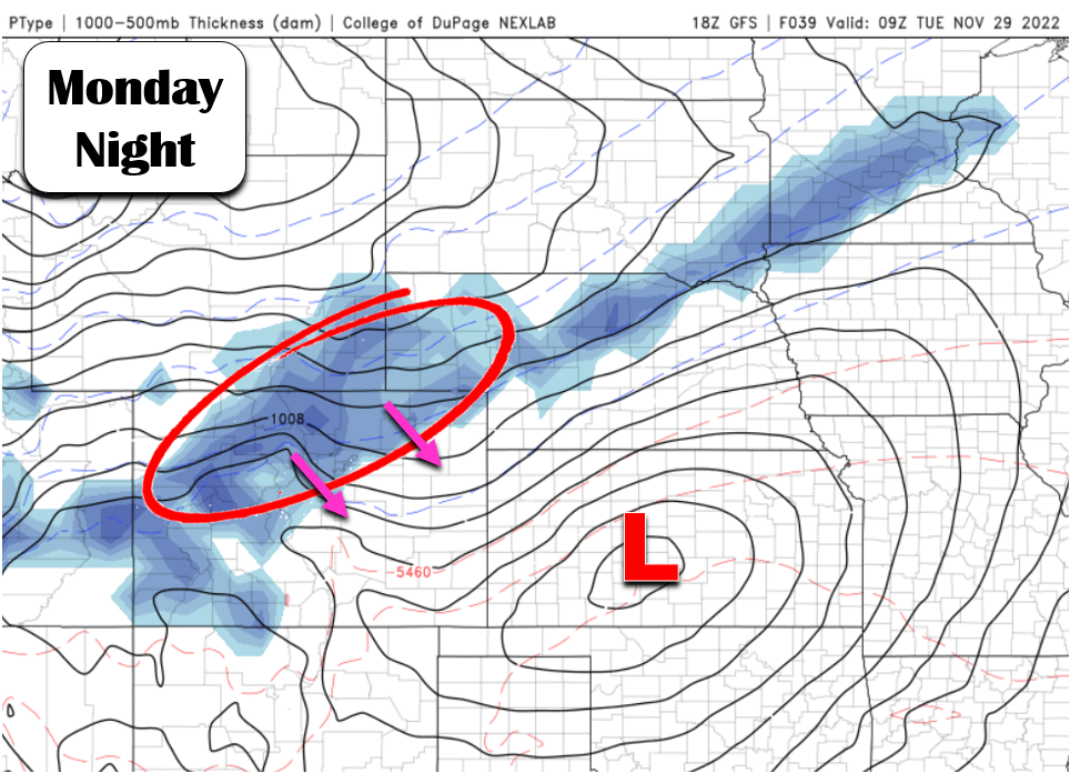
If things pan out as we believe they will, this broad band should produce snowfall rates of 1″+ per hour for several hours early Tuesday, setting the stage for a slick and snowy morning commute just about everywhere. If you can avoid travelling early Tuesday, we highly recommend it! The worst of the snow should wrap up by late-morning Tuesday, with only light snow lingering into the afternoon west and south of Denver.
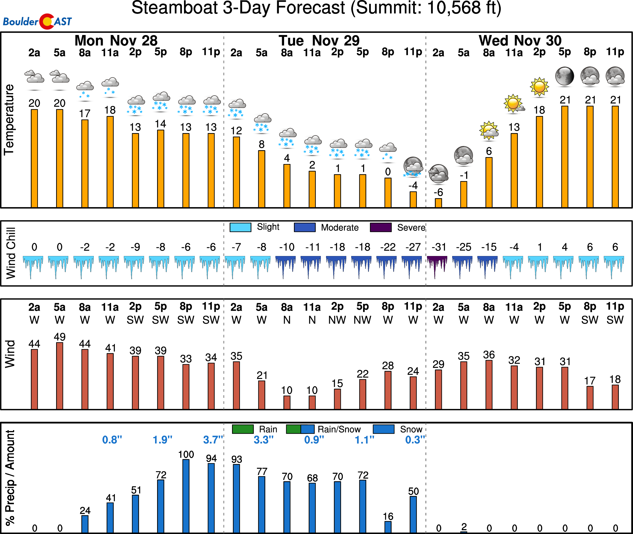
Snowfall amounts will be sizable in the Mountains where 24 hours of favorable orographics will dump more than a foot of snow in the northern ranges (Park and Gore), including around Steamboat and Winter Park.
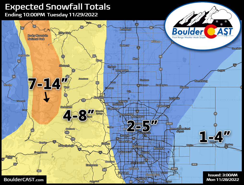
East of the Mountains, snowfall amounts will largely depend on how hard that early morning snow band hits and how slowly it rakes across the area. If it moves through on the speedy end of model solutions, most areas would see just 1-3″. If it moves through on the slower end, we could be talking widespread 4-8″ totals. Our forecast calls for something in between, with generally 2-5″ for most of the Metro area and slightly higher totals in Boulder and the Foothills where low-level upslope will help things along most.
Our snowfall forecast map for the event is shown below. This covers all snow falling through Tuesday evening.
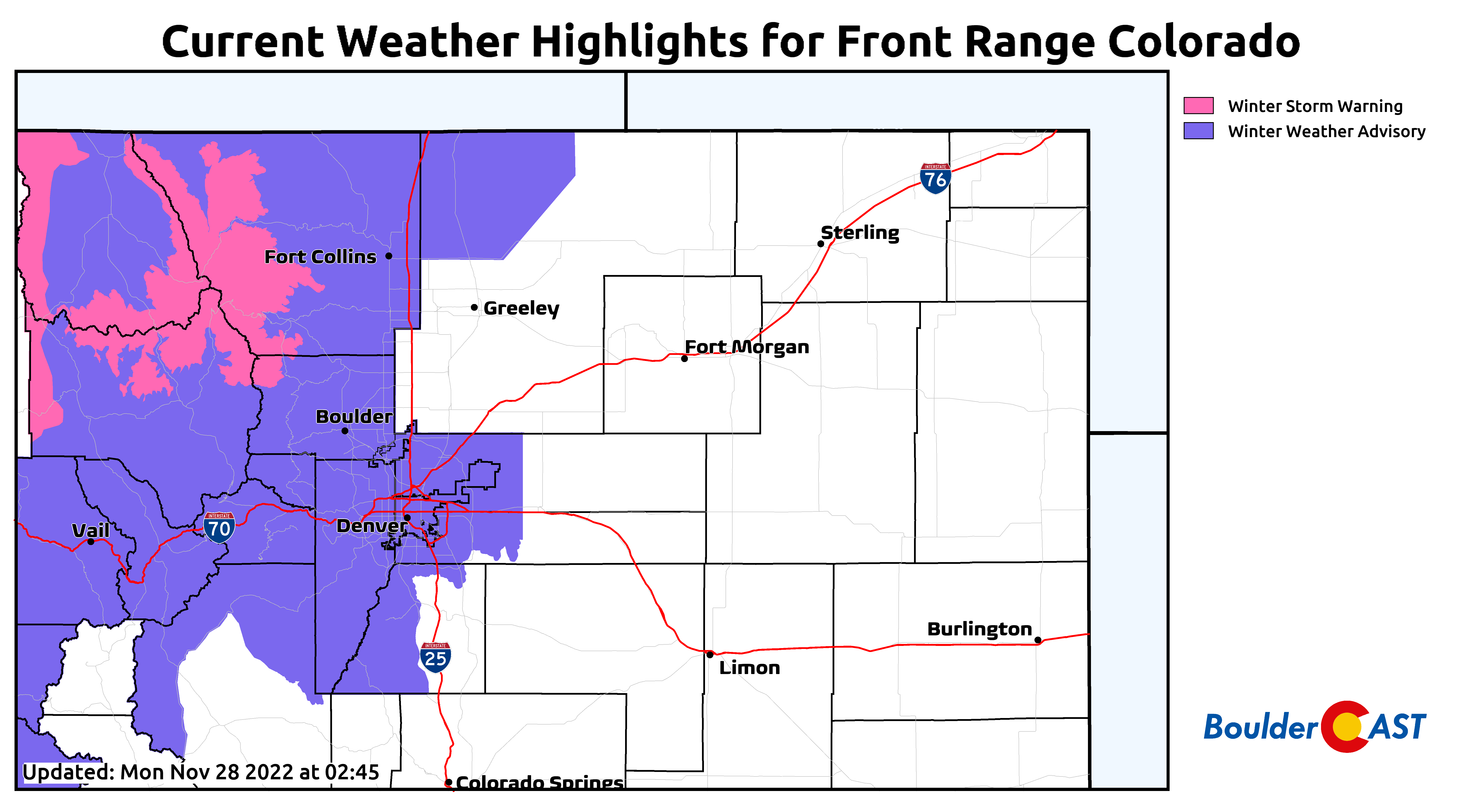
Winter Storm Warnings are posted above 10,000 feet from Rocky Mountain National Park northward. Elsewhere, Winter Weather Advisories are in effect for the Foothills and lower elevations to draw attention to the messy travel conditions, especially Tuesday morning.
Here’s the summary of what to look for over the next 48 hours in Front Range Colorado:
- Snow spreads into the Mountains Monday afternoon and evening with deteriorating travel
- Light snow/flurries may develop late Monday evening, but the main event is expected to commence after midnight Monday night into Tuesday morning. Snow could be heavy at times leading up to and during the morning commute Tuesday. Travel with care!
- The bulk of the snow should be done by late-morning Tuesday with just light snow and flurries lingering into afternoon.
- Snowfall accumulations of more than a foot in the northern Mountains, 4-8″ in the Foothills and Boulder and 1-5″ in Denver.
- Highs on Tuesday will only be in the lower 20s
A cold Wednesday
The winter storm system exits east of the area on Wednesday with northwest flow backing to westerly during the day. The morning will be bitter cold with single digit temperatures expected on the lowlands with below zero temperatures in the Foothills and Mountains. The cold airmass remains entrenched with little in the way of warming — highs will only top out around 30 degrees.
Seasonal but potentially windy late week
From late Wednesday through the end of the week, flow will turn from westerly to eventually southwesterly but remain strong. First and foremost, this will help to oust that frigid airmass away from Colorado to the east with downslope flow taking over. High temperatures will push back closer to seasonal values in the middle 40s to upper 50s by Thursday and Friday.
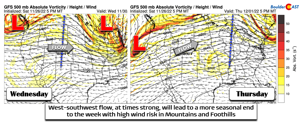
We will need to watch for high wind potential during this time, especially in the Mountains and Foothills. It’s unclear if this will materialize just yet, but high winds do look possible during the late-week timeframe.
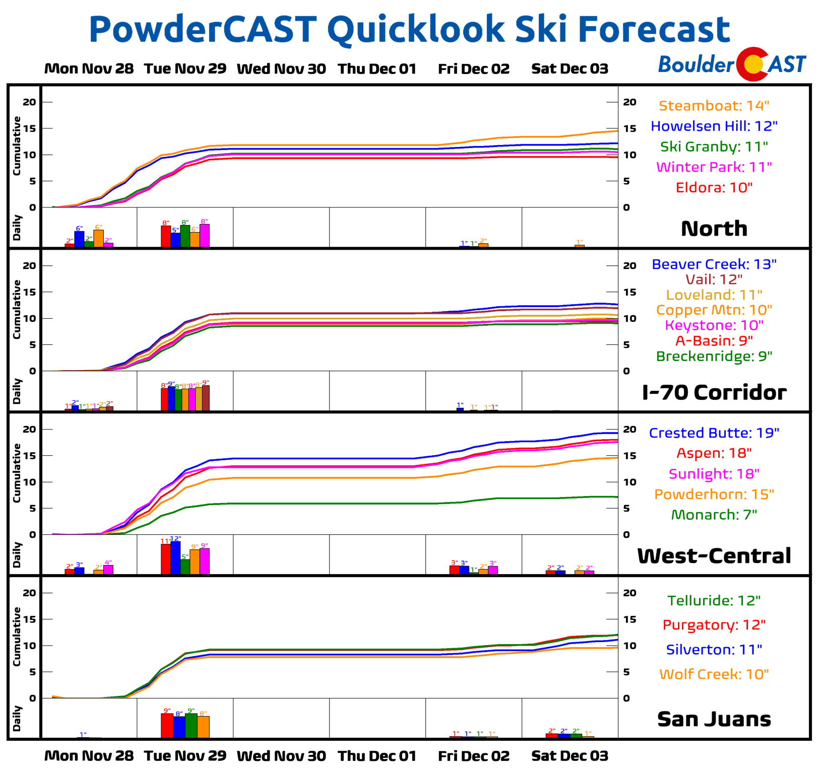
Eventually, yet another weather system will enter the picture from the Pacific Northwest. Long-range model guidance is not in great agreement with this one, but for the most part we expect it to bring more wintry impacts to the High Country but with a large part of the energy and moisture coming together north of Colorado during the upcoming weekend. The ski resorts should see another several inches of powder Friday into Saturday with little to no chance of seeing any snow east of the Mountains.
Forecast Specifics:
Monday: Pleasant with wave clouds throughout the day. Highs near 50 degrees on the Plains and in the upper 30s in the Foothills.
Tuesday: Overcast with widespread accumulating snowfall, heavy at times in the morning making for a slick AM commute. Snow will decrease in coverage and intensity through the day, wrapping up in most places by afternoon. Highs only in the lower 20s on the Plains and in the teens in the Foothills.
Wednesday: Staying cold but sunny with highs around 30 degrees on the Plains and in the lower 20s in the Foothills.
Thursday: Partly cloudy and cool with highs in the 40s on the Plains and in the 30s in the Foothills. West winds will be gusty in favored areas east of the Divide.
Friday: Mostly sunny and pleasant, but possibly still breezy to windy in spots. Highs reach the 50s on the Plains with 40s in the Foothills.
High Country: Snow will spread into the Mountains Monday afternoon into the overnight, ending Tuesday morning. The northern Mountains will do best from this system with more than a foot of snow possible in these areas. A second round of snow arrives Friday into Saturday with several inches possible statewide again. Winds will be gusty throughout the entire week.
Help support our team of Front Range weather bloggers by joining BoulderCAST Premium. We talk Boulder and Denver weather every single day. Sign up now to get access to our daily forecast discussions each morning, complete six-day skiing and hiking forecasts powered by machine learning, first-class access to all our Colorado-centric high-resolution weather graphics, bonus storm updates and much more! Or not, we just appreciate your readership!
Spread the word, share the BoulderCAST forecast!


You must be logged in to post a comment.