
March is supposed to bring hints of spring, not the kind of heat that rewrites the record books and eats away snowpack like it’s June. Yet here we are again, recapping another weekend of astonishing warmth, more broken records, and a dire Westwide snowpack situation that has become genuinely alarming. We walk through just how extreme the heatwave has been, why Colorado’s water outlook is now in uncharted territory, and what the coming early April pattern shift might (or might not) do to slow the damage that’s already been done. Let’s dig in.
This week’s highlights include:
- 🔥 Heatwave still historic: Boulder hit 80° and 82° over the weekend, breaking two more records and marking the 10th record high of this 12‑day heatwave.
- 📈 Extreme temperature swing: Saturday featured a 50° diurnal jump and was only the third time ever Boulder has gone from below freezing to the 80s in a single day.
- 🏔️ Snowpack collapse now dire: Colorado’s statewide snowpack has plunged to 22% of normal, with most remaining snow only above 11,000 ft on favorable aspects.
- 🚨 Hydrologic emergency: Current Colorado snowpack is 60% below the previous all‑time late‑March minimum, likely the lowest in more than a century threatening spring runoff, water supply, and early‑summer wildfire risk.
- 🔥 Fire danger Monday: Downslope warmth, RH <15%, and gusts to 20–30 MPH prompted a Red Flag Warning for Boulder, Fort Collins, and the Foothills as temperatures head toward record territory.
- 🌡️ Cooler midweek: A Tuesday cold front drops highs ~20 to 25° with scattered showers Wednesday and 3–12 inches of much‑needed Mountain snow.
- 🌬️ Thursday warm‑up: Brief ridging brings 70s and possibly another fire‑weather day depending on midweek moisture.
- ❄️ Late‑week storm uncertain: Ensembles split between a wetter, slower trough (rain/snow possible) and a drier, northern track. Confidence low, but any precipitation would be great.
DISCLAIMER: This weekly outlook forecast is created Monday morning and covers the entire upcoming week. Accuracy will decrease as the week progresses as this post is NOT updated. To receive daily updated forecasts from our team, among many other perks, subscribe to BoulderCAST Premium.

Go Premium, get all the perks.
Daily Forecast Updates
Get our daily forecast discussion every morning delivered to your inbox.
All Our Model Data
Access to all our Colorado-centric high-resolution weather model graphics. Seriously — every one!
Ski & Hiking Forecasts
6-day forecasts for all the Colorado ski resorts, plus more than 120 hiking trails, including every 14er.
Smoke Forecasts
Wildfire smoke concentration predictions up to 72 hours into the future.
Exclusive Content
Weekend outlooks every Thursday, bonus storm updates, historical data and much more!
No Advertisements
Enjoy ad-free viewing on the entire site.
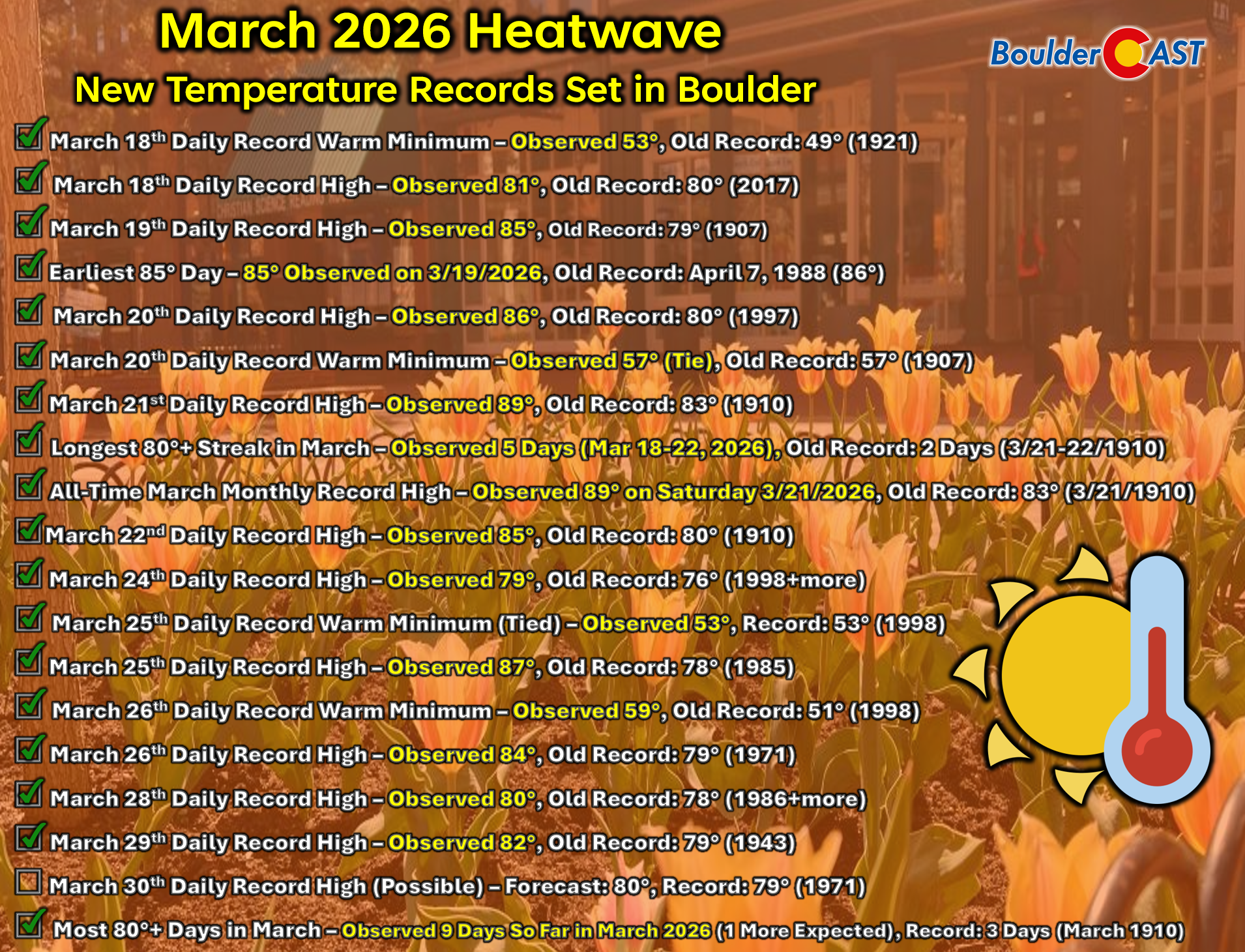
Heatwave update: More records have fallen
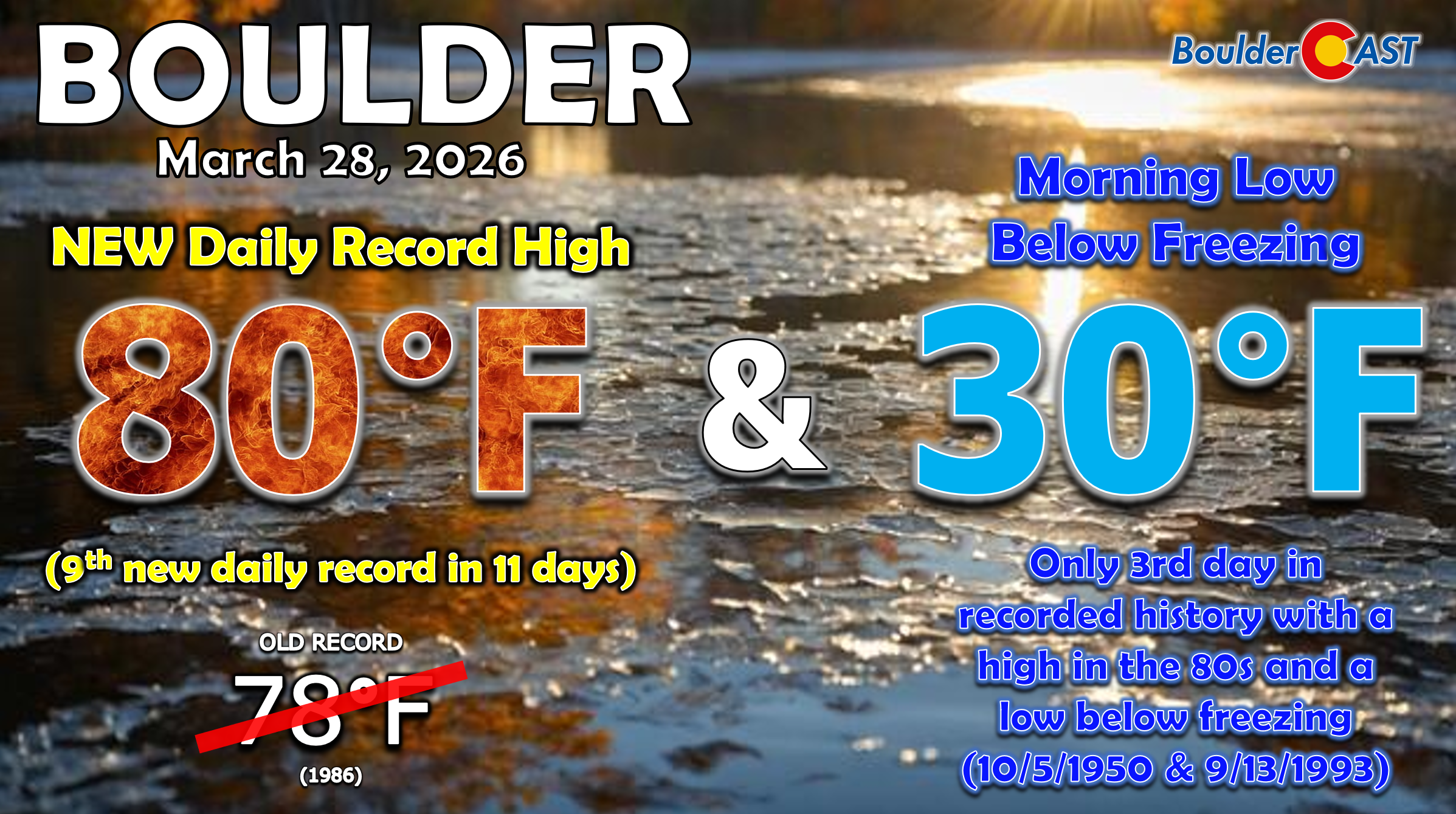
The unprecedented Southwestern heatwave rolled straight through the weekend, delivering yet another round of record‑setting temperatures along the Front Range. Boulder hit 80° on Saturday, breaking the previous March 28th record of 78°. Even more remarkable: Saturday became only the third time in recorded history that Boulder began the day below freezing and still surged into the 80s. The official low was 30°.
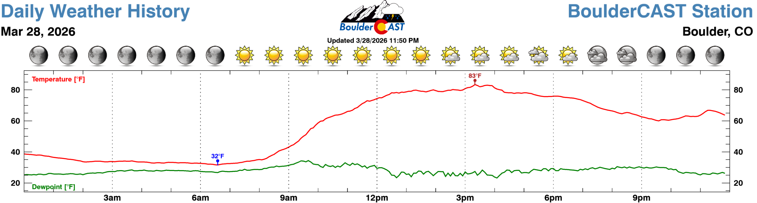
Here’s the temperature curve from our weather station on Saturday, with a staggering 51° temperature swing from morning to afternoon!
Sunday pushed the envelope further. Boulder reached 82°, toppling yet another daily record — the 10th record high to fall during this now 12‑day heatwave.
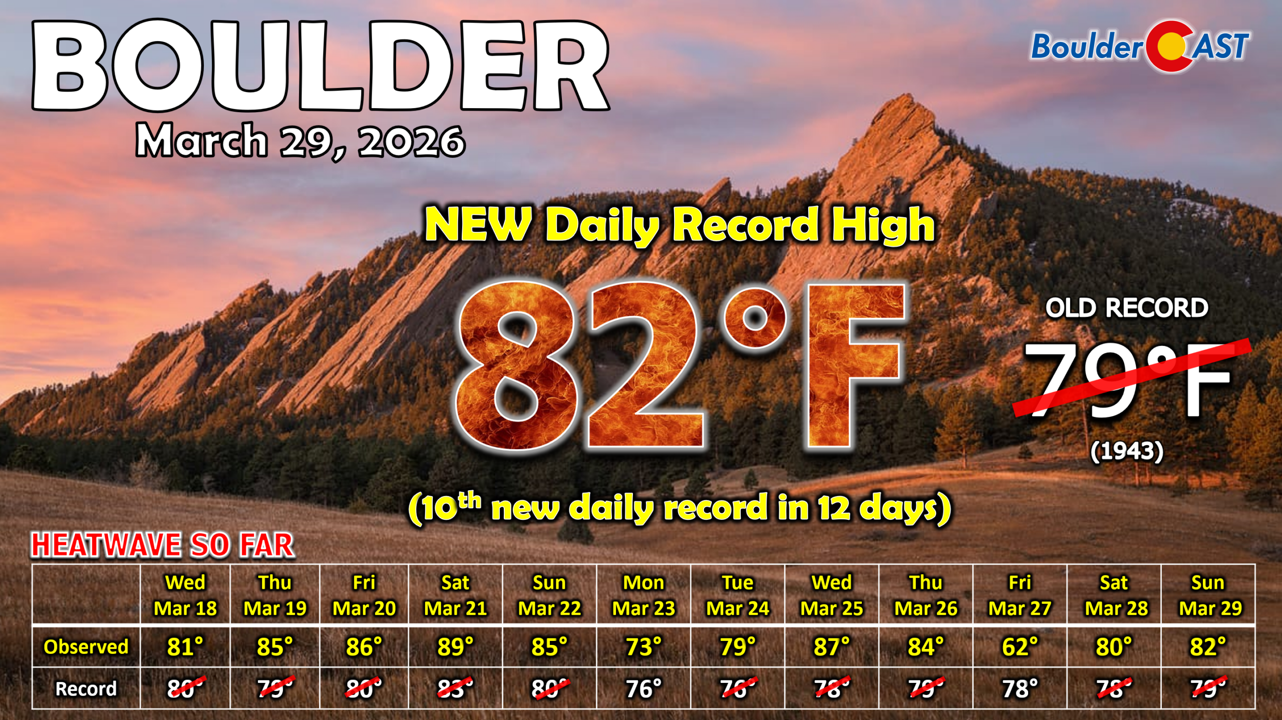
Additional records have fallen across the region as well, too numerous to list individually. The graphic below highlights the scope of this historic warmth.
Western snowpack has collapsed and we’ve entered uncharted territory
As expected — and feared — the Westwide snowpack has been absolutely gutted by two weeks of June‑like temperatures in March. Much of the West entered this heatwave already in trouble after a warm, dry winter and a stubborn northern storm track that repeatedly favored Montana and the Canadian Rockies. Now, after back‑to‑back weeks of unprecedented March heat, very little snow remains anywhere outside of the highest peaks in the Rockies, Sierra, and Cascades.
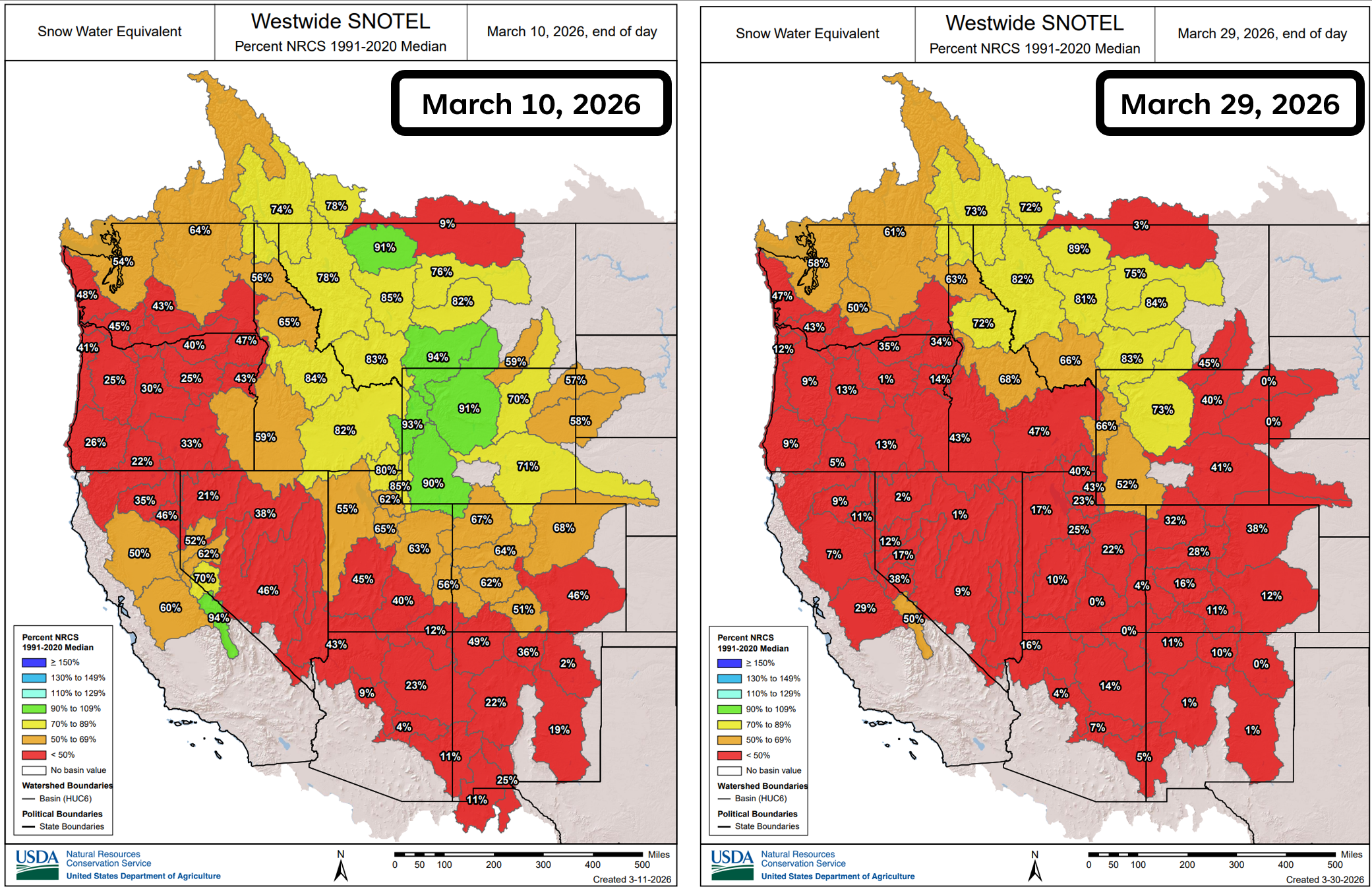
As of Monday morning, Colorado’s statewide snowpack sits at just 22% of normal, with what little remains confined almost exclusively to elevations above 10,000 feet and only on slopes with favorable aspects or shaded by dense tree cover. That is the closest thing we have to “good news” right now — snow at these elevations melts more slowly and will be more resilient in the coming weeks — but it does little to offset the severity of the situation.
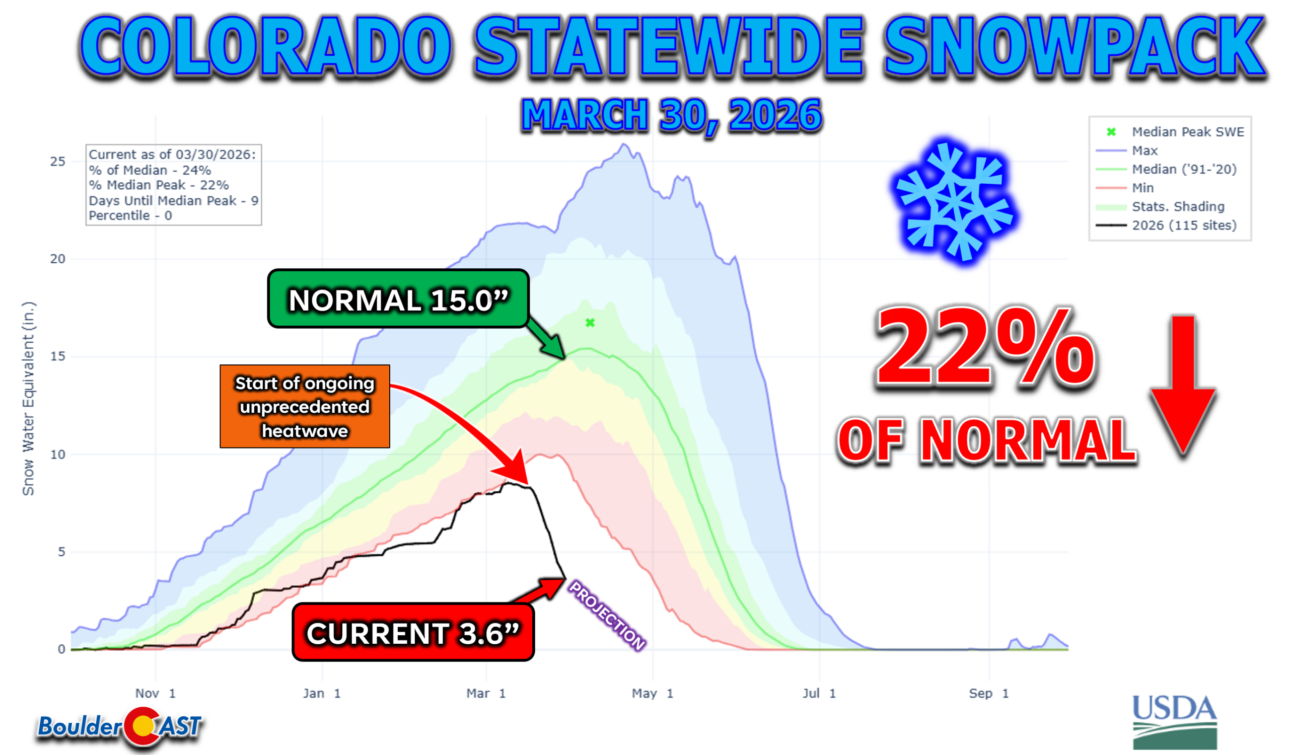
Colorado’s current snowpack is now more than 60% lower than the previous all‑time minimum for late March, a record that goes back to the early 1980s when automated SNOTEL monitoring began. And when you layer in written accounts from early settlers, mining‑era surveyors, and Forest Service observers — who frequently documented deep spring snowpack well into April and May — it becomes entirely plausible that this is the lowest late‑March snowpack in more than a century for our state.
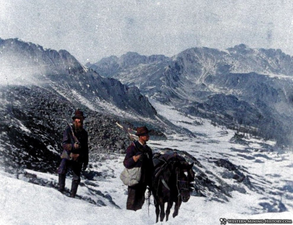
Prospectors enter the Rocky Mountains of Colorado during the Colorado Gold Rush ca. 1858 | WesternMiningHistory.com
Colorado has certainly endured bad winters before. The infamous 1976-77 drought left ski areas hauling snow by truck. The 2001-02 winter triggered catastrophic early runoff and one of the state’s worst wildfire seasons. Even the 2017-18 season, which many remember as painfully snow‑starved, maintained far more mid‑ and high‑elevation coverage than what we’re seeing today. In every one of those years, at least one stabilizing factor remained — colder temperatures, a late‑season storm cycle, or a snowpack that was thin but not obliterated.
This year offers none of those guardrails. Snowfall this low, consistent winter temperatures this mild, and a late‑season heatwave this extreme have simply never overlapped in the modern record. It’s a convergence of these very conditions that has pushed Colorado into territory we’ve likely never had to navigate before, with implications for water supply, soil moisture, and fire danger that will echo well into the summer if not longer.
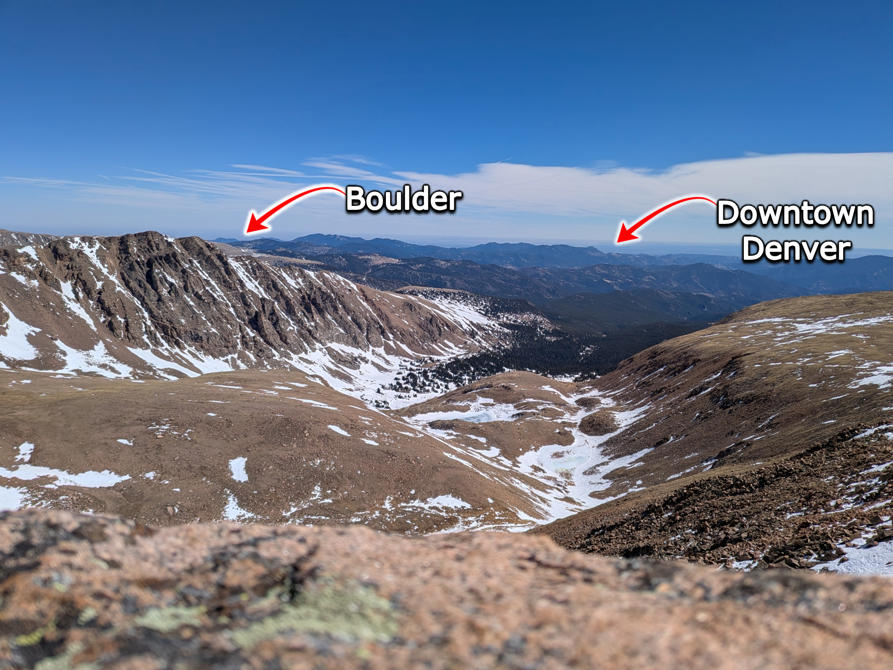
Mills Creek watershed west of Denver/Boulder. March 21 2026. Historically low remaining snowpack. This was taken only a third of the way through the March 2026 Western Heatwave.
Even with a brief early‑April cooldown and some light precipitation on the way this week, the damage done is largely irreversible. The West is entering April with a snowpack profile more typical of late May and that’s not going to change.
This week: Record warmth & fire danger again on Monday
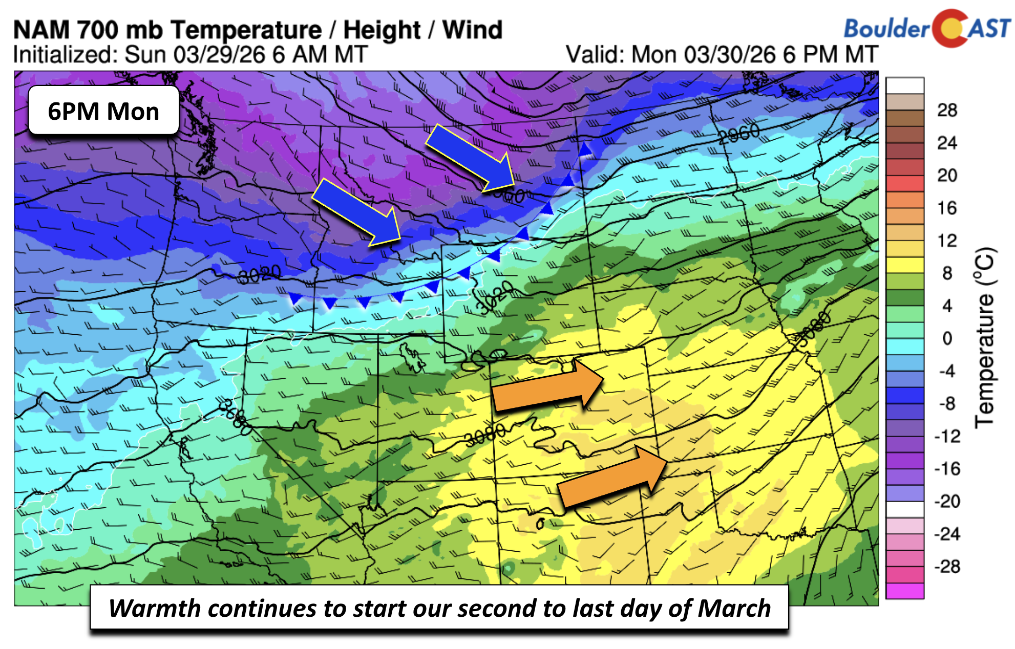
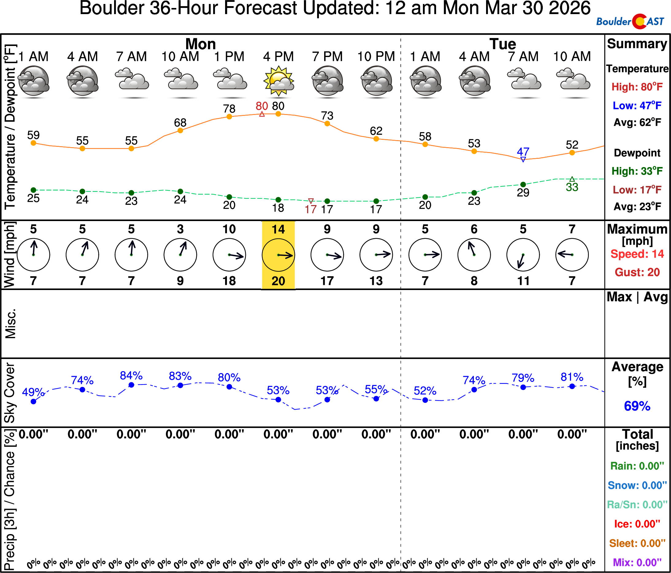
The anomalous weekend warmth will linger one more day into Monday, the second‑to‑last day of March. A warm westerly downslope pattern will persist through the afternoon, supporting another run at near‑80° temperatures. A cold front currently over northwest Wyoming is on track to arrive early Tuesday.
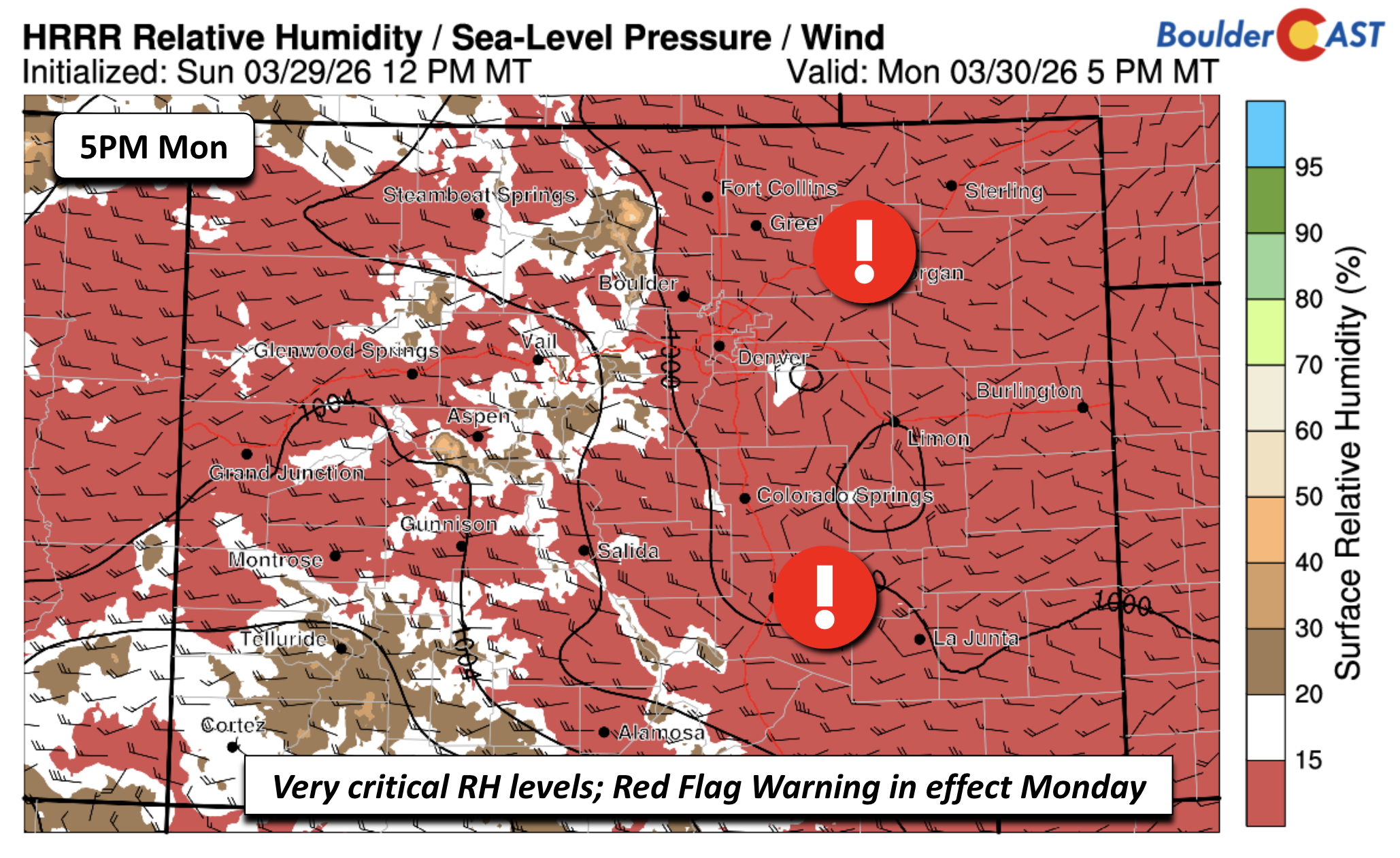
Relative humidity will again plunge well below 15% across the Plains east of the Foothills, creating another day of critical fire‑weather conditions.
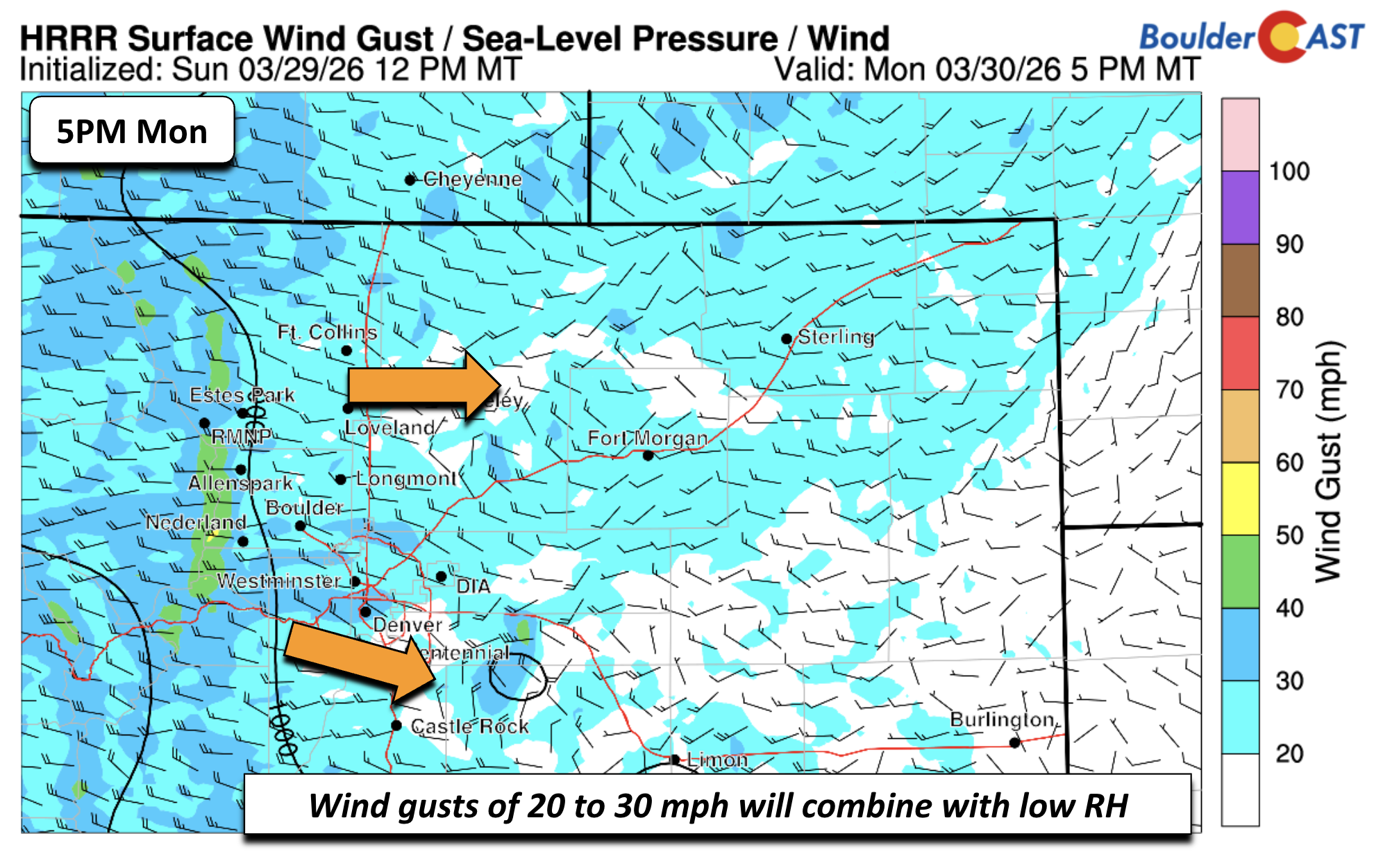
Winds won’t be extreme, but gusts of 20–30 MPH are enough to support rapid fire spread in our drought‑stressed forests and prairie.
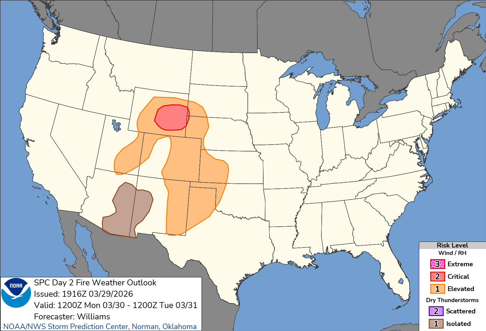
The fire danger threat extends over much of the eastern sections of Colorado, western Kansas, the panhandle of Texas, and eastern New Mexico, with a most critical area being over southeast Wyoming.
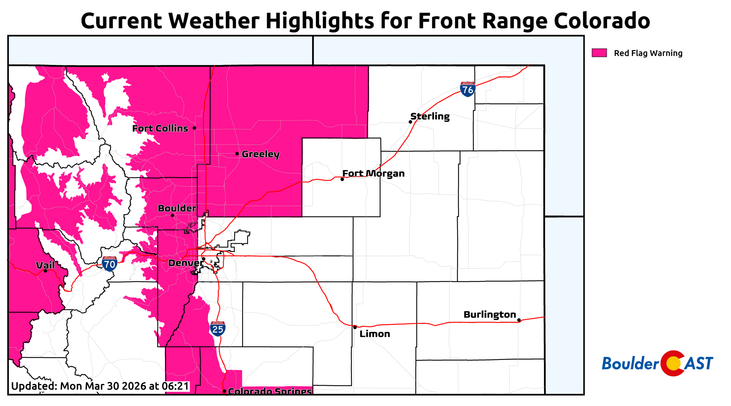
A Red Flag Warning is in effect from 11 AM to 8 PM Monday for portions of the Front Range, including Boulder, Fort Collins, and the Foothills. Fire‑weather discipline is essential today!
Highs will reach around 80° on Monday, putting Boulder’s March 30th record of 79° (set in 2010) well within reach. Denver’s record is 82°.
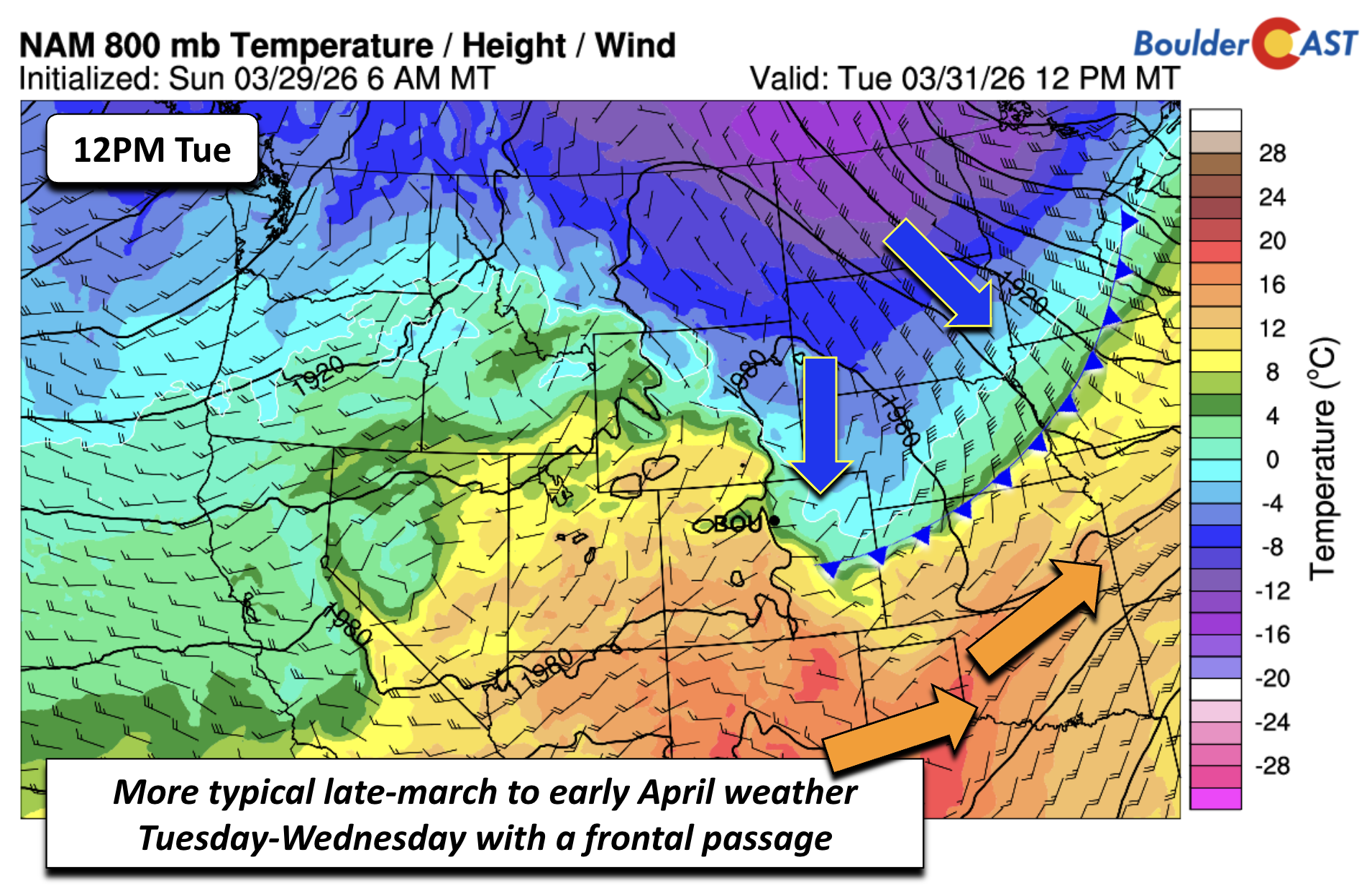
Trending cooler and more unsettled, except Thursday
The Wyoming cold front will sweep through the Metro area early Tuesday. A stray shower is possible Monday night or early Tuesday, but the front will be mostly dry. Highs will drop sharply into the 60s Tuesday and Wednesday — roughly a 20° cooldown compared to Monday.
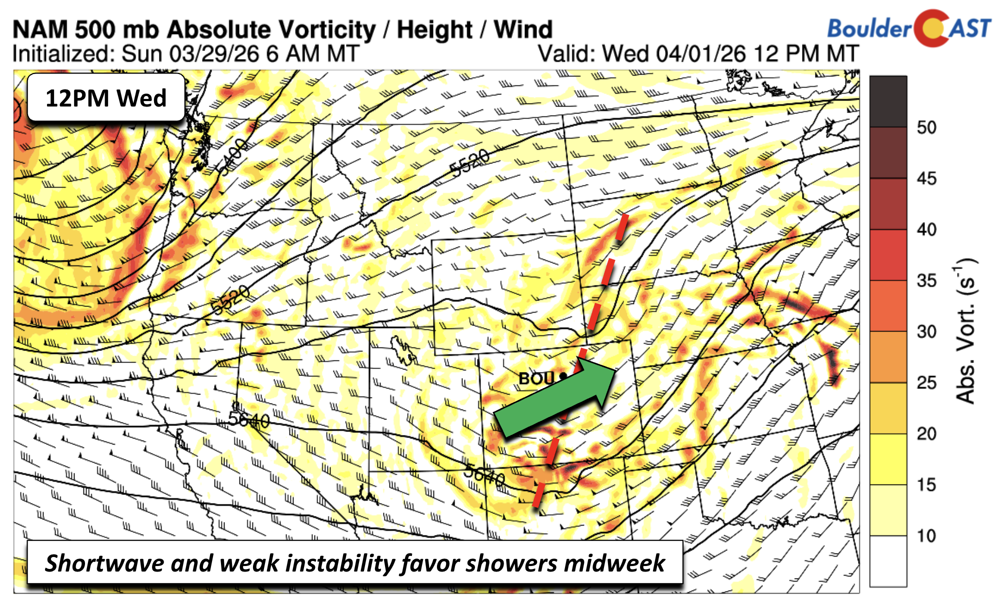
Some morning drizzle is possible Tuesday, with a better chance for unsettled weather Wednesday as a shortwave passes overhead. Moisture and weak instability combined with lingering upslope will produce scattered to numerous showers and perhaps an isolated, non‑severe storm.
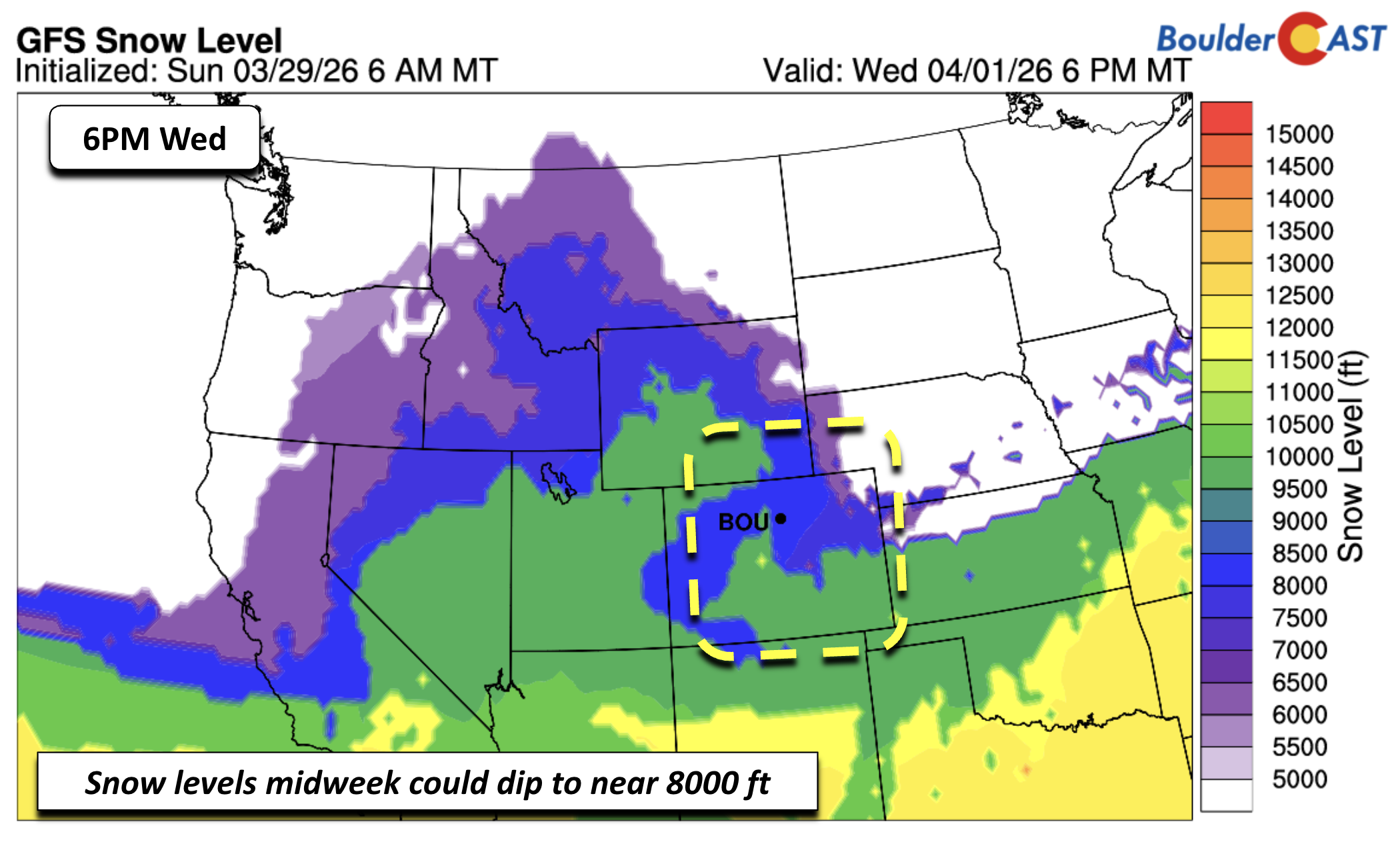
Snow levels will dip to around 8000 feet, allowing for a few flakes in the higher Foothills.
In the High Country, the shortwave will deliver much‑needed snow Tuesday night through Wednesday, with another round coming later in the week. More than a foot is favored for many Colorado peaks and ski resorts by the weekend. This won’t fix the snowpack crisis, that’s for sure, but any accumulation is welcome.
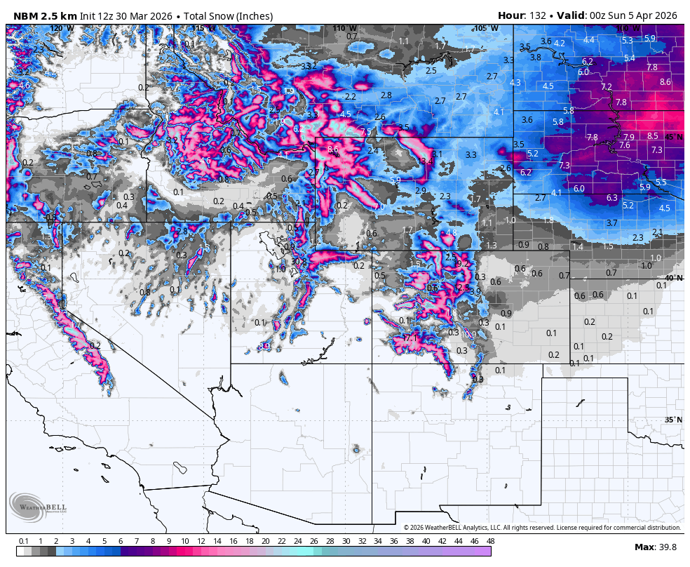
Snowfall potential throughout this week across the Rockies
Late-week outlook: early April snow or another miss?
A brief warmup returns Thursday as ridging builds behind the midweek system. Highs should rebound into the lower 70s, though breezy downslope flow may elevate fire danger again. How much rain falls during the midweek period will influence Thursday’s fire‑weather risk.
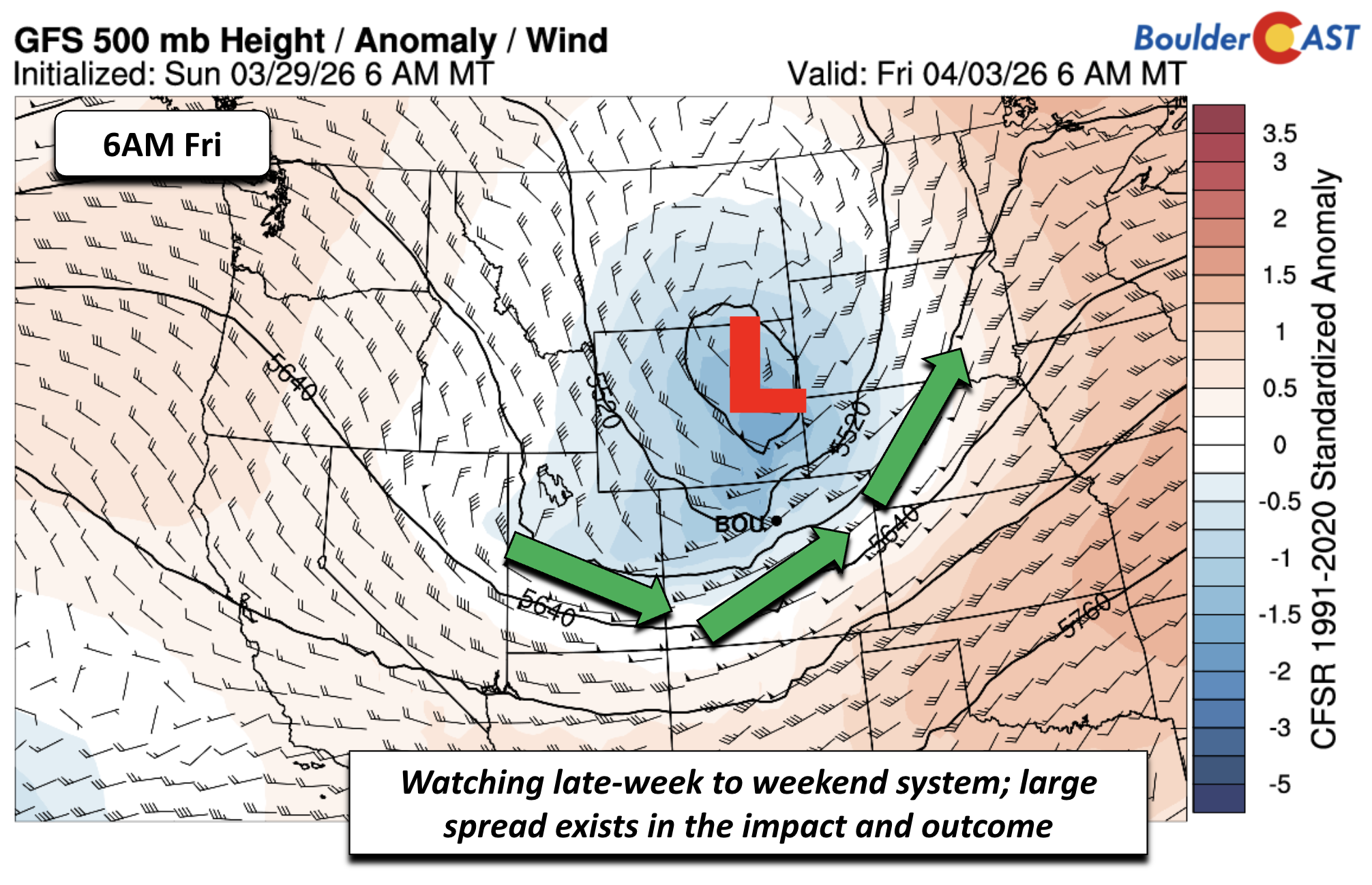
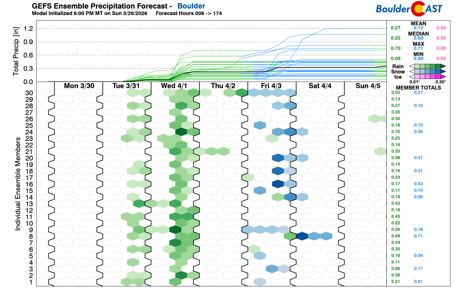
Attention then shifts to a rapidly developing storm system expected to move inland late Thursday or Friday. Model spread is extremely large, and confidence is low. Operational runs — including the GFS — currently favor a warmer, drier scenario with the main trough tracking north into the Dakotas. But ensemble guidance paints a more complex picture.
The GEFS ensemble plume shows midweek precipitation clearly, but Friday–Saturday solutions are split: roughly half the members are dry, while half show rain or snow.
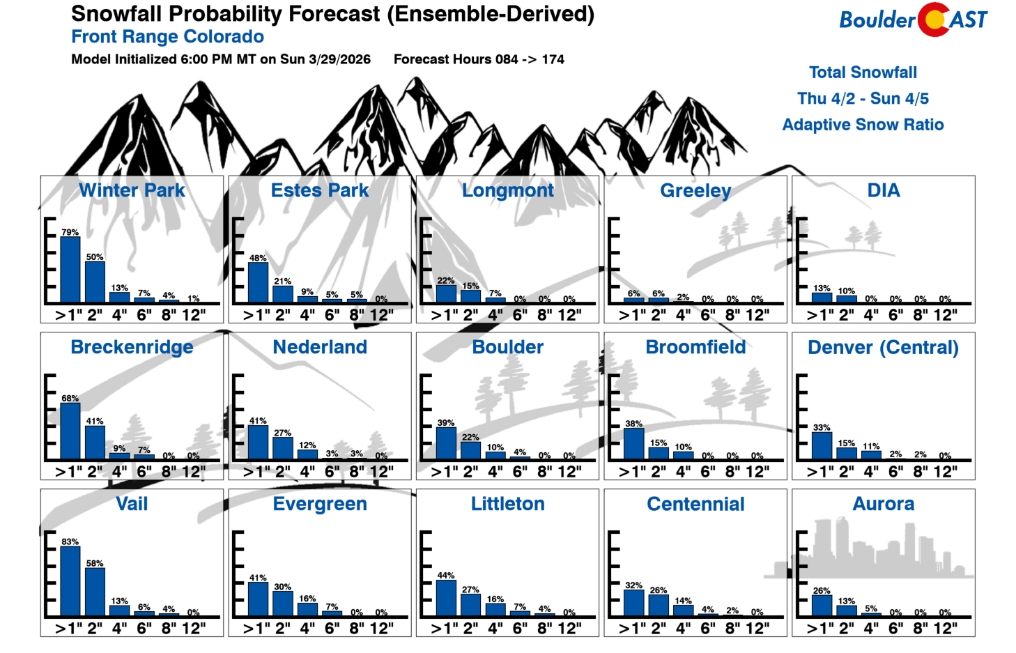
Our snowfall probabilities remain fairly low — only 25–40% chances for at least 1 inch of snow accumulation in Boulder/Denver — with higher odds in the Mountains.
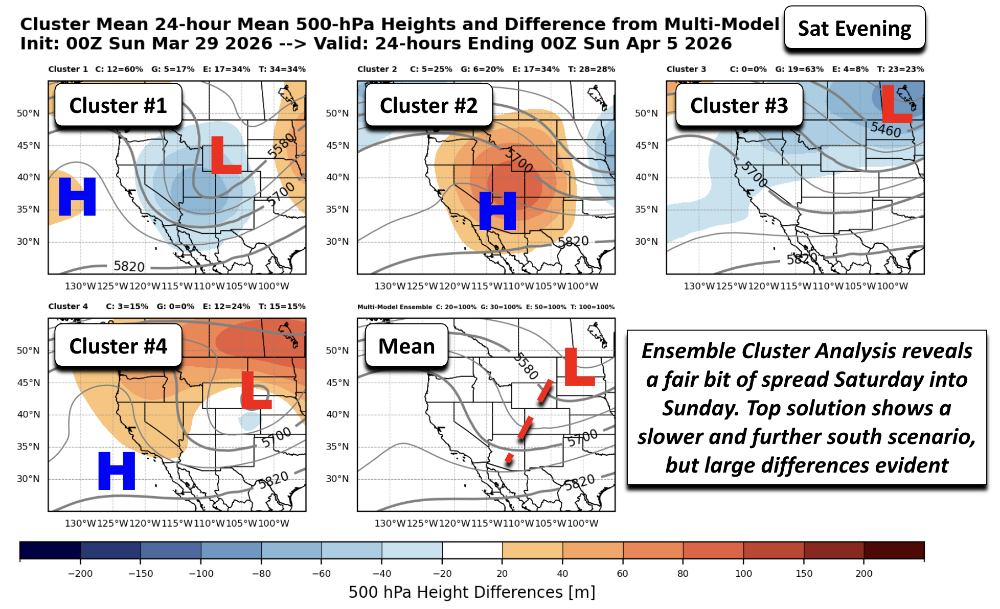
A more in-depth analysis reveals a fair bit of uncertainty between a dry or snow/rain forecast during the late-week and weekend. To illustrate this, let’s review the ensemble cluster solutions, allowing us to see where the most-skilled mid-range forecasts may be trending. Below shows a cluster analysis for a 100-member ensemble of the GEFS, GEPS, and EPS ensemble systems combined. Each cluster solution shows a possible scenario in 500-mb heights for the trough/ridge pattern. The shading indicates how each solution differs (positive = orange; negative = blue) from the mean 500-mb height field. The mean pattern shows a trough extending west of Colorado Friday evening, with its mean center over Wyoming, similar to the GFS. But the first cluster, representing 30% of ensemble solutions, is further west and deeper with the trough. Cluster #2 is also deeper and slower. The #3 and #4 clusters are further north and faster with the trough.
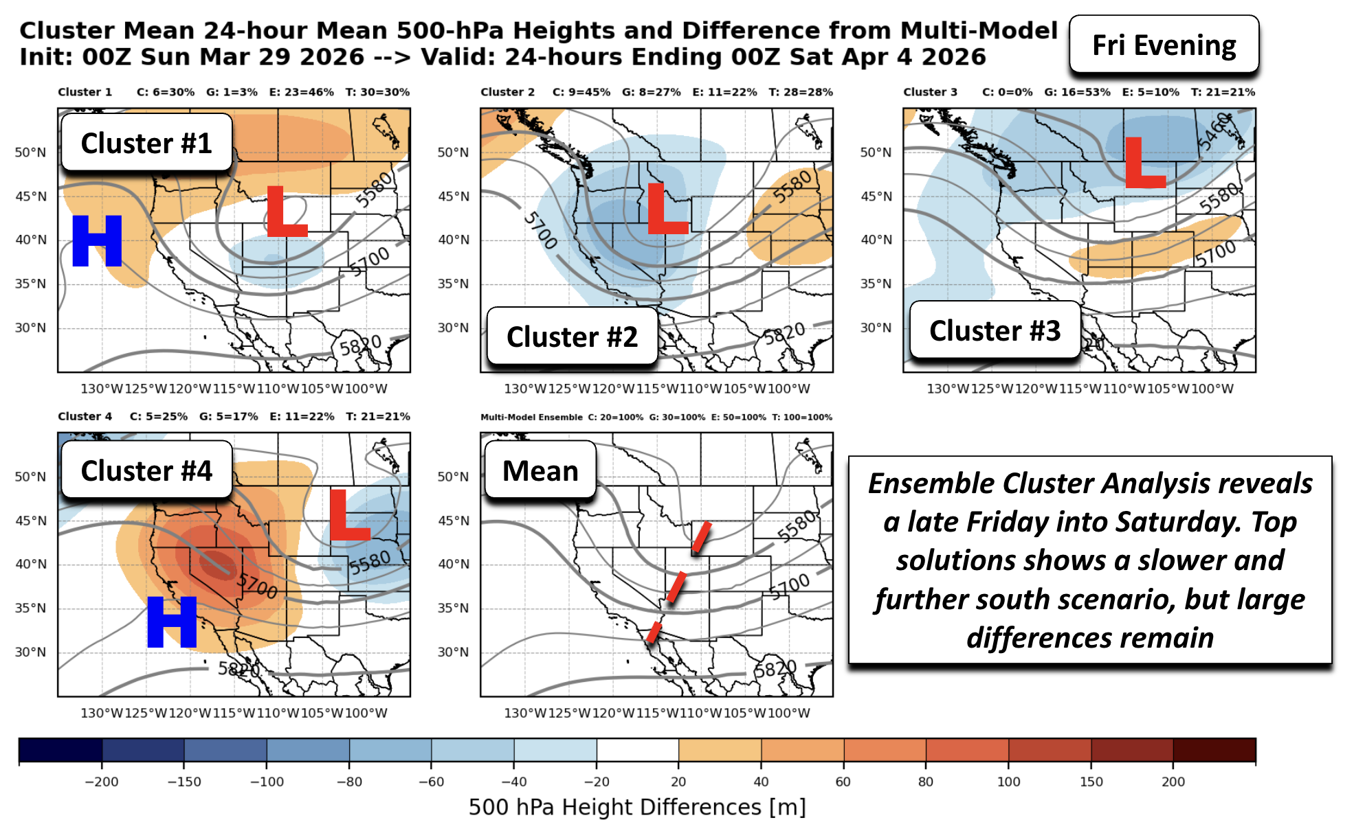
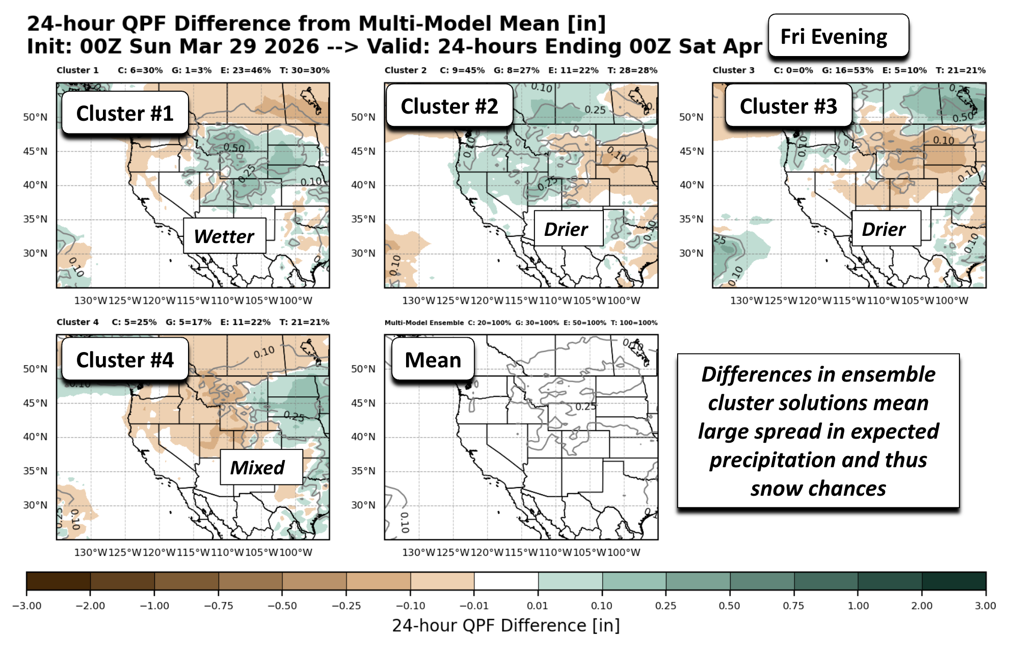
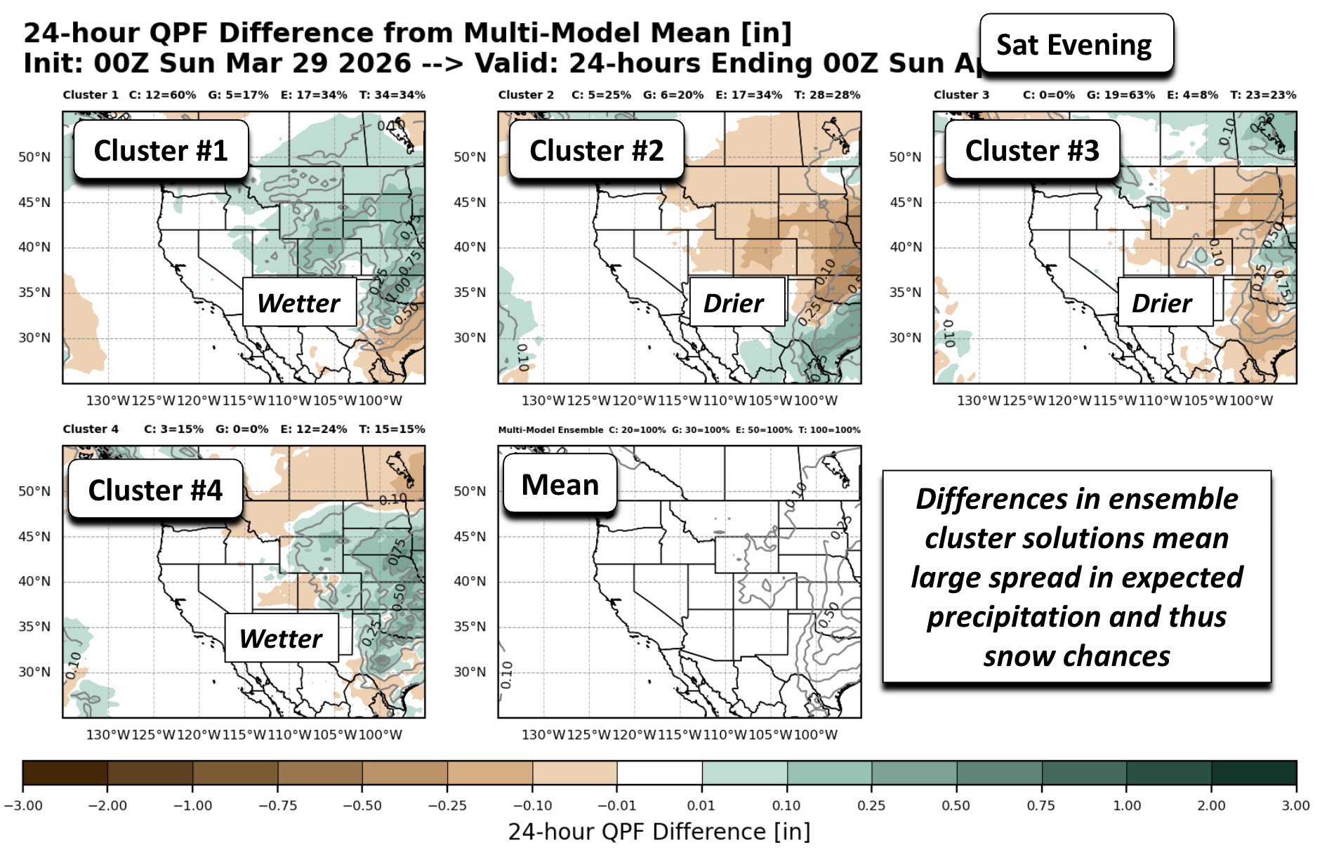
How do these differences translate to precipitation and snow chances? We can look at the same timeframe but for differences in precipitation with respect to the mean. Where the shading is green indicates the possible solution is wetter than the mean, and where it is drier would be brown. The slower and deeper to further south solutions (top two clusters above) are not surprisingly wetter, favoring that higher rain/snow chance for the Boulder-Denver area and Colorado’s Mountains. But the further north and faster solutions are drier (cluster #3 most evident).
Looking into Saturday, the differences unsurprisingly become larger. The #1 scenario, containing about 34% of ensemble members, shows a slower and deeper trough, similar to cluster #4. Cluster #2 is very fast, with the trough well east and ridging already bringing warmer air. Cluster #3 is faster than the first and also drier with its trough location along the Canadian border.
Similarly, we can look at the precipitation differences on Saturday. The further south and slower solutions (clusters #1 and #4), representing about 45% of the possible ensemble members, are wetter and favor a higher snow chance. But clusters #2 and #3 are notably drier with the northern track and ridging building in with the faster exit.
To summarize the cluster analysis:
- Clusters 1 & 4 (deeper, slower troughs)
- Trough positioned farther west or southwest
- Wetter solutions with higher rain/snow potential for the Front Range
- Clusters 2 & 3 (faster, farther north)
- Trough lifts into the northern Plains
- Drier outcomes with ridging building in quickly
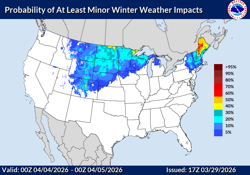
Bottom Line: Confidence remains low for late‑week precipitation, but the setup is worth monitoring — especially given our desperate need for moisture. The Weather Prediction Center currently shows low‑end probabilities for minor winter impacts in the Boulder–Denver corridor. Whether it ends up being rain or snow, any precipitation would be beneficial.
Our initial gut feeling says we’ll probably see a few wet snowflakes to end the week, but nothing to write home about. Stay tuned, though, this late-week pattern has plenty of moving parts.
Forecast Specifics:
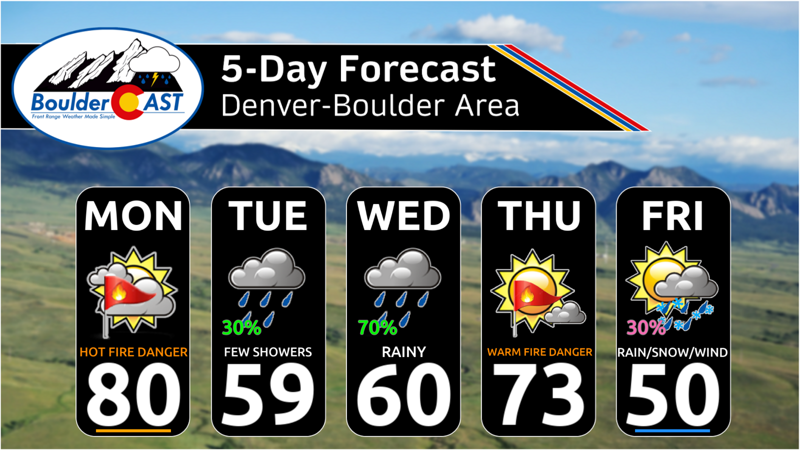
Monday: Record warmth, gusty winds, and very dry with Red Flag conditions. Highs near 80 for the Plains and 70 in the Foothills.
Tuesday: Much cooler and cloudy. Morning drizzle possible. Otherwise, a chance of late day and evening spotty showers. Highs in the upper 50s on the Plains and middle 40s in the Foothills.
Wednesday: Mostly cloudy with numerous afternoon and evening scattered showers. A few isolated storms are possible. Highs near 60 for the Plains and upper 40s in the Foothills.
Thursday: Breezy, warmer, and possible high fire danger, dependent on rainfall the prior days. Highs in the lower 70s on the Plains and near 60 in the Foothills.
Friday: Mostly cloudy. A chance of rain or snow late in the day. Strong gusty winds likely. Highs in the 40s to lower 50s.
Weekend: Mostly cloudy with a chance of rain or snow Saturday into early Sunday. Highs may trend colder/warmer but for now expect low 50s in the Denver Metro and low 40s in the Foothills.
DISCLAIMER: This weekly outlook forecast is created Monday morning and covers the entire upcoming week. Accuracy will decrease as the week progresses as this post is NOT updated. To receive daily updated forecasts from our team, among many other perks, subscribe to BoulderCAST Premium.
Go Premium, get all the perks.
Daily Forecast Updates
Get our daily forecast discussion every morning delivered to your inbox.
All Our Model Data
Access to all our Colorado-centric high-resolution weather model graphics. Seriously — every one!
Ski & Hiking Forecasts
6-day forecasts for all the Colorado ski resorts, plus more than 120 hiking trails, including every 14er.
Smoke Forecasts
Wildfire smoke concentration predictions up to 72 hours into the future.
Exclusive Content
Weekend outlooks every Thursday, bonus storm updates, historical data and much more!
No Advertisements
Enjoy ad-free viewing on the entire site.
Enjoy our content? Give it a share!


You must be logged in to post a comment.