Meteorological winter wrapped up in the most 2025–26 way possible: not with snow, but with a wildfire at the base of the Flatirons—an unsettling bookend to what has been Boulder’s warmest winter on record by a wide margin. This week keeps the volatility going, with a near‑record warm Monday, a sharp cool‑down and rain on Tuesday, and a second late‑week system that could bring snow for everyone depending on how the trough organizes. It’s a classic early‑March pattern with warm spells, cold fronts, and plenty of uncertainty. Read on as we break down what to expect throughout the highly variable week of weather ahead in the Front Range.
This week’s highlights include:
- 🔥 Winter ended with a wildfire, as the Bluebell Fire ignited at the base of the Flatirons in Boulder—an unsettling but fitting finale to a season that never acted like winter.
- 🍃 Calm winds saved the day, allowing crews to contain the fire quickly; it burned just 1.5 acres, a small outcome that could’ve been far worse given the prior windy, dry stretch.
- 🌡️ Boulder just logged its warmest winter on record, beating 1980–81 by more than a full degree—an extraordinary margin in climate terms.
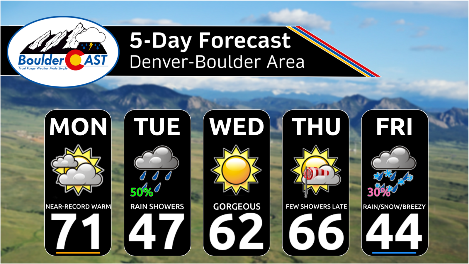
- ☀️ Monday surges into the low 70s, flirting with the 1901 record of 75°, with warm southwest flow and lingering fire risk despite light winds.
- 🌧️ Storm #1 arrives Tuesday, flipping temps back below normal with cool upslope, light rain on the Plains, and 2–6 inches of new Mountain snow.
- ❄️ Storm #2 targets late week, with a broad, uncertain trough that guarantees Mountain snow but leaves Plains snowfall highly track‑dependent.
- 📉 Friday turns colder, with highs in the 40s (or 30s if stronger solutions verify) and mixed rain/snow possible depending on how the trough evolves.
- 🌱 The weekend rebounds, trending dry and milder with 40s–50s Saturday and 50s–60s Sunday—classic early‑March weather as meteorological spring begins.
DISCLAIMER: This weekly outlook forecast is created Monday morning and covers the entire upcoming week. Accuracy will decrease as the week progresses as this post is NOT updated. To receive daily updated forecasts from our team, among many other perks, subscribe to BoulderCAST Premium.

Go Premium, get all the perks.
Daily Forecast Updates
Get our daily forecast discussion every morning delivered to your inbox.
All Our Model Data
Access to all our Colorado-centric high-resolution weather model graphics. Seriously — every one!
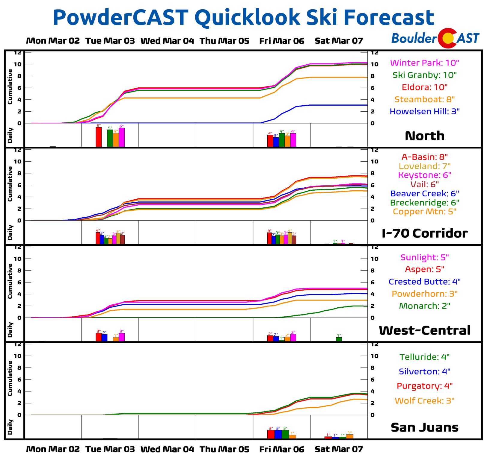
Ski & Hiking Forecasts
6-day forecasts for all the Colorado ski resorts, plus more than 120 hiking trails, including every 14er.
Smoke Forecasts
Wildfire smoke concentration predictions up to 72 hours into the future.
Exclusive Content
Weekend outlooks every Thursday, bonus storm updates, historical data and much more!
No Advertisements
Enjoy ad-free viewing on the entire site.
Goodbye, “winter”—or whatever that was.
Meteorological winter wrapped up on Saturday, and it exited with a very on‑brand occurrence for 2025–26: not with snow, not with cold, but with a wildfire at the base of the Flatirons. The Bluebell Fire sparked Saturday afternoon west of Chautauqua, a jarring but fitting punctuation mark on a season that never truly behaved like winter in Boulder.
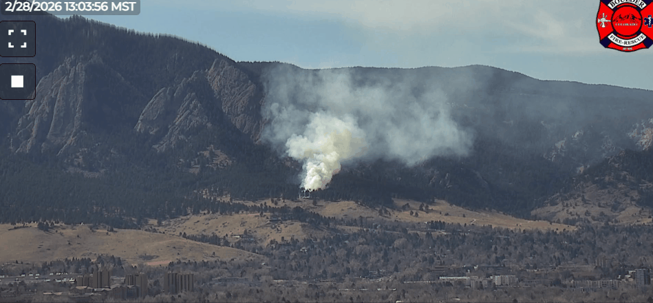
The only good news: it ignited during one of the only calm, wind‑free afternoons we’ve had lately. Had this fire started on any of the four preceding warm, dry, windy days, we’d be sharing a much very different story with you today. Instead, with light winds and quick response from ground and air crews, the fire crept only minimally and was contained at 1.5 acres of Boulder Open Space. A small burn, but a big reminder of how precarious things have become across Boulder County and the broader Front Range. The exact cause of the Bluebell Fire remains under investigation, be we have a pretty good guess… 🚬
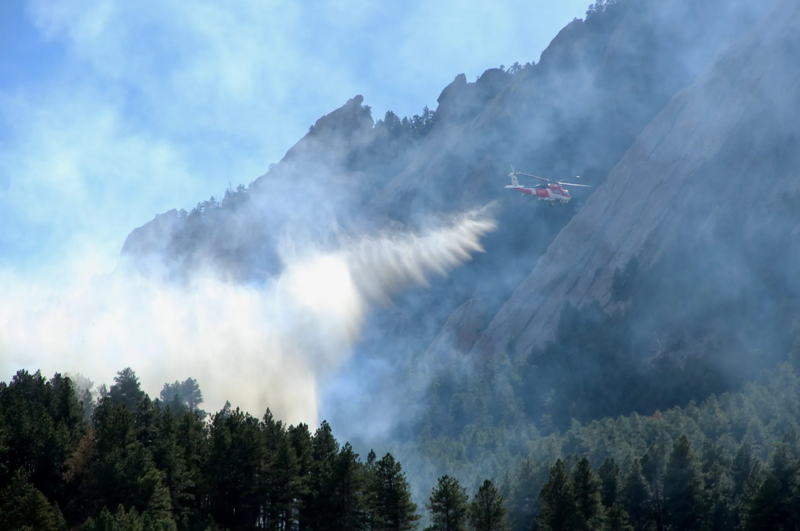
Photo by Brooke Stephenson via Boulder Reporting Lab
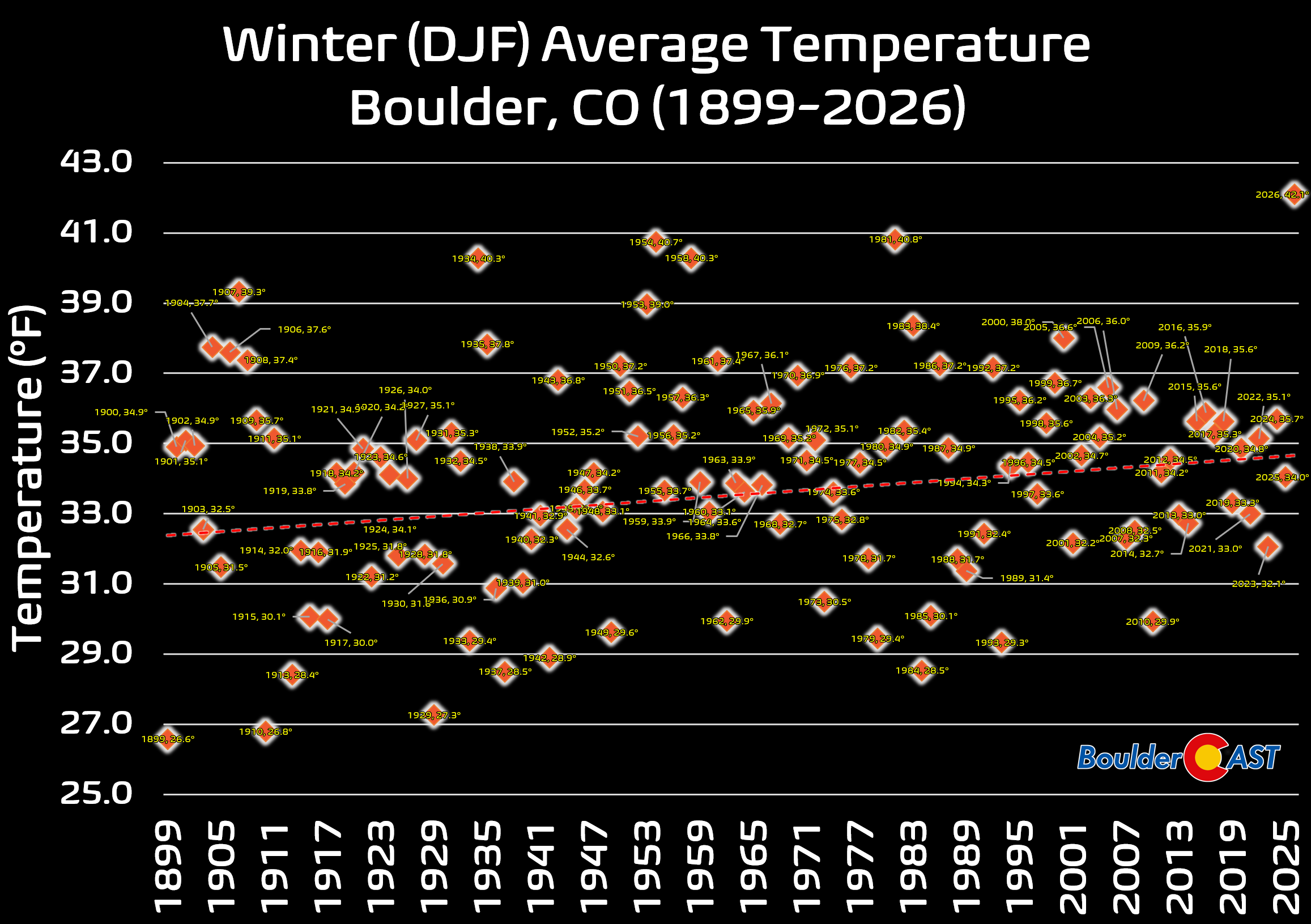
Final numbers still need to be quality‑controlled, but all signs point to this winter being Boulder’s warmest on record, beating the previous champ (1980–81) by more than a full degree. That’s not a narrow win—that’s a blowout when you’re talking about the average temperature across three entire months.
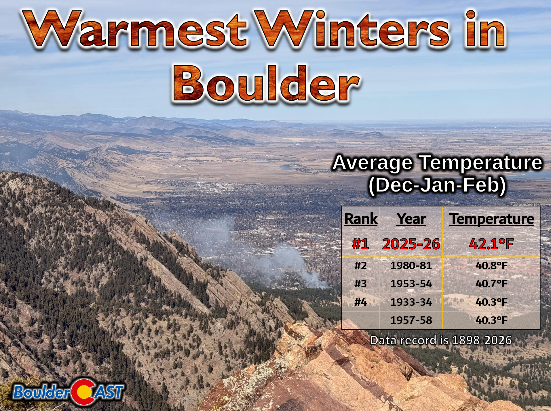
Photo credit: Reddit user 0ctetz.
We’ll dig into this record‑shattering winter season in a dedicated post later this week or next. For now, enjoy this historical timeline of average winter (December–February) temperatures—a visual reminder of just how far we strayed from anything resembling “normal” this year.
A near-record warm Monday
March wastes no time continuing the theme. A low over southwest Wyoming and a warm front stretching across the central Plains will pump a healthy southwest flow into Colorado on Monday.
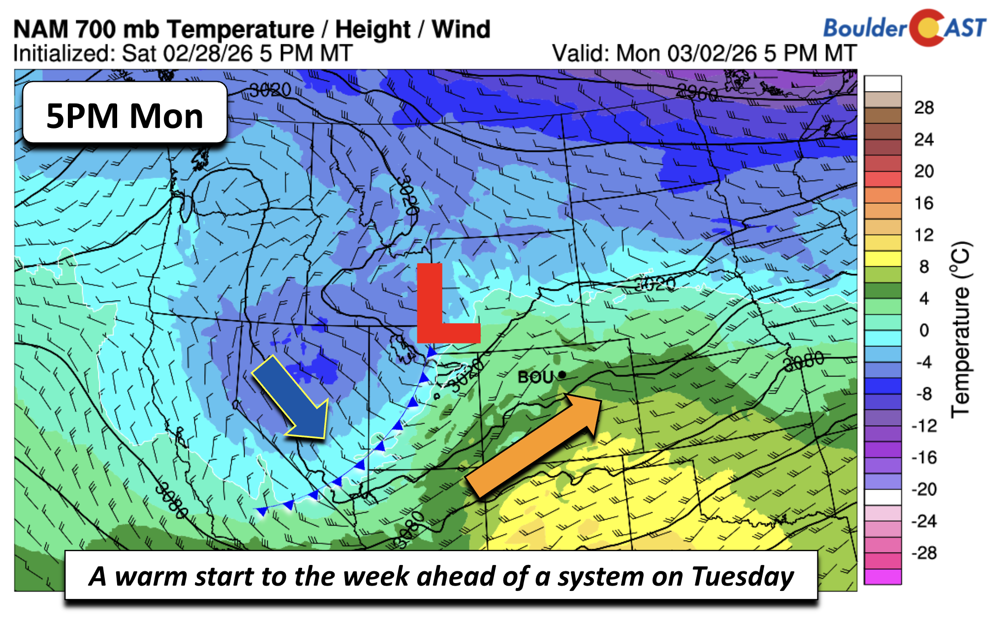
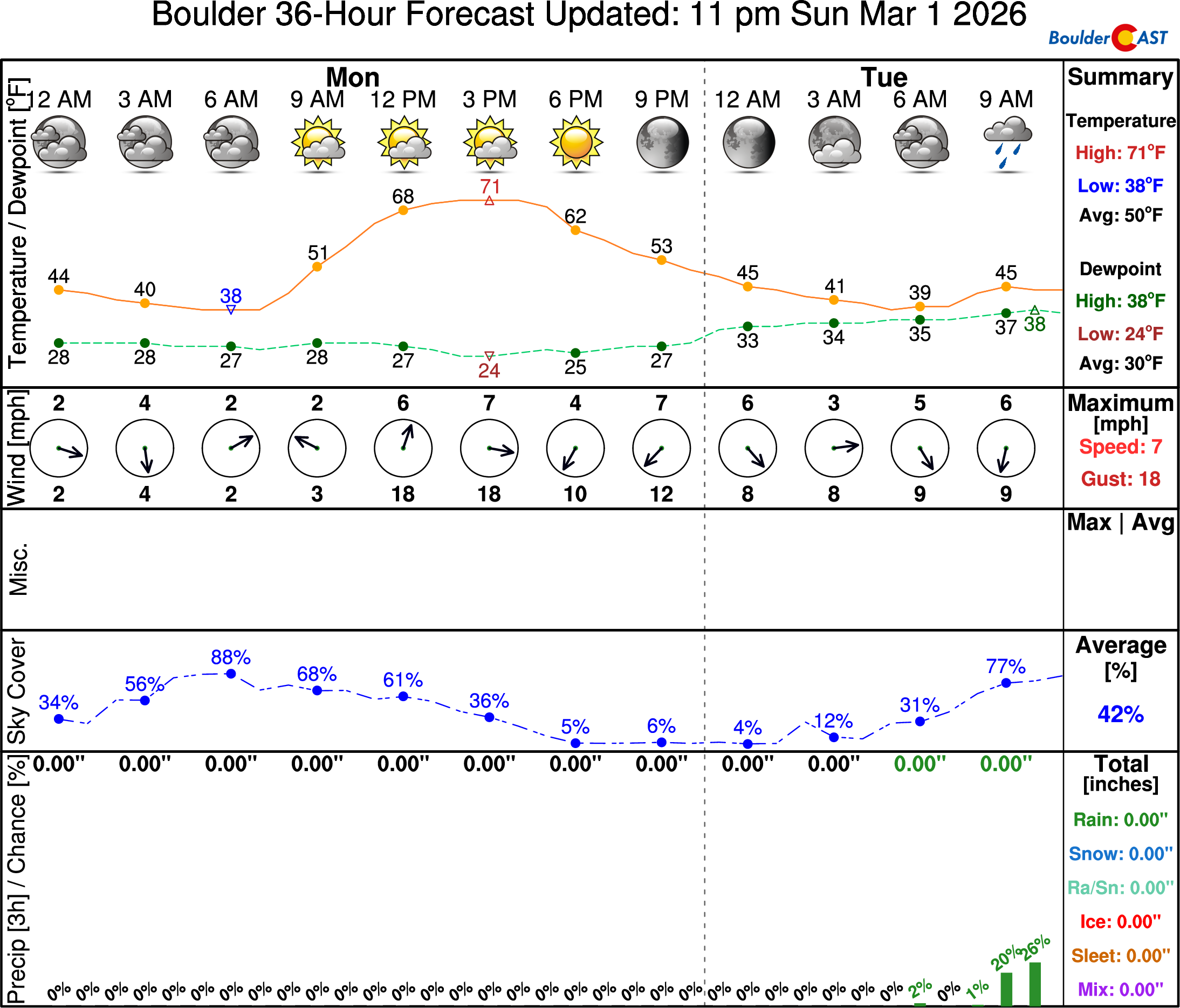
Temperatures in Boulder should surge into the lower 70s—warm, but likely shy of the 75° record from 1901. Fire danger isn’t extreme to start the week due to non-existent winds, but the landscape is still parched and primed to burn. Even on a “low‑risk” day, it doesn’t take much to start trouble as we saw over this past weekend. Be careful out there!
Fortunately, as we go through the remainder of the week, we will see a few shots of precipitation, the first being Tuesday, and then another later this week late Thursday through Friday. The first system looks to be all rain, while the latter event could bring a little bit of the white stuff.
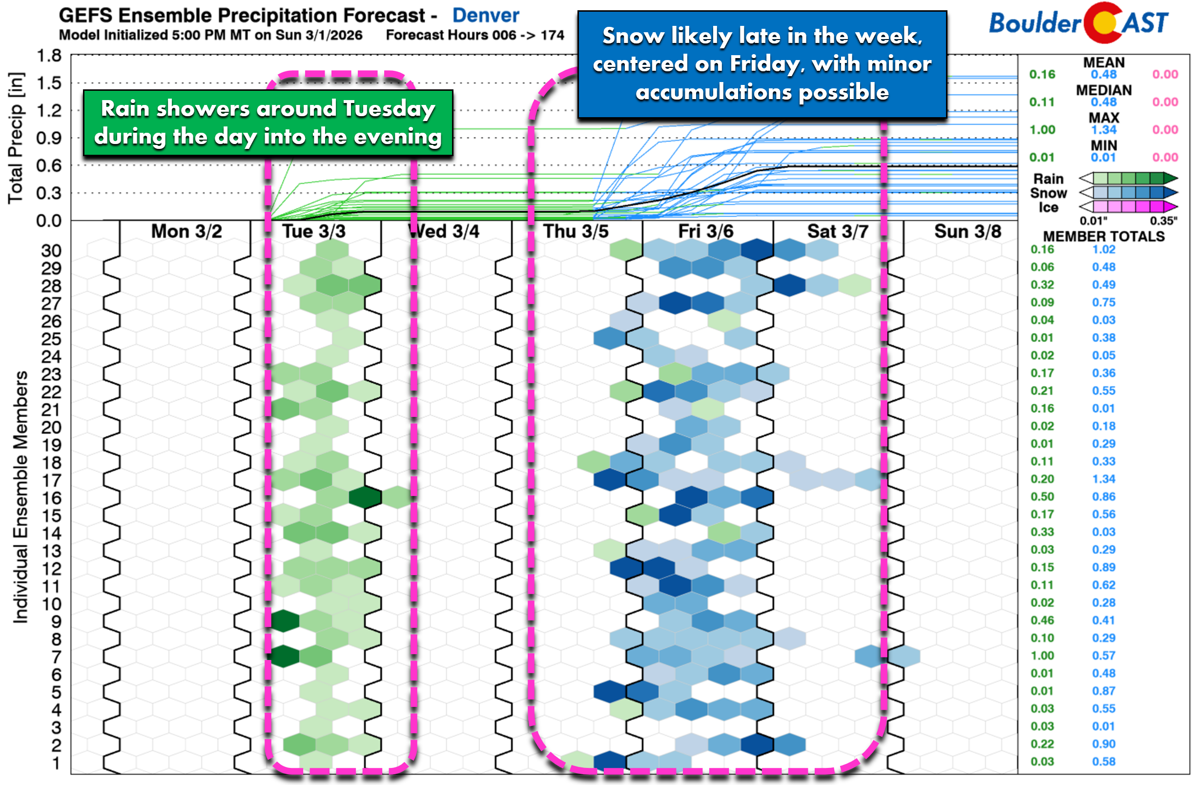
Storm #1: Rain showers Tuesday with Mountain snow
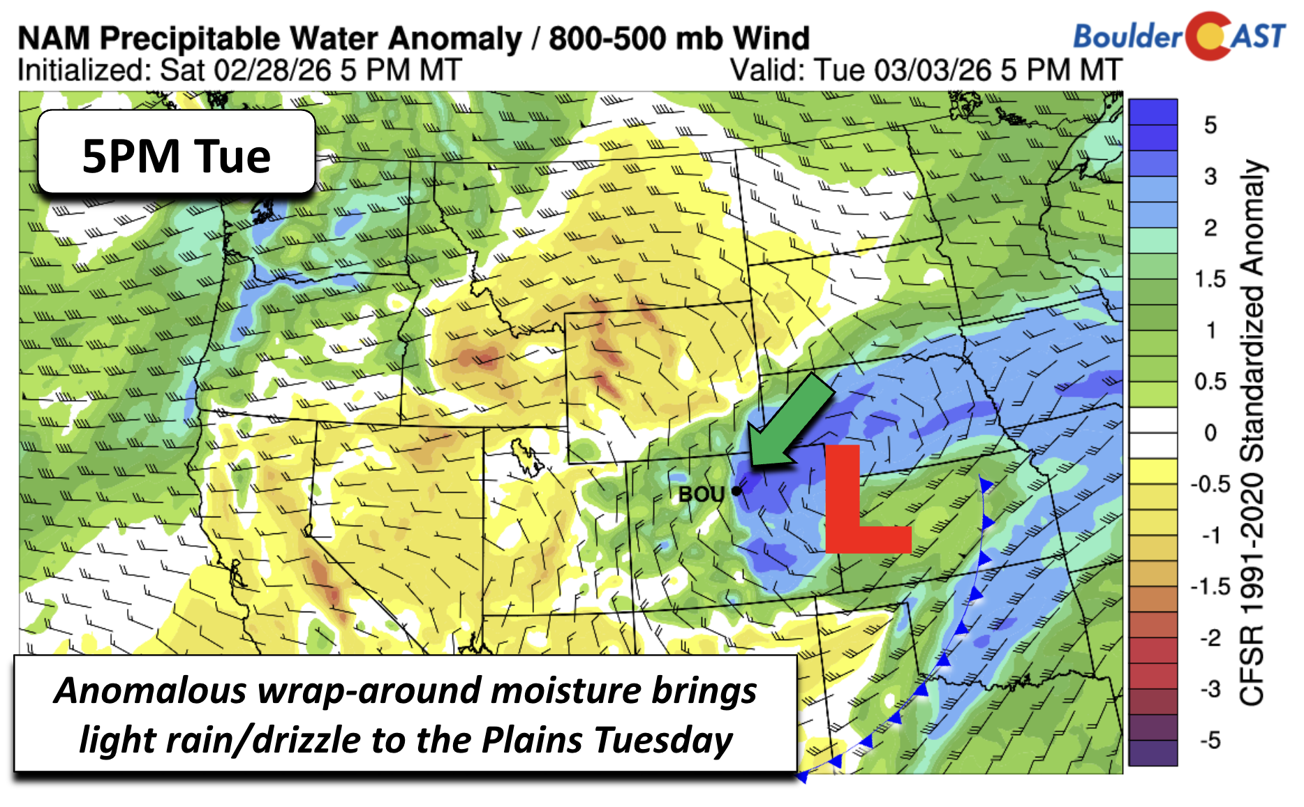
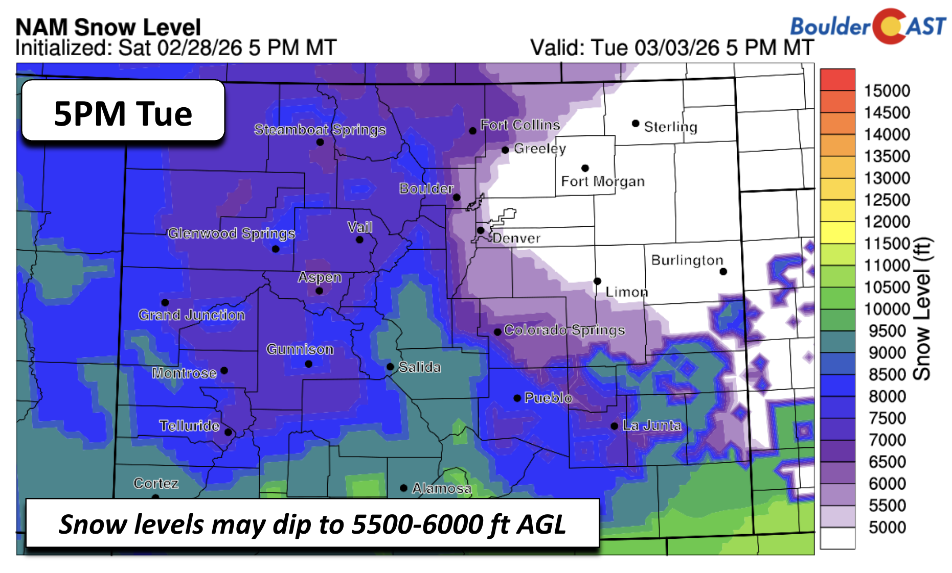
If Monday feels like early May, Tuesday snaps us back to reality. The same system responsible for Monday’s warmth slides east and drags in cool, moist upslope flow from the north and northeast. It’ll be our first legitimately chilly, gray, damp day in weeks.
For Tuesday, expect:
- Highs in the upper 40s to low 50s on the Plains
- Upper 30s in the Foothills
- Rain and drizzle for the lower elevations
- A brief window of wet snow above ~7000 feet in the Foothills
- Little to no accumulation east of Denver where temperatures may cool enough to turn rain to snow
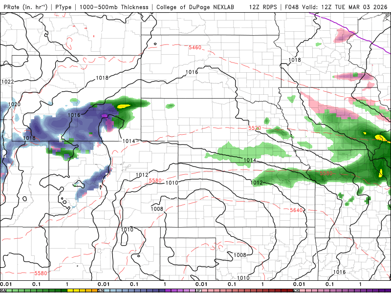
Below shows the Canadian Regional model depiction of precipitation across the area Tuesday into Tuesday night. The best chance of rain for us on the Plains will be during the afternoon hours, when the low pressure system tracks east of the Mountains and brings in the moist upslope flow. Rainfall amounts are not expected to be that helpful to the dry conditions, with most areas seeing a tenth of an inch or less. Though, we would not be surprised if a few locales see up to a quarter inch with springtime instability in play for localized convection. All in all, Tuesday’s rain won’t be a drought buster but we’ll take whatever we can get.
In the Mountains, this is the third straight week of fresh snow. Resorts along the central and northern ranges should pick up 2 to 6 inches Tuesday, with more possible later in the week.
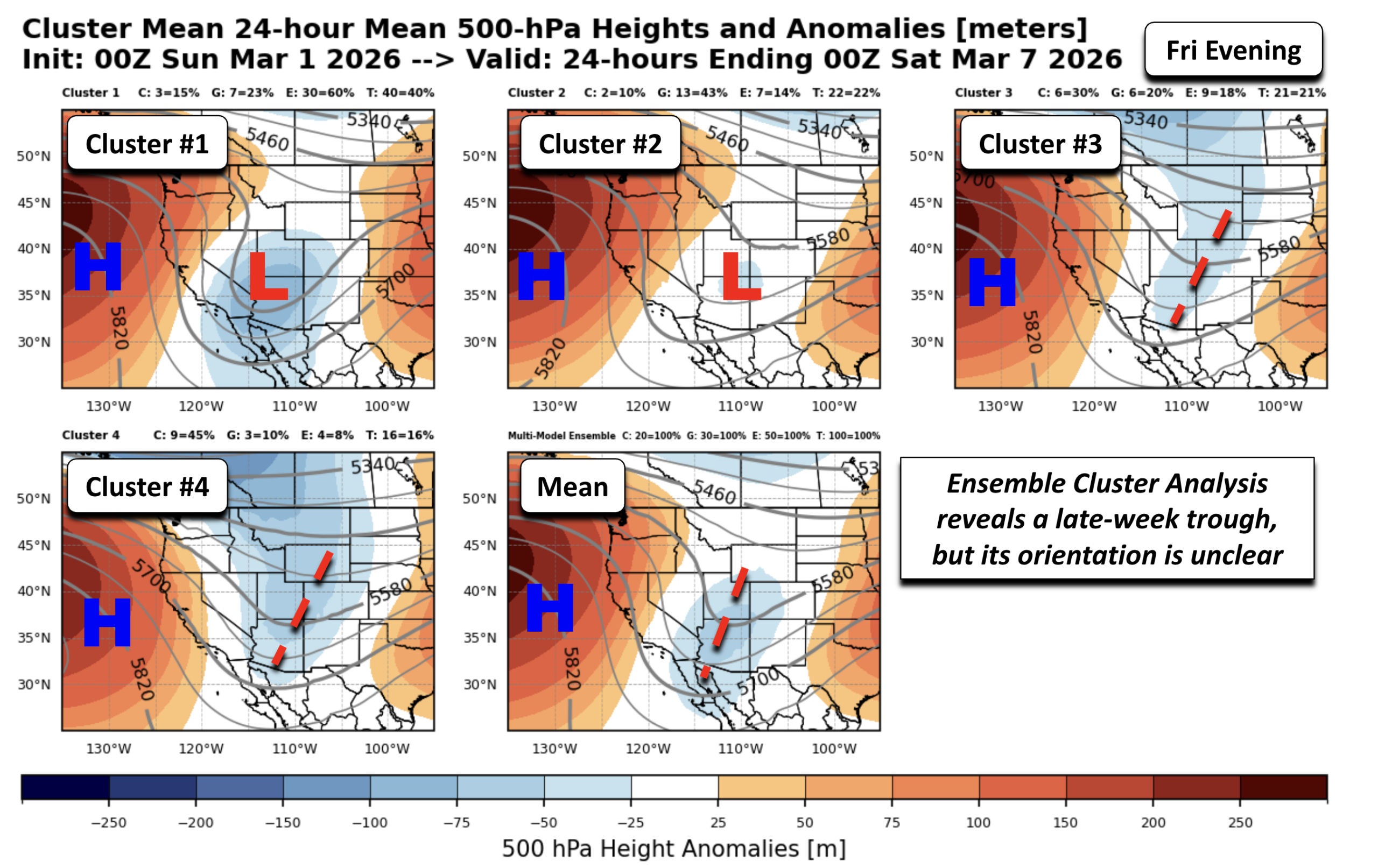
Storm #2: Late-week snow chances for everyone
Wednesday rebounds nicely into the 60s, but the calm won’t last. A broad, somewhat disorganized trough approaches Thursday into Friday, dragging a cold front south and knocking temperatures back into the 40s.
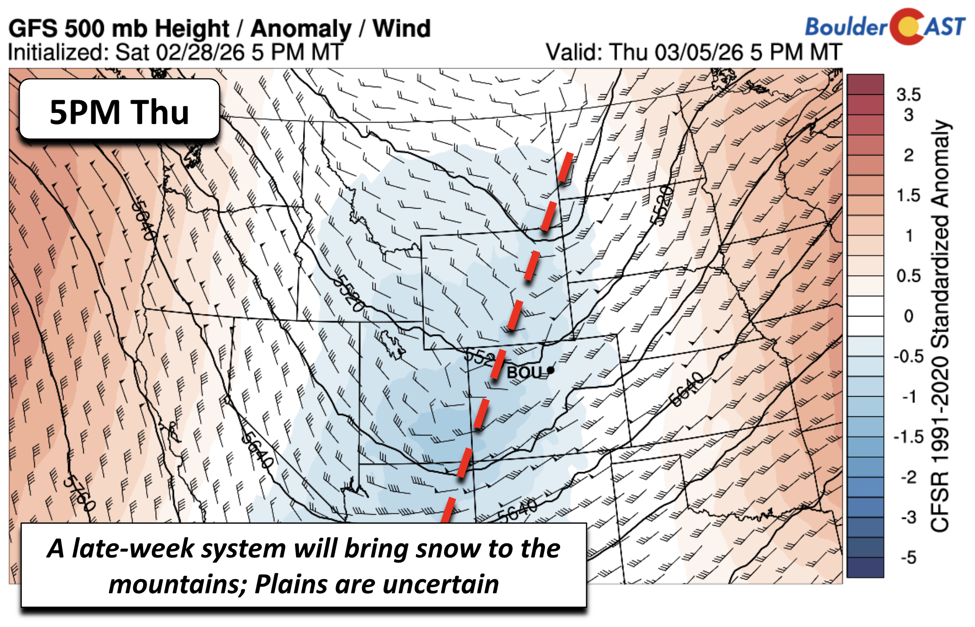
The exact orientation of this trough is still fuzzy this far out:
- Some ensemble clusters show a more developed wave near the Four Corners—which would be better for Plains snow.
- Others support a broader, weaker, positively‑tilted trough—less exciting for snow lovers in the Boulder-Denver area.
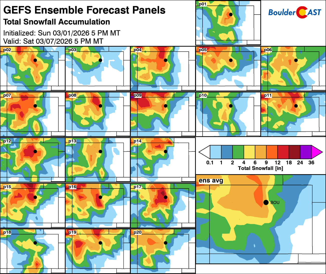
Mountain snow is a near‑certainty either way, with ensemble guidance suggesting 4–12 inches total through Saturday (including Tuesday’s storm). For the Plains, most ensemble members do produce some snow, but amounts vary wildly. Current ensemble means are:
- GFS: 3 to 5 inches for Boulder
- Euro: ~2 inches
There’s also a non‑zero chance that part of the late‑week precip falls as rain, especially if the colder solutions don’t verify. This late-week system will definitely be something we watch closely through the week for its snowfall potential, so stay tuned.
Highs on Friday will be the low to middle 40s, or 30s if stronger/colder solutions verify. Temperatures this weekend trend upward again—40s to 50s on Saturday, 50s to low 60s by Sunday—under dry skies. This week’s weather pattern is typical for early spring in the Front Range: warm spells, cold fronts, scattered precipitation chances, and plenty of uncertainty. Welcome to March and meteorological spring!
Winter may be over on the calendar, but March is indeed our snowiest month of the year. We’re hopeful, but not optimistic, that we can squeeze some meaningful moisture out of this week’s two‑part pattern shift. The ingredients are there—cooler air, upslope flow, and a couple of passing troughs—but the setups remain messy, shallow, and far from the big spring storms that can bury the Front Range. Still, even light to moderate precipitation would help chip away at the dryness left behind by our record‑warm winter, and the Mountains look poised for yet another week of decent snowfall regardless. March has a way of surprising us, for better or worse, and the coming days will give us our first real test of whether the atmosphere is ready to pivot toward something more seasonally generous. Stay tuned and subscribed for updates!
Forecast Specifics:
Monday: Partly to mostly cloudy and quite warm for the Plains with lower 70s, just shy of record highs. The Foothills will see temperatures in the lower 60s.
Tuesday: Overcast with light rain and drizzle, especially by the afternoon hours. Temperatures a few degrees below normal in the upper 40s on the Plains, to upper 30s in the Foothills. A few periods of wet snow are possible in the Foothills above 7,000 feet but with little accumulation expected (trace to 2 inches).
Wednesday: Becoming sunny with highs back to above normal in the low to middle 60s on the Plains and lower 50s in the Foothills.
Thursday: Increasing clouds with highs in the low to middle 60s for the Plains and low 50s in the Foothills with the approach of a cold front. A few rain showers may develop late in the day or during the evening.
Friday: Trending cooler by week’s end with a chance of snow. Highs in the low to middle 40s in the Denver Metro and middle 30s in the Foothills.
Weekend: Dry and quiet weather is expected for the weekend with highs gradually trending above normal in the 50s to lower 60s. The next shot of unsettled weather may come early next week
DISCLAIMER: This weekly outlook forecast is created Monday morning and covers the entire upcoming week. Accuracy will decrease as the week progresses as this post is NOT updated. To receive daily updated forecasts from our team, among many other perks, subscribe to BoulderCAST Premium.
Go Premium, get all the perks.
Daily Forecast Updates
Get our daily forecast discussion every morning delivered to your inbox.
All Our Model Data
Access to all our Colorado-centric high-resolution weather model graphics. Seriously — every one!
Ski & Hiking Forecasts
6-day forecasts for all the Colorado ski resorts, plus more than 120 hiking trails, including every 14er.
Smoke Forecasts
Wildfire smoke concentration predictions up to 72 hours into the future.
Exclusive Content
Weekend outlooks every Thursday, bonus storm updates, historical data and much more!
No Advertisements
Enjoy ad-free viewing on the entire site.
Enjoy our content? Give it a share!


You must be logged in to post a comment.