As we head into the second week of March, Mother Nature will offer up a wide range of weather in the Front Range, including elevated fire danger, unseasonably warm temperatures, and an impressively strong spring storm system by Friday. The late-week storm will usher in Mountain snow and widespread strong winds to the state. Depending on how things evolve, blizzard conditions and blowing dust may be an issue east of Denver, but things aren’t looking too bad in our immediate area. Read on for all the details.
This week’s highlights include:
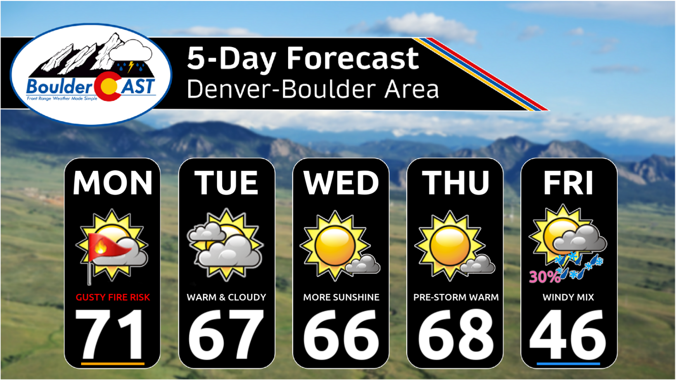
- Fire Danger on Monday: Gusty west winds up to 30 MPH on Monday will create elevated fire danger as highs soar to 70 degrees.
- Quiet & Warm Midweek: Tuesday through Thursday will be beautiful in the Front Range with highs in the 65 to 70° range and no chance of precipitation.
- Late Week Bomb Cyclone Brings Mostly Wind: A strong storm will impact Colorado late in the week, but it’s rapid movement and track will favor mostly just wind in our area, with just brief rain/snow possible. Impacts will be greater in the Mountains (windy snow) and eastern Plains (strong winds, blowing dust, slight chance of blizzard conditions).
- Tame Weekend: Quiet conditions will return for the weekend, with cool & breezy weather Saturday trending warmer for Sunday.
DISCLAIMER: This weekly outlook forecast is created Monday morning and covers the entire upcoming week. Accuracy will decrease as the week progresses as this post is NOT updated. To receive daily updated forecasts from our team, among many other perks, subscribe to BoulderCAST Premium.

Go Premium, get all the perks.
Daily Forecast Updates
Get our daily forecast discussion every morning delivered to your inbox.
All Our Model Data
Access to all our Colorado-centric high-resolution weather model graphics. Seriously — every one!
Ski & Hiking Forecasts
6-day forecasts for all the Colorado ski resorts, plus more than 120 hiking trails, including every 14er.
Smoke Forecasts
Wildfire smoke concentration predictions up to 72 hours into the future.
Exclusive Content
Weekend outlooks every Thursday, bonus storm updates, historical data and much more!
No Advertisements
Enjoy ad-free viewing on the entire site.
Warm & gusty Monday with elevated fire danger
We begin the week under the influence of the same high pressure which brought us the beautiful conditions over the weekend. The one change for Monday is that there will be a weak disturbance passing through Montana creating an increased pressure gradient across Wyoming and Colorado, and as a result, an uptick in westerly winds in the Front Range.
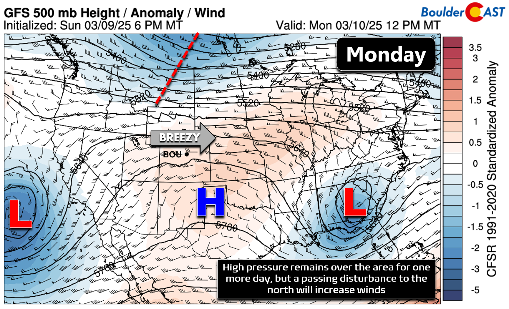
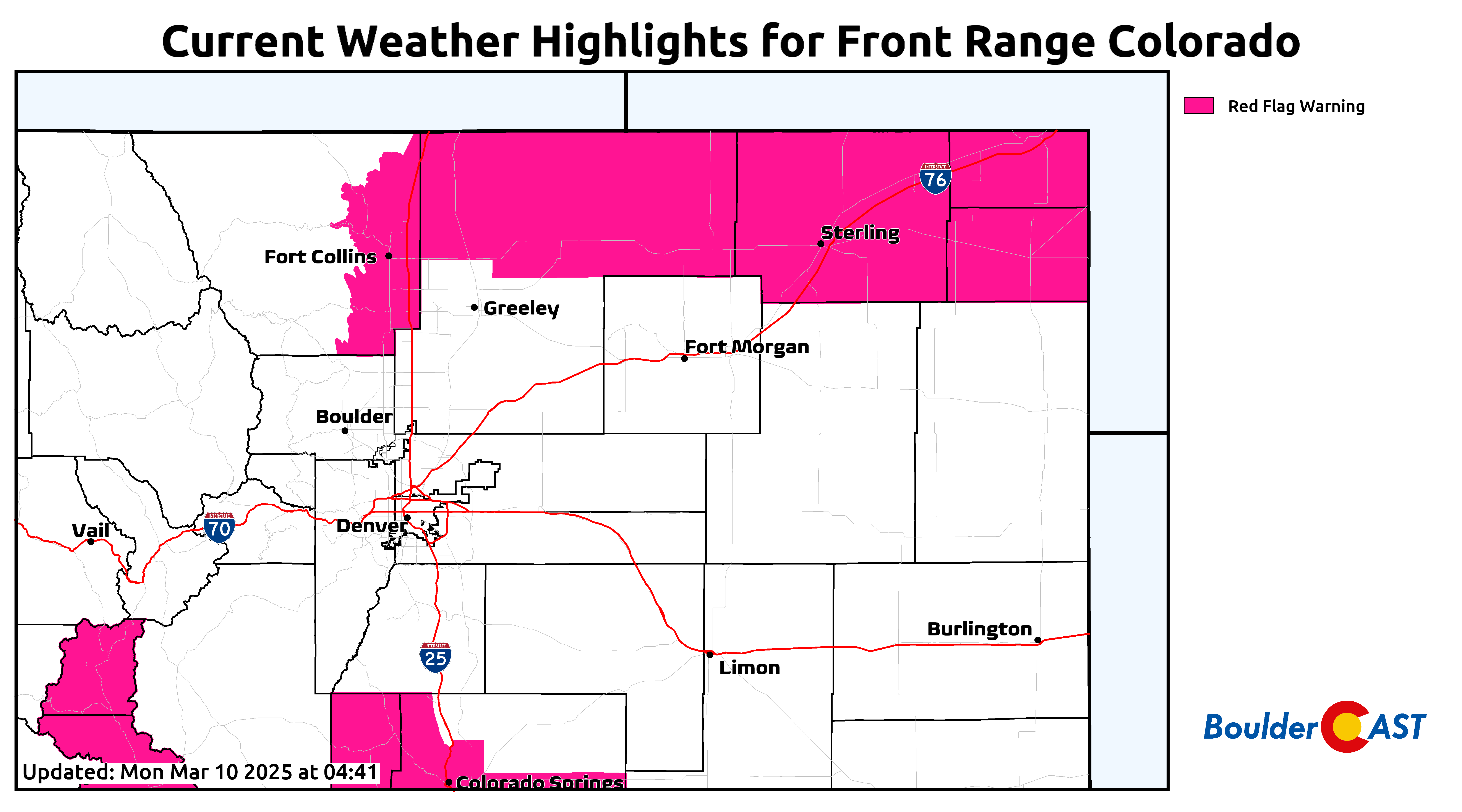
Winds gusting 20 to 30 MPH during the day will create elevated fire danger as temperatures rise into the lower 70s and humidity plummets below 15% areawide.
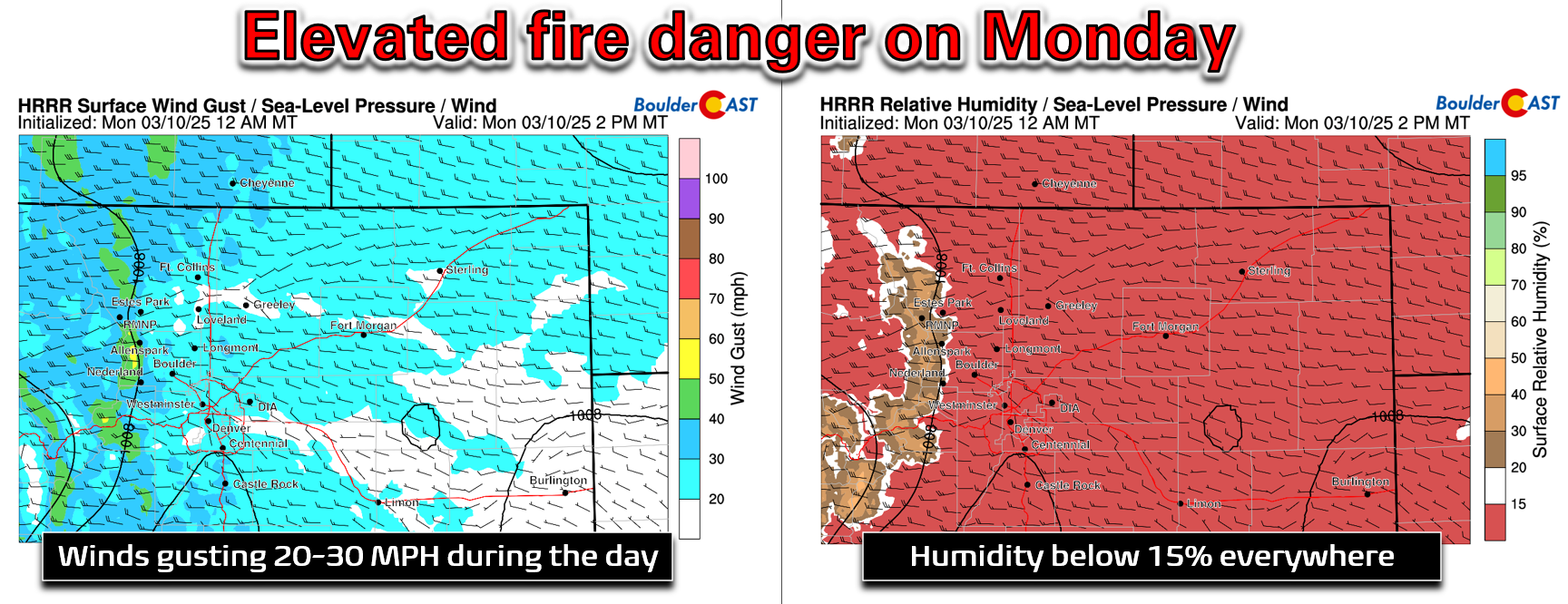
Larimer County will see slightly stronger winds on Monday, but also remains in drought, even Extreme Drought in some areas.
Red Flag Warnings are posted up in Fort Collins and eastward towards Nebraska where the best overlap in gusty winds and dry fuels will exist on Monday. Boulder and Denver are not included in this warning, but conditions will be borderline here as well for quick fire spread. Use caution with any and all flames and sparks!
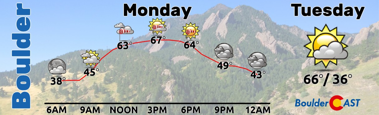
Monday will see high temperatures reach some of our warmest values yet in 2025, with most of us topping out right around 70 degrees in the Metro area. Gusty winds will be around of course, as well as varying amount of wave clouds.
Quiet Midweek
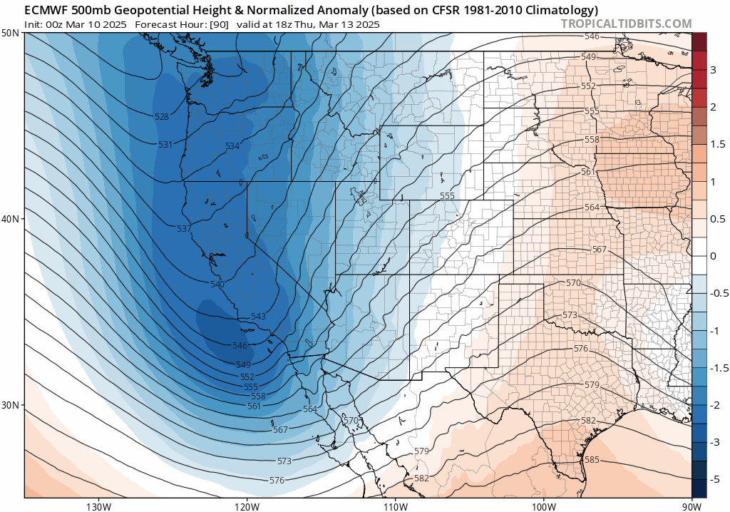
The middle of the week will see generally quiet conditions persist across Colorado. Though the pattern will turn slightly more active during this period, general ridging will still exist through Thursday. The 500mb animation below spans from Monday afternoon through Thursday morning. During this period, there will be a small and weakening cut-off low traversing across New Mexico with no real impacts here.
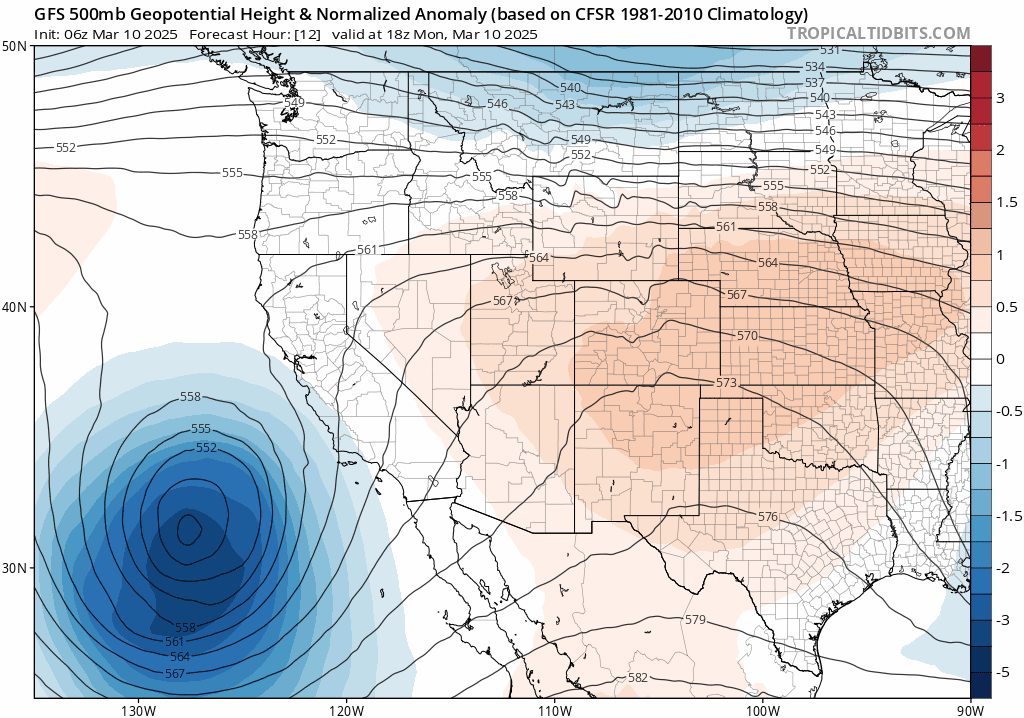
Tuesday will see us remain under the influence of the same early-week high pressure, but the core of the ridge will shift off to the east. This will take the absolute warmest air with it, but we’ll still see unseasonably mild temperatures unfold Tuesday afternoon as well, just not quite as warm as Monday. 700mb temperatures drop by 1.5°C relative to Monday which will translate into high temperatures in the Boulder-Denver area in the mid to upper 60s on Tuesday. Winds will be lighter but still a tad breezy with fire danger remaining somewhat elevated but nothing too bad.
Despite the New Mexico disturbance passing to our south mid-week, our temperatures will remain similarly warm Wednesday and Thursday in the 65 to 70° range. There’s no chance of precipitation in our area until Thursday night…
Late week bomb cyclone: Another miss for us!
If you haven’t heard the noise of the hype-train pulling into station for the spring storm system anticipated to hit Colorado later this week, well you haven’t missed much. The media has once again pushed hype through the roof for a storm that really doesn’t look all that impactful for the Denver area. Yes, there will be a big and rapidly intensifying southern-track low pressure moving across the southern Rockies later this week. It may even end up meeting the intensification criteria for a bomb cyclone — that is, a 24 millibar sea-level pressure drop in less than 24 hours — but the devil is always in the details here!
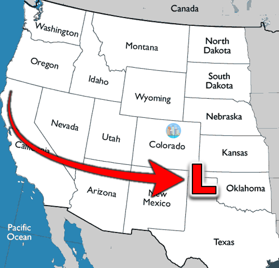
The Pacific trough coming ashore into northern California on Thursday will progress across Four Corners Thursday night before intensifying rapidly near the Oklahoma Panhandle area on Friday. The evolution of the trough and developing strong mid-level low are shown below. Note the track of the storm is quite far south and well-removed from the Denver area.
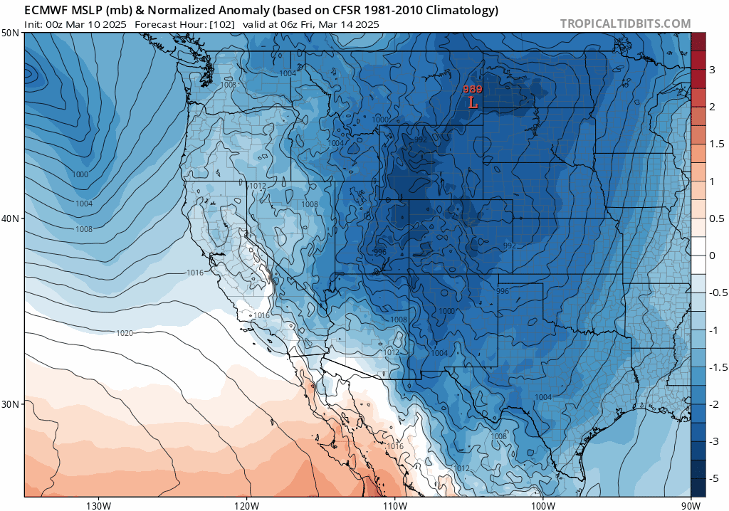
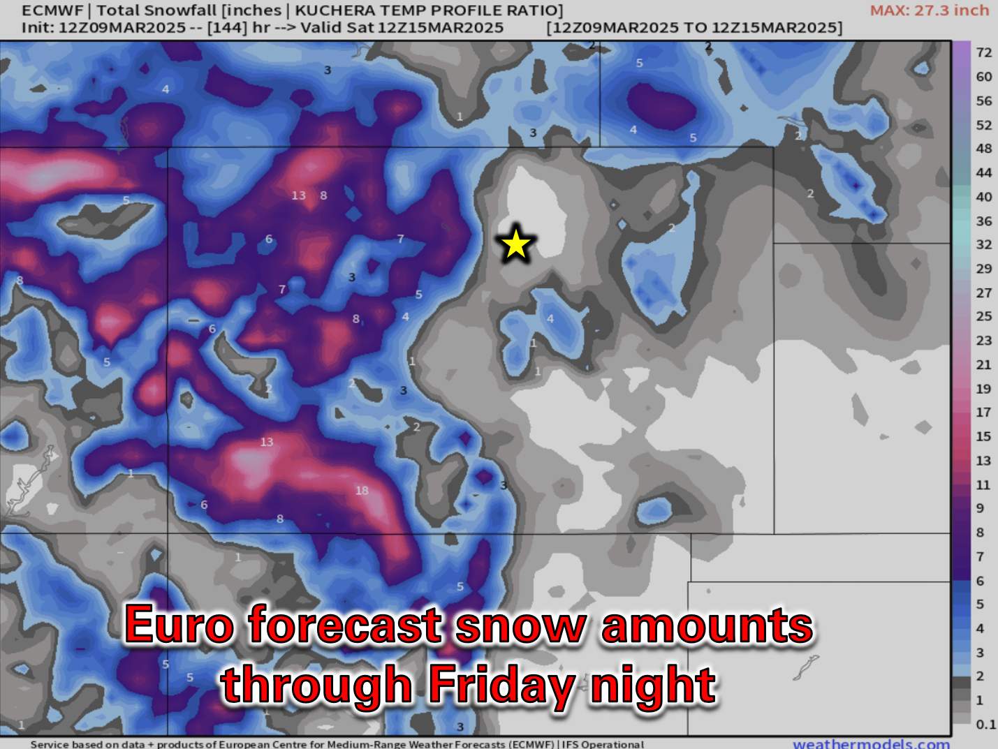
Unfortunately for us, the storm is moving rather quickly. Despite blowing up as it comes down off the Rockies (classic lee cyclogenesis!), it won’t have enough time to pull in significant moisture or upslope into Colorado before it’s already gone into the Great Plains. The Euro model’s predicted sea-level pressure forecast animatron below is for late-week. It’s currently advertising a central pressure around 978 millibars (!) for the low located in far southeast Colorado by Friday evening, with the pressure dropping further as it hurriedly heads towards the Great Lakes into the weekend.
The primary impact from this powerful storm is shaping up to be mostly wind across the Front Range and all of eastern Colorado, with wind-laden precipitation expected to be brief and relatively minor coming in the form of spotty rain showers Thursday night transitioning to a rain/snow mix or wet snow on Friday. Try to keep your expectations in-check for this one — both the GFS and European ensembles produce less than 1″ of snow in our area from this storm! The potential exists for a few inches of accumulating snow southeast of Denver, but that remains uncertain.

As mentioned, the bigger impact will be the powerful winds on Friday as low pressure quickly deepens across eastern Colorado. The Boulder-Denver area tends to be somewhat sheltered in these scenarios. The strongest winds will be further east, closer to the low pressure and away from the terrain where gusts over 50 MPH are highly likely later this week.
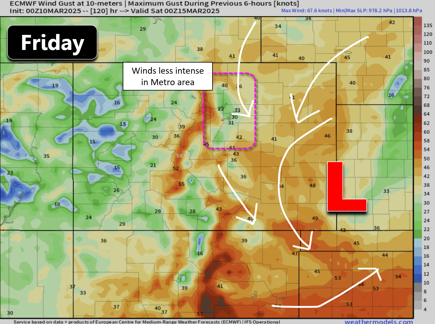
There’s still a fair amount of uncertainty in how this impressive storm will form and track, leading to some wiggle room in the peak intensity of winds for our immediate area on Friday. Most likely we see maximum gusts of 25 to 40 MPH, but there are some scenarios where we also get in on the 50+ MPH gusts, too. That would be most likely east of Interstate 25.

For now, we’re the bearer of somewhat good news. The late-week storm is shaping up to be more wind than anything, and not even that terrible of wind for us. We could certainly use the precipitation, but this just isn’t the storm to do that for us. There will definitely be travel impacts in the Mountains with several inches of wind-driven snowfall Thursday into Saturday across the gamut of mountain ranges, perhaps upwards of 1 to 2 feet in the San Juans. How things evolve east of Denver will need to be closely watched through the week. Even just a few inches of snow accompanying the intense winds could create blizzard conditions out there. In areas that don’t see any rain or snow, blowing dust will be a concern.
Ironically, Friday is the six year anniversary of the infamous O.G. Bomb Cyclone which pummeled eastern Colorado back in March of 2019 with widespread blizzard conditions. This week in particular has produced some of the biggest snowstorms for the Front Range in recent memory, including two massive mid-March dumps over just the last four years!
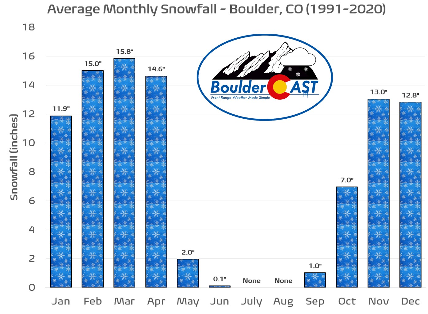
Contrary to popular knowledge, let this be your annual reminder that March is indeed our snowiest month of the year, with April not far behind! More snow will certainly arrive in due time, including a interesting looking storm around the middle of next week — it’s far too early to delve into that one yet, though.
Enjoy the stretch of beautiful days ahead but plan for colder and windier weather come Friday with a chance for minor rain/snow! Stay tuned…
Things quiet down for the weekend ahead, though we’ll stay chilly and gusty on Saturday with highs remaining in the 40s. A strong ridge will develop Sunday into early next week with temperature quickly returning into the 60s or better by Sunday.
Forecast Specifics:
Monday: Partly to mostly wave cloudy with westerly winds gusting 20 to 25 MPH. Dry fuels and low relative humidity will create elevated fire danger, especially north along the Wyoming Border. Highs reach 70 degrees on the Plains with upper 50s in the Foothills.
Tuesday: Quiet with afternoon breezes up to 15 MPH from the west. Lots of mid and high-level clouds are expected with highs reaching the upper 60s on the Plains with middle 50s in the Foothills.
Wednesday: Mostly sunny and warm with light winds. Temperatures reach the middle to upper 60s on the Plains with middle 50s in the Foothills.
Thursday: Staying warm and sunny with highs approaching 70 degrees during the afternoon on the Plains with upper 50s in the Foothills. Showers may develop Thursday night.
Friday: Still plenty of uncertainty regarding the late-week storm, but Friday should be much cooler with highs only in the 40s alongside gusty north-northwest winds of 20 to 40 MPH. There will also be a chance of rain/snow during the day with minor accumulations possible (less than 1″).
Weekend: Breezy in the 40s on Saturday, with quieter and warmer weather by Sunday in the lower 60s.
Get BoulderCAST updates delivered to your inbox:
DISCLAIMER: This weekly outlook forecast is created Monday morning and covers the entire upcoming week. Accuracy will decrease as the week progresses as this post is NOT updated. To receive daily updated forecasts from our team, among many other perks, subscribe to BoulderCAST Premium.
Go Premium, get all the perks.
Daily Forecast Updates
Get our daily forecast discussion every morning delivered to your inbox.
All Our Model Data
Access to all our Colorado-centric high-resolution weather model graphics. Seriously — every one!
Ski & Hiking Forecasts
6-day forecasts for all the Colorado ski resorts, plus more than 120 hiking trails, including every 14er.
Smoke Forecasts
Wildfire smoke concentration predictions up to 72 hours into the future.
Exclusive Content
Weekend outlooks every Thursday, bonus storm updates, historical data and much more!
No Advertisements
Enjoy ad-free viewing on the entire site.
Enjoy our content? Give it a share!


You must be logged in to post a comment.