The heat returns this week, but thankfully so do the storm chances. Highs start out near normal but reach potential record highs by midweek. Our storm chances increase Wednesday through Friday as better moisture spreads into the state, some of which will be tied to Tropical Storm Celia off the Baja coastline. Read on for all the details.
This week’s highlights include:
- Highs start out around normal but push towards potential record highs by Wednesday
- Storm chances increase Wednesday onward as better moisture spreads into the state with a trough out in the Pacific Northwest
- Congratulations to the Colorado Avalanche on their third Stanley Cup win! The celebratory parade is Thursday at 10 AM! Afternoon showers/storms are expected with highs in the upper 80s
- Storm chances remain elevated into the weekend as deeper moisture from Tropical Storm Celia may reach Colorado
- The tropics turn active this week with several features in each basin to keep an eye on

DISCLAIMER: This weekly outlook forecast is created Monday morning and covers the entire upcoming week. Accuracy will decrease as the week progresses as this post is NOT updated. To receive daily updated forecasts from our team, among many other perks, subscribe to BoulderCAST Premium.

Congrats to the Colorado Avalanche!
We wanted to first off congratulate the Colorado Avalanche for winning the 2022 Stanley Cup last night! This is their 3rd career Stanley Cup Win. A celebratory rally/parade will take place this Thursday at 10:00AM. Our current forecast calls for developing thunderstorms in the afternoon for the rally. Beforehand, highs will be in the upper 80s for the parade. More details can be found below.

Warming up with a slight chance of storms early week
An examination of the ensemble data for the week highlights two main stories for the weather ahead: heat and storms. The GEFS temperature forecast (below) shows that we’ll see an uptick in highs from Sunday into Wednesday. You’ll notice a downward trend after Wednesday with highs falling from the 90s into the middle 80s by week’s end.

That downward trend in highs, to more normal conditions, is related to an increased potential of showers/storms from Wednesday through the weekend. Let’s go in more detail on how this will all play out.
High pressure will largely be situated to our east on Monday at the surface.
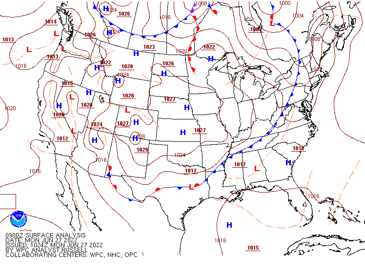
At mid-levels, a ridge will be over Utah. While a few weak shortwaves will traverse around the ridge into Colorado from the northwest, we’ll largely remain dry with just a 20% chance of storms on Monday with highs rising back to normal in the middle 80s. The best chance of storms is from 3PM to 7PM Monday afternoon.
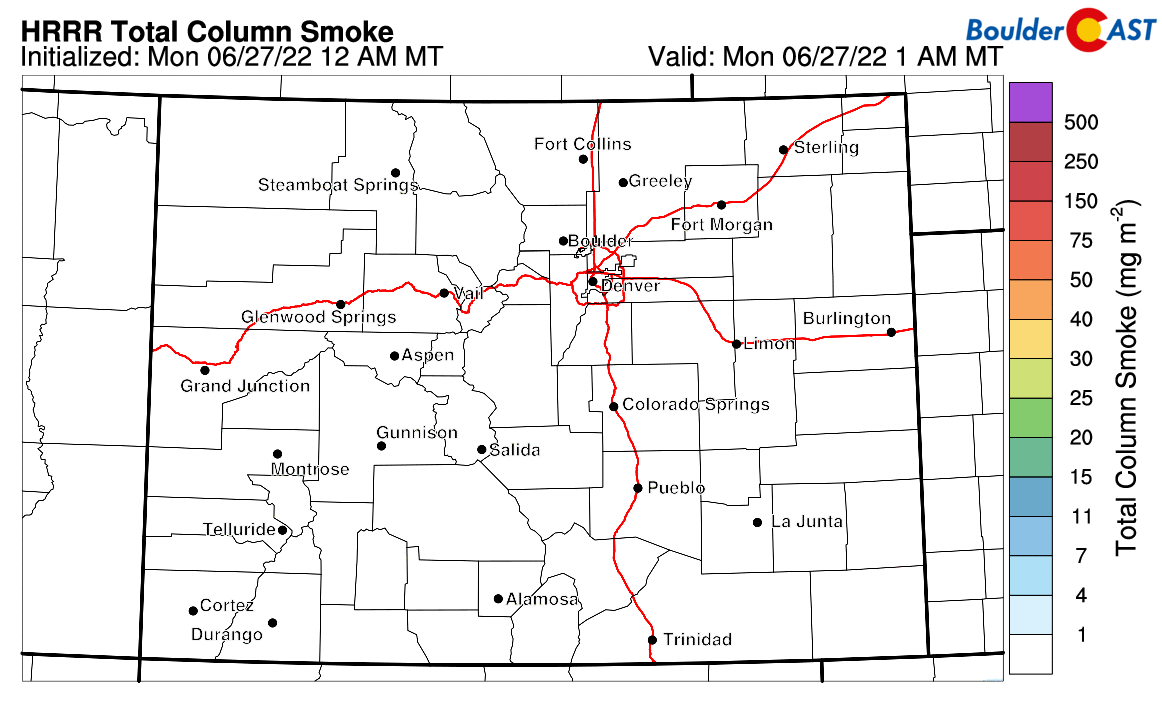
The HRRR smoke model depicts some smoke reaching western and central Colorado today from Utah. However, there are currently no active uncontained fires in Utah so our confidence on that actually happening today is low.
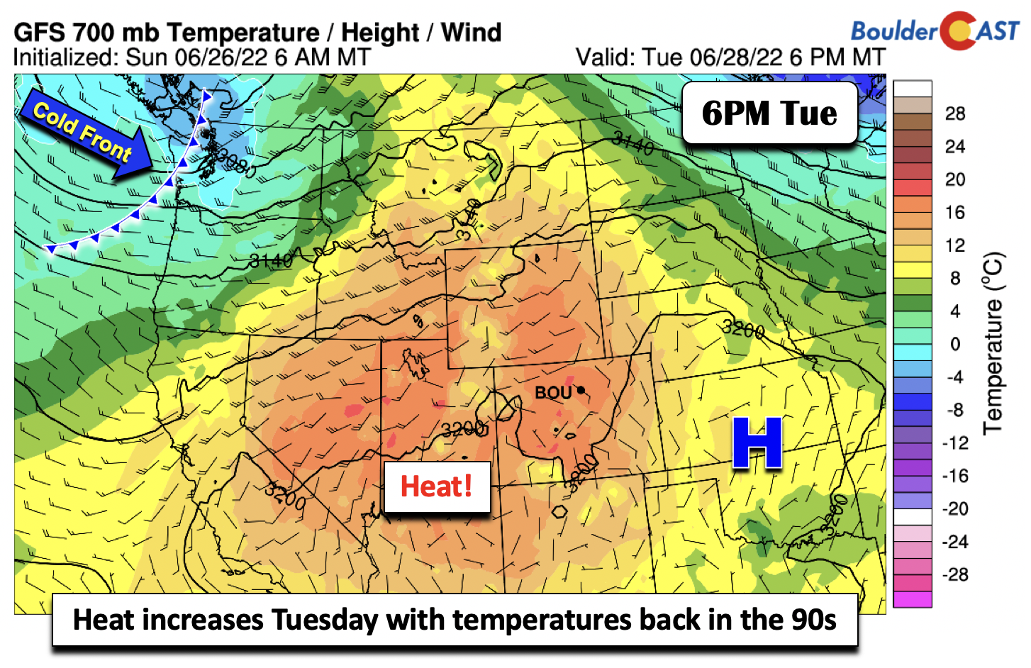
Heat will increase Tuesday as warmer mid-level temperatures spread further into Colorado from the southwest. Surface high pressure will largely remain in-place over central to eastern Kansas. We’ll continue to see a slight chance of some afternoon/evening storms, but most activity should reside along/west of the Continental Divide, where moisture and lift are more prevalent. Highs will be back above normal in the lower 90s.
Keeping an eye on the tropics
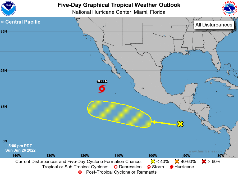
We are watching a few tropical systems this week — one in the Pacific and another in the Atlantic. The one in the Pacific, Tropical Storm Celia, is expected to drift northwest of Baja California over the coming days. However, guidance suggests some of the moisture from Celia may encroach into the southwestern USA by late week and for the weekend — this will be something to watch for our area as we get closer as it could lead to an uptick in storm chances and the potential for heavier rains throughout the Four Corners.
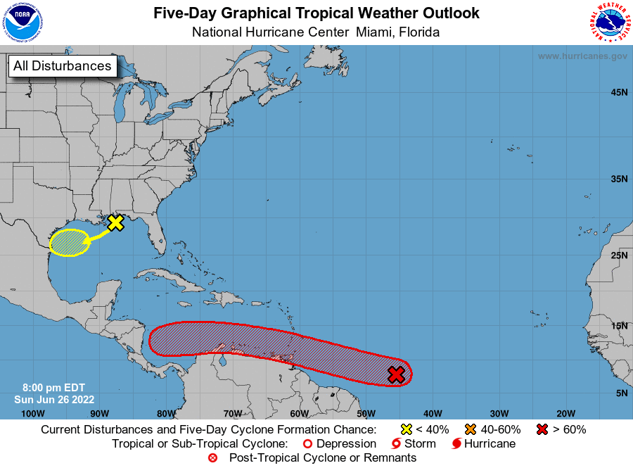
In the Atlantic, there is a disturbance over the north-central Gulf of Mexico that will track southwesternward later in the week and could develop into a system over the southern Plains. A secondary system well out in the Atlantic has a high chance (> 60%) of becoming a tropical system in 5 days as it tracks westward.
Record heat Wednesday? Storm chances increase mid to late week
Come Wednesday, the heat will continue to build further east and overspread much of the state and the central Great Plains. Model guidance would suggest middle 90s for highs around Denver, but it is certainly plausible we could see some upper 90s given the very warm airmass. However, increasing storms and clouds during the afternoon would make reaching record levels difficult. For reference, though, the record high temperature for Boulder on Wednesday (June 29th) is 99°F set back in 1953.
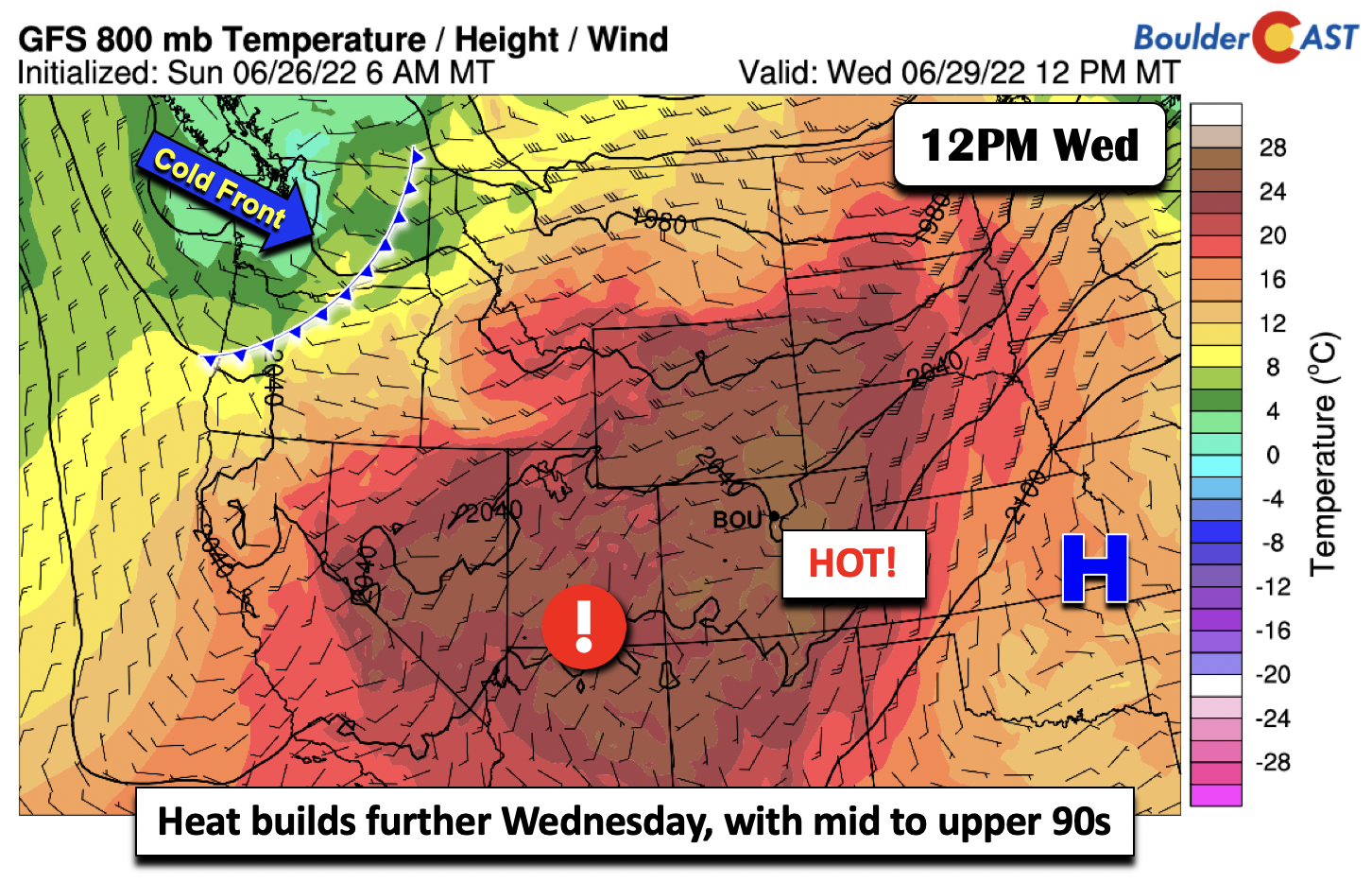
Along with the heat Wednesday, a trough extending from just north of Montana into Washington state will enhance shortwave energy along and north of Colorado. This trough will eventually force a southward moving cold front on Thursday.
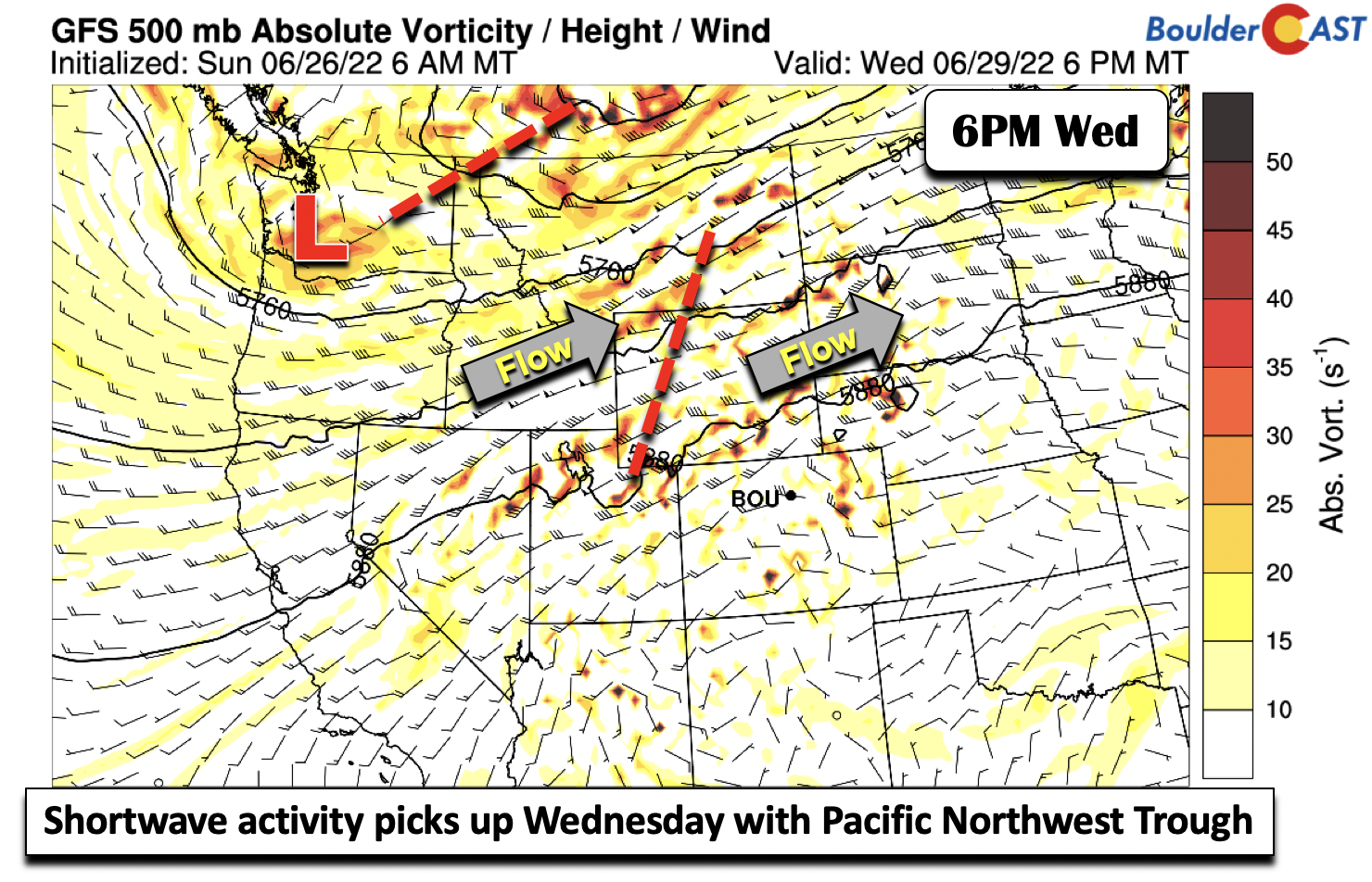
The southwest flow that will enhance on Wednesday as a result of the ridge to our east and the trough to our northwest will allow anomalous (sub)tropical moisture to spread into the area from the Baja and Arizona. Expect around a 30% chance of storms Wednesday, peaking in the afternoon/evening and decaying by late evening.

Some of the influx of moisture, while uncertain, may be sourced from Tropical Storm Celia as early as Thursday as the flow remains largely from the southwest into Colorado. However, the better chance of tropical moisture from Celia would come this weekend as the tropical low approaches closer to the West Coast. Nevertheless, anomalous precipitable water will remain Thursday.
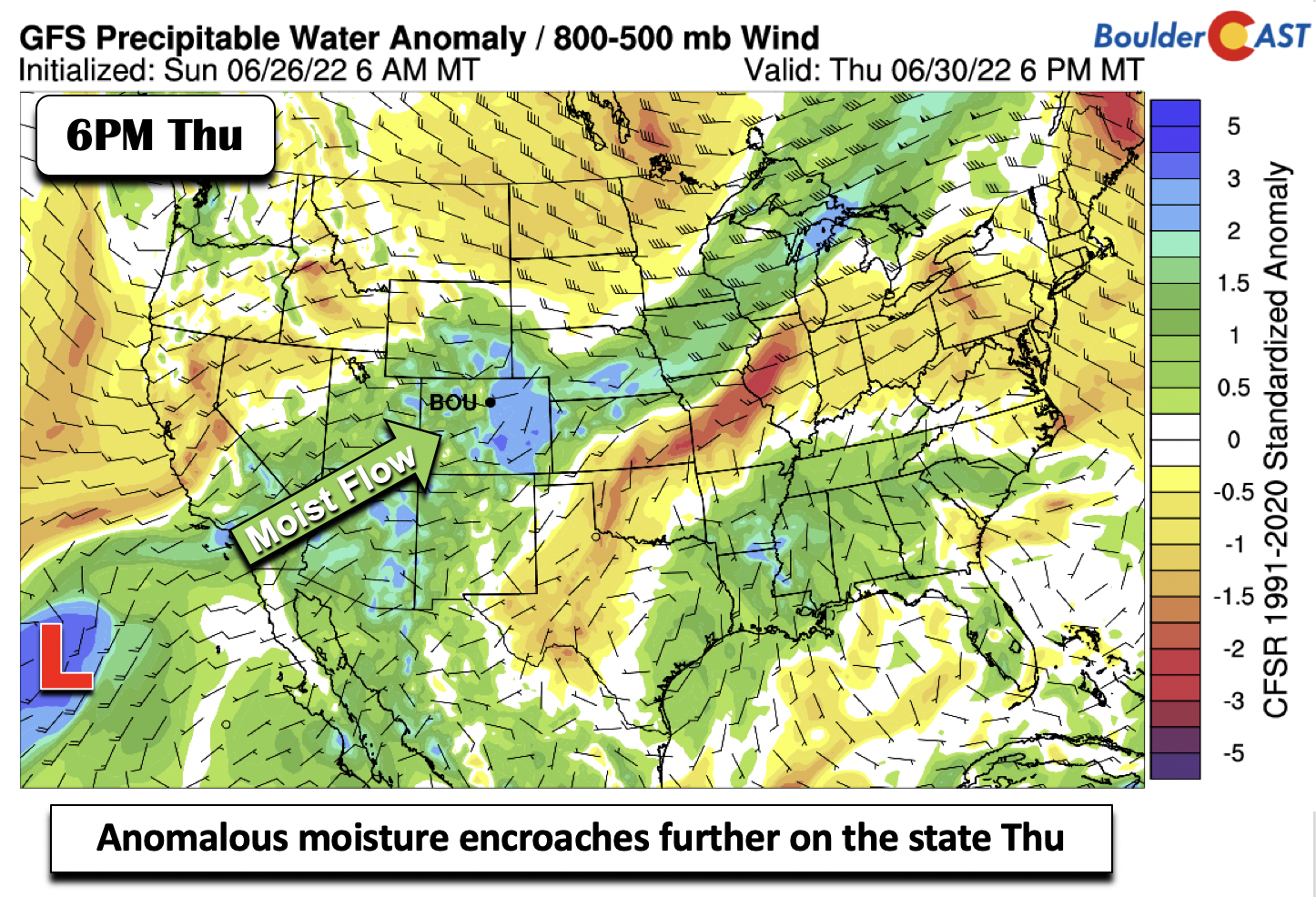
Along with the continued high moisture content Thursday, a cold front will move through the area during the afternoon/evening from the north. So not only the moisture but increased lift should favor our highest storm chances on this day (50-60%). Unfortunately, this is also the day of the Avalanche parade and rally. Be prepared by wearing cool clothes and having a jacket/umbrella handy with afternoon/evening storm development. Highs are expected to be closer to average in the upper 80s to near 90 degrees.

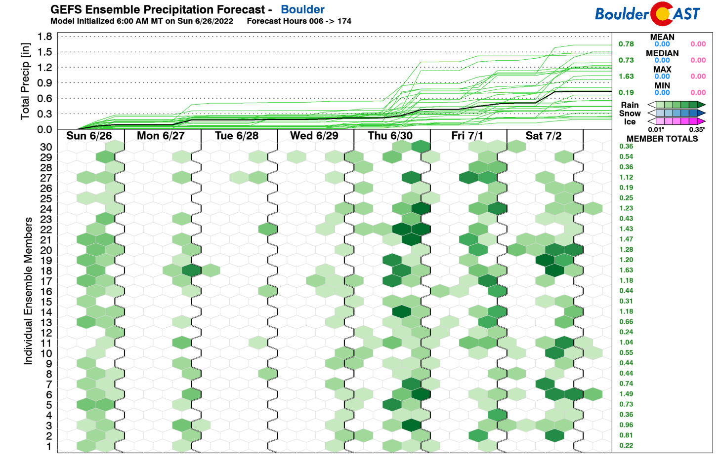
Our weather will continue to remain active Friday— a 30-40% chance of afternoon/evening storms — with the front nearby and moisture remaining elevated with a monsoonal type flow from the south and southwest. Precipitation amounts from the GFS by early Saturday could range from a quarter to three quarters of an inch, with greatest amounts in the High Country (upwards of 2 inches).
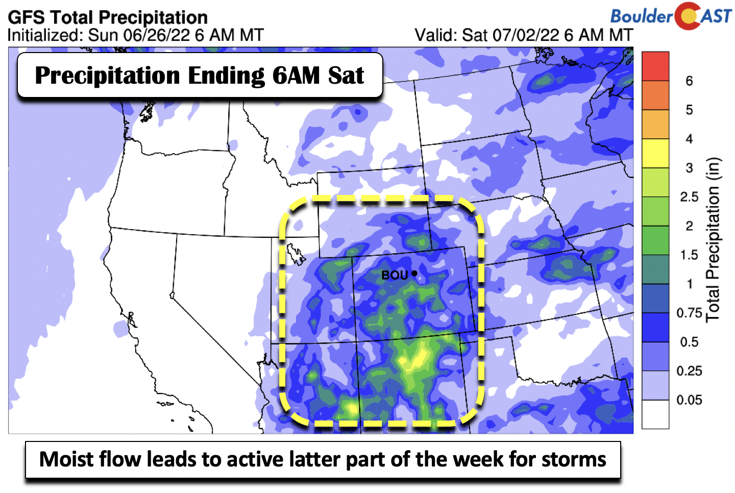
Looking further ahead, we expect little change for the weekend. The GEFS ensembles are honing in on a trough off the West Coast and a mid-level ridge over New Mexico/Texas.

This will favor a continued moist monsoonal flow into the state. Expect diurnal showers/storms and highs rising back into the 90s by the late weekend and early next week.

Today is the 10 year anniversary of the #FlagstaffFire in #Boulder. 🔥 It was sparked by a monsoon lightning strike amidst a terrible statewide drought. In the end, the wildfire burned about 350 acres and forever changed the landscape of Bear and South Boulder Peaks #cowx pic.twitter.com/LrvPfdVLNa
— BoulderCAST Weather (@BoulderCAST) June 26, 2022
Stay up to date with Colorado weather and get notified of our latest forecasts and storm updates:
Forecast Specifics:
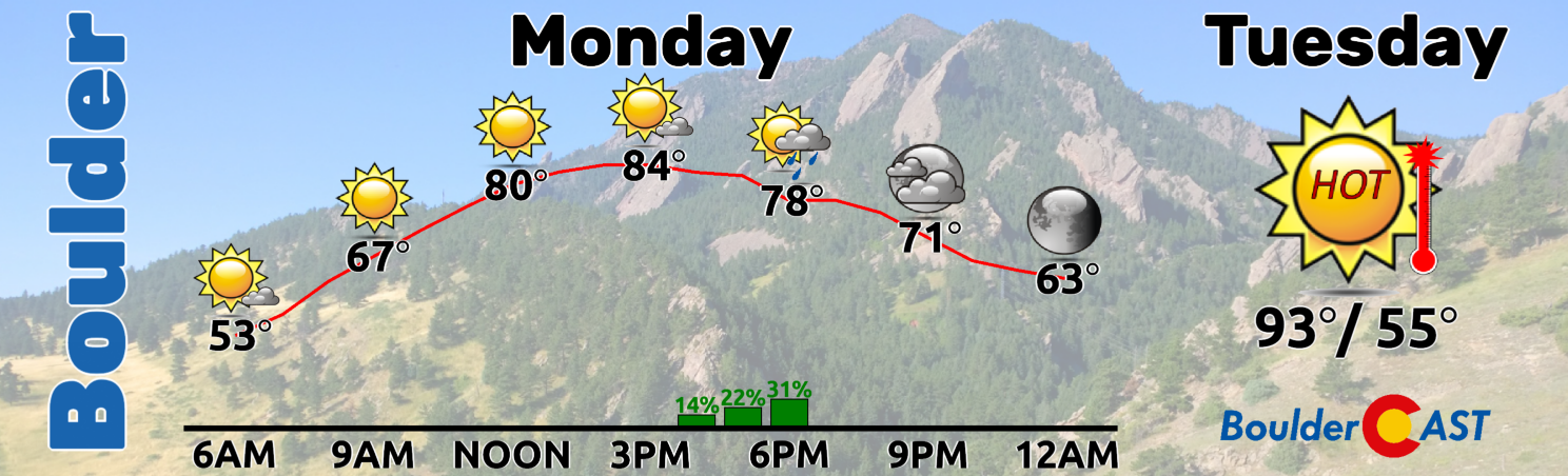
Monday: Highs rising back into the mid to upper 80s on the Plains and lower 70s over the Foothills. A slight chance of afternoon/evening storms.
Tuesday: A chance of afternoon/evening storms with highs above normal in the lower 90s on the Plains and low 80s in the Foothills.
Wednesday: A better chance of showers and storms in the afternoon/evening. Near record highs ahead of developing storms with mid to upper 90s on the Plains and lower 80s over the Foothills.
Thursday: Showers and storms likely in the afternoon/evening and highs in the upper 80s on the Plains and middle 70s in the Foothills.
Friday: Scattered afternoon/evening storms remain elevated with highs in the middle 80s on the Plains and lower 70s over the Foothills.
High Country: There will remain a chance of diurnal showers/storms each day over the Mountains, especially along/west of the Divide. The best chance of storm activity will be Wednesday through Friday
Help support our team of Front Range weather bloggers by joining BoulderCAST Premium. We talk Boulder and Denver weather every single day. Sign up now to get access to our daily forecast discussions each morning, complete six-day skiing and hiking forecasts powered by machine learning, first-class access to all our Colorado-centric high-resolution weather graphics, bonus storm updates and much more! Or not, we just appreciate your readership!
Spread the word, share the BoulderCAST forecast!


You must be logged in to post a comment.