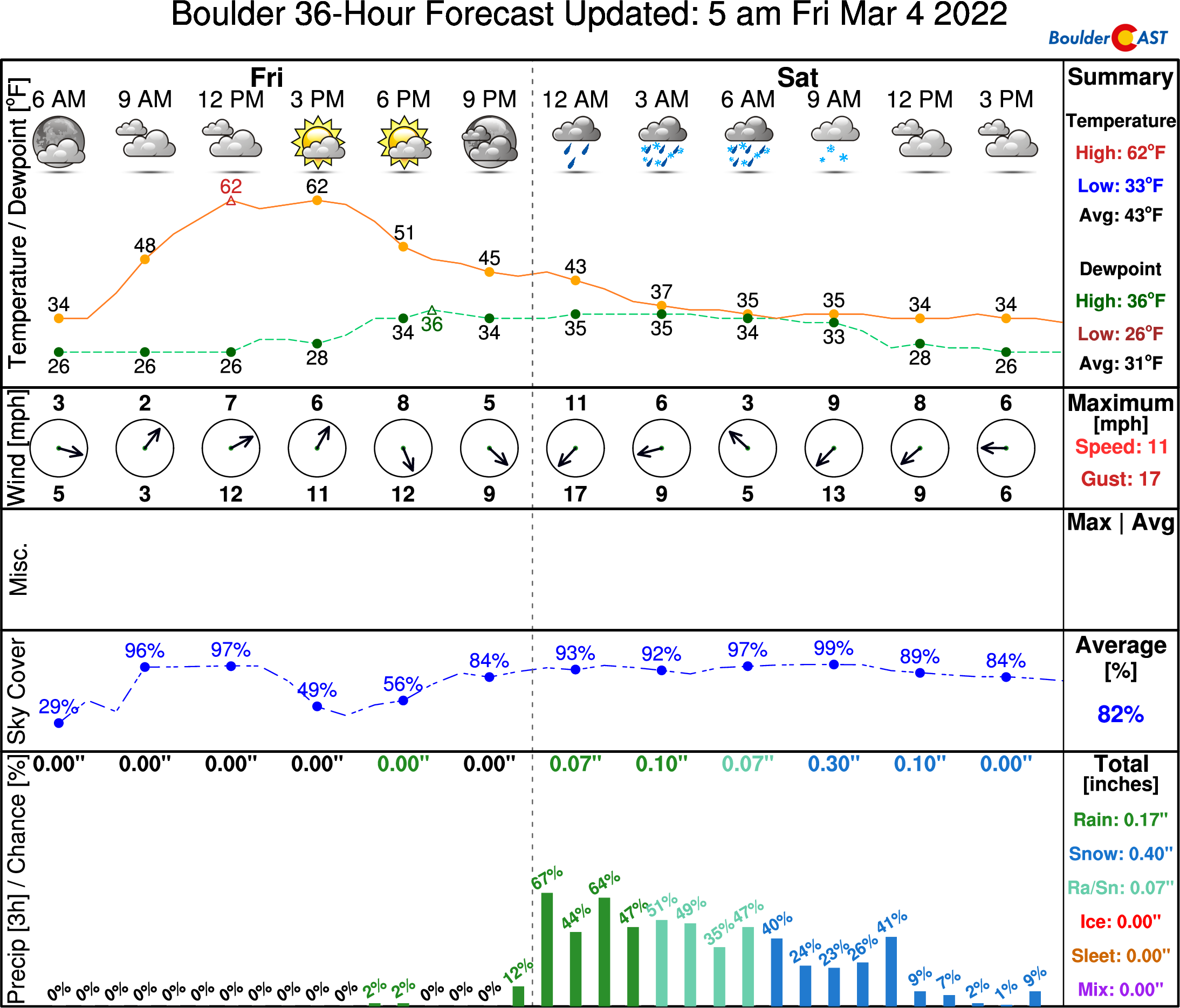
Our warm weather streak is still on-track to come to an end Friday evening after sunset, with isolated thundershowers followed by rain changing to wet snow overnight into early Saturday morning. In this brief update, we discuss the timing of everything, potential accumulations, and look ahead to Sunday as a colder system will enter the picture bringing more snow.
O
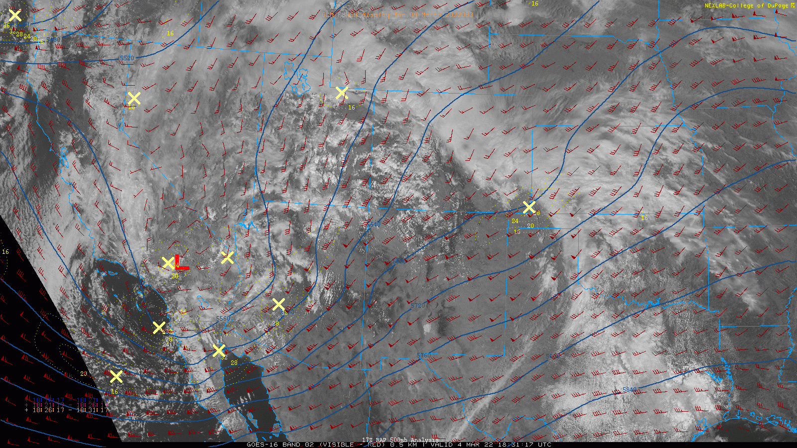
ur lengthy forecast discussion posted yesterday covered this weekend’s abrupt weather shift in great detail, though some things were still shrouded in uncertainty. Today we’re just offering a quick update as a spring storm bears down on Colorado. This afternoon’s GOES-East visible satellite animation shows the setup with the main disturbance located near Las Vegas. Out ahead of this, we’re in the warm and juicy sector with southwesterly flow evident. Upstream near the Four Corners, we’re seeing the first major convective outbreak since autumn with dozens of lightning strikes noted (flashing “+” symbols in the animation). The instability will progress our way this evening bringing the first chance of thunderstorms of 2022 to the Denver Metro area! We’re not expectation anything too widespread, but do keep an eye out for isolated storms this evening and don’t be surprised to see a few flashes or hear a few distant rumbles.
A cold front will blow through Friday evening bringing in chillier air from the north. Eventually temperatures will become cold enough for rain to change over to snow. That should happen before sunrise in most areas.
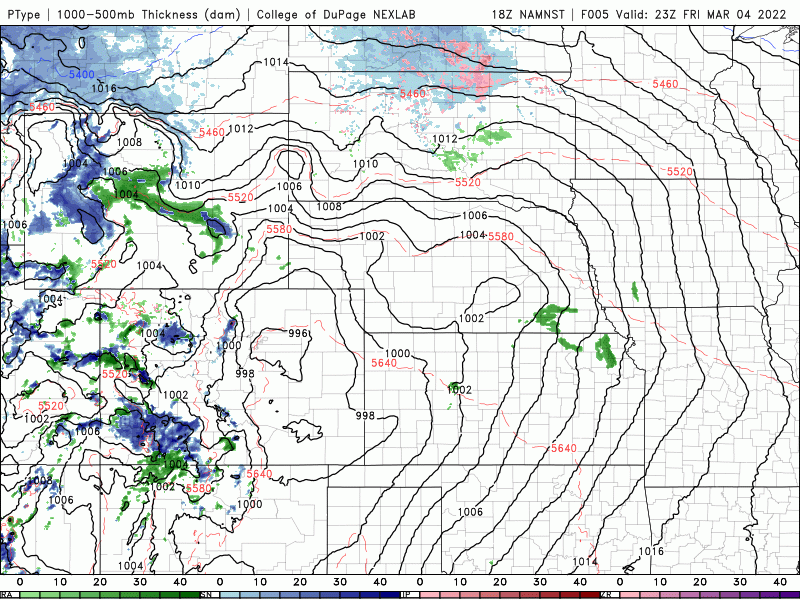
The main challenge with this forecast all along surrounded the potential for heavier precipitation to wrap into the Front Range as surface low pressure intensifies and moves through eastern Colorado. The simulated radar forecast below takes us from this afternoon into Saturday evening. Note the large snow band that develops over north-central Colorado early Saturday.
Despite the favorable dynamics and instability with this system, its track is not great for the immediate Denver Metro area with the main rain/snow band likely to pass to our north. Still, there is a good chance for some brief snow early Saturday from Boulder northward to the Wyoming border and eastward to Nebraska, especially those areas that see the heavier precipitation rates. Evaporative and dynamic cooling in these heavier cells will help speed up the change-over process. Despite this, any snow that occurs will be the wet and slushy variety — plus it will be falling onto a ground warmed by five straight days of near 70-degree weather this past week. Thus, don’t expect too much accumulation — most of what sticks will be on the grass and patio furniture.
Our snowfall forecast map for the first round of snow this weekend is shown below. This covers all snow falling Friday night through Saturday afternoon. The best chance of seeing a few slushy inches stick will be across the northern areas (i.e. Loveland, Greeley, and Fort Collins) and in the Foothills.
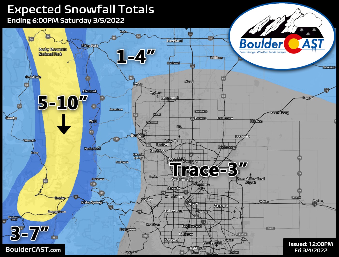
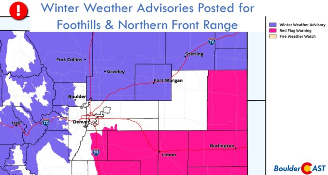
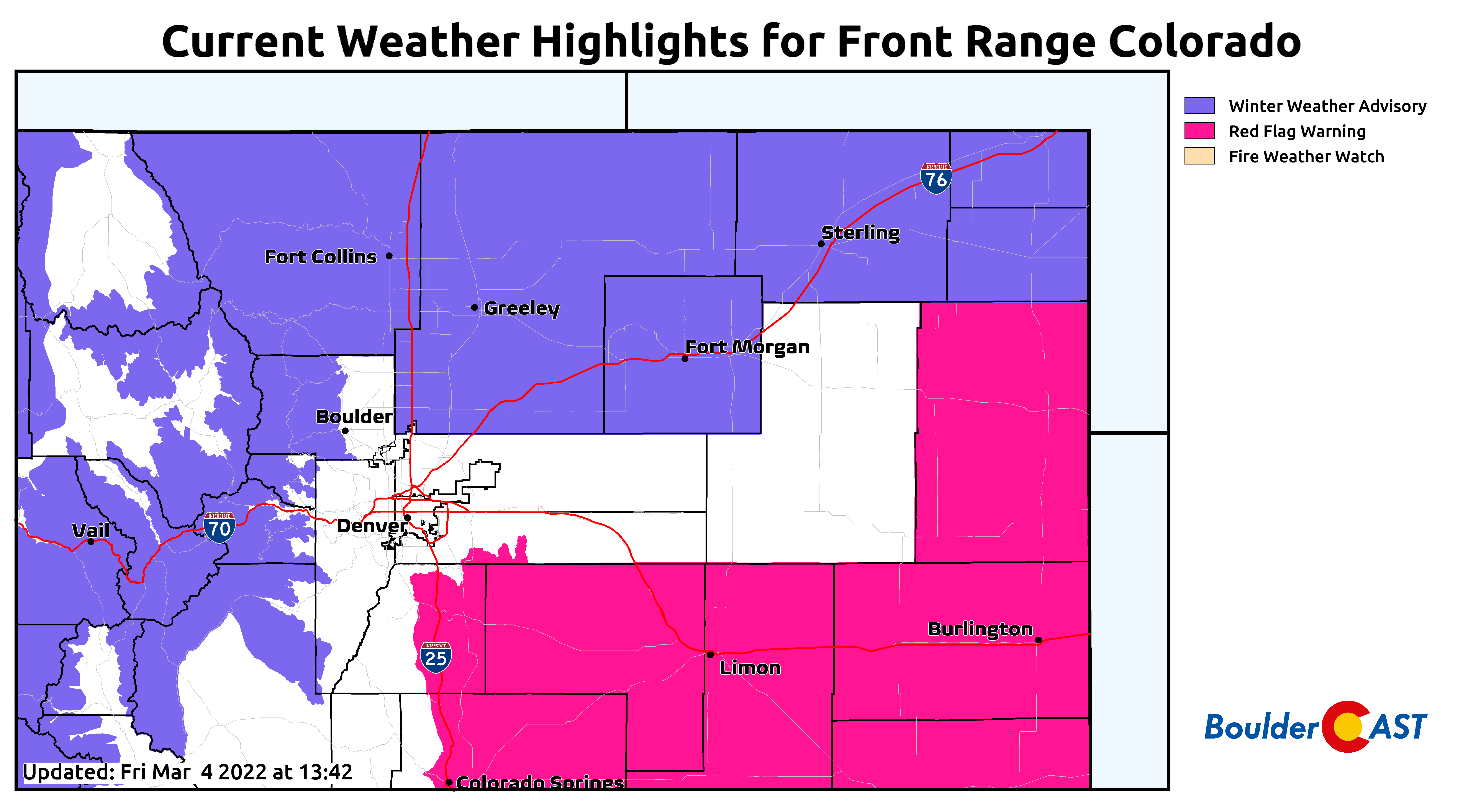
The National Weather Service has issued Winter Weather Advisories for these areas for this threat of heavy wet snow early Saturday. Remember, road surfaces are starting out very warm. It will take fairly significant snowfall rates to cause more than a meager disruption to travel. Roadways will be worst in the Foothills where temperatures have been and will be colder.
What’s left of the snow showers will quickly come to an end by midday Saturday with a lull in the action expected as downslope and large-scale subsidence take over for Saturday afternoon into the overnight. We could see a few convective snow showers bubble up over the Mountains Saturday afternoon and evening, but these won’t amount to much and should stay primarily over the higher terrain (Foothills included).
A secondary and more widespread round of snow will develop early Sunday into Sunday night for our area as yet another disturbance sets its sights on the Centennial State. That system will be colder with temperatures remaining entirely below freezing, more generous snow ratios, and real upslope. We’re currently thinking round #2 will be a 2-6″ type of event for our area favoring Boulder and the western suburbs. We’ll talk more about THAT chance of snow tomorrow. Get out there and take in the final few hours of warmth if you can!
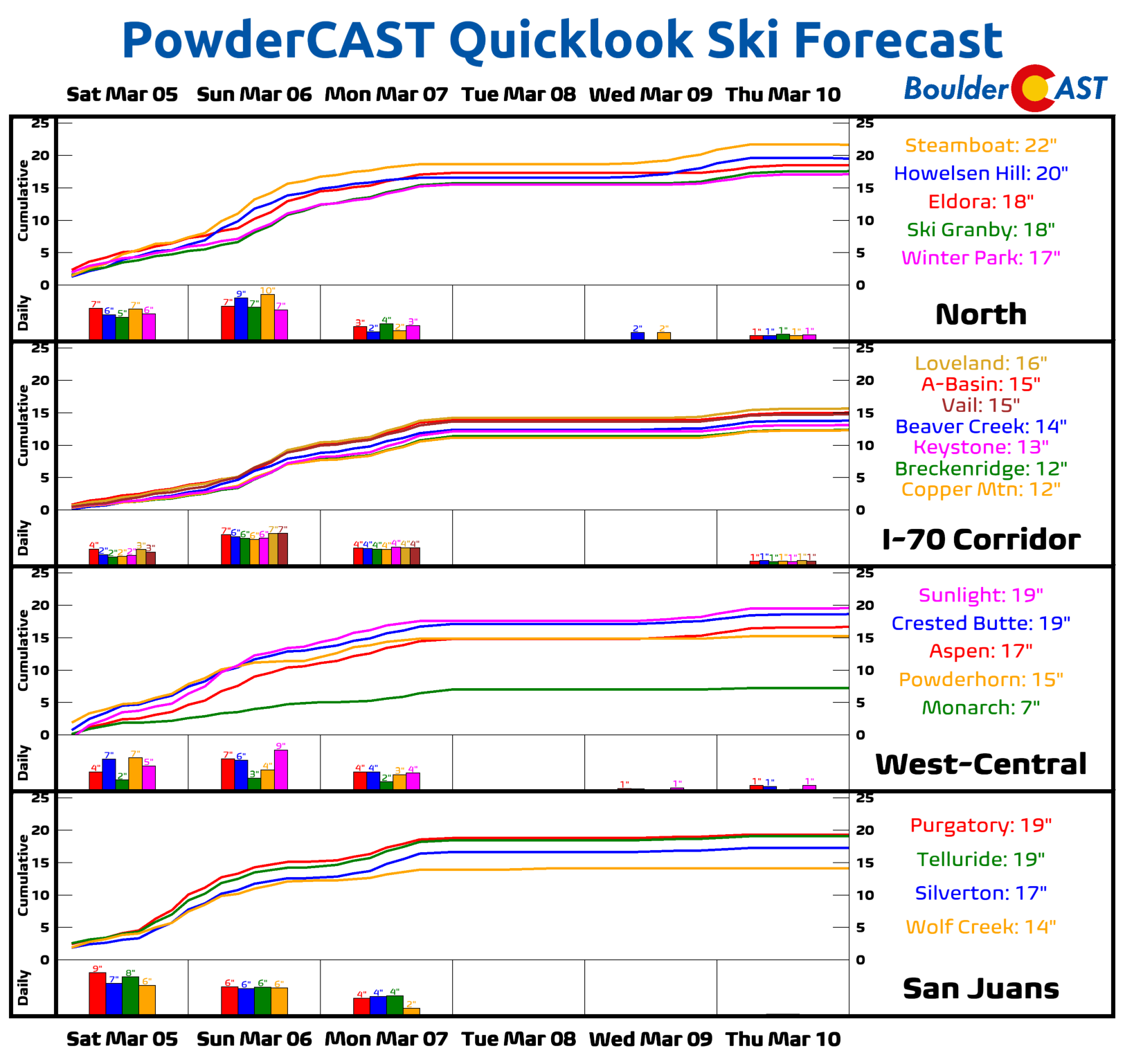
P.S. The Mountains will do excellent this weekend with just about every ski resort picking up to at least a foot of new snow. Get it!
Get BoulderCAST updates delivered to your inbox:
Help support our team of Front Range weather bloggers by joining BoulderCAST Premium. We talk Boulder and Denver weather every single day. Sign up now to get access to our daily forecast discussions each morning, complete six-day skiing and hiking forecasts powered by machine learning, first-class access to all our Colorado-centric high-resolution weather graphics, bonus storm updates and much more! Or not, we just appreciate your readership!

Enjoy our content? Give it a share!


You must be logged in to post a comment.