This week’s weather in the Front Range will feature a welcomed northwest flow pattern, one which will usher in cooler temperatures but unfortunately little in the way of rainfall as the monsoon remains at bay. Several disturbances will be tracking across northern Colorado but will have extremely limited moisture to work with resulting in most areas staying nearly bone-dry this week. While not good at all for the ongoing drought, this setup will allow for cool and beautiful conditions for the Fourth of July — just be mindful that fire danger is growing. Read on for all the details.
This week’s highlights include:
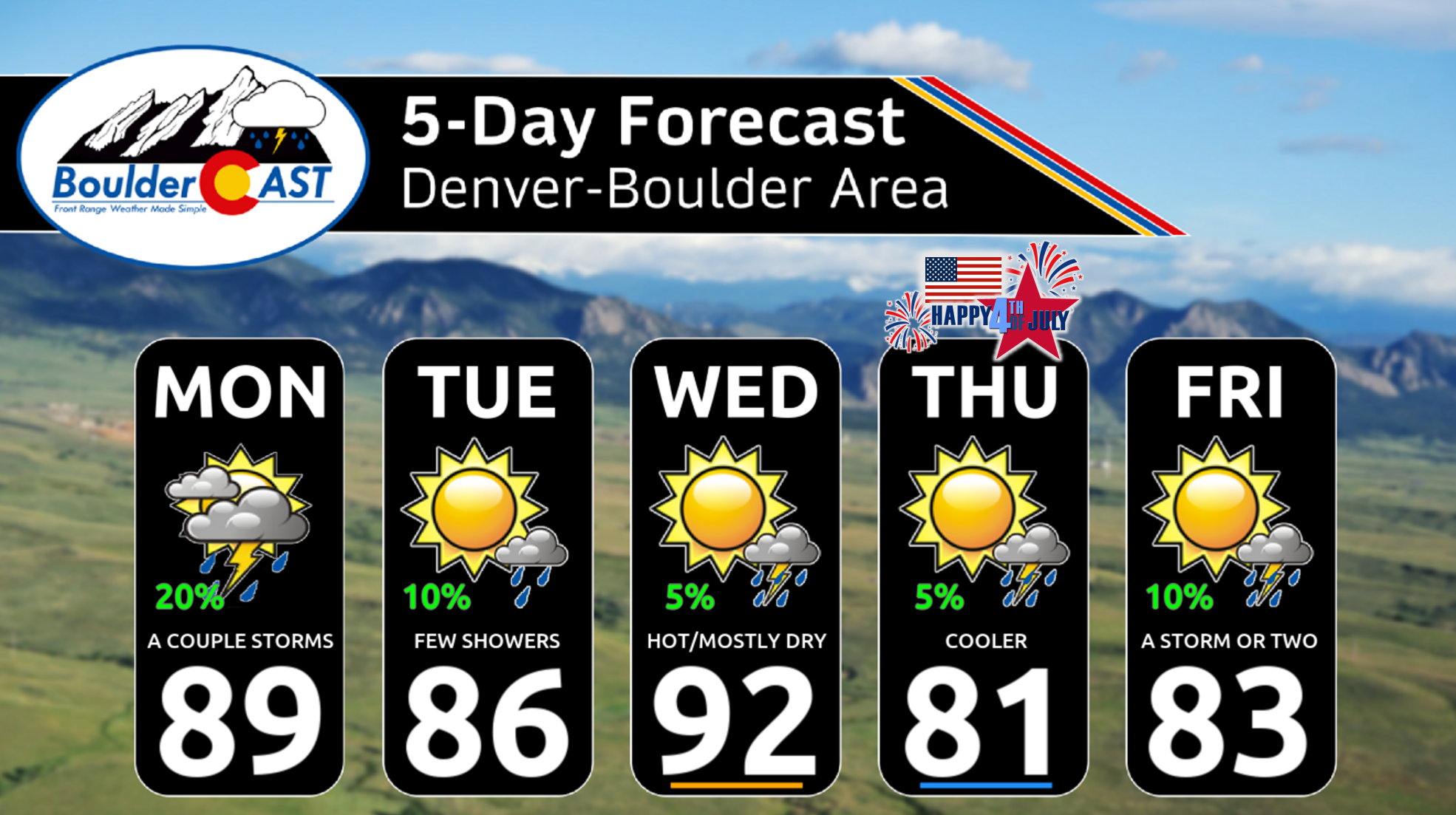
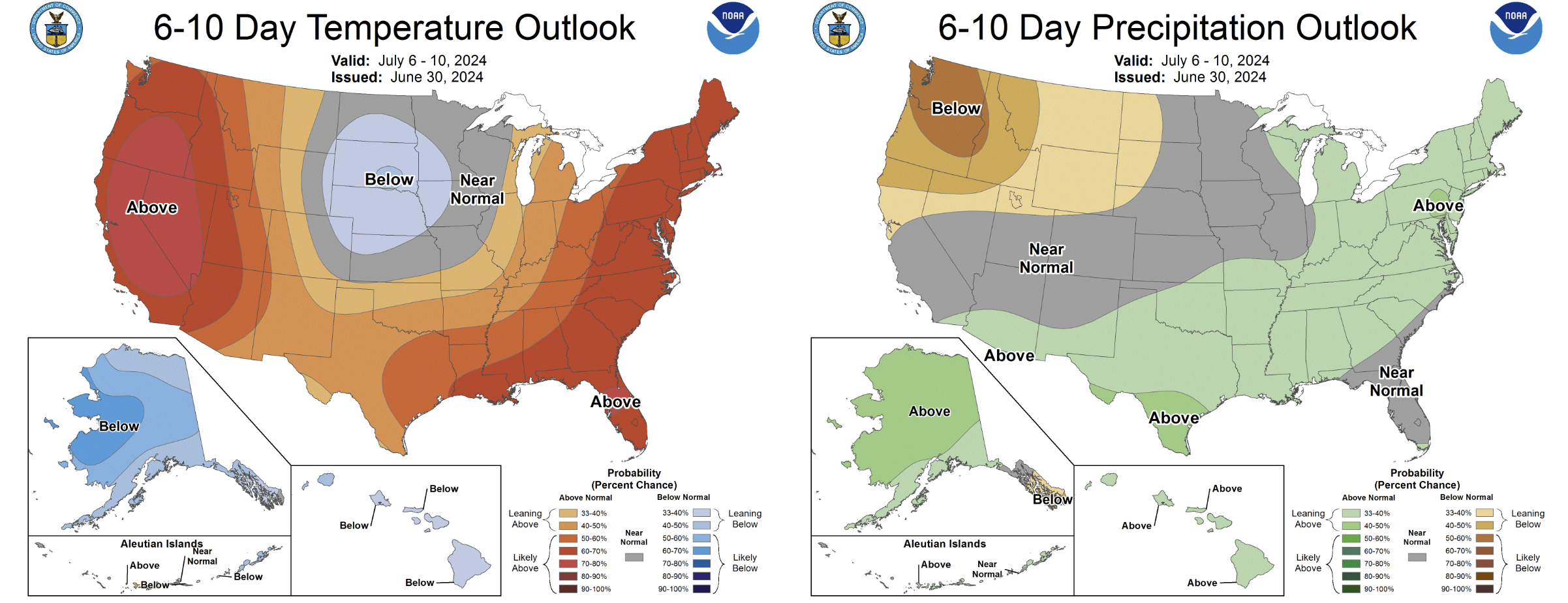
- Slightly Stormy Monday & Tuesday: Above normal moisture and a weak disturbance will see the best chance of rain for the week unfold Monday into Tuesday — but still only isolated to widely scattered coverage is expected
- Drier & Hot Wednesday: Midweek temperatures will push briefly back into the lower 90s as the atmosphere over Colorado dries out considerably — minimal to no chance of rain
- A Pleasant 4th of July: A decent cold front will move through Wednesday night making for comfortable weather for Independence Day — highs only in the lower 80s with close to zero chance for rain
- Weekend Outlook: Friday and the weekend will see temperatures creep back up towards 90 degrees with a slight risk of PM storms each day
DISCLAIMER: This weekly outlook forecast is created Monday morning and covers the entire upcoming week. Accuracy will decrease as the week progresses as this post is NOT updated. To receive daily updated forecasts from our team, among many other perks, subscribe to BoulderCAST Premium.

Go Premium, get all the perks.
Daily Forecast Updates
Get our daily forecast discussion every morning delivered to your inbox.
All Our Model Data
Access to all our Colorado-centric high-resolution weather model graphics. Seriously — every one!
Ski & Hiking Forecasts
6-day forecasts for all the Colorado ski resorts, plus more than 120 hiking trails, including every 14er.
Smoke Forecasts
Wildfire smoke concentration predictions up to 72 hours into the future.
Exclusive Content
Weekend outlooks every Thursday, bonus storm updates, historical data and much more!
No Advertisements
Enjoy ad-free viewing on the entire site.
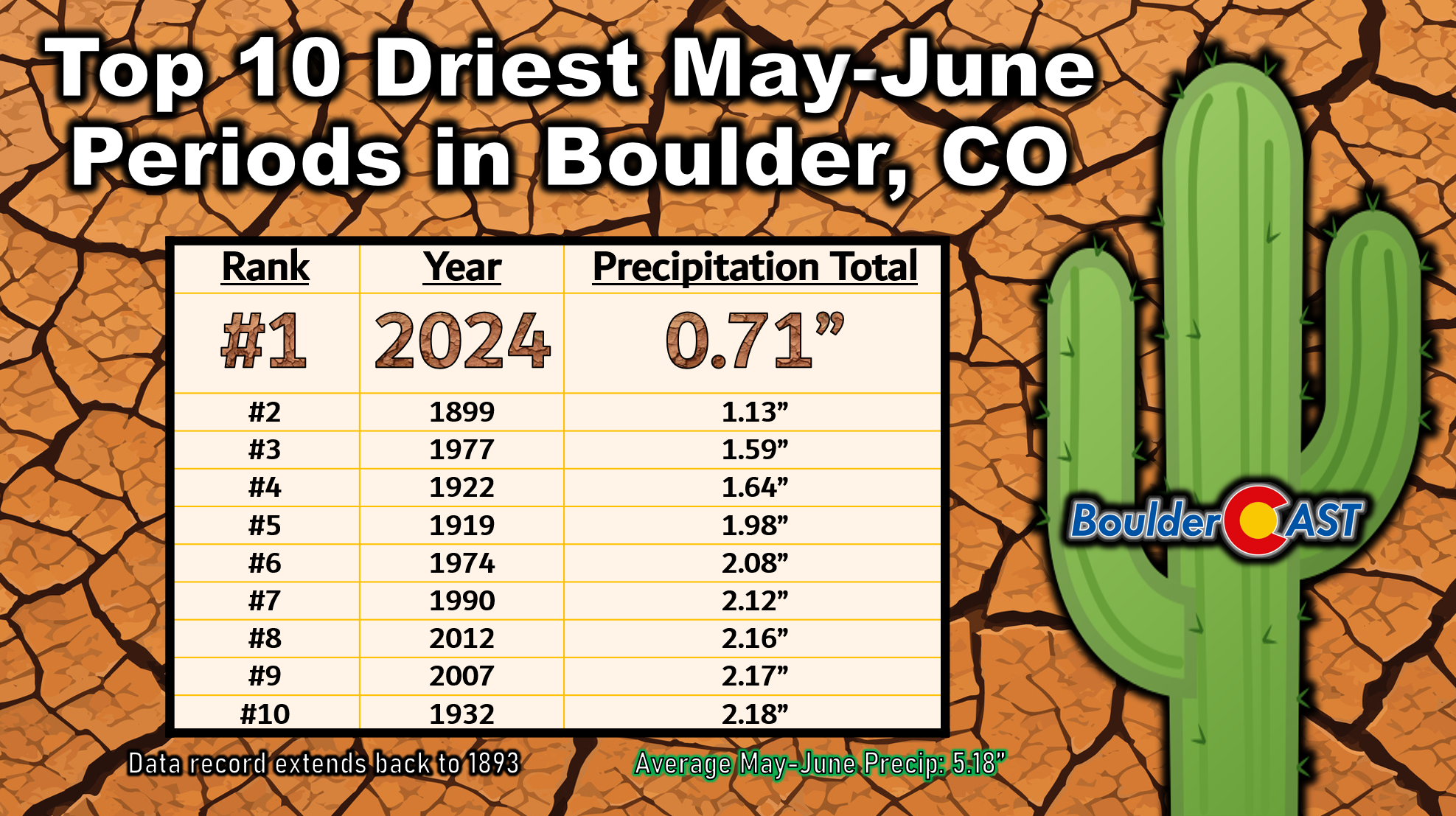
✅ All-time dry May and June
Well, we were not able to muster up much precipitation at all last week or over the weekend — not too different from the many weeks prior. Officially Boulder finished the month of June recording only 0.27″ of rainfall, our driest June is 100 years and the second driest all-time. This comes hot on the heels of the second driest May all-time. Combined, the May and June period this year was the driest ever in Boulder, and it wasn’t even close with only 0.71″ of rainfall in the last two full calendar months. Normally we would expect around 5.2″ of rain to fall during this period.
Looking ahead, this week’s forecast certainly doesn’t inspire confidence that we will buck this dry trend, but let’s get into it.
July begins cool but unfortunately dry as well
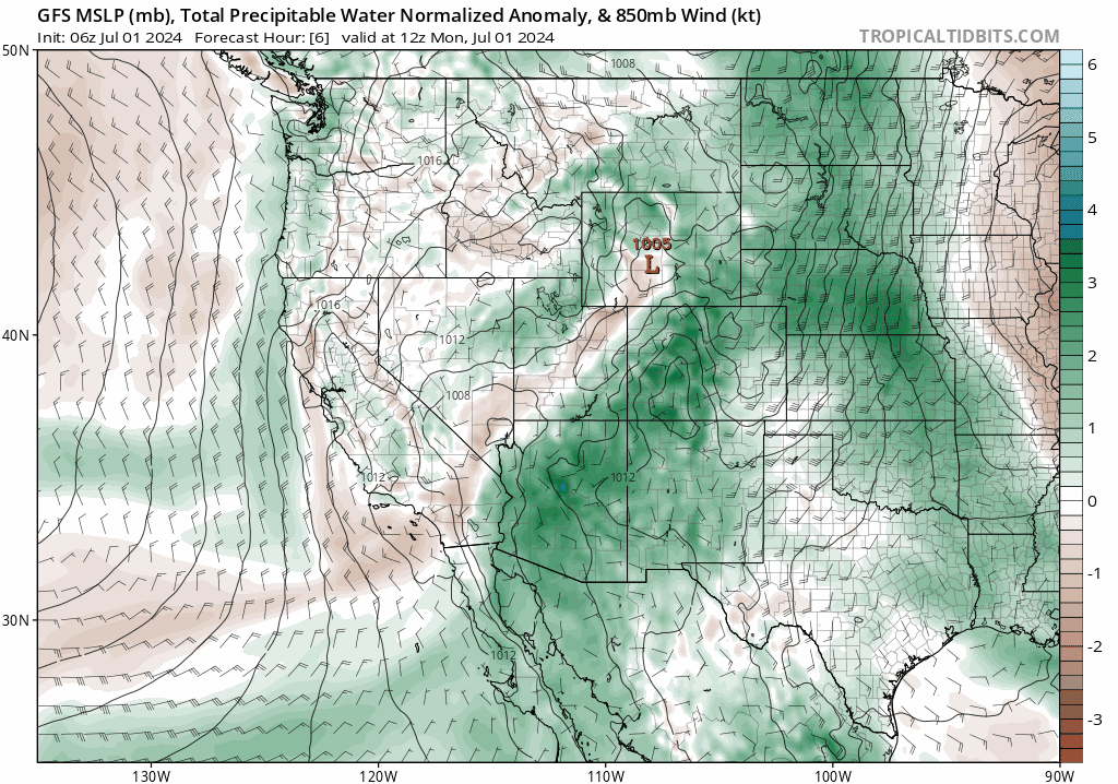
The good news is that the week ahead will feature a more active weather pattern for northern Colorado with cooler temperatures arriving behind a collection of cold fronts. The bad news is that despite this promising pattern, minimal rainfall is expected across the Denver Metro area this week. The GFS 500mb vorticity forecast animation below runs from Monday morning through Friday night. We’re happy to report that there isn’t a huge ridge of high pressure dominating our weather like we had most of June. Instead, this week will feature cooler northwest flow with a handful of shortwave troughs and disturbances clipping northern Colorado — almost one shortwave every day through Friday.
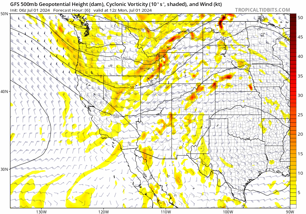
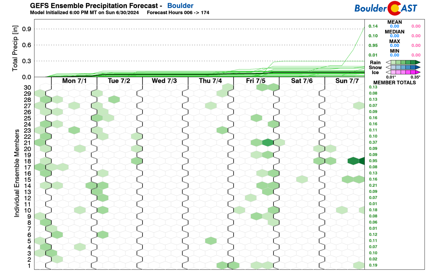
The main issue is that these disturbances will move through with only very limited access to moisture. While Monday and Tuesday will have slightly above normal precipitable water in the Front Range, Wednesday and beyond will unleash an exceptionally dry airmas over Colorado with only isolated storm coverage at best, mainly across far eastern and southern Colorado.
The result will be a tiny chance of showers or storms each day in the extended, but with a net result of all the week’s thunderstorm activity leaving most locations totally dry or darn close to it. The only day this week completely devoid of any storms in the ensembles right now is Wednesday, but even the days with storms will have somewhat limited or even worse, extremely limited, moisture with little rainfall actually reaching the ground in the Metro area.
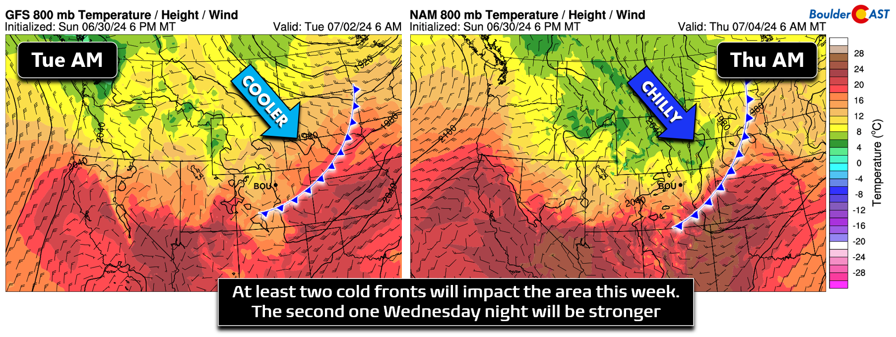
For temperatures, they will be up and down this week owing to the constant influx of disturbances in the northwest flow. Accompanying things will be a series of cold fronts dropping in from the north. At minimum we’re expecting a weak front to move through Monday night. A secondary and stronger cold front is planned for Wednesday night which will cool things off further late-week. There may also be a third front Thursday night providing a reinforcing shot of cooler air, but that remains more uncertain for now.
As mentioned, the extended forecast will offer cooler but fluctuating temperatures with a sliver of a chance for rain each day. The weather for the Fourth of July on Thursday looks excellent for outdoor activities all day long, including evening firework displays. Highs on Thursday will be comfortable in the lower 80s. While winds will be on the lower side, Thursday could see Red Flag Warnings posted for some of the Front Range, if nothing else out of abundance of caution. Be aware that active Red Flag Warnings would likely nix firework displays in many cities.
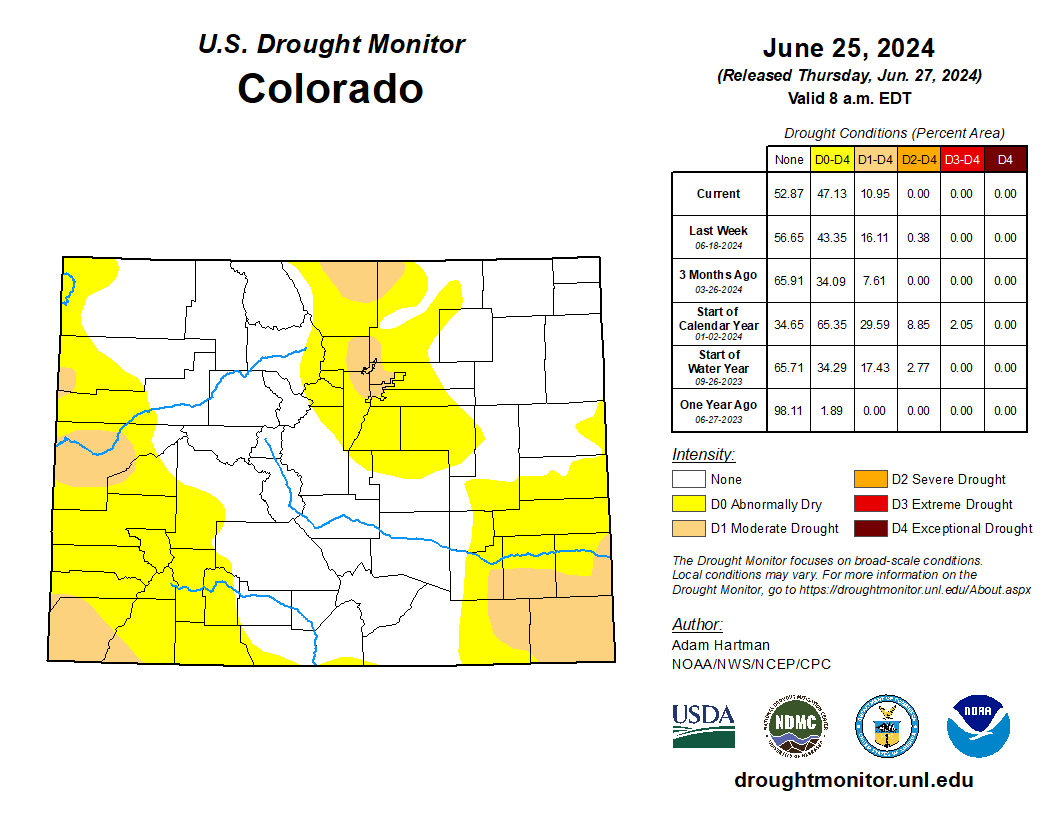
While there are currently no fire bans in place across Boulder County or adjacent counties, some of our area is now in Moderate Drought. Thus, fire bans could possibly be enacted in the coming days so keep an eye out for potential changes in planned firework shows or fire(work) bans.
The upcoming weekend will see more of the same weather unfold across the Denver Metro area, though we will start to heat back up temporarily. Highs this weekend will return towards 90 degrees with a slight risk of late-day storms Saturday and Sunday. The very same northwest flow pattern from this week looks to stick around into next week with additional cold fronts providing cooler conditions at times.
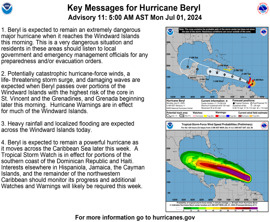
Finally, we wanted to show you Category 4 Hurricane Beryl, which is currently barreling towards the Lesser Antilles islands in the Caribbean (pun intended). In super rare fashion for June, Beryl rapidly intensified over the last 36 hours beyond even the most bullish of hurricane model projections, now becoming a significant threat to life. As of writing Monday morning, the well-formed outer eyewall is just reaching the islands and is likely to cause significant devastation today as it has 150 MPH sustained winds around its eye.
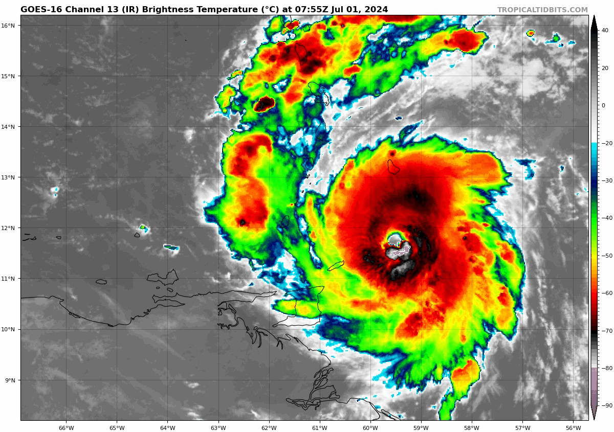
Beryl is anticipated to weaken but remain a formidable hurricane this week before making another landfall in the Yucatan Peninsula Thursday night with perhaps a third landfall in the Gulf of Mexico late in the upcoming weekend.
That’s all for now. Be sure to check back Tuesday morning as we will post our Summer 2024 Colorado Monsoon Outlook. Spoiler: It’s not looking good. Enjoy the quiet and cooler week in Colorado weather, and of course, happy Fourth of July from the BoulderCAST team!
![]()
Get BoulderCAST updates delivered to your inbox:
Forecast Specifics:
Monday: Partly to mostly cloudy with a slight chance of morning showers. Then warm with isolated late-day thunderstorms. Highs reach the upper 80s on the Plains with middle 70s in the Foothills.
Tuesday: Mostly sunny and slightly cooler with a slight chance of morning showers and then later, late-day thunderstorms. Temperatures will top out in the middle 80s on the Plains with lower 70s in the Foothills.
Wednesday: Hot and mostly dry with one or two isolated thunderstorms, mainly east of Denver where a few storms may turn severe. High temperatures soar back into the lower 90s on the Plains with near 80 in the Foothills.
Thursday (Independence Day): Lots of sunshine with just a slight chance of a late-day thunderstorm. We’re not expecting any issues for outdoor activities, including mostly quiet conditions for the evening fireworks. Highs will be cooler in the lower 80s behind a cold front on the Plains, with lower 70s in the Foothills.
Friday: Mostly sunny and a tad warmer with isolated late-day thunderstorms. Highs in the low to middle 80s on the Plains with lower 70s in the Foothills.
Weekend: More of the same weather is expected but temperatures will creep back up towards 90 degrees both Saturday and Sunday. Both days will also feature isolated PM thunderstorms.
DISCLAIMER: This weekly outlook forecast is created Monday morning and covers the entire upcoming week. Accuracy will decrease as the week progresses as this post is NOT updated. To receive daily updated forecasts from our team, among many other perks, subscribe to BoulderCAST Premium.
Go Premium, get all the perks.
Daily Forecast Updates
Get our daily forecast discussion every morning delivered to your inbox.
All Our Model Data
Access to all our Colorado-centric high-resolution weather model graphics. Seriously — every one!
Ski & Hiking Forecasts
6-day forecasts for all the Colorado ski resorts, plus more than 120 hiking trails, including every 14er.
Smoke Forecasts
Wildfire smoke concentration predictions up to 72 hours into the future.
Exclusive Content
Weekend outlooks every Thursday, bonus storm updates, historical data and much more!
No Advertisements
Enjoy ad-free viewing on the entire site.
Enjoy our content? Give it a share!


You must be logged in to post a comment.