Following a weekend of quiet weather, the week ahead will continue that trend of near normal temperatures under downslope flow — at least for a few more days. The Mountains will see two waves of snowfall Monday through Wednesday with more than a foot expected in some ranges and ski resorts. As for the Plains, a midweek system will produce a period of light snowfall as well, but only with low-end accumulations expected alongside cooler temperatures.
This week’s highlights include:
- Temperatures will largely hover near to seasonal normals, but warm/cooler periods at times
- Warmest days are expected to be Monday, Tuesday, and Friday in the upper 40s to middle 50s; coolest days Wednesday and Thursday in the upper 30s to middle 40s
- A strong atmospheric river across the West Coast will move onshore Tue/Wed bringing heavy mountain snowfall —- gusty winds in and near the Foothills
- The system passes through the Plains Wednesday with light snow for the Denver Metro and notably cooler temperatures
- An anomalous ridge is set to develop late in the week and early part of the weekend with warmer weather returning

DISCLAIMER: This weekly outlook forecast is created Monday morning and covers the entire upcoming week. Accuracy will decrease as the week progresses as this post is NOT updated. To receive daily updated forecasts from our team, among many other perks, subscribe to BoulderCAST Premium.

Near normal temperatures start the week
Quiet weather, at least for the Plains, will start our week with seasonal temperatures in the 40s to some lower 50s on Monday and Tuesday. A look at the GEFS temperature trend this week shows these near to slightly above normal highs prior to Wednesday, then a cool down Wednesday and Thursday with a midweek storm system. The end of the will be similar to the start, though warmer weather is expected with a ridge set to develop. It will largely be a dry week for us on the Plains but there is one small precipitation chance midweek, which we’ll discuss shortly.
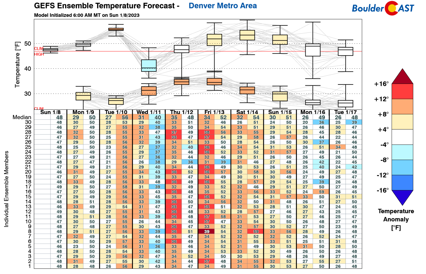
Downslope flow will continue on Monday, favoring some upper 40s to lower 50s once again under partly cloudy skies. However, that pesky snow cover still lingers in several locations of the Denver/Boulder area. For this reason, some areas near and east of Longmont will likely be cooler in the upper 30s/lower 40s.

A strong atmospheric river will once again pummel California today and tonight. This has been the case much of the past weekend, bringing heavy mountain snow to the Sierras and a deluge of rainfall/flooding across the lower elevations. The atmospheric river will reach Utah later today and the western mountains of Colorado tonight into early Tuesday. That will facilitate the first of two waves of snow across the High Country this week.

With that atmospheric river sending anomalous moisture to the Rockies Tuesday, clouds will be on the increase on the Plains. The continued downslope flow will persist, however, with adiabatic warming again playing out. However, the high clouds and wave action could prevent us from getting well into the 50s. For this reason, upper 40s to lower 50s are again forecast, but note that some areas in more sunshine could reach the middle to even upper 50s. Some gusty winds up to 30 mph in the Foothills and western Boulder Tuesday are possible, but it is unclear how much of these higher winds aloft will mix down to the surface.
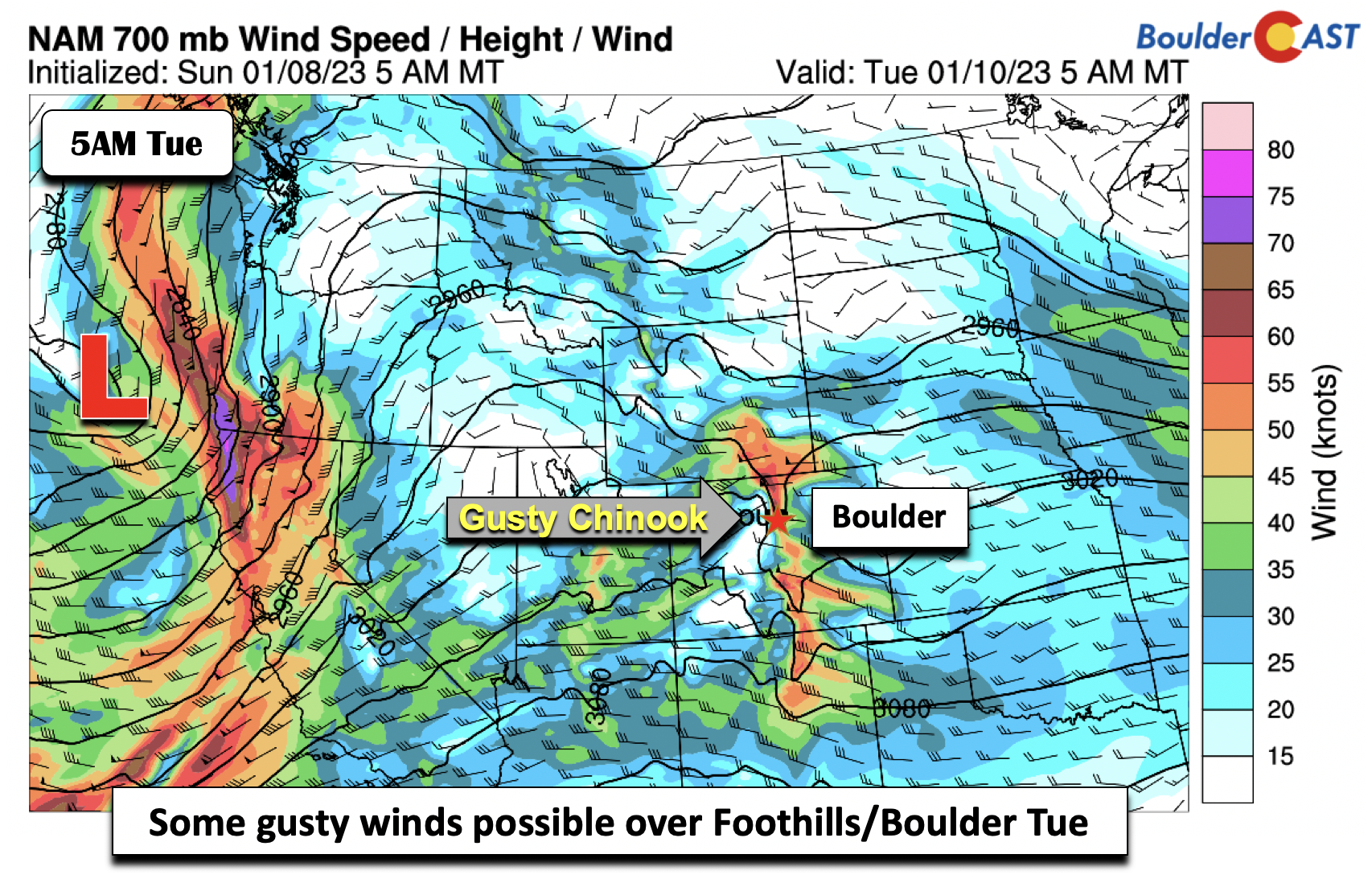
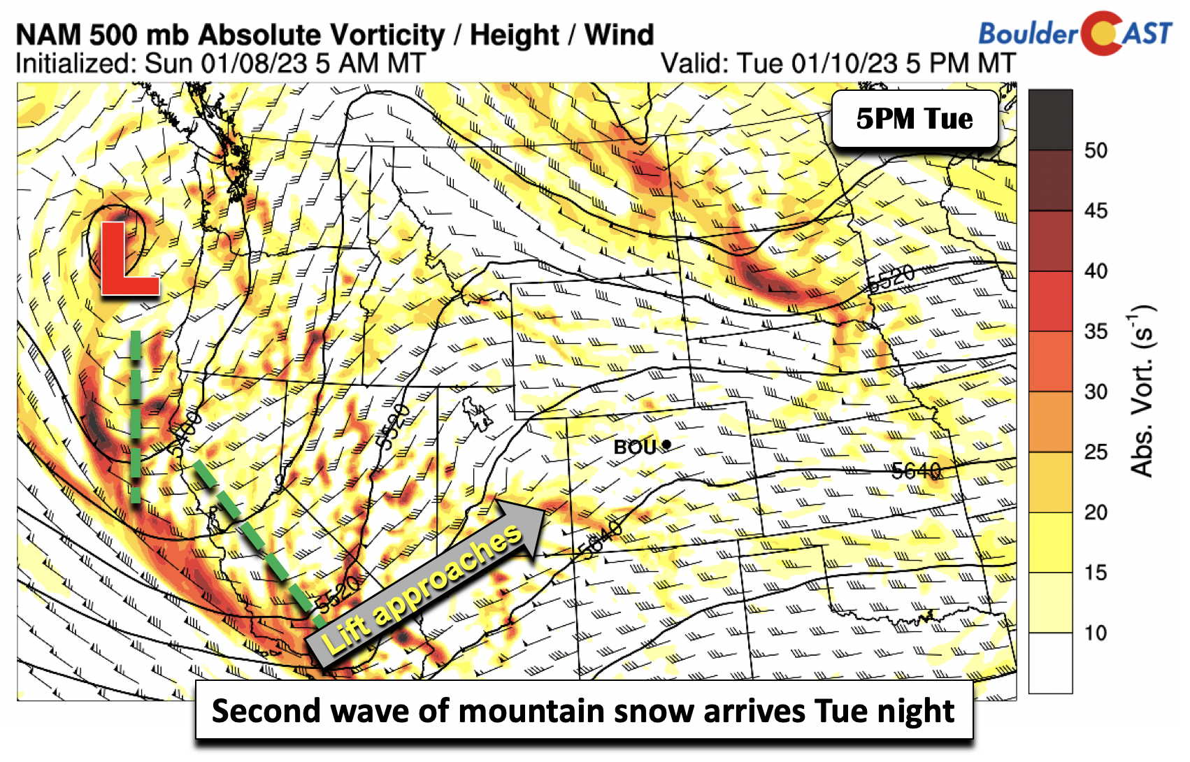
The second wave of the system comes in late Tuesday night into Wednesday, as the trough out west moves onshore over southern California and Nevada. Lift starts to approach by early Tuesday evening in far southwest Colorado.
Midweek system largely spares the Front Range
By early Wednesday, the storm system is progged to reach southern Utah, with deep lift penetrating the southwest part of Colorado.
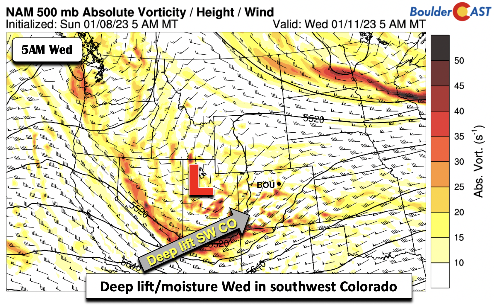
This second wave of snowfall over the higher terrain will be stronger than the first, owing in large part to deep upslope in the low to mid-levels. Note the map below, which shows 20-30 mph flow at 10,000 feet across the San Juans and Sawatch Range. This coupled with anomalous moisture will make for excellent conditions for heavy snow in the mountains. Some avalanche warnings could be issued later this week if amounts come to fruition.

Nearly all guidance shows that the system by late Wednesday takes a southeast track into Texas and Oklahoma, shared by the ECMWF/GFS/CMC and GEFS. This track would largely favor downslope flow on the Plains and only lighter snow chances. The one outlier is the NAM, which wraps up the system across east-northeast Colorado, and brings more moisture northwestward into the Denver Metro. But this is not shared by the other models. For this reason, the passage of the system should largely spare the Denver area.

Adding to the heavy snow in the mountains for Wednesday will be some instability, which should favor brief heavy snowfall rates of 1-2 inches per hour.

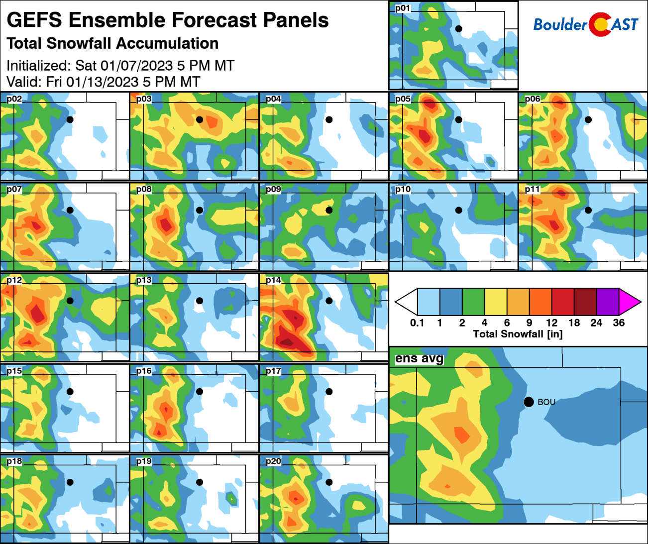
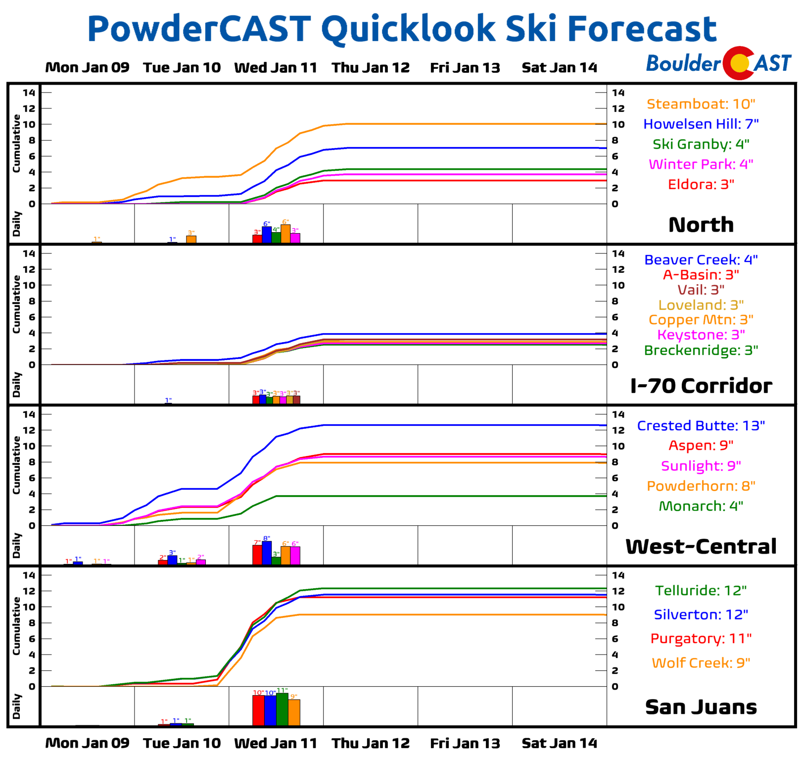
The ECMWF model shows total snow accumulations by early Thursday of less than 1″ for the Denver Metro area. The GFS/CMC are similar. Note the high snowfall totals (several places over a foot) along the western/southwest mountains. Skiers should be happy for the coming weekend with fresh powder in place.

A look at snowfall probabilities from the GEFS shows only a 30-40% chance of greater than 1 inch. The higher probabilities are obviously over the Mountains.
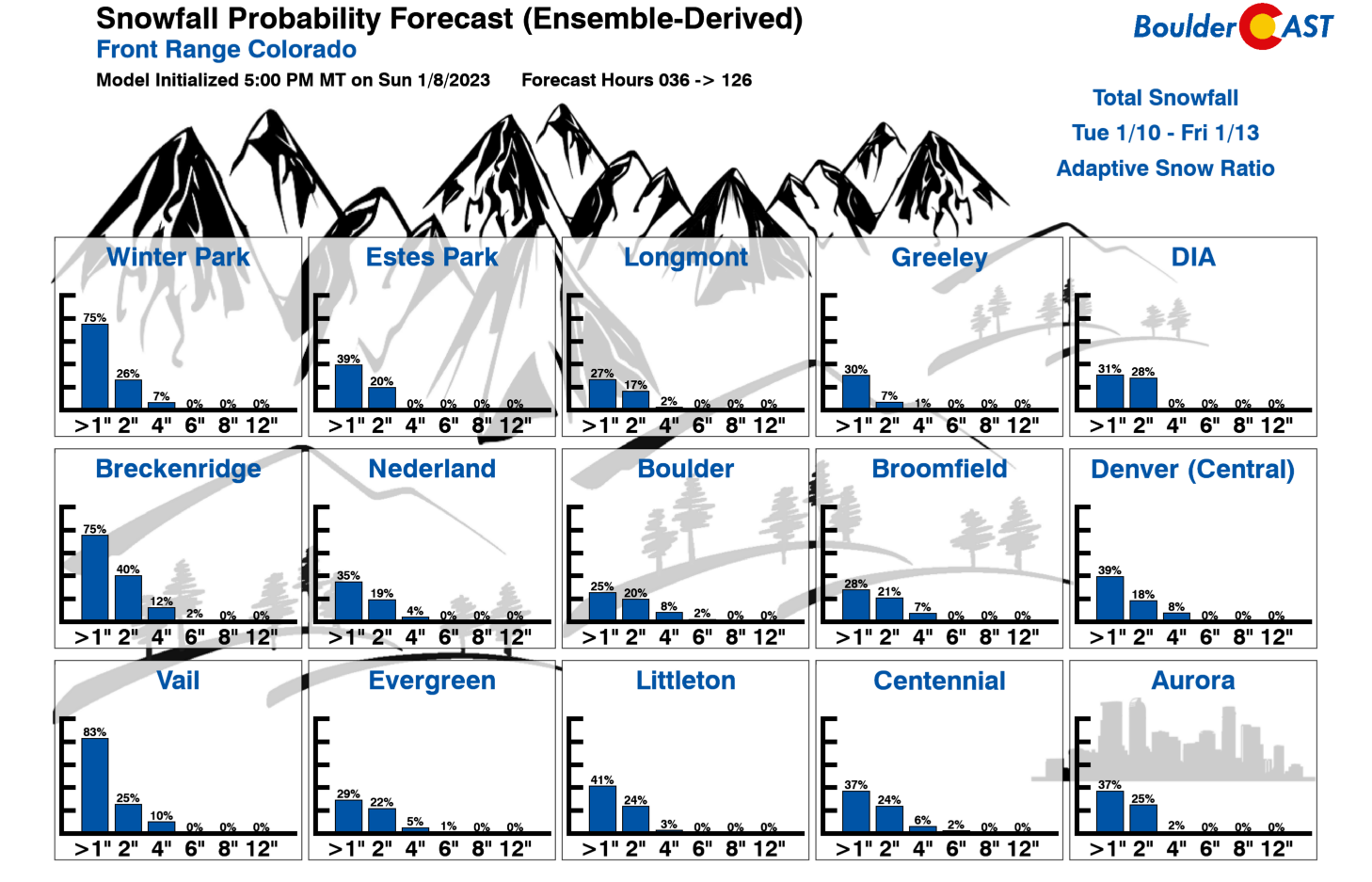
The GEFS total snowfall maps (individual members and ensemble mean) also show the low-end chance for snow in Boulder and Denver. Only a few solutions (members 8-10) show snow on the Plains. The ensemble mean total ranges from a trace to 1″, with a slight chance of 1-2″ east of Denver with the wrap-around moisture. Unless the track of the system changes drastically more toward a NAM solution, we should largely squeak by mostly unscathed this week.
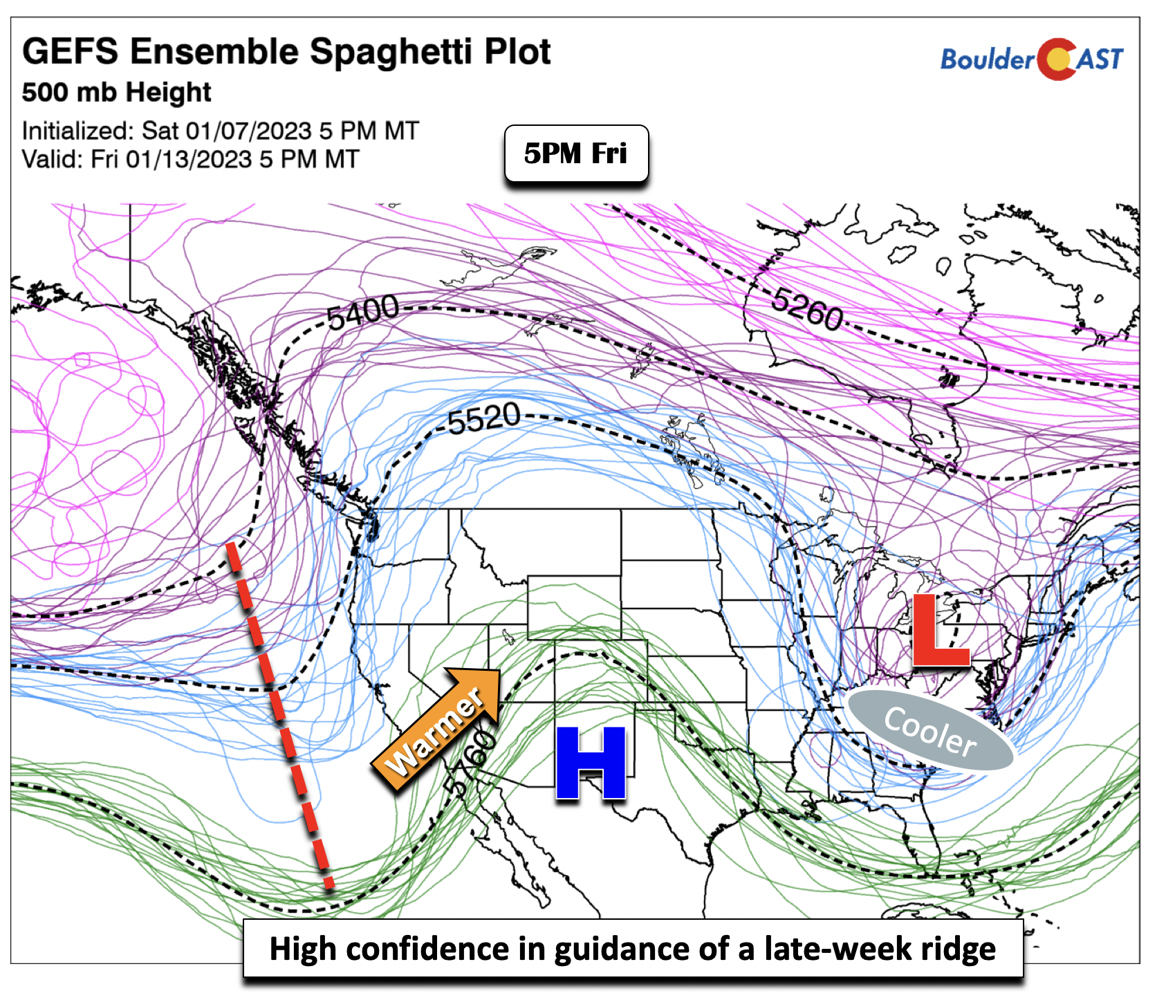
Guidance favors anomalous ridge by week’s end
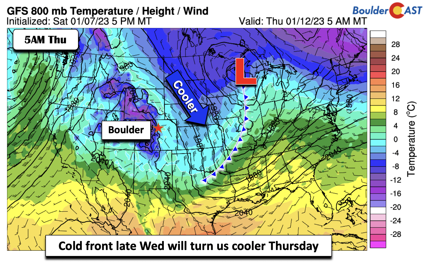
Regardless of how the midweek wintry system evolves, it will be cooler Wednesday and Thursday, with upslope and cooler air midweek and a cold frontal passage. The surface component of the storm will develop as a surface low over Wisconsin by midday Thursday, with a ridge over Utah. We’ll be in a cooler airmass Wednesday and Thursday with temps in the low to middle 40s.
Although models seems to be too fast in building ridges in during the winter season, the majority of ensemble guidance shows an anomalous ridge setting up Friday into the beginning of the weekend. The GEFS ensemble spaghetti plot shows that nearly all members have a ridge axis extending from Colorado into Mexico by late Friday. This should help get our highs back to the 50s, but if any snow cover continues to linger (and if we get any from Wednesday), 40s may be more favored. There are signals that the late-weekend period and early next week will turn more active as the storm track develops again from the southwest with the subtropical jet once again become a player.
Enjoy the week!
Forecast Specifics:
Monday: Partly cloudy and seasonal with upper 40s to lower 50s on the Plains and upper 30s to lower 40s in the Foothills.
Tuesday: Increasing clouds with some gusty winds possible on the Plains and Foothills of 20 to 40 MPH. Highs in the upper 40s to lower 50s for the Plains and upper 30s to around 40 in the Foothills. Some light snow may develop in the Foothills late Tuesday night.
Wednesday: Mostly cloudy with a chance of snow on the Plains. Highs in the lower 40s on the Plains and middle 30s in the Foothills. Light accumulations are possible in the Foothills, with a trace to 2″ on the Plains.
Thursday: Partly cloudy and cool with low to middle 40s on the Plains and upper 30s in the Foothills.
Friday: Warmer with partly to mostly sunny skies. Highs upper 40s to lower 50s for the Plains and upper 30s to lower 40s in the Foothills.
High Country: Two rounds of snowfall will be favored across the mountains this week. The first round will develop late Monday night and into early Tuesday evening. The second bout will be stronger, arriving from late Tuesday night into Wednesday night. Total snowfall accumulations are expected to be around a foot, with up to 2 feet in higher mountain peaks. An avalanche warning may be needed later this week. Drier weather is favored Thursday and Friday.
Help support our team of Front Range weather forecasters by joining BoulderCAST Premium. We talk Boulder and Denver weather every single day. Sign up now to get access to our daily forecast discussion email each morning, complete six-day skiing and hiking forecasts powered by machine learning, first-class access to all our Colorado-centric high-resolution weather graphics, bonus storm updates and much more! Or not, we just appreciate your readership!
Spread the word, share the BoulderCAST forecast!


You must be logged in to post a comment.