
Happy New Year! We’re starting off 2023 unsettled with more snow! There’s no holiday rest for us meteorologists here in the Front Range as yet another southern-track winter storm is knocking on the door. This one will unfold in two phases — the first being a period of freezing drizzle/snow showers Sunday night with a second phase of snow (some heavy) developing during the day Monday. In this forecast update we talk about timing, potential snowfall totals and the extended outlook for the rest fo the week.
Update (5PM 1/1/2023): Lowered snowfall amounts and updated snowfall map based on latest guidance.
New year, more snow!
Just like the booming storm a few days ago, this one will be supplied with juice directly by the subtropical jet stream (i.e. the Pineapple Express). This type of southern-track storm is more common to see during an El Niño winter as opposed to the ongoing La Niña setup we’ve had for the last three years. GOES-East water vapor shows a surge of lofted moisture flowing into Colorado from the southwest out ahead of the main low pressure which is located back across parts of California as of Sunday morning. This moisture plume is producing moderate to heavy snowfall across the Mountains on this New Year’s Day. Definitely expect winter driving conditions if you are heading up to the High Country on Sunday (and Monday/Tuesday as well).

Over the next 24 to 48 hours, this mid-level low pressure will move basically due east and navigate its way into eastern Colorado by Monday evening. The animation below from the GFS model shows the evolution of the low and its forecast track into our neck of the woods.

Over the last several days, the global weather models have been advertising this as mainly a Wyoming/Nebraska winter storm — a consequence of that track west to east directly over the Denver area. We’ve been cautiously optimistic that it would take a path slightly further south, one that would be snowier for our area, but that doesn’t really appear to be the case. Most models are still zeroing in on a position of the mid-level storm across northeast Colorado by Monday evening. Unfortunately for our sanity, it’s now only the best-in-class European model which is predicting a track slightly further south across southeast Colorado. It’s an outlier right now and has been the last few days, but even the European ensembles are still focusing south. Despite this, we are cautiously leaning our forecast more in-line with the other models which have better agreement amongst one another.

After the booming storm last week, the general public consensus is that most of us meteorologists have no idea what we are talking about and every snowstorm moving forward will be an explosion of snow for our area. Sadly the latter is not the case — though that would make life more interesting for us. This system will be a completely different beast than the last one. It has less moisture to work with and just plain isn’t as dynamic. Snow will be slow to develop and will mostly be falling during the daylight hours on Monday. There will even be a period Sunday night where light freezing drizzle will be the dominant precipitation type under shallow upslope flow. Plus, a ol’ big dry slot could very well spoil most of the party on Monday for us.
There will be two waves of precipitation to watch out for. The first comes Sunday night mainly driven by weak moist upslope from the southeast direction.

This shallow push of upslope will be relatively warm and largely decoupled from the mid-levels and thus it will be a mixed bag of precipitation Sunday night into early Monday. We anticipate pockets of snow showers, freezing drizzle and snowballs mixed together with temperatures below the freezing mark through early Monday morning. The first wave should not lead to much accumulation for us, likely a dusting to 1″ of snow in most areas by sunrise Monday. The bigger concern will be the glaze of ice. There could be traction issues for the Monday morning commute especially on bridges and overpasses, but the fact that it is a federal holiday should limit the impact.
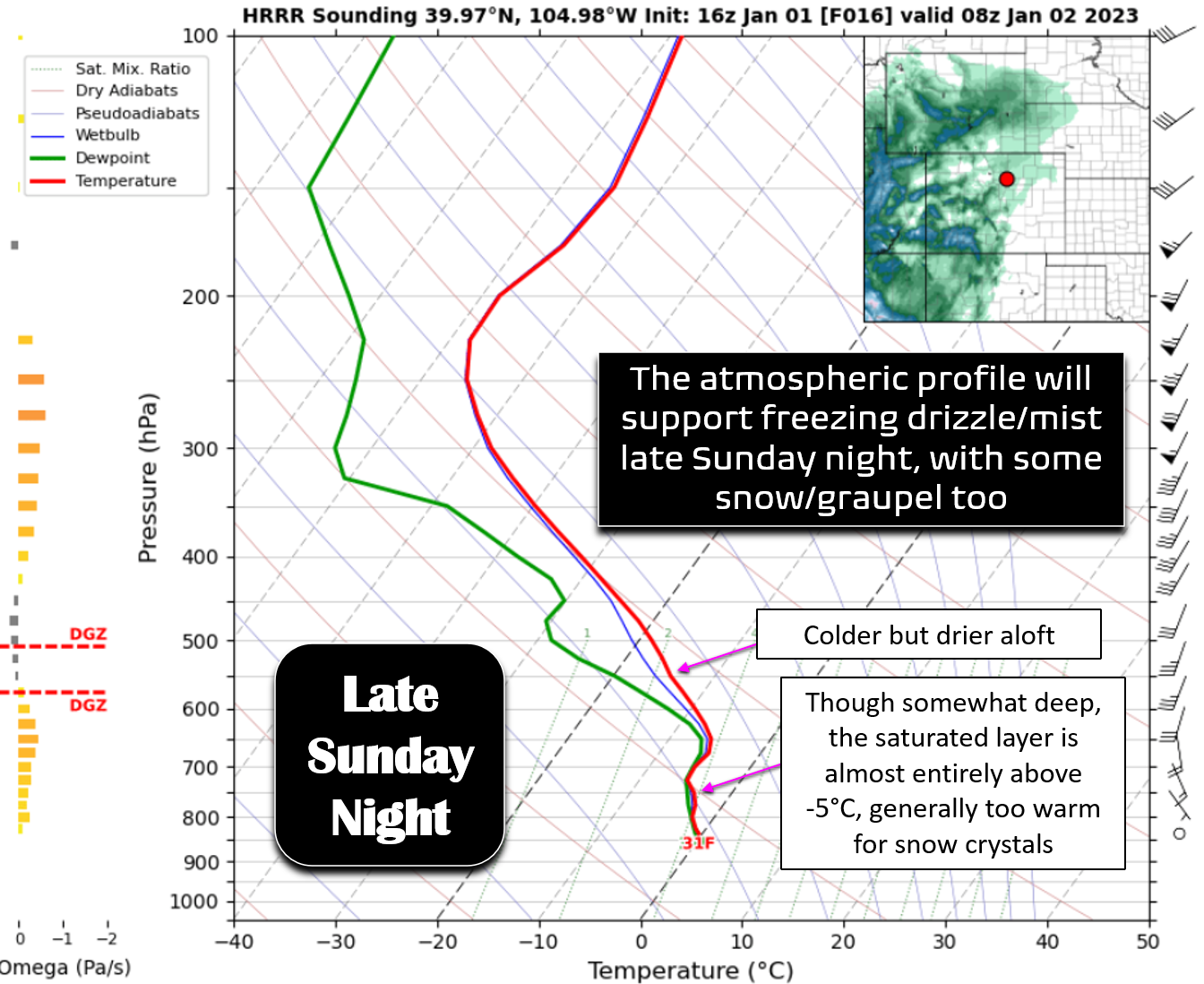
There could be a slight break in the action Monday morning, or things may be more continuous flowing from freezing drizzle into snow — it’s hard to tell exactly as there may be a dry slot across the area. Either way, the main snow event will take place during the day Monday as the mid-level low kicks out into northeast Colorado. Once this happens, areas from Boulder to Cheyenne will be at risk for heavier snow in the deformation zone to the northwest of the low (though we bet this ends up too far northeast of our area).

This won’t be a particularly upslope-driven event as winds aloft take on a downslope component pretty quickly Monday morning. The best upslope will be in Larimer County and in southeast Wyoming. This rapid shift to downslope could dry out the Front Range earlier than expected, especially over the higher Foothills. Models don’t really show this downslope having too much impact in the lower Foothills and Plains, but that is somewhat suspect.
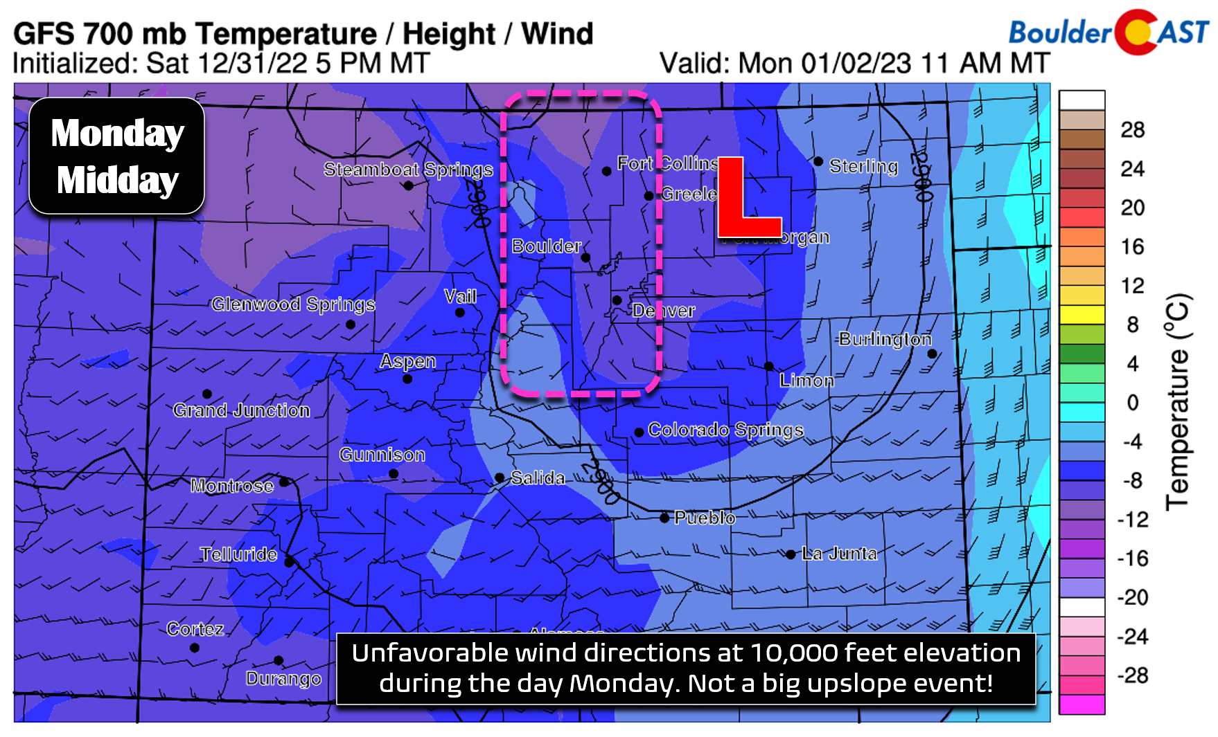
It’s not the upslope that will be driving our snow this time — it’s more so the tightly-packed mid-level low pressure across northeast Colorado doing the heavy-lifting. A preliminary look at the HRRR model-simulated radar indicates the rotation and the potential for heavier snow basically from Boulder northward to Fort Collins and eastward towards the Nebraska border during the day Monday. Where exactly this tight deformation zone sets up will control who sees the decent snow. Unlike the last storm where the bullseye was on Jefferson County (Golden, Evergreen & Littleton), this one should favor the northern Front Range (Fort Collins & Greeley) due to the track of the low pressure. Locations south of Interstate 70 will see lesser snowfall amounts.

Here’s a look at the latest precipitation forecasts from the global GFS and Euro models below. Remember that earlier we mentioned the Euro model is an outlier with its more southern track — so our resulting forecast will lean closer to the GFS solution below. The GFS shows around 0.2″ of moisture for Denver but closer to 0.4″ from Boulder northward. Of note, it’s intriguing to see that the Euro’s more southern track actually produces less precipitation over our entire area, rather than more!
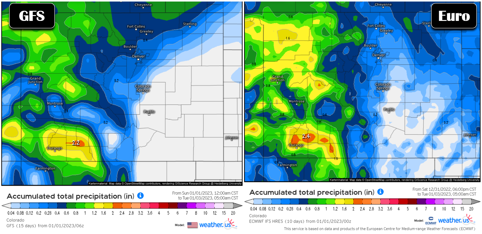
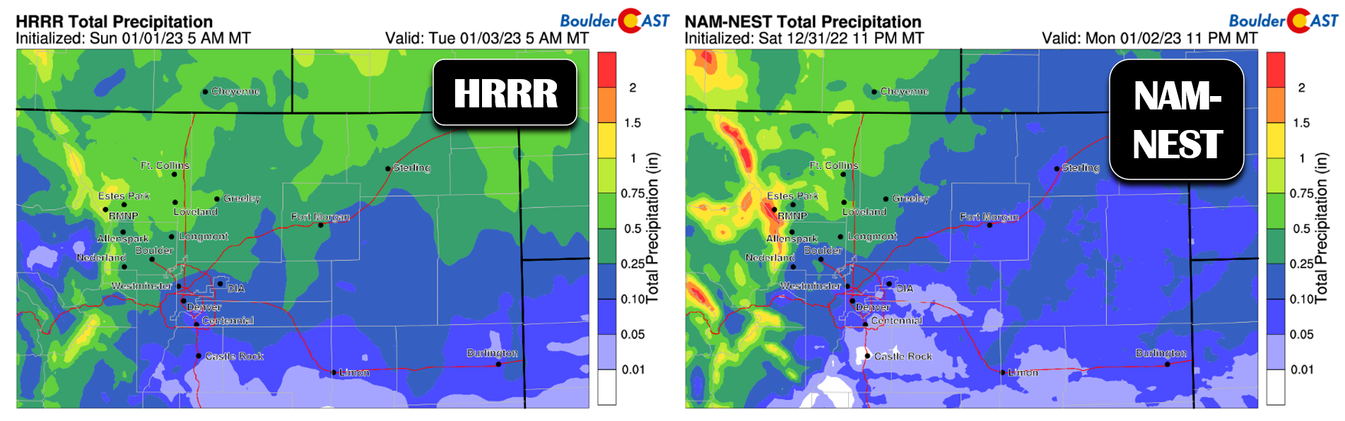
The short-range models are closely aligned with the GFS solution as well. This spatial distribution with less snowfall south and east AND more north and west is our current expectation for this event.
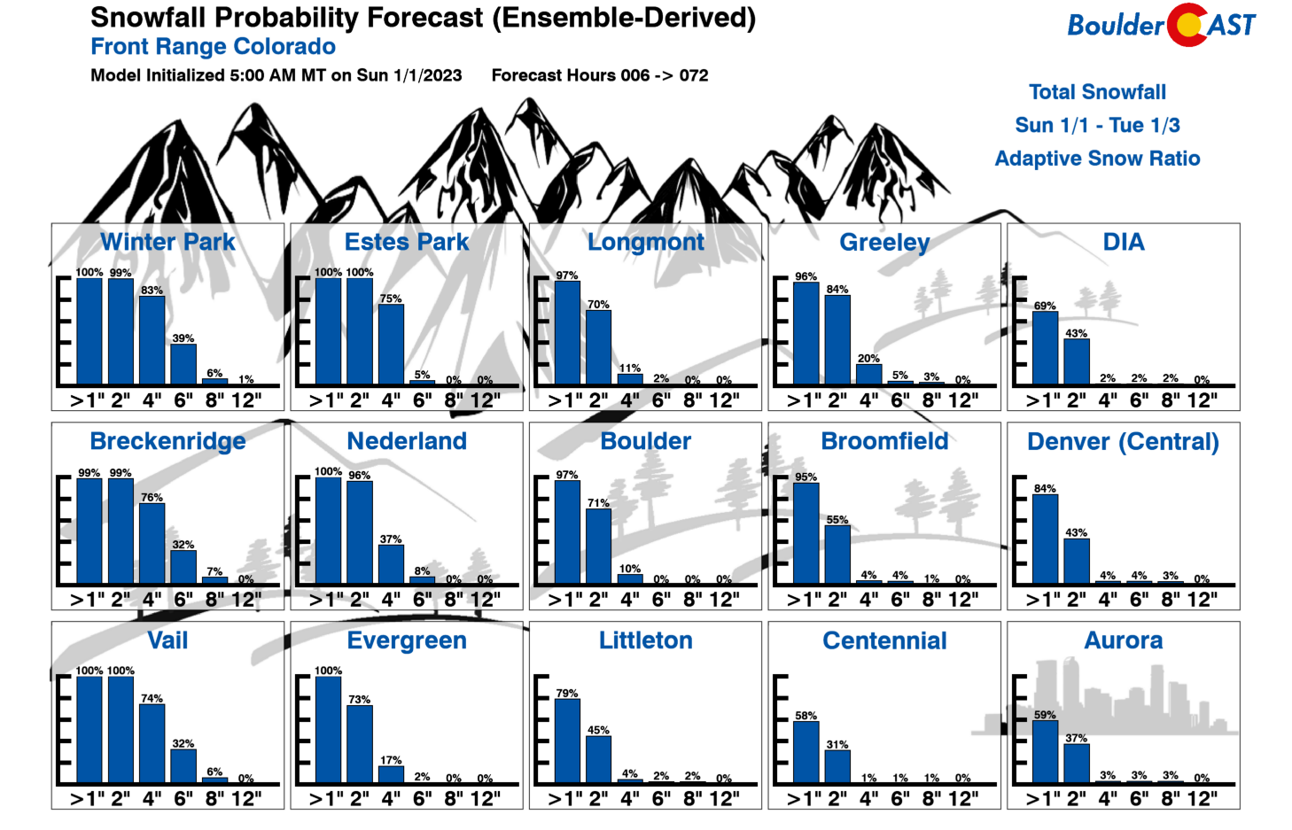
Our snowfall forecast map for the first somewhat minor winter event of 2023 is shown below covering all snowfall through Tuesday morning. Several inches of snow are possible for the northern Metro area, with as little as 1″ in the southern part. Areas along and west of the Divide can expect bigger totals. Remember, this is a long-duration, multi-phased event. You won’t see all this snow appear at once. The best potential for more substantial pockets of snow is Monday afternoon into the evening, but again this may end up being too far north and east. Snowfall will wrap-up completely late Monday evening.

Our Snowfall Probability Charts can give you an idea of the potential spread in snowfall amounts at your location. It is clear the northern cities have the best odds of seeing 2″ or more of snowfall, though odds drop off quick for any higher amounts.
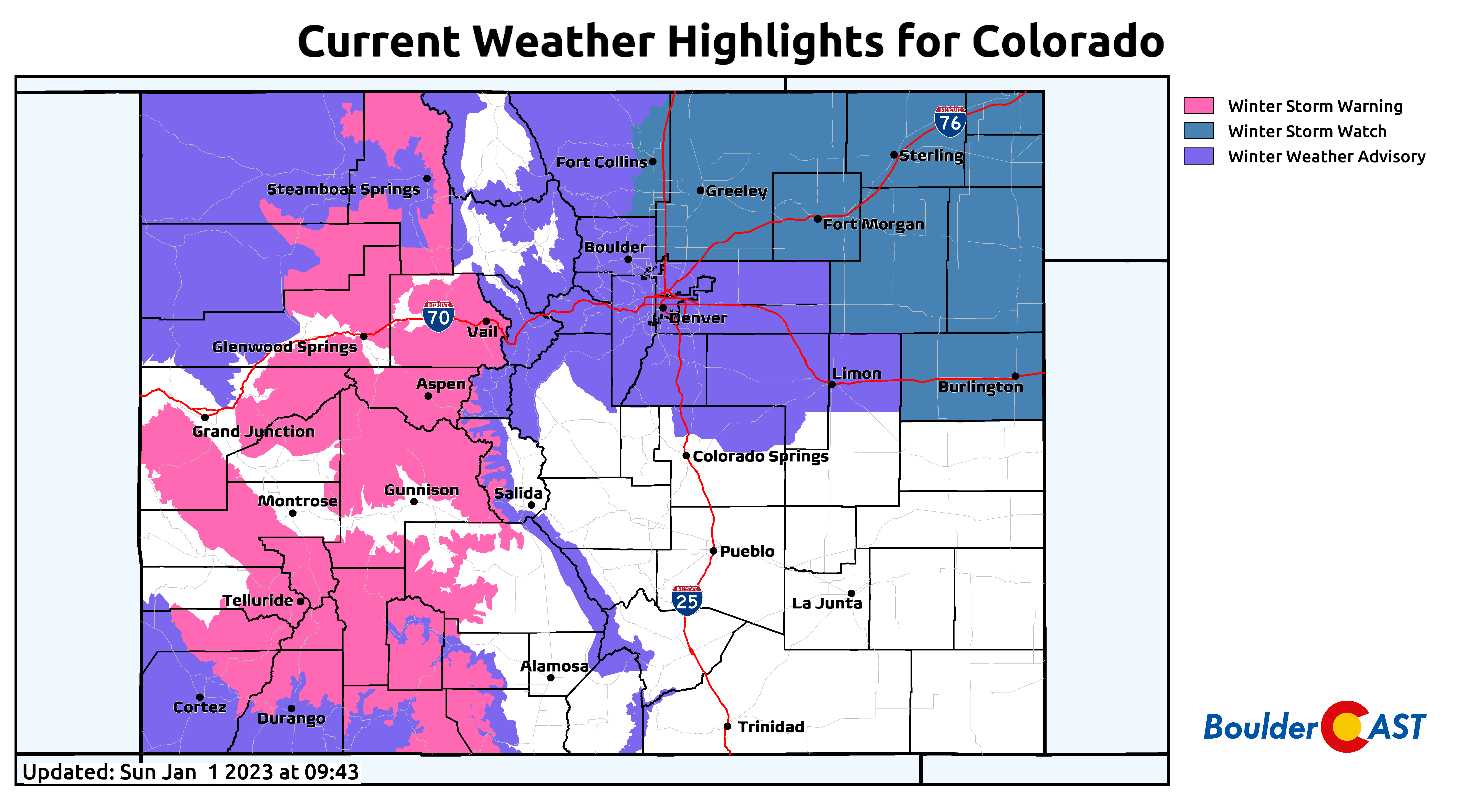
Winter Weather Advisories are already posted for the entire immediate Denver Metro area and go into effect at 8:00PM Sunday evening before the mixbag precipitation begins. Use caution if traveling Sunday night into Monday, especially before the snow when freezing drizzle on roadways will be a big issue.
We also want to mention that the snow ratios will rise back up towards normal for this first snow of 2023. It won’t be that dense soupy stuff we had last week. We’re expecting snow ratios around 13:1 for this event. Not complete fluff, but definitely easier on everyone’s back when shoveling!
Winter Storm Timeline
- Freezing drizzle, mist and fog — mixed with bursts of snow — will develop late Sunday evening and continue into Monday morning leading to slick travel conditions. Less than 1″ of snow accumulation is expected before sunrise Monday on the Plains, with up to 2″ in the Foothills.
- A better chance of snow will unfold during the day Monday and continue into Monday evening. Snow could be heavy at times northeast of Boulder/Denver with snowfall rates >1″ per hour.
- High temperatures only around 30 degrees on Monday
- Snow comes to an end fully Monday night with storm total accumulations ranging from 1 to 5″ across the Front Range, highest to the north and lowest southeast of Denver
- Mountain snow will continue through Tuesday with winter driving conditions all but guaranteed to persist. Skiers will enjoy great snow conditions for the next several days, regardless of your resort of choice!
- Outside of the Mountains, only minor travel impacts from the snow and ice are expected with this event

Check back later today for updates as we may tweak our snowfall forecast map some, or just stay subscribed to always be in the loop! And now onto the weather for the rest of the week…
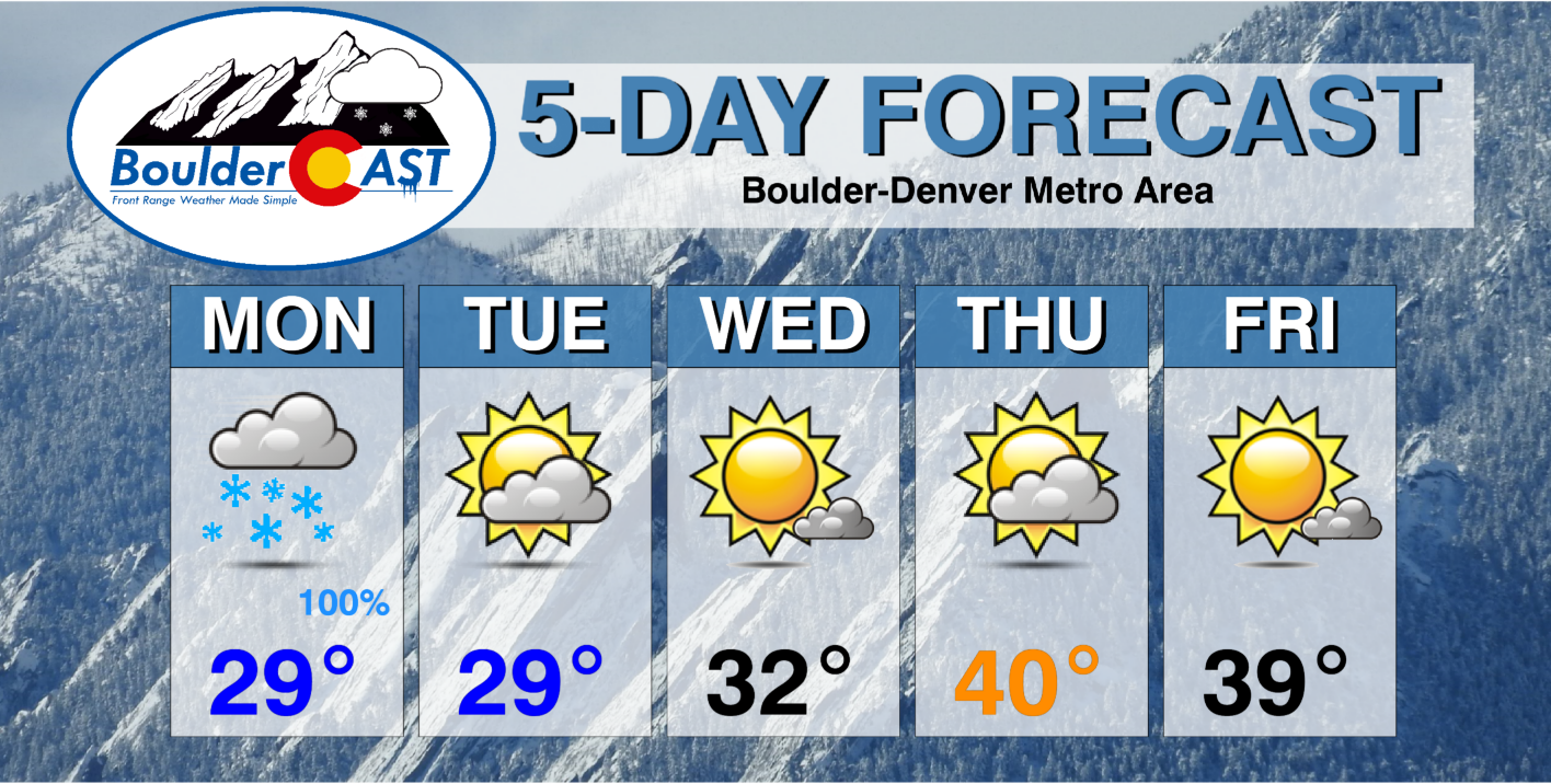
The rest of the week is cool but dry
After the early week snow and cold, things will be mostly quiet for the rest of the week across our area. The active storm track will continue one more day through Tuesday, but almost all of the moisture on Tuesday will get absorbed by the Mountains. Wednesday into Thursday a shortwave ridge will build across the Rockies with sunshine and slightly warmer temperatures returning but still sticking below seasonal normals. A very potent trough will develop over the northeast Pacific Ocean in the coming days with another major atmospheric river event unleashing on California mid to late week. Most models keep a bulk of this moisture away from Colorado, though we can’t rule out some lighter snow returning to the High Country around Friday or so.

Here’s a look at the next five days in the Front Range. Have a great week and once again, Happy New Year!
Get BoulderCAST updates delivered to your inbox:
Enjoy our content? Give it a share!


You must be logged in to post a comment.