The Front Range is heading into a stretch of intense summer heat this week, with a dominant high-pressure system set to lock Colorado into several days of sizzling temperatures and dry skies. Expect highs in the mid to upper 90s every day through Friday. While Boulder isn’t guaranteed to break any record high temperatures, past patterns suggest we could run hotter than models are currently predicting—something worth watching as it would bump up the heat risks in the Metro area. Relief is on the horizon, though: a cold front late Friday should bring a sharp cooldown just in time for the weekend with at least low-end chances for storms returning.
This week’s highlights include:
- Extended Heatwave: A strong high-pressure system over the Southwest will dominate Colorado’s weather this week, bringing hot and dry conditions.
- Ridge Expansion: The ridge will intensify and expand northeastward, locking the Front Range into several days of mid to upper 90s.
- Downslope Flow: West-southwest winds aloft will enhance warming, potentially pushing temperatures near record highs—though Boulder isn’t guaranteed to break any.
- Model Discrepancy: Historical analogs suggest temps could run hotter than current forecasts, a result that would increase the risk of heat-related health impacts.
- Cooler Weekend Ahead: A cold front arriving late Friday should end the heatwave, with highs dropping into the 80s or 70s by Saturday.
- Dry Then Slightly Stormy: Expect dry conditions through Thursday; low chances of storms return Friday into the weekend, mainly in higher elevations.
- Snow Talk: We end the discussion on a cooler note with a look at recently cold and snowy happenings in Colorado.
DISCLAIMER: This weekly outlook forecast is created Monday morning and covers the entire upcoming week. Accuracy will decrease as the week progresses as this post is NOT updated. To receive daily updated forecasts from our team, among many other perks, subscribe to BoulderCAST Premium.

Go Premium, get all the perks.
Daily Forecast Updates
Get our daily forecast discussion every morning delivered to your inbox.
All Our Model Data
Access to all our Colorado-centric high-resolution weather model graphics. Seriously — every one!
Ski & Hiking Forecasts
6-day forecasts for all the Colorado ski resorts, plus more than 120 hiking trails, including every 14er.
Smoke Forecasts
Wildfire smoke concentration predictions up to 72 hours into the future.
Exclusive Content
Weekend outlooks every Thursday, bonus storm updates, historical data and much more!
No Advertisements
Enjoy ad-free viewing on the entire site.
The Front Range Braces for a Scorcher
The Front Range is gearing up for a hot and mostly dry stretch this week, thanks to a stubborn high-pressure system parked over the southwestern U.S. You can actually spot this dry-air-ridden heat dome on Monday morning’s GOES-East water vapor imagery—it’s centered over southern Arizona and expanding fast.
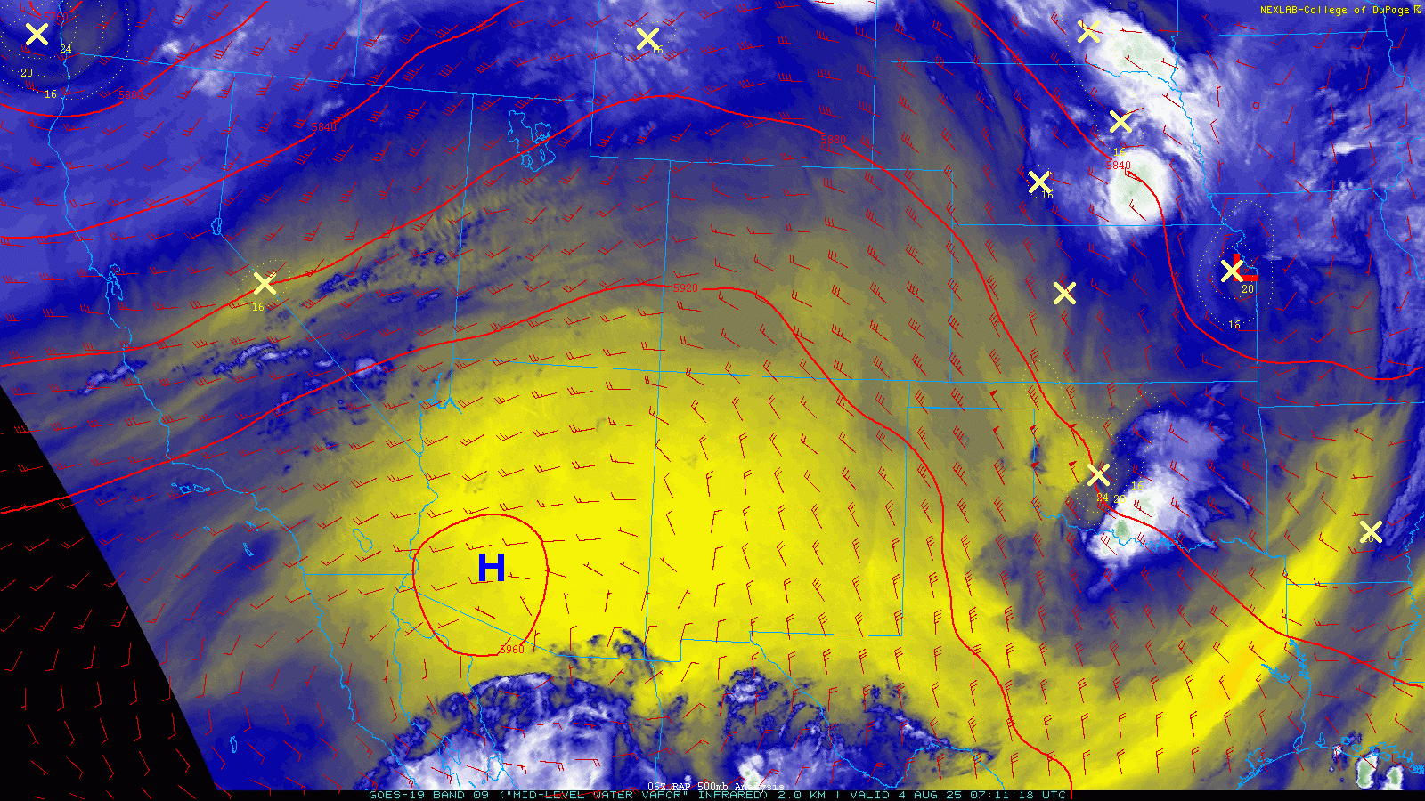
As we move through the workweek, this ridge will strengthen and stretch northeastward, eventually swallowing up all of Colorado. With its core hovering near New Mexico, it’ll lock us into several days of intense heat.
Each day, the ridge’s influence will grow stronger. Aloft, we’ll see west-southwest winds—classic downslope flow—which tends to dry things out and crank up the heat.
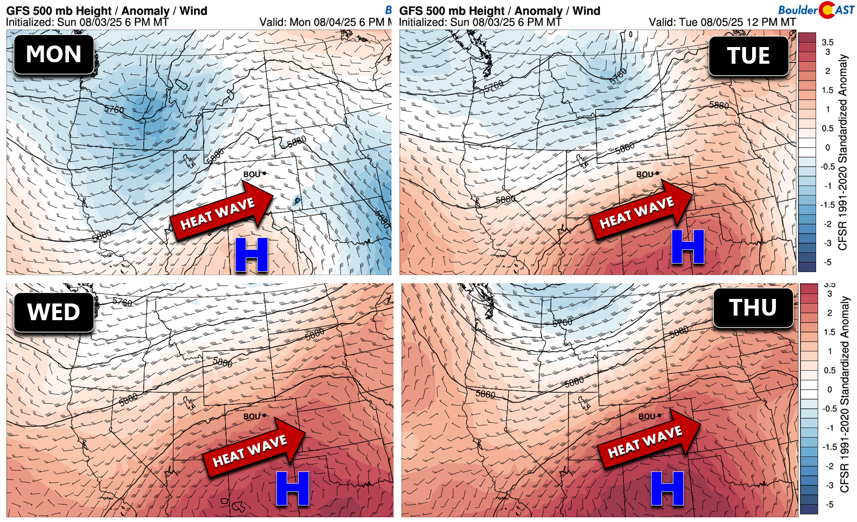
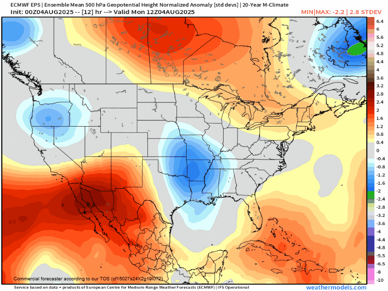
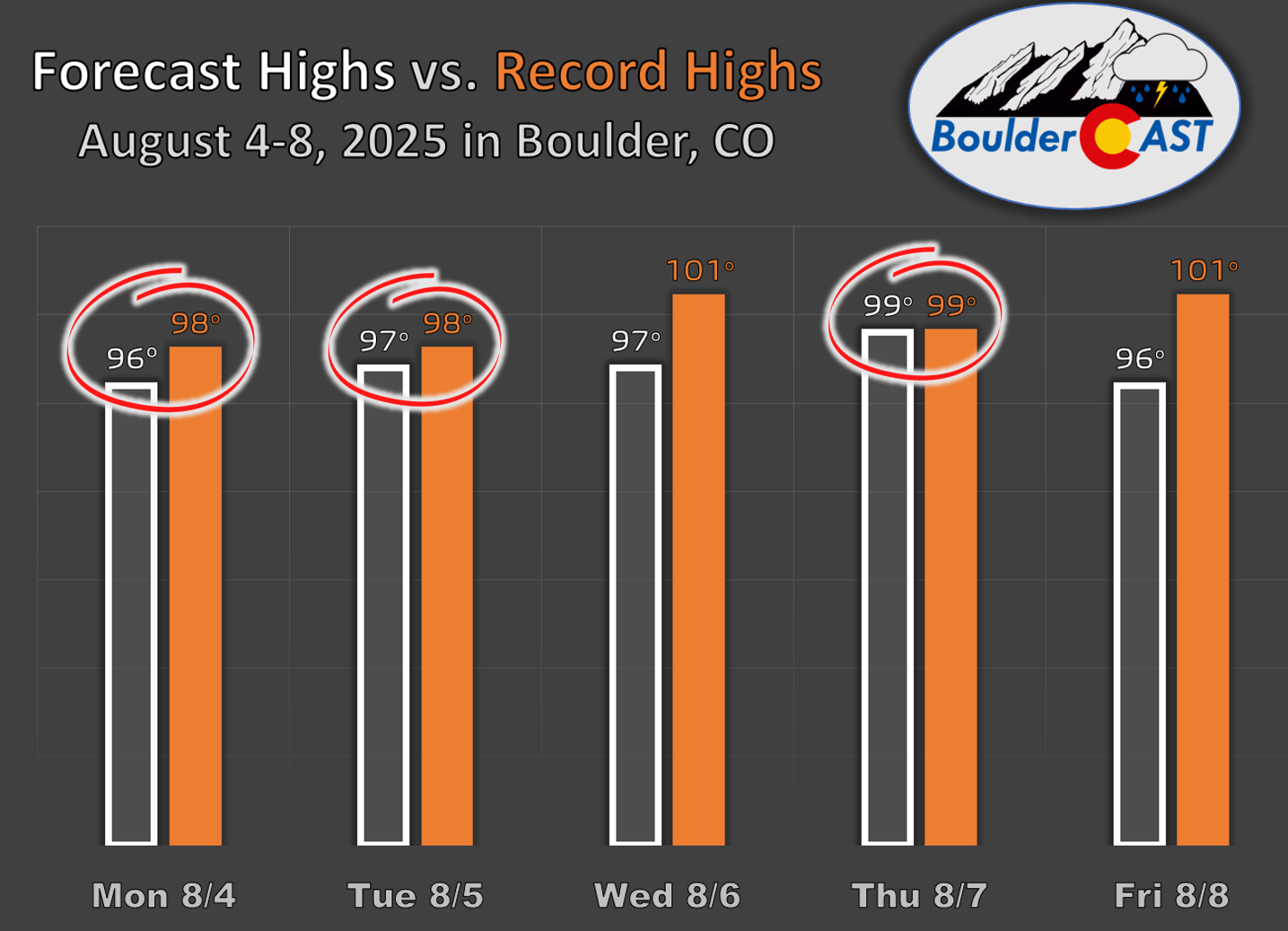
That setup could push us toward record highs across the Front Range, though most models aren’t currently calling for any new records in Boulder. However, there’s a catch: statistical models that look at past patterns like this one are running hotter than the standard operational forecasts. Translation? Historically, similar setups have produced higher temperatures than what the models are showing now. So, we’ll be keeping a close eye on that—just a few extra degrees could amplify the heat’s impact and raise the risk of heat-related illnesses.
Overnight lows will drop into the low to middle 60s so that should offer some nightly help with this heat. Thursday night may cause some issues as it will be several degrees warmer (65 to 73° lows).
Relief Is Coming—Eventually
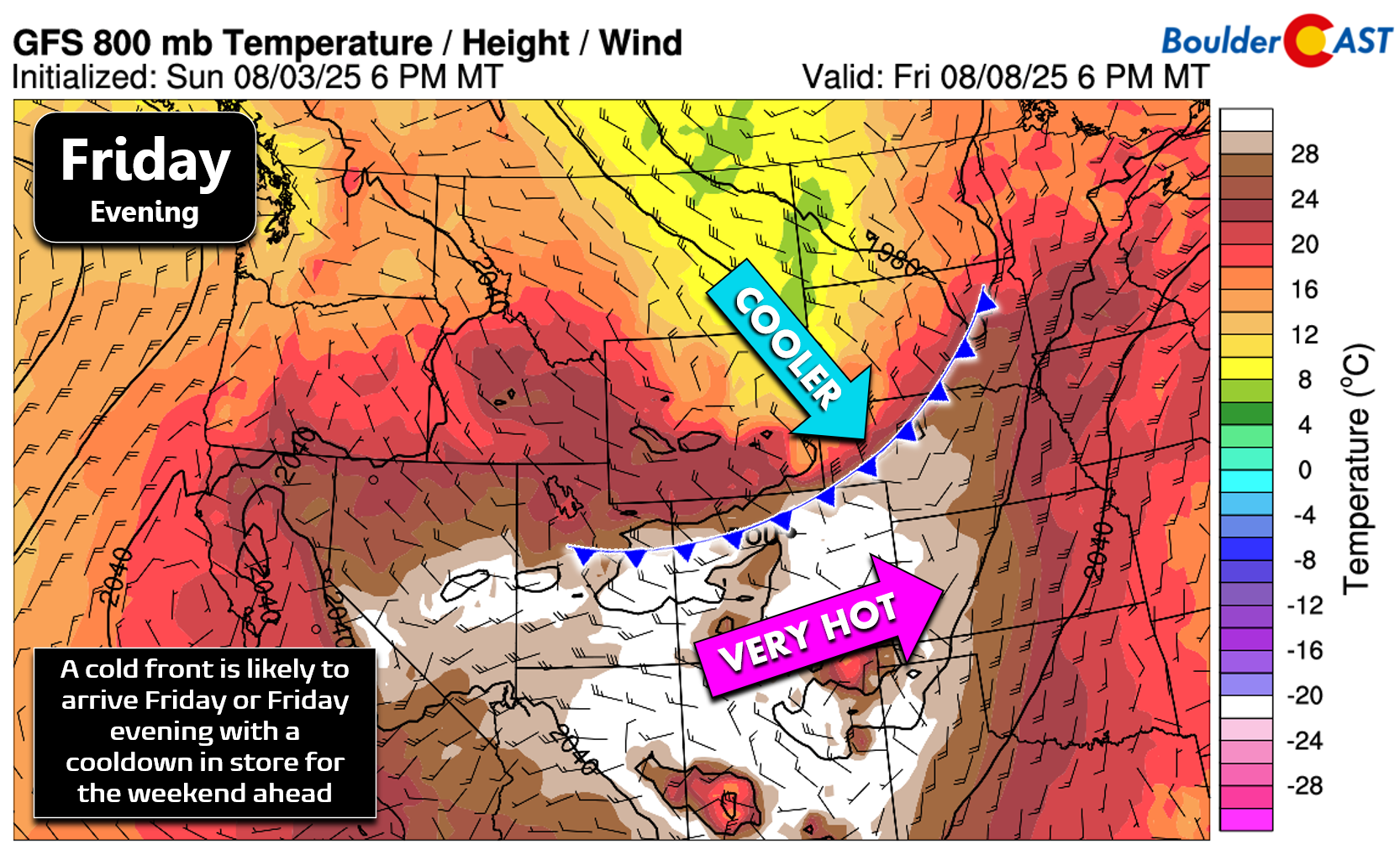
The good news? This heatwave has an expiration date. By late Friday, a fast-moving system will sweep through the northern Rockies and shove a cold front into eastern Colorado. Most models suggest it’ll arrive Friday evening, but if it shows up earlier, we could shave a few degrees off Friday’s high.
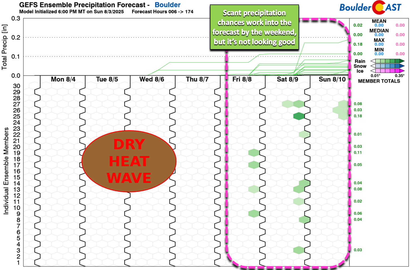
Dry Days Ahead, With a Chance of Weekend Storms
Alongside the heat, expect bone-dry conditions through at least Thursday. Boulder and Denver will stay rain-free while we bake under the ridge. Friday into weekend will offer up low-end precipitation chances. It doesn’t look like much, but there should be a few storm clouds around for the weekend, even if it’s mostly across the higher elevations.
For now, expect one last blast of heat Friday with highs in the mid to upper 90s before cooler air settles in for the weekend. Saturday’s readings should drop into the 80s—or even the 70s if we’re lucky.
Ending on a cooler note
We want to end today’s sizzling forecast discussion on a cooler note. A few days ago we ran into fluffy snowflakes falling in the wildflower-rich alpine tundra near Buena Vista. The videos below were taken Friday morning near 13,000 feet elevation. We see a lot of graupel falling in the Mountains this time of year, but actual dendritic snowflakes is much less common. Still, it can snow anytime of year in the highest peaks of Colorado, but it was definitely a nice treat to start the month of August!
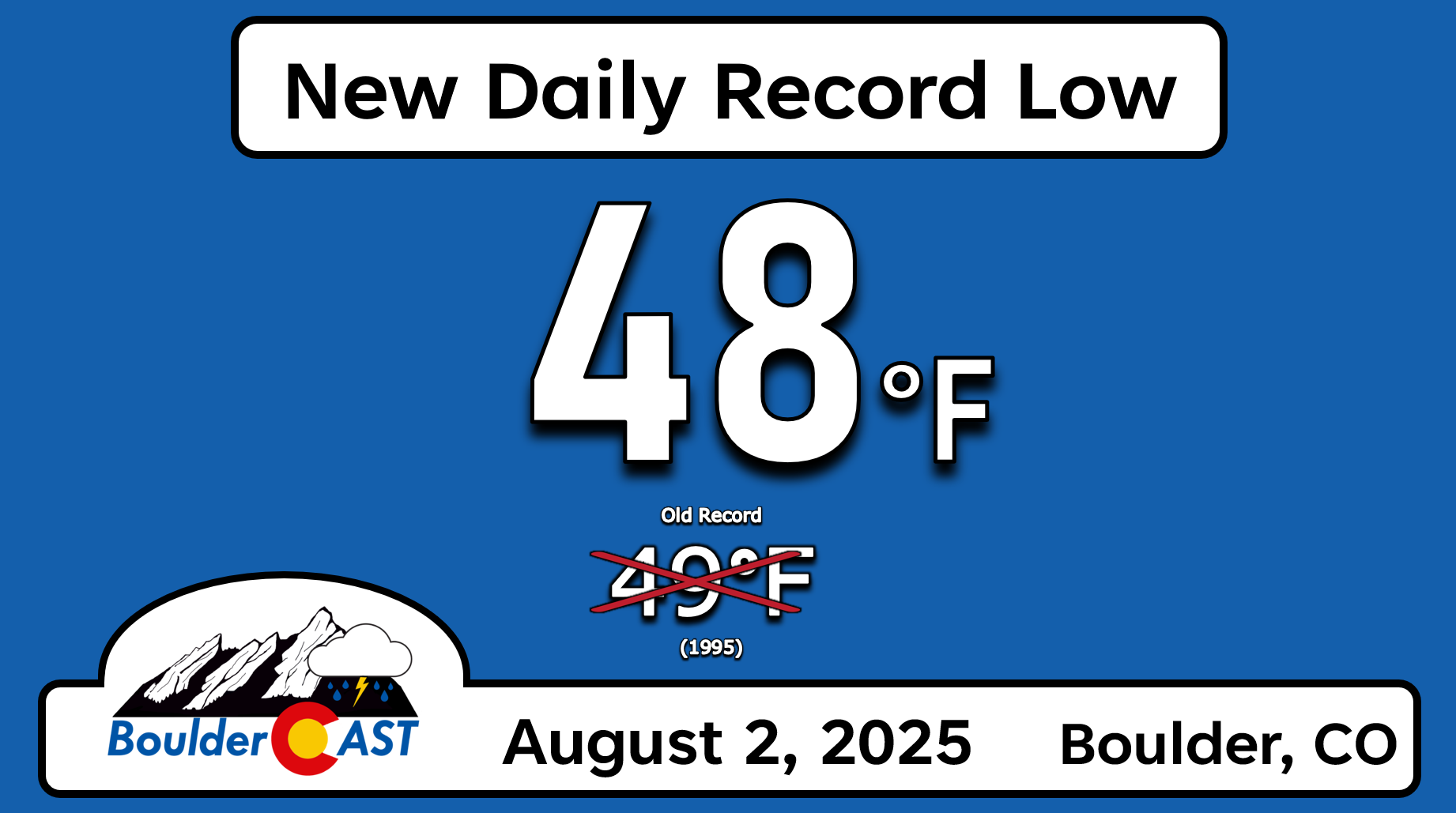
Furthermore, did you know that Boulder set a new record low temperature this past Saturday morning? We got down to a chilly 48°F, the coldest morning here since June 18th. This reading bested the prior record low temperature for August 2nd set in 1995 by one degree!
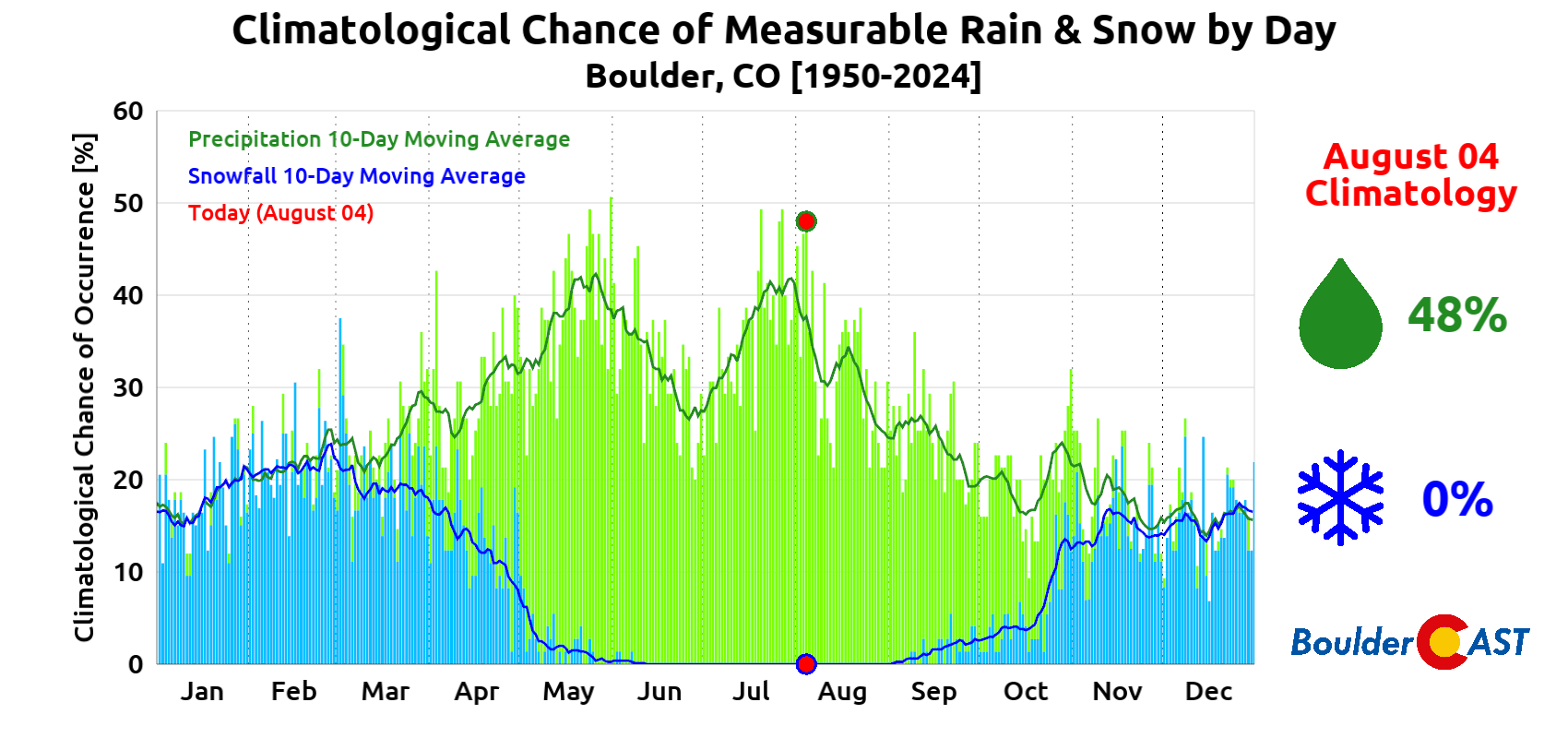
Finally, as we move through the month of August, the intensity of the American Southwest Monsoon will begin to wane. Our daily average precipitation chances drop from over 40% at the beginning of August down to below 25% by month’s end. However, let’s not forget that snowflakes could be falling here in just four week’s time — you didn’t forget about Labor Day 2020 did you?
Enjoy the week and stay safe in the prolonged heat!

Forecast Specifics:
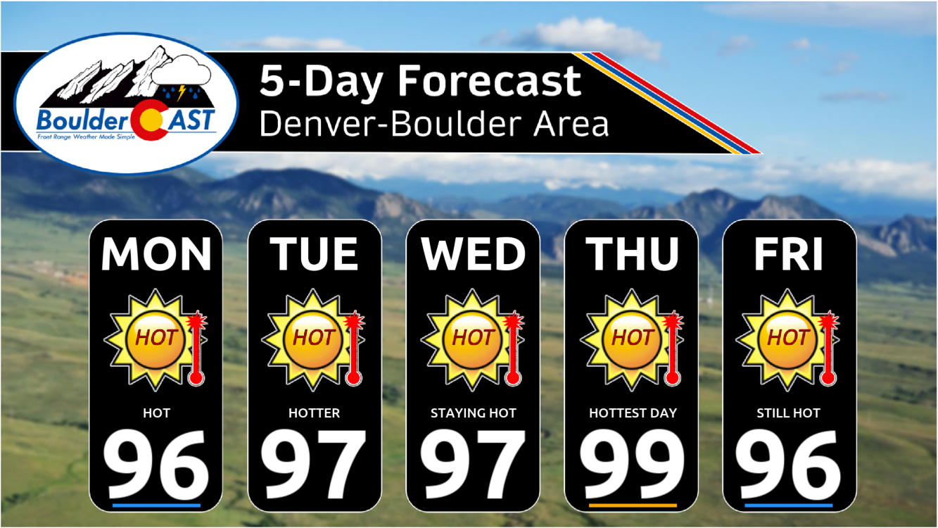
Monday: Morning sun, then partly cloudy and hot with highs in the middle 90s on the Plains with lower 80s in the Foothills.
Tuesday: Partly cloudy and hot with highs in the upper 90s on the Plains with middle 80s in the Foothills.
Wednesday: Partly cloudy and hot with highs in the upper 90s on the Plains with middle 80s in the Foothills.
Thursday: Morning sun, then partly cloudy with highs close to 100 degrees on the Plains with middle 80s in the Foothills.
Friday: Staying hot, though temperatures are more uncertain due to potential late-day cold front. Highs likely push well into the 90s again across the lower elevations with 80s in the Foothills.
Weekend: A cold front arrives late Friday and will usher in cooler weather for the weekend. Highs Saturday around 80 degrees with Sunday into the middle 80s. A slight chance of storms will be around both days (5-20%).
DISCLAIMER: This weekly outlook forecast is created Monday morning and covers the entire upcoming week. Accuracy will decrease as the week progresses as this post is NOT updated. To receive daily updated forecasts from our team, among many other perks, subscribe to BoulderCAST Premium.
Go Premium, get all the perks.
Daily Forecast Updates
Get our daily forecast discussion every morning delivered to your inbox.
All Our Model Data
Access to all our Colorado-centric high-resolution weather model graphics. Seriously — every one!
Ski & Hiking Forecasts
6-day forecasts for all the Colorado ski resorts, plus more than 120 hiking trails, including every 14er.
Smoke Forecasts
Wildfire smoke concentration predictions up to 72 hours into the future.
Exclusive Content
Weekend outlooks every Thursday, bonus storm updates, historical data and much more!
No Advertisements
Enjoy ad-free viewing on the entire site.
Enjoy our content? Give it a share!


You must be logged in to post a comment.