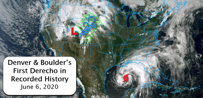
Were you caught off-guard by the historic wind storm that swept across Colorado on Saturday? This type of widespread, damaging wind event is known as a derecho. What transpired on Saturday was the first in recorded history to impact Boulder and Denver. We take a look at the low pressure that caused the event, the astonishing wind reports from across the area, and discuss why this may have been the first and last derecho we ever experience.
At a Glance:
- A widespread, straight-line wind event called a derecho impacted most of Colorado on Saturday June 6, 2020
- Derechoes are extraordinarily rare in the western United States, and especially in Colorado
- Gusts of 50 to 80 MPH were common statewide, with multiple reports above 90 MPH
- This may have been your one and only chance to experience such a weather phenomenon in Front Range Colorado
Help support our team of Front Range weather bloggers by joining BoulderCAST Premium. We talk Boulder and Denver weather every single day. Sign up now to get access to our daily forecast discussions each morning, complete six-day skiing and hiking forecasts powered by machine learning, first-class access to all our Colorado-centric high-resolution weather graphics, bonus storm updates and much more! Or not, we just appreciate your readership!

J
ust one week ago, we posted our annual reminder that the Front Range is entering peak severe weather season and that “if there is one time of year we all need to be extra aware of the weather around us, it is during the month of June!” Of course, we couldn’t have predicted the type of exceptionally rare severe weather that unfolded over the weekend as a complex, long-lived line of thunderstorms blew across that entire state of Colorado like a freight train.
Radar from yesterday's derecho that crossed Colorado. What an event! #Colorado #Weather #Derecho #COwx #Denver pic.twitter.com/YI9ox6i1oF
— Andy Stein (@AndySteinWx) June 7, 2020
This type of dangerous, long-lived thunderstorm complex is known as a derecho (pronounced duh-RAY-cho). If you’re not familiar with that weather terminology, it’s not surprising. Up until Saturday, a derecho had never been observed in Denver or Boulder, and not even within the entire state of Colorado in almost 30 years. The lack of available moisture in our area and the interruption to low-level storm inflow caused by the Rocky Mountains makes derecho formation in the western United States (nearly) impossible. What unfolded on Saturday was truly one-of-a-kind weather for our area!
Graphics from Dennis Cain at NOAA
The nearly 500-mile long continuous squall line of thunderstorms formed along the southeastern flank of a low pressure system moving through Utah. Due to its formation in an area with relatively dry air, this type of derecho is known as a “low dewpoint derecho”. The last derecho to impact Colorado all the way back in 1994 had a very similar large-scale set-up.
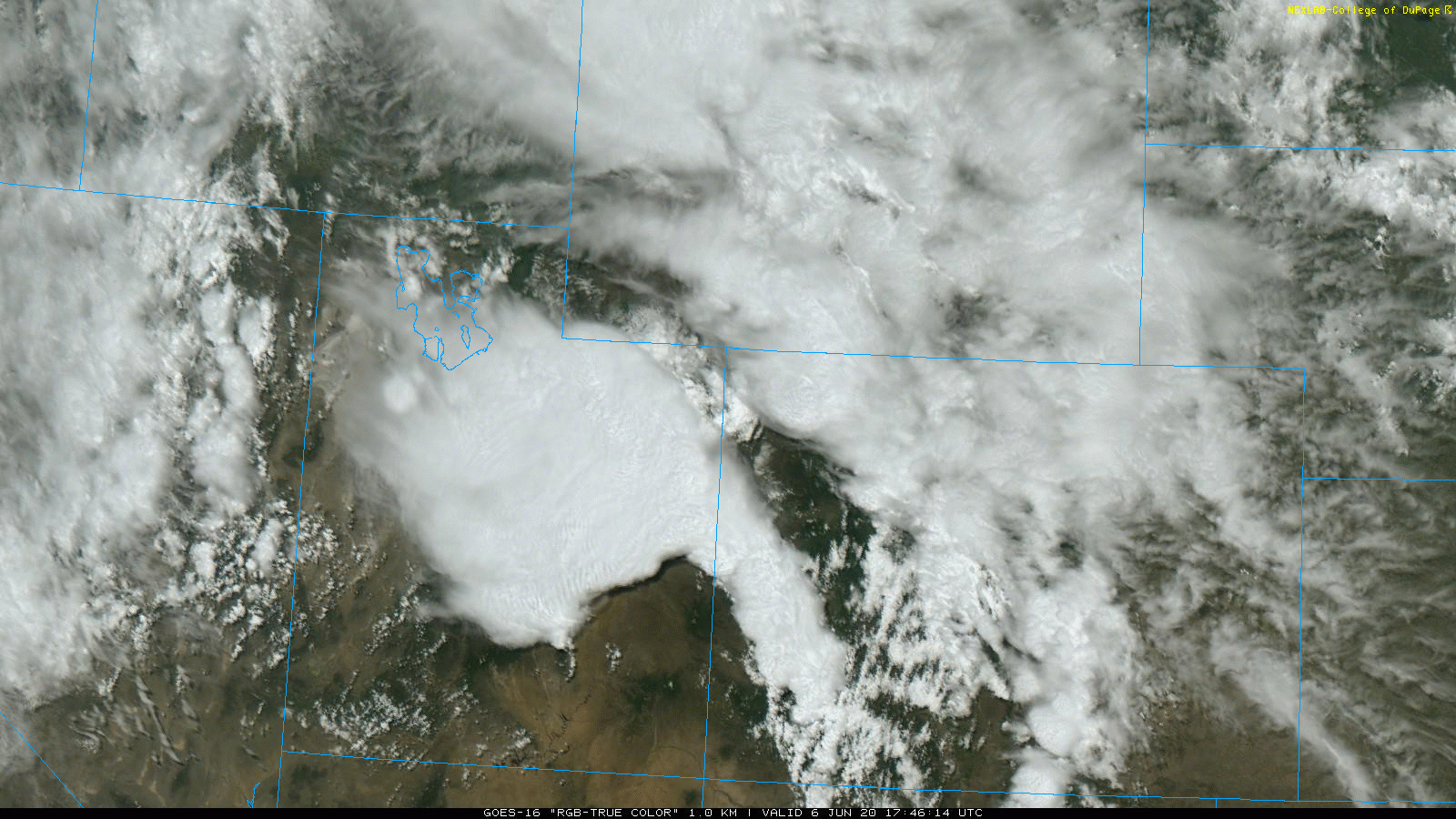
No weather model or meteorologist could have predicted that a line of thunderstorms which initially developed in eastern Utah around mid-day Saturday would race across the heart of the Rocky Mountains at 75 MPH and arrive into the Denver Metro area by early Saturday evening. Derechoes are often well-forecast when the develop in flatter, more “normal” locations (pretty much anywhere east of Colorado), to some degree even a few days in advance. The one that trekked across the state on Saturday was anything but and could not be anticipated beforehand. However, once the pool of rain-cooled air got moving, even the towering mountains in the way couldn’t stop it.
The National Weather Service in Boulder issued a handful of the largest (by geographic area) Severe Thunderstorm Warnings that you will ever see in Colorado. The warning that first included Boulder and Denver gave about 20 to 40 minutes of lead-time for preparation, depending on how close you are located to the Foothills. A Severe Thunderstorm Watch was issued several hours earlier as the derecho began to take shape in western Colorado. Considering the clip these storms were moving, it’s likely some folks were still caught off-guard, which is unfortunate.
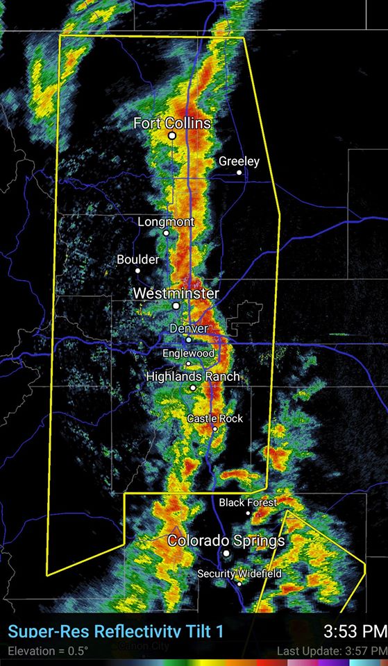
Straight-line winds came roaring through the Front Range during the early evening hours on Saturday, unleashing widespread damaging gusts of 45 to 80 mph. At our location in North Boulder, the most intense winds lasted only a few minutes at best, but the damage was already done.
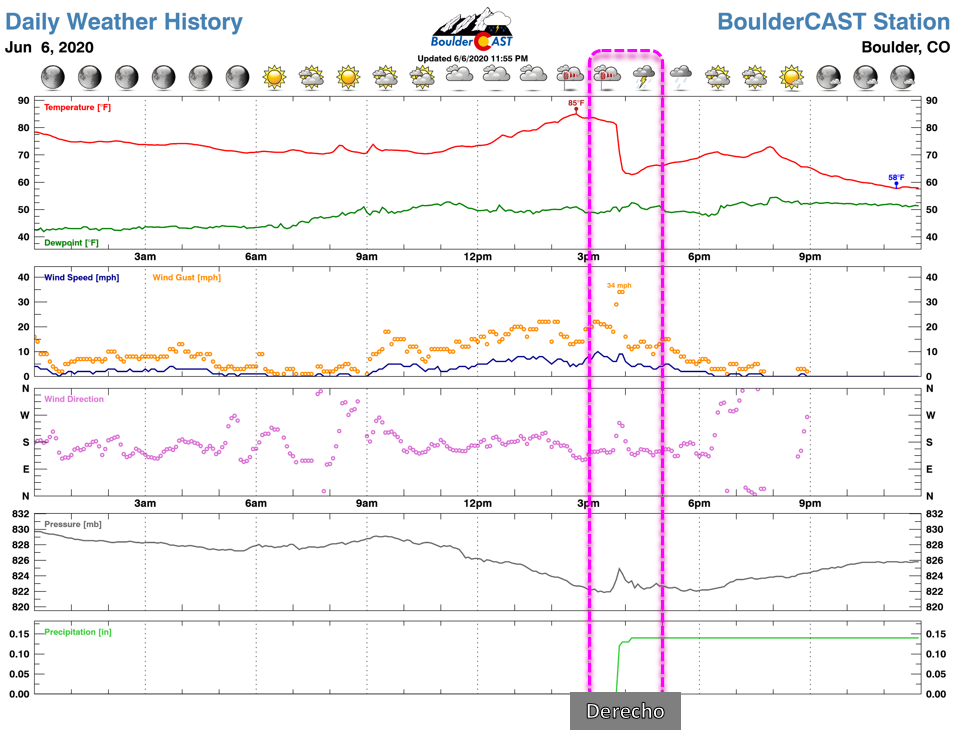
The strong winds uprooted trees, knocked over billboards, flattened fences, punched through windows, tossed outdoor furniture like toys and disrupted power to more than 100,000 residents across the Metro area. Further east, widespread blowing dust was reported as near-hurricane force winds surged eastward out across the drought-stricken Plains of eastern Colorado.
NEW VID: *Regional Severe T*Storm Outbreak Across Colorado*. Severe Windstorm 70-80 MPH Roared Through #Denver Metro This Afternoon. Blinding Dust Storm, Overturned Semi/Trucks, Power Outages & Tree Damage. Sat.06.JUN.2020. With:@BrettNoble4. #Lodo #DIA #WxTwitter #Colorado #COwx pic.twitter.com/RgOMyRcFuA
— William Scherer (@WilliamScherer3) June 6, 2020
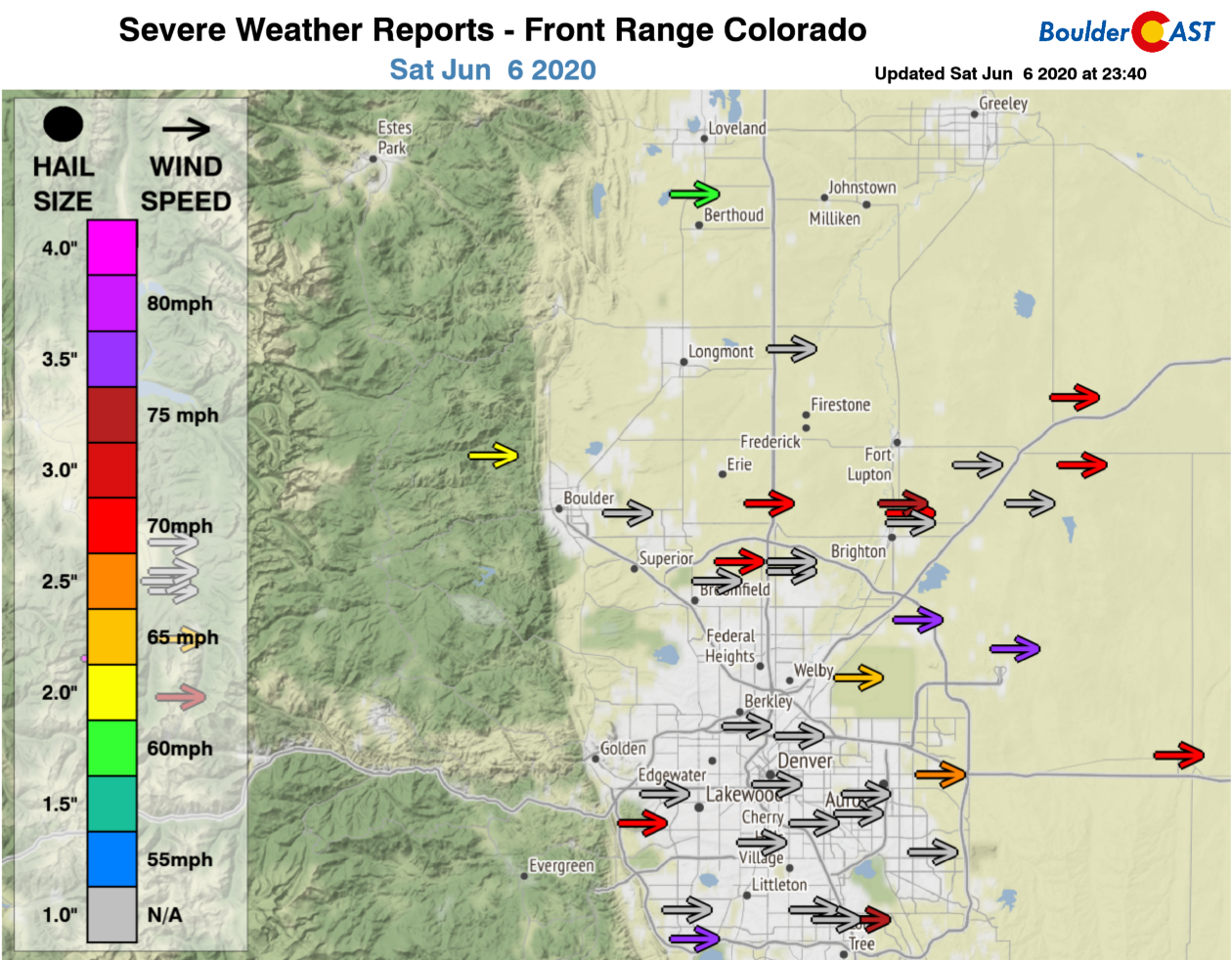
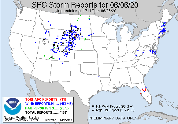
Here are all of the severe storm reports from across the Front Range on Saturday. It was a purely wind event kind of day. While there was some small hail observed in a few of the storms that moved though, it generally was not large enough to be considered severe (quarter-sized or bigger).
Maximum observed wind gusts reported by automated weather stations across Colorado on Saturday show that just about the entire state experienced winds meeting severe criteria (58+ MPH). This alone is absolutely incredible, but does come with the territory of a derecho.
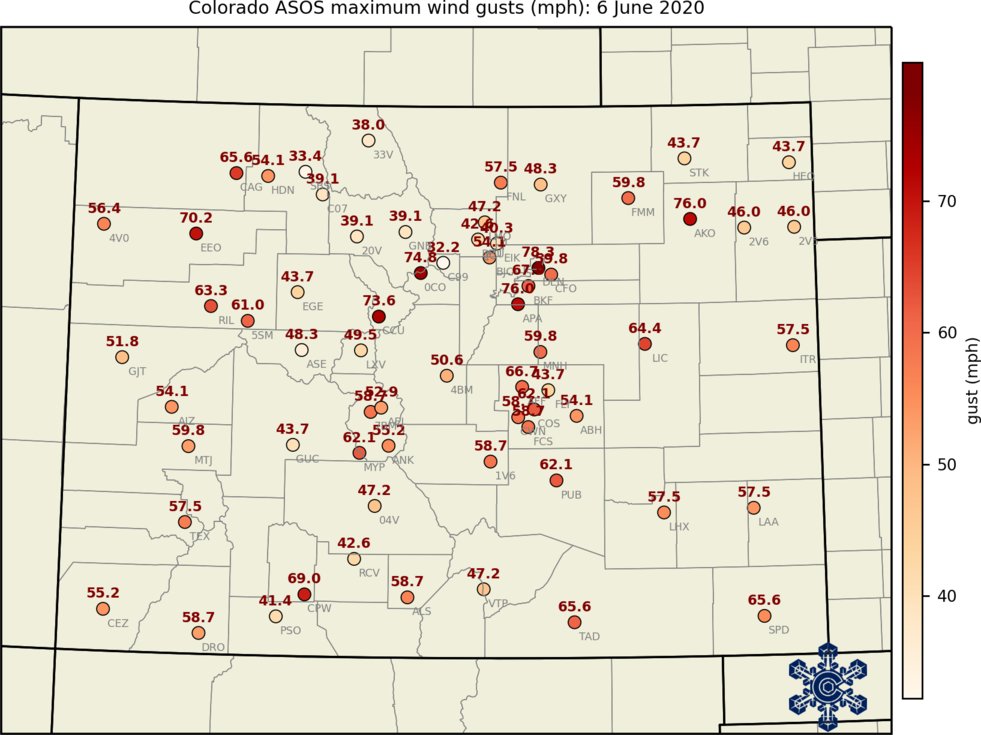
The highest reported gust, not shown on these maps, was 110MPH at the top of Winter Park Ski Area. That’s at 12,000 feet elevation though where 100+ MPH gusts are not terribly uncommon (in the winter…).
Looking even bigger picture, it’s clear that Saturday’s derecho had a larger footprint than just Colorado. The swath of severe wind reports extended nearly 700 miles from eastern Utah, across Colorado and into southwestern North Dakota. The width of the region affected was nearly 500 miles.
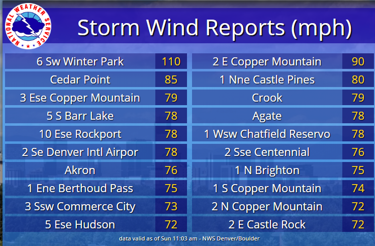
The Storm Prediction Center later noted that Saturday produced the largest single-day total of significant wind reports greater than 75 MPH in their history (dating back to at least 2004, but could be since 1950 if reports are confirmed).
Yesterday's (6/6) derecho produced the most significant wind gust reports in a day (from prelim SPC storm report counts).
Sig wind gusts are estimated or measured severe wind gusts of 75 mph or greater.
Even more impressive, 41 of the 44 significant wind gusts were measured. pic.twitter.com/Tn7Zb2cVnk
— NWS Storm Prediction Center (@NWSSPC) June 7, 2020
Having grown up on the East Coast, it’s clear to me that what transpired on Saturday was on the “wimpy” end of the derecho spectrum, at least from what I observed in Boulder. While the winds were some of the strongest I have seen outside of a winter-time downslope windstorm, the duration was extremely short (just a few minutes). This isn’t surprising. Derechoes, like any thunderstorm, are fueled by warm and moisture-rich unstable air, consuming it like an engine. We just don’t have the type of moisture content in Colorado to support a 500 mile-long line of severe thunderstorms for 12+ hours at peak, absolutely cataclysmic intensity. Read more about the Great North American Derecho of 2012 to see just how devastating these storm complexes can be in the right growth environment.
Let’s hope this is the last time we have to mention the word derecho in Colorado. It certainly was the first.

Subscribe to receive email notifications for BoulderCAST updates:
We respect your privacy. You can unsubscribe at any time.
.
Spread the word, share Colorado weather:
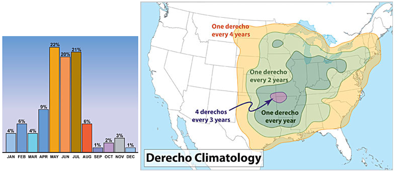
For more comprehensive information on derechoes, their climatology, and how the form, check out this NOAA page.
.


You must be logged in to post a comment.