After a couple cooler weeks, a new ridge of high pressure will form over Utah and dominate the extended forecast across the Front Range leading to a lengthy stretch of 90-degree days accompanied by little to no rainfall. The upcoming Labor Day weekend looks pretty nice across the area as the warmth continues but with some storms popping up in the Mountains. Let’s take a look at the weather week ahead.
This week’s highlights include:
- A weak cold front will drop our temperatures a few degrees on Monday but still with sunny skies
- A persistent, egg-shaped ridge of high pressure will develop Tuesday over Utah and it stays put into the upcoming weekend
- Under this ridge, Tuesday and beyond will be hot in the 90s with very minimal chances of rain in the Denver Metro area
- More of the same weather is expected throughout Labor Day Weekend, but with some storms returning to the High Country

DISCLAIMER: This weekly outlook forecast is created Monday morning and covers the entire upcoming week. Accuracy will decrease as the week progresses as this post is NOT updated. To receive daily updated forecasts from our team, among many other perks, subscribe to BoulderCAST Premium.

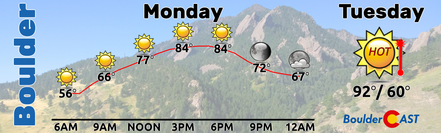
Barely cooler on Monday
The week will begin with a slight cooldown following the passage of a very weak cold front early Monday morning. This front is tied to a low pressure system well to the north in parts of central Canada.
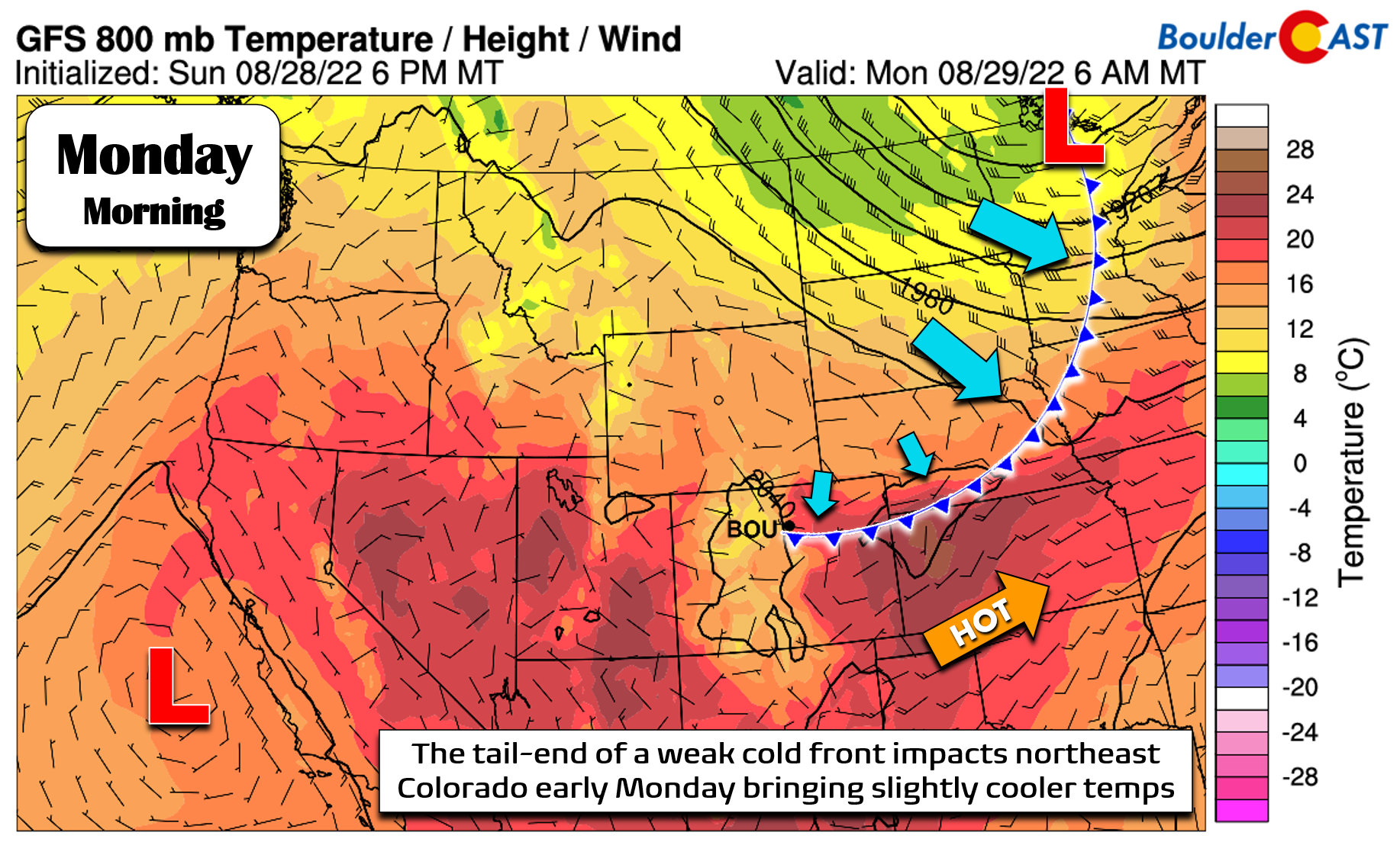
Here’s a better look at where the 993-millibar parent low pressure system is located early Monday.

The temperature gradient across the trailing front is very minor in our neck of the woods. The most notable changes will be a slight wind shift towards upslope in the Denver area, along with a slight uptick in wildfire smoke sourced from California and Pacific Northwest.

After a high of 90°F at our station on Sunday, temperatures will be a few degrees cooler on Monday topping out in the middle 80s. Monday will be dry as well with slight surface cooling and warming aloft working together to prevent convection from forming during the afternoon. Enjoy the beautiful start to the week!
Heating up and staying mostly dry in the extended
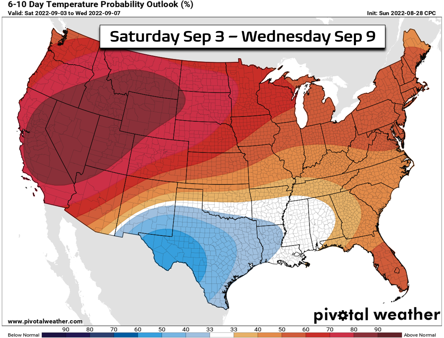
Our main weather player the rest of the week will unfortunately be a developing ridge of high pressure across Utah and western Colorado. The GFS ensemble 500mb height anomaly forecast animation below loops from Monday into Saturday. This ridge will dominate our weather from Tuesday all the way into the upcoming weekend.
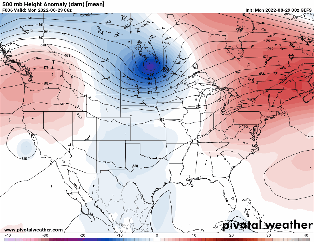
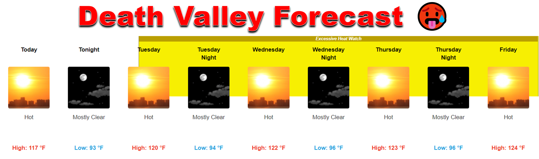
By late Tuesday, the ridge takes on an egg-shape — elongated in the west-to-east direction. It’s this orientation that will completely shut off the flow of monsoon moisture into Colorado while at the same time producing extremely hot temperatures along the West Coast and in the Desert. Hopefully you don’t have plans to visit Death Valley this week as it’s going to be in the 120s!
The Front Range is well-poised to remain east of this ridge and away from the worst of the scorching heat. However, with limited moisture and large-scale subsidence sticking around day after day, the local airmass will receive persistent sunshine and warm-up quite a bit here as well. Our forecast calls for highs in the low to middle 90s Tuesday and beyond in the Denver Metro area — quite the turn of events considering the largely cooler weather we’ve had the last two weeks!
No record heat is expected this week — as Boulder’s daily record highs for the days ahead sit in the upper 90s for the most part.
Fun fact: Today will be Boulder's 11th straight day of NOT reaching 90°F, the longest such stretch during what has been a rather hot summer! 🥵
Also, the extended forecast through the weekend keeps temperatures below 90° as well so this streak should grow! #COwx #Boulder pic.twitter.com/RFRiYBBrOT
— BoulderCAST Weather (@BoulderCAST) August 24, 2022
With days getting shorter, nights getting longer and the potency of the sun diminishing with each passing day, it’s actually very difficult for us to reach 100 degrees this late in the summer. In fact, it’s only happened twice in the last 140+ years in Boulder, including the recent Hotember 2nd of 2019.
This week’s ridging pattern will not be supportive of much precipitation in our area either. A weak system traversing around the northern periphery of the ridge is expected to move through our area Wednesday afternoon and evening with an associated cold front. Models want to fire some thunderstorms in northeast Colorado with this front, but as of now most of the action remains out across the Plains. We’ll have another slight chance of rain on Friday with a similar setup, but that too looks to bring only isolated storms at best — maybe even nothing at all.
The extended outlook for the upcoming Labor Day Weekend is more of the same with above normal temperatures and mostly dry conditions expected to continue across northern Colorado and much of the Intermountain West. We may start to see storms return to Colorado’s Mountains over the weekend, so do keep that on your radar if you have any high-altitude ambitions for the long weekend…

Forecast Specifics:
Monday: Sunny with just a few spotty fair-weather cumulus clouds rolling off the higher terrain in the late-day period. Seasonal with highs in the middle 80s on the Plains and in the middle 70s in the Foothills.
Tuesday: Mostly sunny and warmer with highs in the lower 90s for the Plains and upper 70s in the Foothills.
Wednesday: Morning sun, then partly cloudy with isolated thunderstorms possible in the afternoon and evening, mainly east of Denver. Temperatures in the low to middle 90s on the Plains with lower 80s in the Foothills.
Thursday: Morning sun, then partly cloudy and likely dry. Temperatures stay hot in the lower 90s on the Plains with upper 70s in the Foothills.
Friday: Increasing clouds in the late-day and hot. Isolated storms possible during the afternoon and evening. Highs soar into the middle 90s on the Plains with lower 80s in the Foothills. Some record highs may be challenged.
High Country: The Mountains will largely be dry, warm and devoid of much wind throughout the week ahead under high pressure. A few isolated storms may be possible Wednesday and Friday, but the other days should be dry. A better chance of storms develops over the weekend statewide as high pressure begins to break down.
Help support our team of Front Range weather bloggers by joining BoulderCAST Premium. We talk Boulder and Denver weather every single day. Sign up now to get access to our daily forecast discussions each morning, complete six-day skiing and hiking forecasts powered by machine learning, first-class access to all our Colorado-centric high-resolution weather graphics, bonus storm updates and much more! Or not, we just appreciate your readership!
Spread the word, share the BoulderCAST forecast!


You must be logged in to post a comment.