A very typical, though somewhat boring late-summer week will unfold across the Front Range as the monsoon wraps up and we await the seasonal arrival of the polar jet stream. Our best chance of rain this week comes immediately on Monday as afternoon thunderstorms rock the area. Drier and hot weather will return in the days to follow, however. Late-season monsoon moisture will reach the area Friday into the upcoming weekend, but the heat will be going nowhere.
This week’s highlights include:
- A typical late-summer week will unfold across the area as monsoon season wraps up and we await the seasonal arrival of the polar jet stream
- Thunderstorm activity continues on Monday with scattered late-day storms possible as temperatures top out only in the 70s
- Weak high pressure takes control Tuesday through Thursday with dry conditions and highs returning to the 90s
- A trough comes ashore late week on the West Coast and stalls out — southwest flow ahead of this trough will seed the return of monsoon moisture for Colorado Friday into the weekend
- The stalled trough will for sure keep hot temperatures around in early September with less certainty on rainfall chances
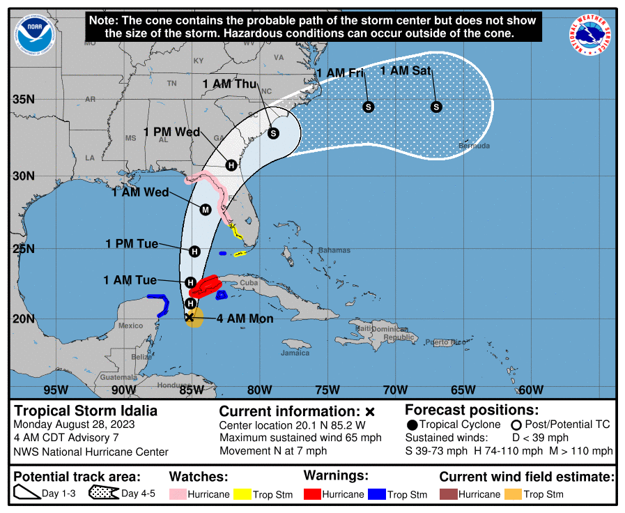
- Tropical Storm Idalia is progged to make landfall in Florida Wednesday as a major hurricane
DISCLAIMER: This weekly outlook forecast is created Monday morning and covers the entire upcoming week. Accuracy will decrease as the week progresses as this post is NOT updated. To receive daily updated forecasts from our team, among many other perks, subscribe to BoulderCAST Premium.

Go Premium, get all the perks.
Daily Forecast Updates
Get our daily forecast discussion every morning delivered to your inbox.
All Our Model Data
Access to all our Colorado-centric high-resolution weather model graphics. Seriously — every one!
Ski & Hiking Forecasts
6-day forecasts for all the Colorado ski resorts, plus more than 120 hiking trails, including every 14er.
Smoke Forecasts
Wildfire smoke concentration predictions up to 72 hours into the future.
Exclusive Content
Weekend outlooks every Thursday, bonus storm updates, historical data and much more!
No Advertisements
Enjoy ad-free viewing on the entire site.
Just a typical last week of August
Despite coming up well short of expectations during last week’s tropically-infused rainfall event, August will conclude at near or slightly above normal in terms of rainfall across the Front Range. Current month-to-date precipitation totals for the region show between 1 and 3″ of rain has fallen. In Boulder, we’ve officially picked up 1.81″ so far this month. The official climate station for Denver, the airport, is a rare outlier having recorded only 0.93″ this month, well below the August norm and roughly half what we’ve seen in Boulder.
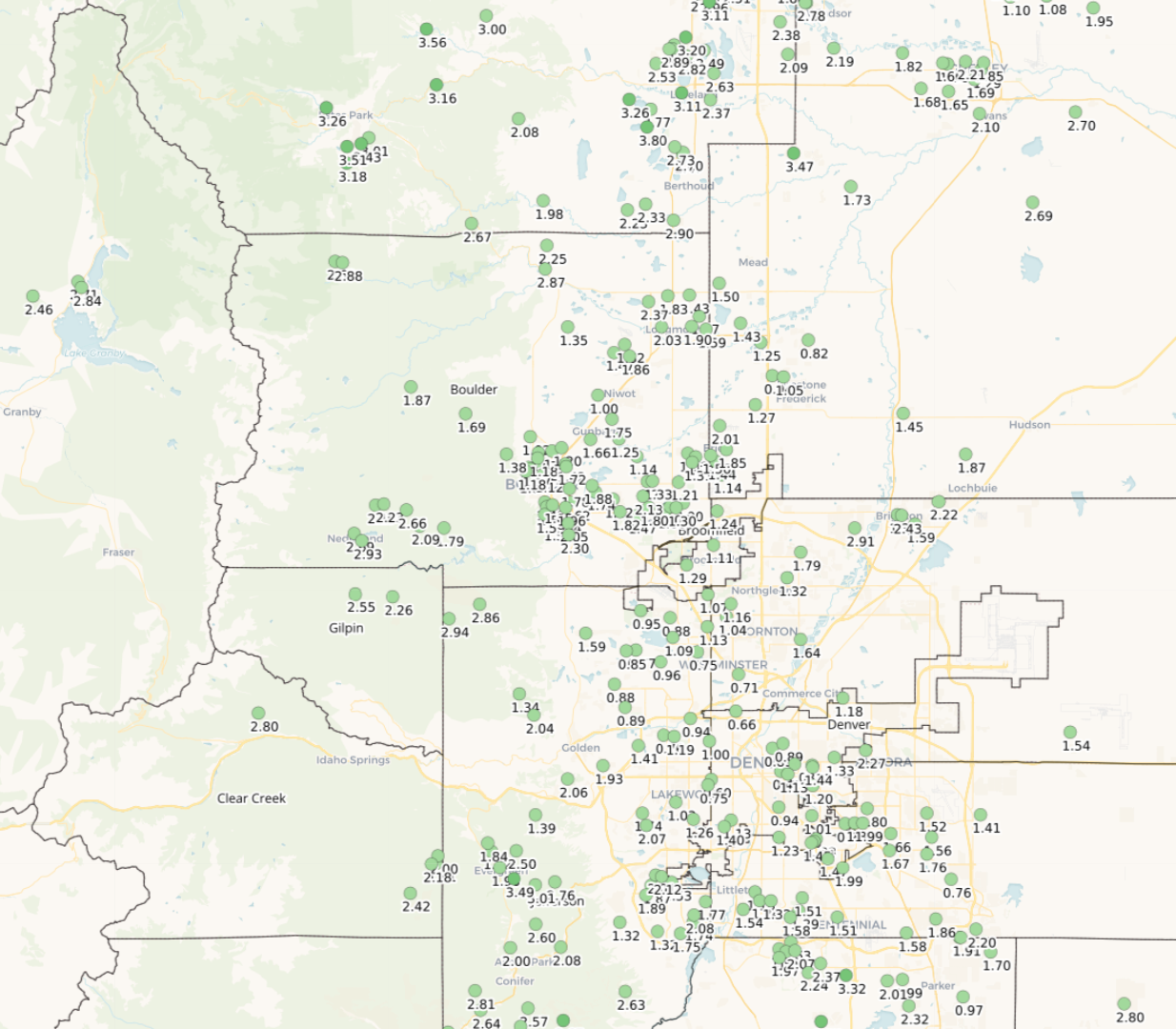
Month-to-date rainfall totals across the area through August 27th.
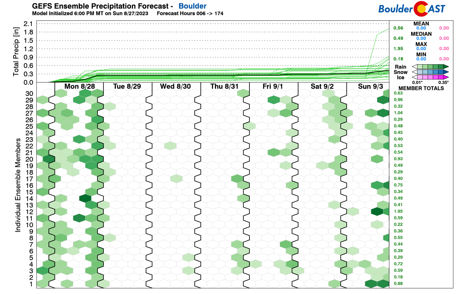
The week ahead will offer a few chances for additional rainfall, but nothing major is expected to boost those August totals, which is typical for late summer as the monsoon dries up and we await the return of the polar jet stream and all the fun weather that comes along with it! The GFS ensembles show that our wettest day in the extended should be Monday, with the remainder of the week notably drier (but not completely dry).
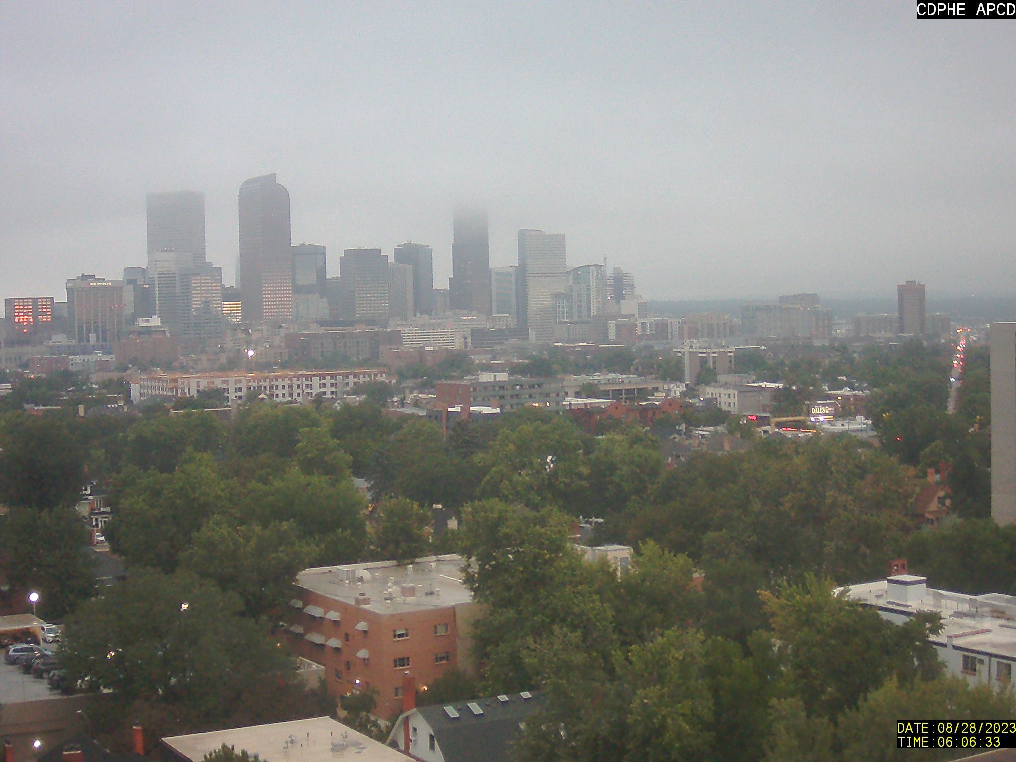
Our Monday will begin with low clouds and areas of fog with some residual moisture lingering behind a cold front that moved through late Sunday night. Some of the taller buildings of the Denver skyline are obscured by clouds on this Monday morning:
Skies will clear to reveal sunshine in short order, however. By afternoon, we expect storm clouds to quickly fill back in, moving off the higher terrain towards Denver and Boulder from the northwest. Scattered showers and storms will be the story Monday with brief moderate to heavy rainfall, small hail, and gusty winds accompanying the stronger cells. Look out for rain anytime from 1PM to 8PM Monday! Highs will be very comfortable to start our week in the middle to upper 70s.
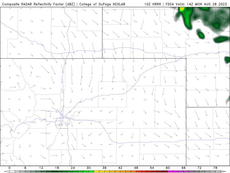
HRRR model-simulated radar animation for Monday. Storms develop in the afternoon and move into the Metro area from the northwest.
Our weather the rest of the week will be mostly influenced by an area of high pressure which begins across southern California on Monday but migrates into Kansas by week’s end.
This high pressure will keep things quiet across the area beginning on Tuesday with northwest flow turning westerly by midweek which will also advect in a fairly dry airmass initially. Subtropical and borderline monsoon moisture will be lurking off to the southwest in Arizona, though. As the next major storm system comes ashore along the West Coast, we may see this monsoonal plume move into Colorado Friday into the upcoming weekend with rain chances spiking again. At this juncture, western Colorado would be more favored to see this moisture than the Front Range as the West Coast system is shown to stall out, but time will tell.
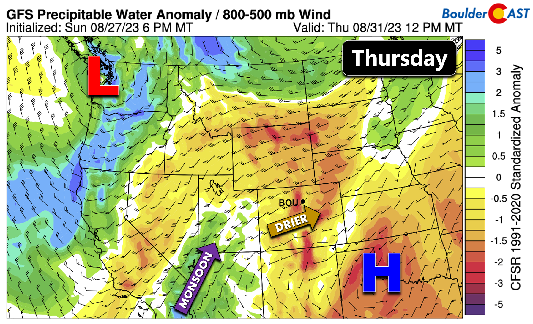
Overall we are expecting dry conditions to prevail across our area Tuesday through Thursday with temperatures warming back above normal into the 90s. There may be a few isolated storms in the higher terrain some of the afternoons, but the lower elevations should be dry due to a lack of moisture. While still somewhat uncertain, we will inject rainfall chances back into the forecast beginning Friday as that monsoonal plume could brush our area. A better chance of storm activity likely comes over the upcoming weekend as the moisture engulfs the area.
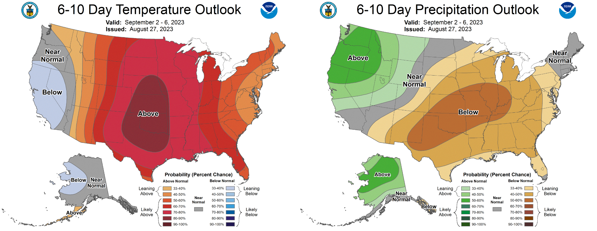
With the aforementioned West Coast trough projected to stall out to our west in the extended, it’s no surprise that the month of September will get off to a hot start with exceptionally high chances for above normal temperatures in eastern Colorado according to the Climate Prediction Center. The rainfall outlook is less certain for early September as the deep southwesterly flow should keep the threat of storms around every day, though chances may never be particularly high. But hey, at least the first week of September won’t be snowing like it was three years ago!
Finally, we will be keeping an eye on Florida the next few days as Tropical Storm Idalia is projected to rapidly intensify and make landfall somewhere along the Gulf-side coast side of the peninsula on Wednesday as a major hurricane.
Enjoy the week!
Forecast Specifics:
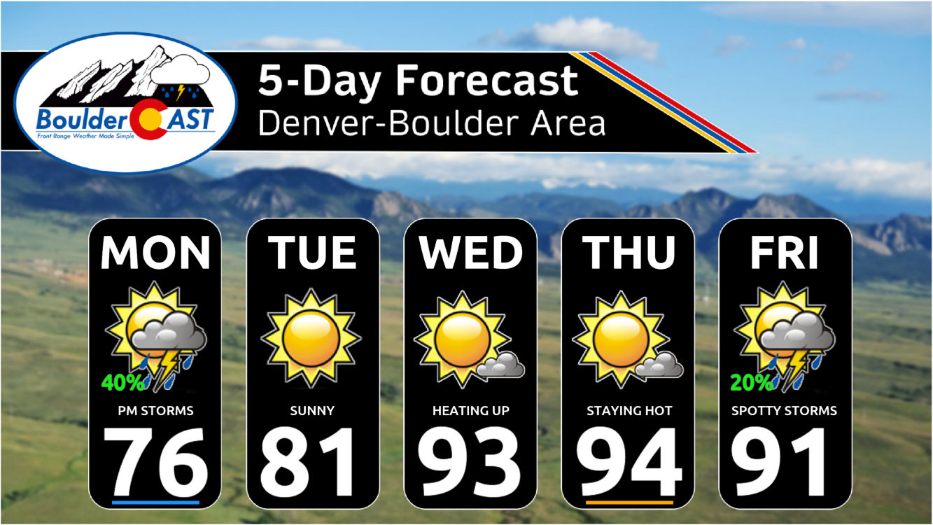
Monday: Low clouds and patchy fog in the morning, then sunny with increasing clouds during the afternoon with scattered to numerous showers and thunderstorms moving off the higher terrain. Storms could contain brief heavy rain and small hail. Highs reach the middle to upper 70s on the Plains with middle 60s in the Foothills.
Tuesday: Exceptionally pleasant with sunshine and dry conditions prevailing. High temperatures top out in the lower 80s on the Plains with upper 60s in the Foothills.
Wednesday: Mostly sunny and dry, but the heat returns. High temperatures soar back above normal in the low to middle 90s on the Plains with lower 80s in the Foothills. An isolated storm or two possible in the higher terrain.
Thursday: Continued dry with a few afternoon clouds. Highs remain toasty in the middle 90s across the Plains and in the lower 80s in the Foothills.
Friday: Morning sunshine, then increasing clouds with scattered afternoon and evening thunderstorms. Temperatures cool a tad into the lower 90s across the Plains with upper 70s in the Foothills.
DISCLAIMER: This weekly outlook forecast is created Monday morning and covers the entire upcoming week. Accuracy will decrease as the week progresses as this post is NOT updated. To receive daily updated forecasts from our team, among many other perks, subscribe to BoulderCAST Premium.
Go Premium, get all the perks.
Daily Forecast Updates
Get our daily forecast discussion every morning delivered to your inbox.
All Our Model Data
Access to all our Colorado-centric high-resolution weather model graphics. Seriously — every one!
Ski & Hiking Forecasts
6-day forecasts for all the Colorado ski resorts, plus more than 120 hiking trails, including every 14er.
Smoke Forecasts
Wildfire smoke concentration predictions up to 72 hours into the future.
Exclusive Content
Weekend outlooks every Thursday, bonus storm updates, historical data and much more!
No Advertisements
Enjoy ad-free viewing on the entire site.
Get BoulderCAST updates delivered to your inbox:
Enjoy our content? Give it a share!


You must be logged in to post a comment.