If you enjoyed the hot and mostly dry weather that dominated the month of July in the Front Range, you’re going to absolutely love the first week of August! High pressure will rebuild over the area this week keeping temperatures well above normal and acting to suppress thunderstorm development most days. The best chance of rain comes on Tuesday, but we also are watching the upcoming weekend when the remnant tropical moisture from Hurricane Frank reaches the area. Let’s take a look at the weather week ahead in Colorado!
This week’s highlights include:
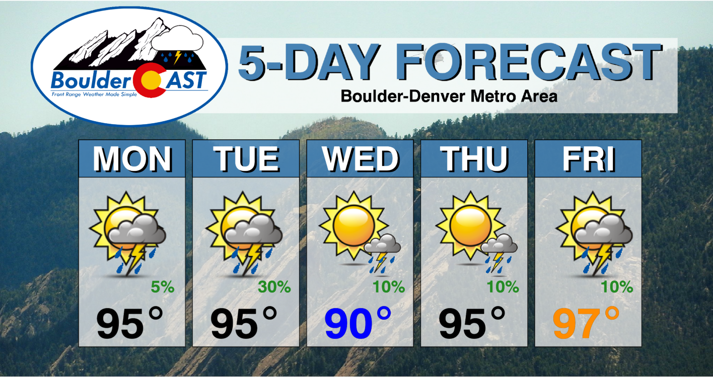
- High pressure remains over our general area through the week with above normal temperatures expected every day alongside minimal rain chances
- The main threat of rain comes Tuesday as a weak disturbance passes across northern Colorado spawning scattered late-day storms
- Wednesday through Friday will see isolated storms possible, mainly in the higher elevations, as the heat tightens it grip on the Denver area
- Tropical moisture from the remnants of Hurricane Frank should reach Colorado over the upcoming weekend with better chances for rainfall arriving
DISCLAIMER: This weekly outlook forecast is created Monday morning and covers the entire upcoming week. Accuracy will decrease as the week progresses as this post is NOT updated. To receive daily updated forecasts from our team, among many other perks, subscribe to BoulderCAST Premium.

The hot & dry pattern of July returns for early August
We kick off the month of August with a transition to a weather pattern that is all too familiar. After a stretch of wetter and cooler monsoonal conditions last week, the large-scale atmospheric setup shifts for the week ahead. We’re moving into the same pattern we experienced much of the month of July — one which brought relentless heat and fairly dry conditions to the Front Range. A look at the setup on this Monday morning below shows:
- High pressure centered over New Mexico — it’s back!
- Rich monsoonal moisture flowing into parts of Arizona, Nevada and California. These areas have seen immense (and unfortunately flooding) rainfall the last few days, at least by desert standards, and that will continue today.
- A heatwave is rocking across the Pacific Northwest and into the Midwest
- The main storm track is situated along the Canadian Border with several weak troughs noted moving across the country
- Tropical Storm Frank off the Baja California coastline is heading northward with a trajectory towards California — it will likely dissipate and stall before ever reaching the coast
- Here in Colorado, the headline this week will be that high pressure center which will move little and will eventually intensify in the days to come.

For Monday, the main concern across the Denver area will be the resurgence of the heat with temperatures soaring back into the middle 90s. There is a slight chance of storms across the higher terrain, but moisture is limited at the moment and thus coverage will be fairly isolated. Some of these storms will try to move east and out over the Denver area, but with little success. See the simulated radar animation below for Monday:
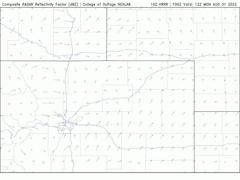
HRRR model-simulated radar animation for Monday. Weak showers develop over the Mountains and try to move into the Denver area
Look for increasing dark clouds Monday afternoon into evening with just a 5% chance of a weak shower producing gusty winds and very light rain.
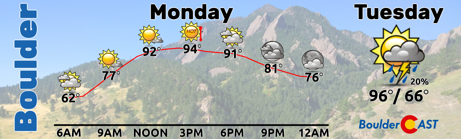
On Tuesday, a remnant monsoonal disturbance will get absorbed into the storm track and then quickly push across Wyoming. In the vorticity forecast animation below, look for the area of spin that originates near Lake Tahoe. Watch as it gets drawn northward and then shoots east. This system will seed the return of scattered showers and storms to northern Colorado on Tuesday as monsoon moisture increases. With more clouds and developing storms around, Tuesday should be a degree or two cooler in most areas with highs in the the middle 90s. The overall track and timing of this system will favor Wyoming more so than our area, but this will sadly be our best chance of rain for the week ahead. Our forecast calls for a 30% chance of afternoon and evening run-of-the-mill storms on Tuesday. With the system not planned to fully clear out until Wednesday morning, some spotty storms may linger into Tuesday night. A weak cold front will accompany this system with temperatures falling back several degrees for Wednesday — but don’t worry….it will still be warmer than average.
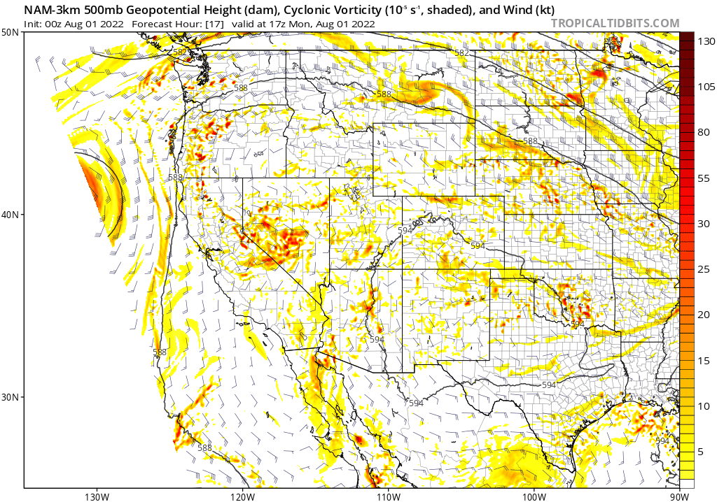
NAM 500mb vorticity forecast animation from Monday night into Wednesday morning showing the weak disturbance sweeping across Wyoming
Wednesday through Friday will see a few things transpire across the West. First and foremost, the large-scale high pressure over the Four Corners region will grow stronger and move further east into the heart of the Great Plains. This setup will see limited moisture across the Front Range initially. With the aforementioned high pressure center acting to suppress convection as well, a drying trend for unfold for us with just isolated storms Wednesday through Friday. The best chance of rain these days, if you want to call it that, will be across the higher elevations, including the Mountains, Foothills and Palmer Divide.
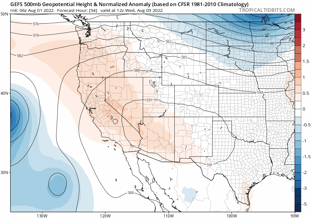
GEFS 500mb height anomaly forecast animation from Wednesday into Saturday. High pressure intensifies and shifts east from the Four Corners into the Great Plains.
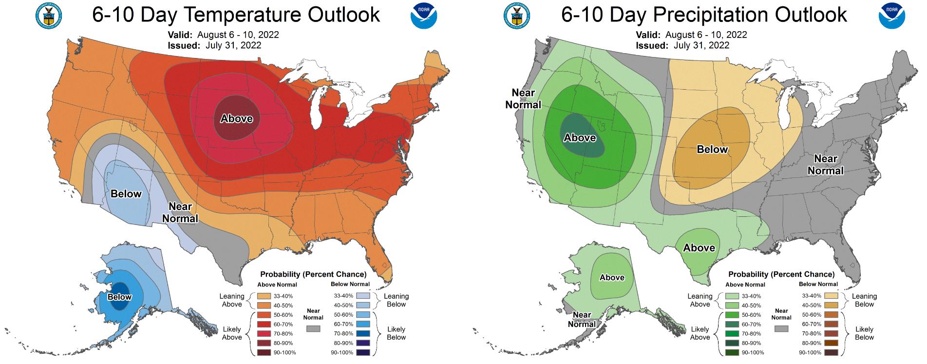
Secondly, the tropically-sourced moisture from the remnants of once-Hurricane Frank will come ashore in California on Thursday. After rotating clockwise around the high pressure center, this moisture should eventually reach the Front Range during the upcoming weekend leading to a rise in rainfall chances.

GFS moisture anomaly forecast animation from Wednesday into Saturday showing the remnants of Frank coming ashore.
At the moment, this jump in storm potential looks to happen on Saturday, but that could certainly change considering the lead time here.
Before the potentially wetter weekend ahead, Wednesday through Friday will see the relentless heat continue across the Denver Metro area. High temperatures will trend from near 90 degrees on Wednesday into the mid to upper 90s by Friday with just miniscule rainfall chances.
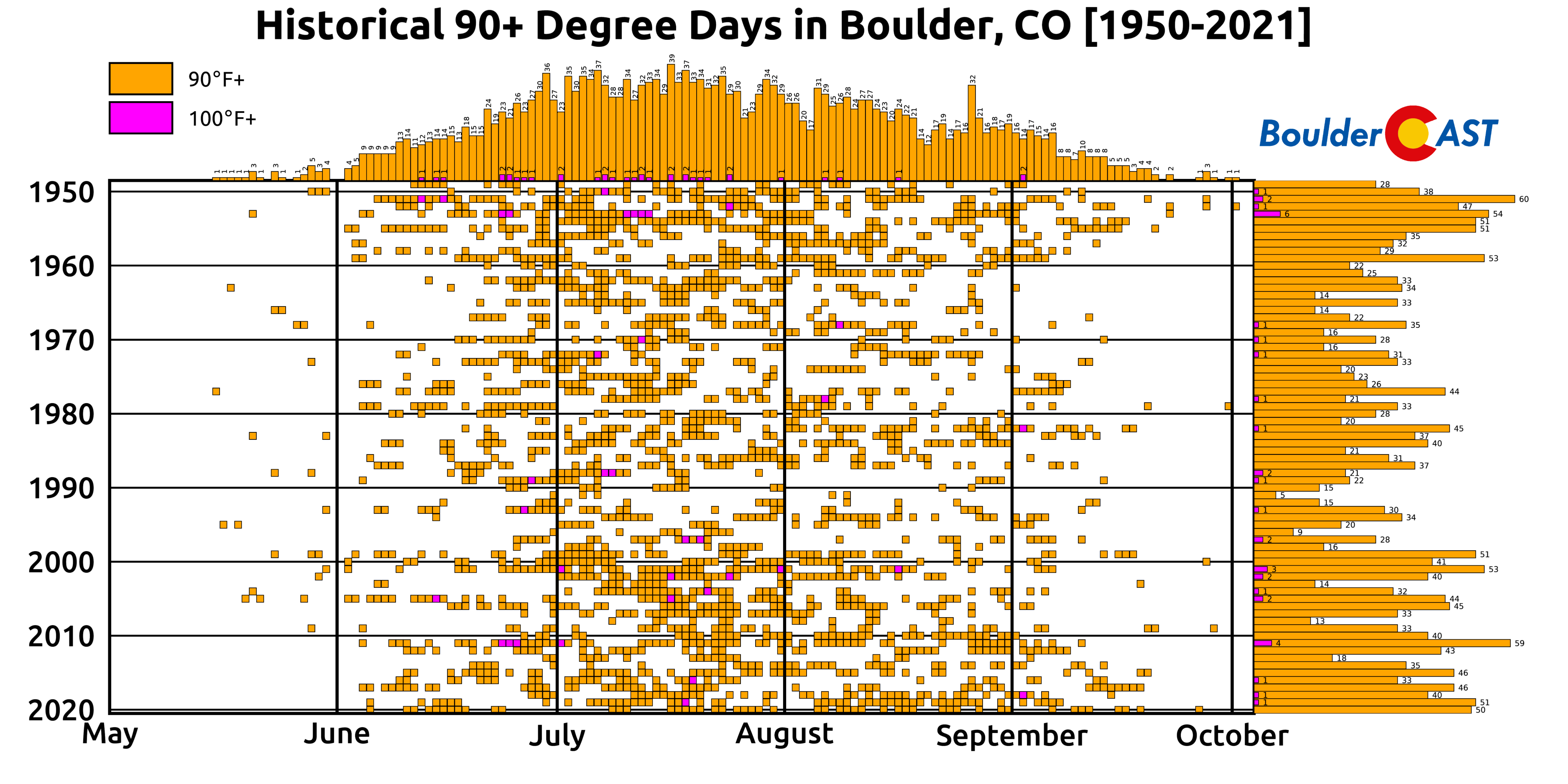
We do have some good news for those tired of the summer heat. With our transition to August, our average high temperature slowly starts to decline, a trend that lasts all the way into late December! Oh and we’re just five weeks away from our earliest first snowfall on record!

After August 1st, Boulder has only ever reached 100 degrees 5 times. On the contrary, before August 1st there have been 33 occurrences. So yes, the worst of the summer heat is likely behind us, but that’s not a guarantee of cooler weather. This week will certainly be hot with above average temperatures expected each and every day…
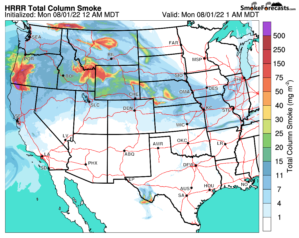
Finally, we want to draw your attention to the plethora of smoke engulfing the northwestern tier of the country right now. There are a slew of medium to large wildfires burning across the West, captained by the 52,000-acre (and 0% contained) McKinney Fire in far northern California which ignited late last week. The Front Range has been fairly lucky so far with most of the smoke bypassing our area to the north in the prevailing flow. This will change slightly this week as some of this smoke is expected to clip northeast Colorado on both Monday and Wednesday. Knock on wood, but so far substantial wildfires have remained outside our state’s borders this summer. Let’s keep it that way!
Stay up to date with Colorado weather and get notified of our latest forecasts and storm updates:
Forecast Specifics:
Monday: Partly cloudy and hot with isolated afternoon and evening thundershowers in the higher terrain. A few sprinkles may reach the Plains. Light smoke will be around from fires burning upstream. Highs in the middle 90s on the Plains with lower 80s in the Foothills.
Tuesday: Staying hot and partly cloudy. Scattered storms will be possible during the afternoon and evening, with some chance a few could linger into the overnight hours. Highs in the middle 90s on the Plains with upper 70s in the Foothills.
Wednesday: Mostly sunny and a little cooler. Some smoke will be around as well. Isolated storms will be possible, mainly across the higher elevations and western Denver Metro ara. Temperatures peak around 90 degrees on the Plains with middle 70s in the Foothills.
Thursday: Heating back up with mostly sunny skies and isolated late-day storms. The focus again will be across the higher terrain. Temperatures in the middle 90s on the Plains with lower 80s in the Foothills.
Friday: A mix of clouds and sun and hot. A few isolated storms possible. High temperatures soar into the mid to upper 90s on the Plains with lower to middle 80s in the Foothills.
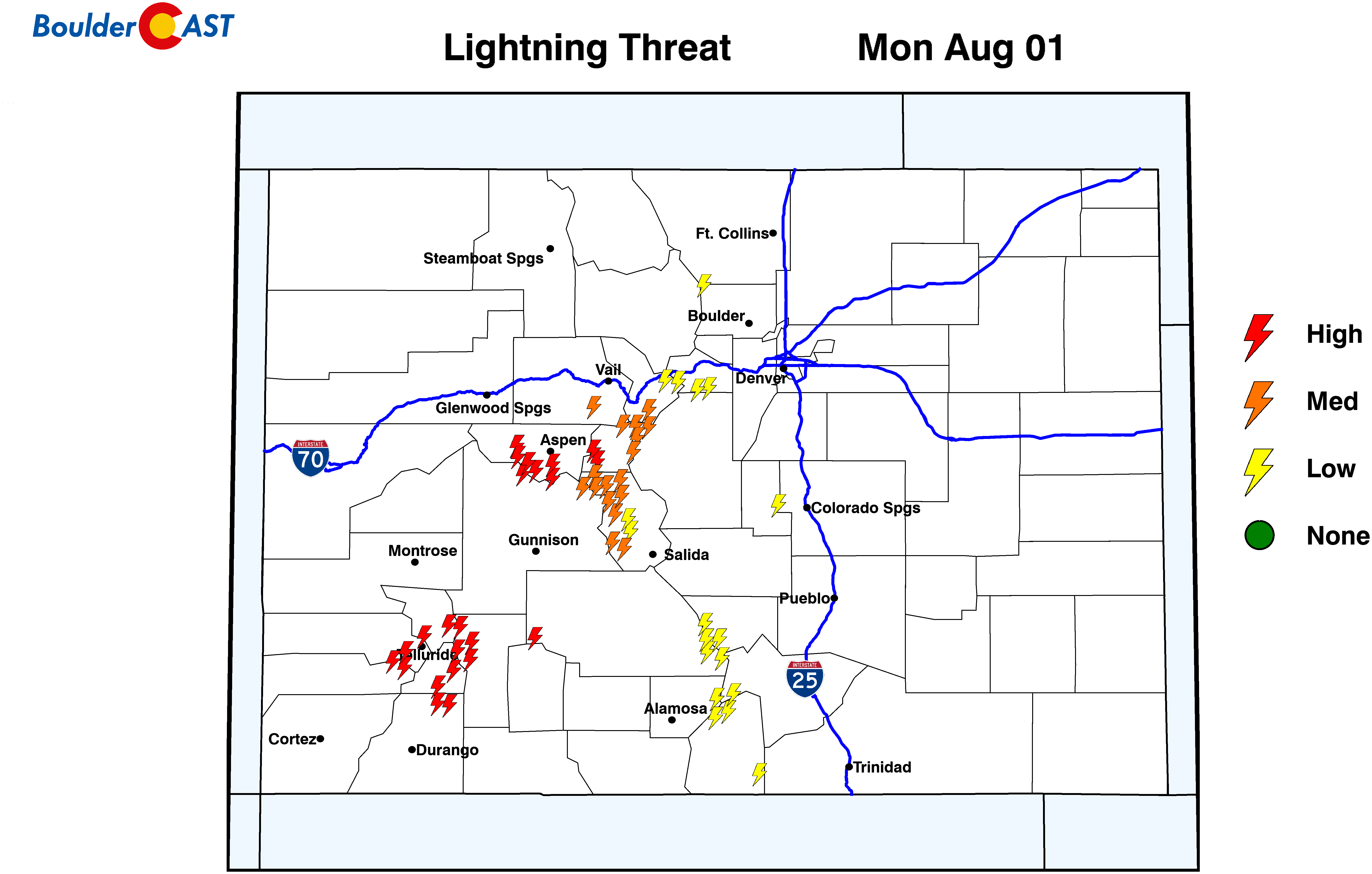
High Country: There will be a chance of storms each day over the High Country, with the best chances on Tuesday and Friday. The other days will see just isolated to widely scattered storms around. Temperatures will remain above normal through the week with fairly light winds. Still, dont underestimate the lightning potential each day if headed up into the Mountains — plan ahead!
Help support our team of Front Range weather bloggers by joining BoulderCAST Premium. We talk Boulder and Denver weather every single day. Sign up now to get access to our daily forecast discussions each morning, complete six-day skiing and hiking forecasts powered by machine learning, first-class access to all our Colorado-centric high-resolution weather graphics, bonus storm updates and much more! Or not, we just appreciate your readership!
Spread the word, share the BoulderCAST forecast!


You must be logged in to post a comment.