There has been a dramatic drop in visibility and air quality across Colorado as smoke from several large wildfires burning in California and Oregon moved in on Wednesday. We discuss the smoke’s path to get here, how many acres have burned so far in 2018, and the potential weather impacts wildfire smoke can have.
WHERE DID THE SMOKE COME FROM?
The massive conglomeration of smoke was clearly visible as NASA’s MODIS satellite passed overhead on Wednesday. The red dots below are active fires as classified by the satellite itself.

Source: NASA MODIS
Of course, GOES-East always provides a beautiful view as well:
Source: College of Dupage / NOAA GOES-16
More and more layers of mountains have been “disappearing” as a result….

Source: BoulderFlatironCam.com
The smoke found its way into Colorado by circulating clockwise around the area of high pressure centered in Arizona.

GFS 700 mb wind forecast for the western United States for Thursday afternoon.
This is by far the largest and thickest plume of smoke present across the western United States this year, with values exceeding 50 mg/m2 in the Metro area today.

Source: NOAA HRRR-Smoke model viewer
The resulting air quality forecast for Thursday is not great in Denver…an Air Quality Index (AQI) over 100, which is unsafe for “sensitive groups”. The roadway signs also tell us it is an “Ozone Action Day” and are insistent that we carpool and run all of our errands at once…

Source: The EPA (just kidding, they don’t exist anymore!)
At this point, there really is too much smoke present for it to clear out totally all that soon. We’ll probably be seeing varied amounts of smoke for the next week or so. The HRRR-Smoke model does forecast less smoky air moving into Colorado for Friday, though.
2018 WILDFIRE UPDATE
Did you know that our state currently has the second most actively burning “large” fires (12), just behind Alaska (15)? Many of our larger fires are closing in on 100% containment, however.

Source: US Forest Service
Most, but not all the big fires, are burning in areas with ongoing drought…

Source: United States Drought Monitor
Through August 1st, more than 4.8 million acres have burned across the United States, with around 400,000 acres in Colorado alone. The USA total is about 1 million acres above average for this time of year. You’ll also notice that 2018 is running BELOW average in total number of fires, but there sure has been some HUGE ones this year to make up for it!
| Wildfire Year-to-date statistics (USA) | ||
| 2018 (1/1/18 – 8/1/18) | Fires: 37,591 | Acres: 4,810,195 |
| 2017 (1/1/17 – 8/1/17) | Fires: 39,227 | Acres: 5,639,919 |
| 2016 (1/1/16 – 8/1/16) | Fires: 34,391 | Acres: 3,529,739 |
| 2015 (1/1/15 – 8/1/15) | Fires: 35,782 | Acres: 5,650,307 |
| 2014 (1/1/14 – 8/1/14) | Fires: 33,720 | Acres: 1,651,320 |
| 2013 (1/1/13 – 8/1/13) | Fires: 28,016 | Acres: 2,336,185 |
| 2012 (1/1/12 – 8/1/12) | Fires: 37,576 | Acres: 4,088,349 |
| 2011 (1/1/11 – 8/1/11) | Fires: 46,469 | Acres: 6,104,883 |
| 2010 (1/1/10 – 8/1/10) | Fires: 37,474 | Acres: 2,008,621 |
| 2009 (1/1/09 – 8/1/09) | Fires: 57,072 | Acres: 3,647,431 |
| 2008 (1/1/08 – 8/1/08) | Fires: 57,072 | Acres: 3,612,544 |
| 10-year average Year-to-Date | ||
| 2008-2017 | Fires: 40,079 | Acres: 3,800,416 |
HOW DOES SMOKE IMPACT SUMMERTIME RAINFALL?
It shouldn’t be a surprise that the presence of smoke in the atmosphere can impact weather…In general, smoke tends to suppress rainfall, and it does so in more than one way.
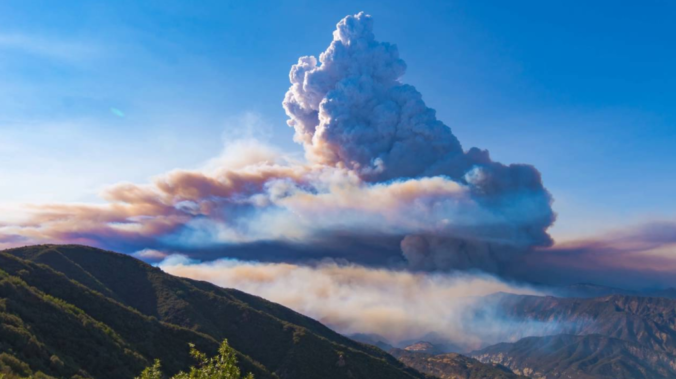
The thicker the smoke gets, the more solar radiation that is reflected, scattered and absorbed. Thus, less of that sunlight reaches the ground. During the summer time, solar heating is a key factor in producing cumulus clouds and thunderstorms, especially for Colorado. Thick smoke can behave just like a layer of stratus clouds. The decrease in solar heating caused by smoke can suppress convection and storms. Our friend Josh Aikins noticed exactly this happening this past Sunday when a near-linear plume of smoke advected into Colorado from northern California (see below). Notice the lack of cumulus clouds directly beneath the smoke. However, just north and just south of the smoke, clouds and thunderstorms were happily forming without issue. This indicates the smoke was probably blocking enough sunlight to suppress deeper convection in the atmosphere. The situation is rarely this black-and-white, though, as other atmospheric factors can drive convection even with thick smoke in place.

GOES-East satellite visible image from Sunday July 29 in the afternoon
Another slightly more complex way that smoke can reduce rainfall is through altering the particle size distribution (PSD) of droplets within the clouds themselves. In order to explain this further, let’s review a few key factors for cloud formation and then how precipitation forms from existing clouds….
Cloud formation process: In order for clouds to form, water vapor must first condense onto tiny particles in the atmosphere known as cloud condensation nuclei (CCN). These particles come in many shapes and sizes, but all originate from the Earth’s surface. Typical CCNs include sea-salt from the ocean, dust, soot and smoke from fires, and anthropocentric pollutants from industry and cars.
Precipitation formation process: A key factor in the process that clouds undergo to produce precipitation is maintaining a wide PSD. That is, many different sizes of CCN and cloud droplets, such that cloud droplets fall at different speeds and are able to collide with one another. Eventually after enough collisions, the droplets are large enough to fall completely out of the cloud and are considered raindrops. This process is called collisional coalescence and is depicted in the simplified diagram below.
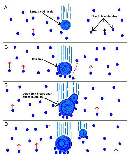
Contrary to what common sense might be telling you, introducing a plethora of smoke CCN to the atmosphere from wildfires is actually NOT good for rainfall. Smoke particles tend to be one of the smallest CCN. In clouds riddled with wildfire smoke, yes there will be a lot of cloud droplets, but they will all be very small and very similar in size to one another. This size similarity means gravity is affecting most of them in a similar manner, and they all fall downward at about the same speed. Remember that for raindrops to form, cloud droplets need to be greatly varied in size to support collisions. Smoke-filled clouds have reduced collisions and thus reduced rainfall potential.

Wildfire smoke’s impact on precipitation remains an active area of research. In general, there is reduced rainfall in the region nearby to the fires due to the reasons described above. However, because that moisture remains in the cloud and doesn’t fall out as rain initially, it can potentially survive longer in the atmosphere and eventually lead to more rainfall in regions downstream.
On a similar note, you may have also heard of cloud seeding. This is a technique where we (humans) inject specific CCN (usually big ones) into clouds with hopes of altering the PSD enough to cause more collisions and more overall rainfall. Results from cloud seeding have been mixed, but it’s largely due to the scope of the concept. Obtaining measurable changes in precipitation is one thing. Linking those changes specifically to the cloud seeding is another. However, based on theory alone, cloud seeding is indeed a way to get precipitation to happen on-demand. It could eventually be a method employed by states or rich agricultural companies to combat drought. This is a form of weather modification and, at the present, is a controversial topic.
Spread the word, share this post!
.


You must be logged in to post a comment.