The last month has been very dry across the Denver Metro area with the progress we’ve made this year towards eradicating the drought starting to reverse. Wind and high fire danger have been rampant of late and that isn’t going to change this week, though it won’t be nearly as bad as recent times. Temperatures will be up and down through the days ahead, but prospects for any precipitation remain woefully slim.
This week’s highlights include:
- Quiet and seasonal Monday with minimal winds as a shortwave ridge moves through
- Warm and gusty Tuesday with elevated fire danger
- A cold front clips the area Tuesday night bringing a few inches of Mountain snow — dry with a slight cooldown for the Plains
- Warming right back up on Thursday to near 80 degrees
- Watching a storm moving across the northern Rockies late Friday into Saturday — most likely tracks too far north and brings just wind to our area and minimal precipitation

DISCLAIMER: This weekly outlook forecast is created Monday morning and covers the entire upcoming week. Accuracy will decrease as the week progresses as this post is NOT updated. To receive daily updated forecasts from our team, among many other perks, subscribe to BoulderCAST Premium.

The storm track stays too far north
April thus far has been defined by strong winds and all-to-frequent wildfires, not by the normal rain showers or late-season snow. Boulder has only had measurable precipitation one day this month amounting to just 0.12″ so far. Denver has only seen 0.01″! This dry stretch of weather, which really began in mid-March, has nearly eradicated the 2022 moisture surplus previously manufactured in January and February.
Sad but true: In the last three weeks, Boulder County has had more wildfires (3+) than Denver has had hundredths of an inch of precipitation (1). #COwx
— BoulderCAST Weather (@BoulderCAST) April 18, 2022
Unfortunately, we’re not seeing any real signs of change in the forecast this week which begins on the quiet side across the Front Range with a shortwave ridge moving across the region. Highs on Monday will be in the middle 60s with sunny skies. We get a break from the strong winds and high fire danger, at least for one day…
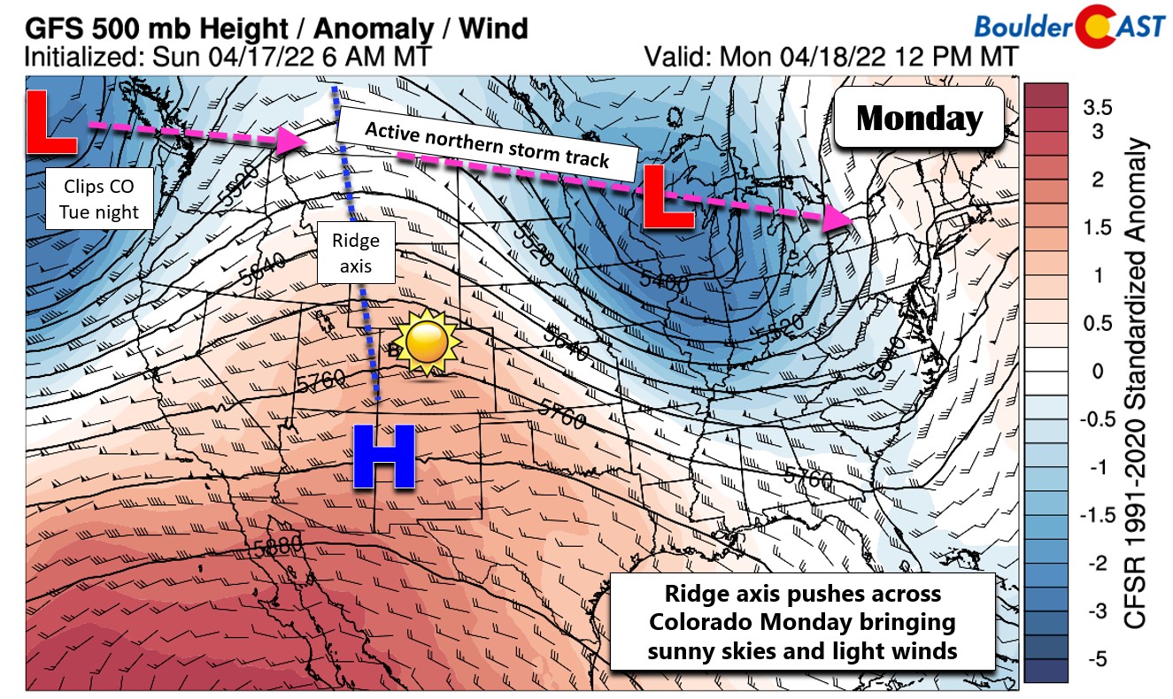
That ridge kicks east on Tuesday with southwest downslope flow taking over across Colorado. This shift is tied to a new storm moving across the northern Rockies — part of an active far northern storm track that will leave our area dry and windy this week, too.
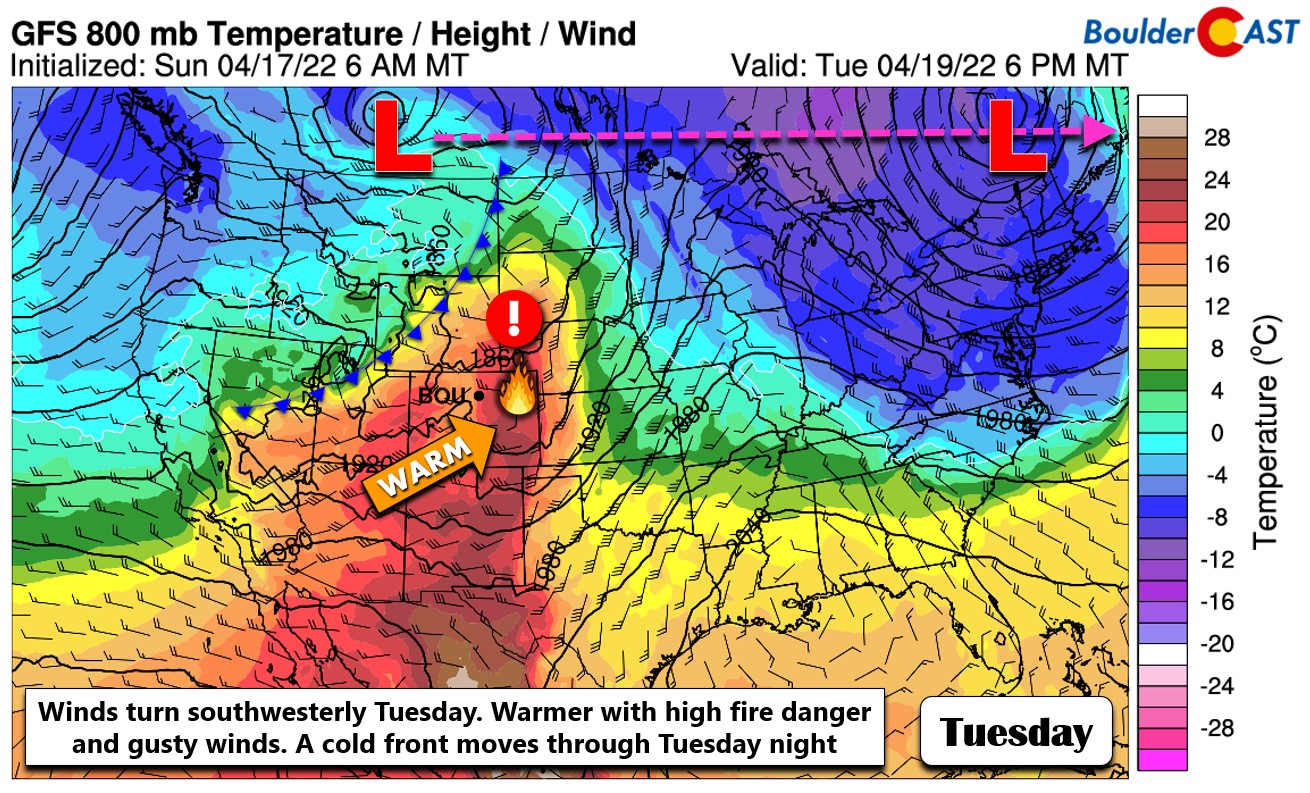
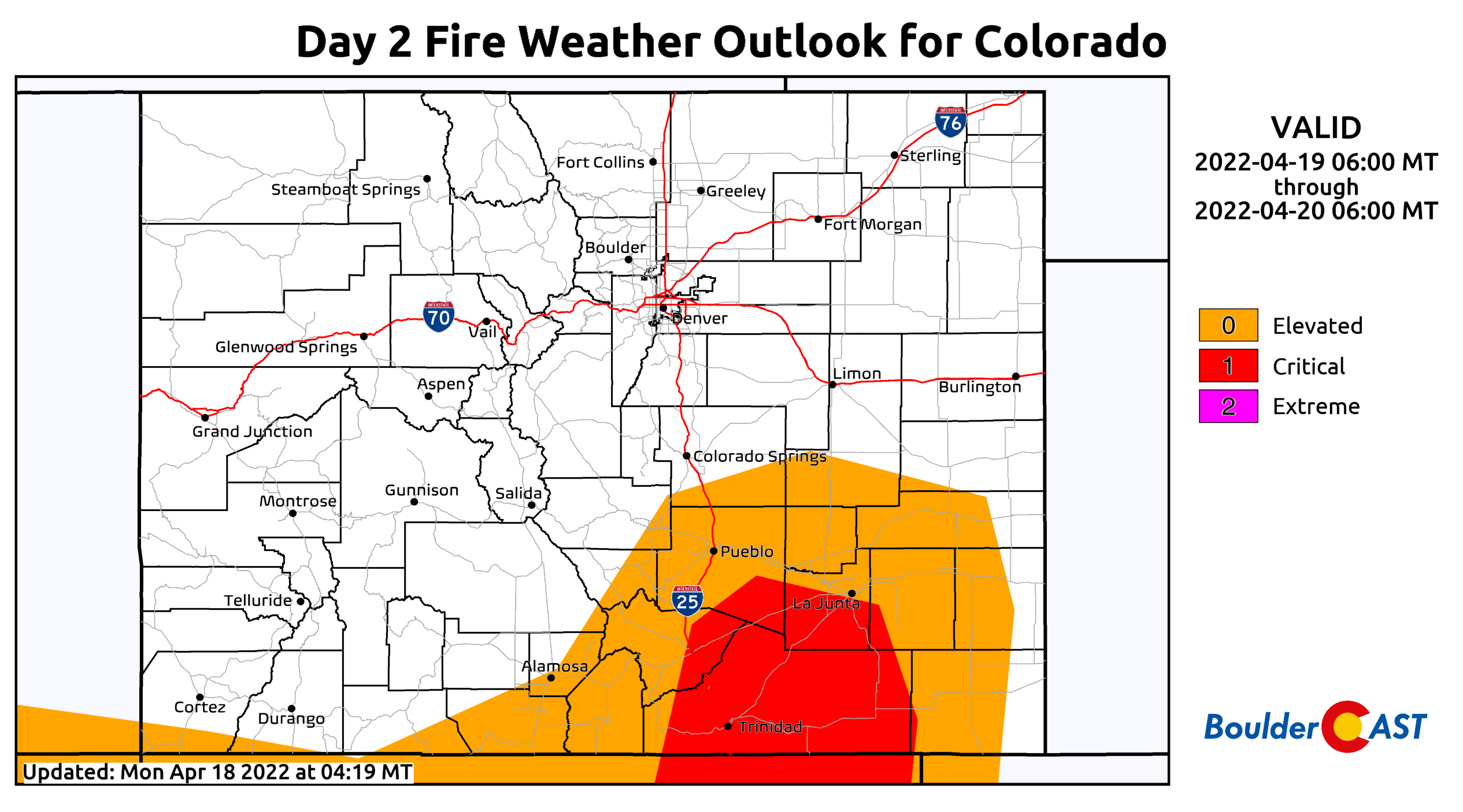
The gusty afternoon winds of 20+ MPH return alongside dry air for us on Tuesday. This will spell out another day of elevated fire conditions across the Denver Metro area as high temperatures climb into the middle to upper 70s.
The cold front associated with the low pressure tracking along the Canadian border will move through our area Tuesday night. Moisture won’t make it over the Continental Divide, but temperatures will fall a few degrees behind the front on Wednesday back into the upper 60s with plenty of sunshine. The northern Mountains could see a few inches of snow as this system skirts through.

Snowfall totals through Wednesday morning
Another shortwave ridge moves through on Thursday with temperatures bumping up accordingly into the upper 70s.
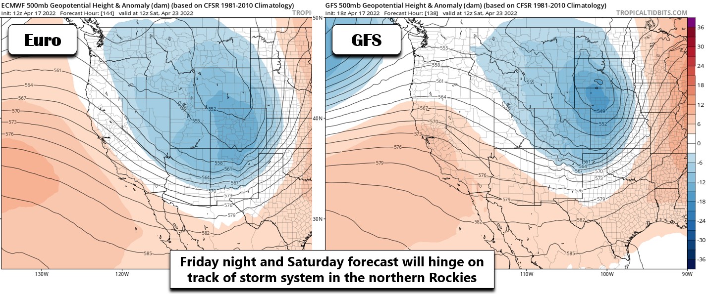
It’s not until very late in the week and into the weekend that we finally see a storm tracking a little further south. There is quite a bit of model variation on the track of a low pressure pushing across the central Rockies Friday night into Saturday — but to be blunt, nothing looks all the promising for us at the moment. The GFS model is further north with mainly just winds for us, while the Euro is somewhat further south and more favorable for some precipitation in the Denver area (possibly even some snow). Overall this pattern has a slightly better chance of leading to some precipitation, but more than likely it will mainly be a wind producer for eastern Colorado.
We’ll be tracking this storm through the week and will update you if things change. Temperatures on Friday will be slightly cooler in the 70s with southwest winds starting to kick back up raising fire concerns once again.
Forecast Specifics:
Monday: Sunny with light winds and seasonal. High temperatures in the middle 60s for the Plains with lower 50s in the Foothills.
Tuesday: Warm, dry and windy with gusts of 20-25 MPH across the lower elevations creating elevated fire conditions. Red Flag Warnings are likely south of Denver. Highs in the upper 70s on the Plains and middle 60s in the Foothills.
Wednesday: Partly cloudy and slightly cooler. Temperatures top out around 70 degrees on the Plains with middle 50s in the Foothills.
Thursday: Warmer and breezy with a mix of clouds and sun. Temperatures reach the upper 70s on the Plains with middle 60s in the Foothills.
Friday: Mild and breezy with increasing wave clouds ahead of an approaching storm system. Fire danger will likely be elevated if not critical. Highs in the 70s on the Plains with 60s in the Foothills.
Mountains: Two systems will impact the Mountains this week. The first moves through Tuesday night into Wednesday morning and will bring a few inches of snow to only the Mountains north of Interstate 70 (1-4″). The second system arrives Friday into Saturday bringing a more widespread wave of snowfall to most high mountain ranges.
Help support our team of Front Range weather bloggers by joining BoulderCAST Premium. We talk Boulder and Denver weather every single day. Sign up now to get access to our daily forecast discussions each morning, complete six-day skiing and hiking forecasts powered by machine learning, first-class access to all our Colorado-centric high-resolution weather graphics, bonus storm updates and much more! Or not, we just appreciate your readership!
Spread the word, share the BoulderCAST forecast!


You must be logged in to post a comment.