The potent winter storm is moving into Colorado as we speak. We’ve got just a quick update for you this morning as models remain shockingly consistent placing the bullseye of heavy snow directly on the Denver Metro area. We discuss the latest timing on the heaviest snow bands, expected travel impacts, and provide our final prediction on snowfall amounts. Spoiler alert: they have gone up a tad!

Go Premium, get all the perks.
Daily Forecast Updates
Get our daily forecast discussion every morning delivered to your inbox.
All Our Model Data
Access to all our Colorado-centric high-resolution weather model graphics. Seriously — every one!
Ski & Hiking Forecasts
6-day forecasts for all the Colorado ski resorts, plus more than 120 hiking trails, including every 14er.
Smoke Forecasts
Wildfire smoke concentration predictions up to 72 hours into the future.
Exclusive Content
Weekend outlooks every Thursday, bonus storm updates, historical data and much more!
No Advertisements
Enjoy ad-free viewing on the entire site.
When our first snow is also a BIG snow…
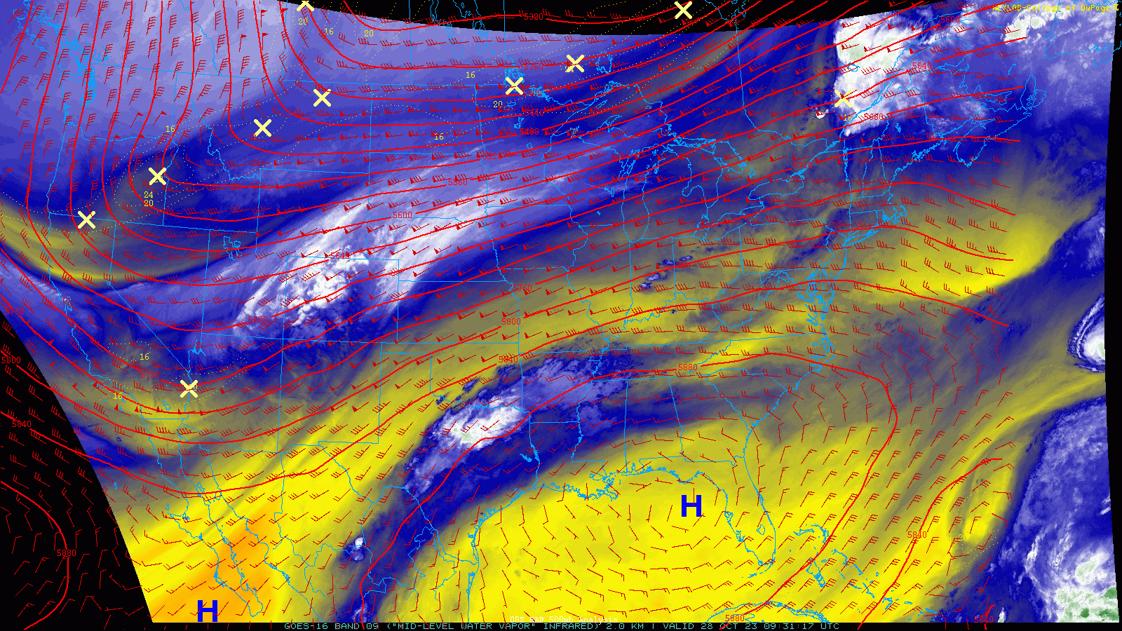
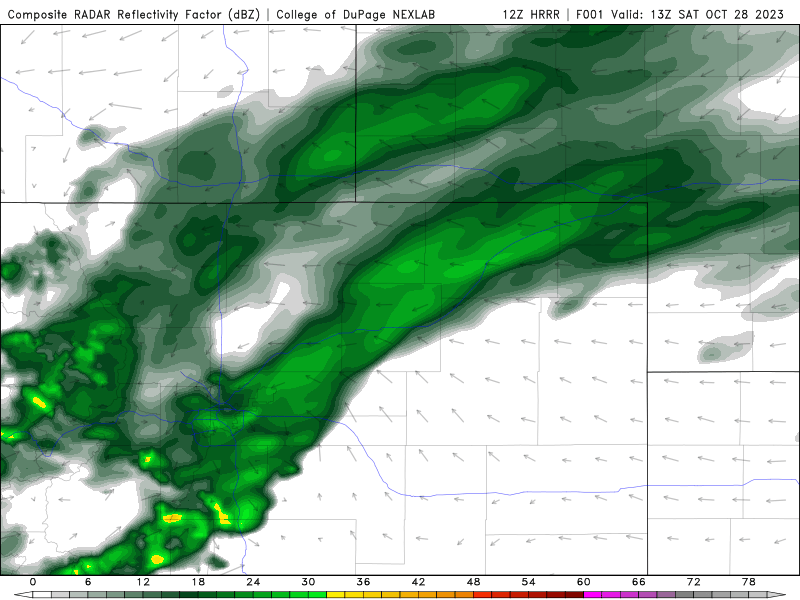
We’ve got just a very quick “confirmation” type of update for you this morning as the expected winter storm system begins to tighten its grasp on Colorado. For a full breakdown of the incoming atmospheric setup fueling our first snow, please read our in-depth discussion from yesterday. As of Saturday morning, the positively tilted trough axis sits to the northwest and continues to sag southward toward the Front Range. Water vapor imagery below shows a plethora of moisture and clouds streaming in from the southwest ahead of the trough.
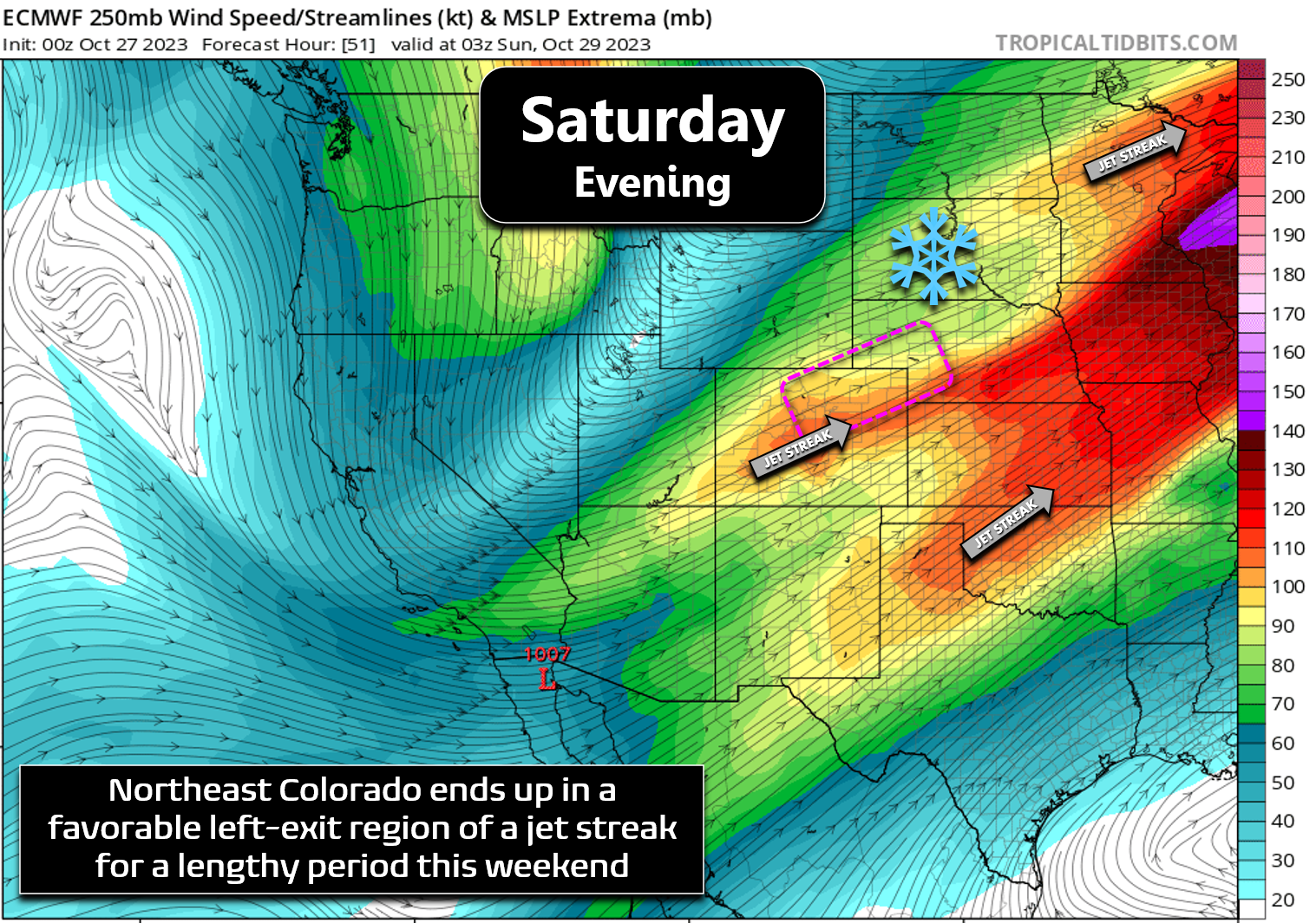
Most of the action is currently across western Colorado and parts of Wyoming. This will change quickly through by afternoon as the best lift sags into the Front Range and meets up with a piece of the jet stream coming in from the southwest. The jet stream feature is really the primary forcing mechanism for this weekend’s winter storm as it is responsible for the long narrow bands of heavy snow that will quickly turn our area into a winter wonderland! Yes, there will be a tad of upslope pushing into the terrain, but that will only be a minor player this time around. Any terrain enhancement that does occur will mainly be due to the colder temperatures up there which will support fluffier snow ratios.
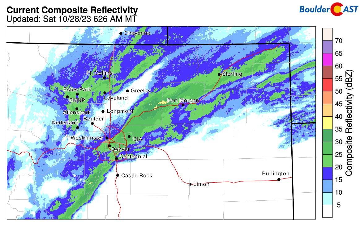
These winter storms which rely so heavily on jet stream features are never an easy forecast for us and rarely play out as exactly expected here. They almost always produce way too much or too little snow — we aren’t exaggerating when we say how challenging these events can be to predict perfectly. However, over the last several days, we have observed strong weather model support across the board for the development of heavy snow bands the rest of Saturday into Saturday night and the models have not wavered from this at all. A couple of said heavy snow bands have already setup across the Front Range in the early morning hours on Saturday, a sign of things to come the rest of day and tonight. These bands likely already produced light accumulations in parts of Denver, Aurora, and out near DIA — the first of many to come to get their first snow!
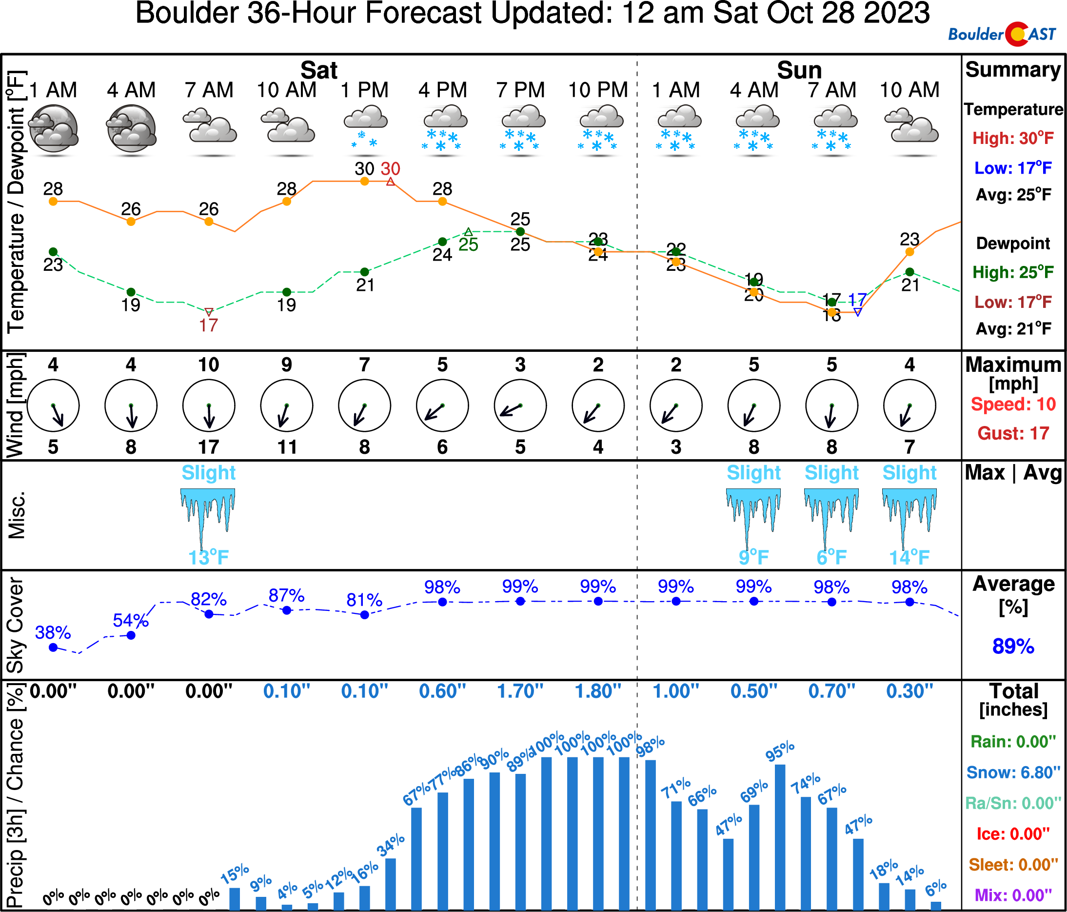
The short-range HRRR simulated radar animation below shows a long break in the action through the day as the first jet feature scoots off to the east. Much of Saturday will be overcast, cold and drab with not much snow activity for many of us. However, the primary jet streak and main storm system will arrive in tandem Saturday afternoon seeding the increase in heavy snow bands once again. Saturday afternoon and evening will be particularly brutal across our area with slow-moving snow bands meandering about while putting down extremely heavy snow. Snowfall rates of 1 to 2″ per hour will be common during the evening hours which will make for difficult travel as the sun goes down and roads become snow-covered. Travel impacts could happen even earlier in the afternoon if a band hits your location. The more widespread travel concerns come after sunset, though.
There’s only good news today if you love snow: just about every global and regional weather model puts the Denver Metro area in the absolute “sweet spot” for this storm with those aforementioned heavy snow bands basically just sitting over the area for a solid 12 to 18 hour period. Check out all the model snowfall forecast below. We’ve annotated some lines showing the orientation of the snow bands.
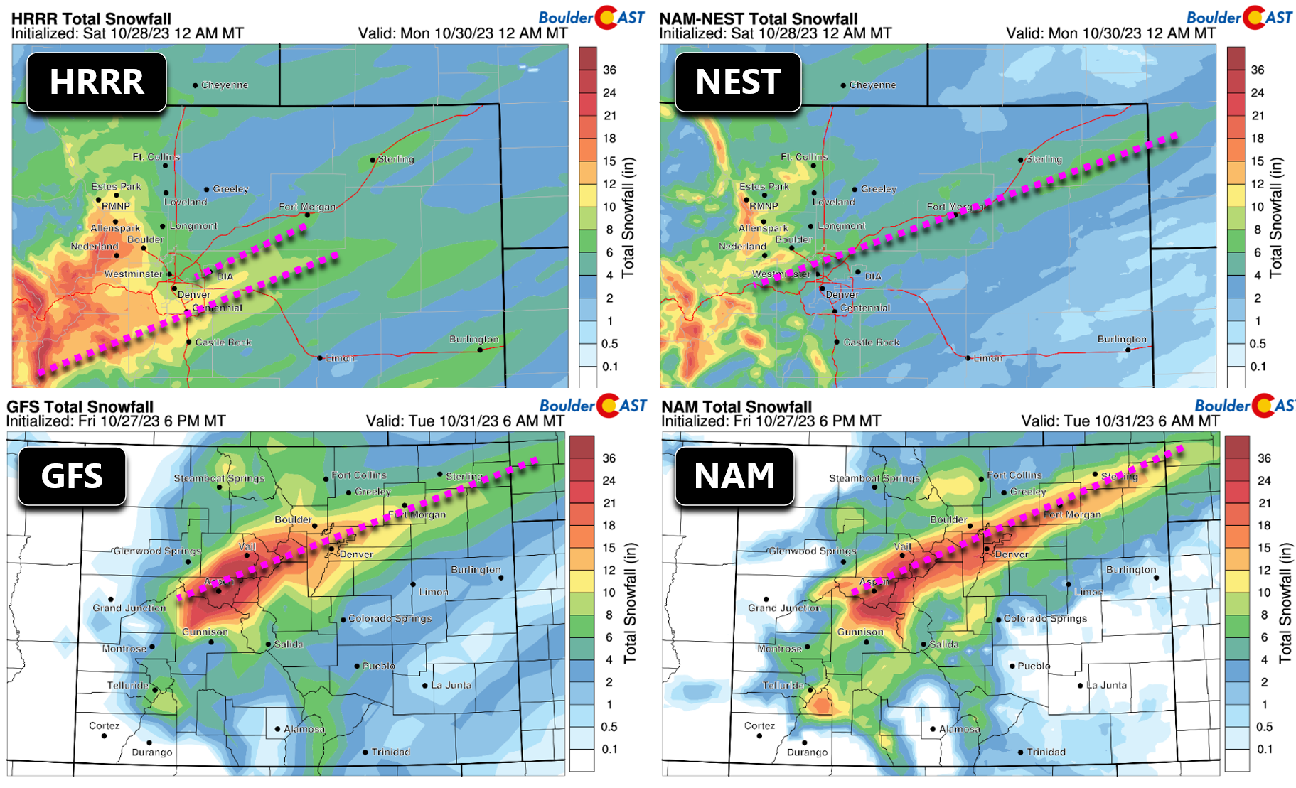
All things considered, we are bumping up our snowfall totals just a tad across the area as models continue to trend slightly upward and target precisely the Denver Metro area for the heaviest swath of snow accumulation this weekend. Our updated snowfall forecast map for the event is shown below. We now include most of the Denver Metro area, Boulder and the Foothills in a 6-12″ zone. Lesser totals of 3-8″ are still expected further north around Longmont/Fort Collins and west of the Continental Divide.
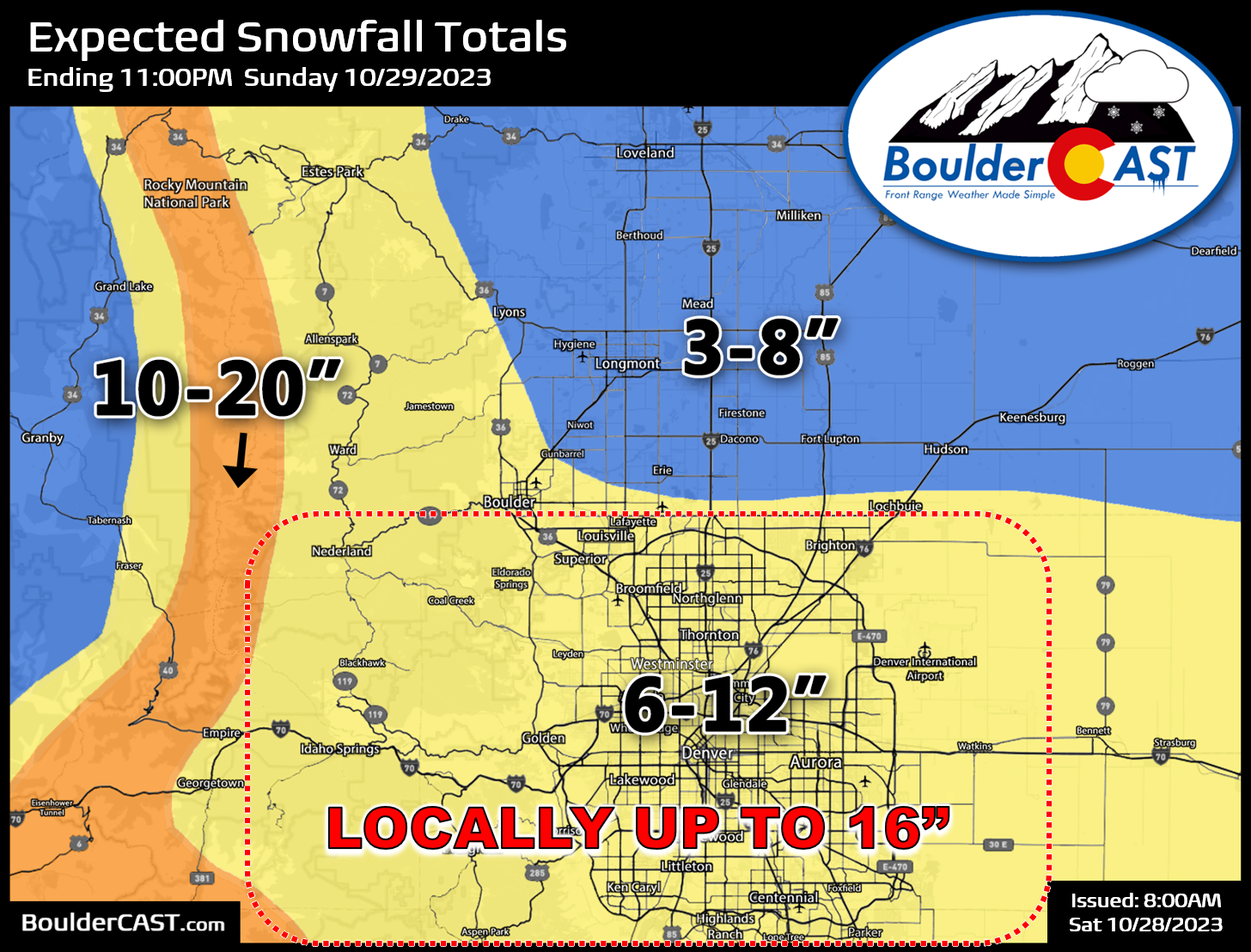
We can’t stress enough that even though things are looking very good on paper with this storm, jet-forced bands are a beast to forecast! As such, we’ve also outlined above an area in red where locally up to 16″ of snow may occur. Totals that large should be rare overall in the Metro but given there will be slow-moving bands which can put down 2″ per hour at their core, we felt the need to include that “upsell”, if you will, for this event. We fully expect there will be some underperforming areas during this event as well. Most of the accumulation will be happening underneath scattered heavy snow bands, with only very light snow elsewhere. Locations which happen to get really unlucky and mostly miss out on the bands will be left with a busted forecast. We’re already mentally preparing to see your boom/bust-related comments coming in Sunday morning!
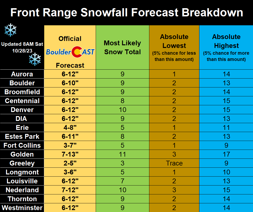
The table below breaks down our forecast further for some specific cities across the area, including our official forecast ranges, subjective most likely snow total, and also some scary boom and bust scenarios.
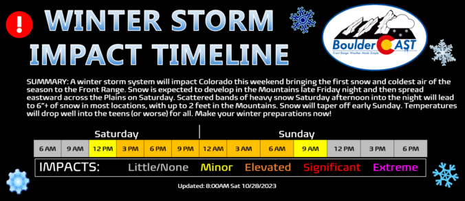
As for impacts, things will begin to go south Saturday afternoon with difficult travel lingering all the way in to Sunday morning. Travel is not recommended of course, but no one ever takes that advice — so yeah, might as well get an early start and proceed to I-25 now!

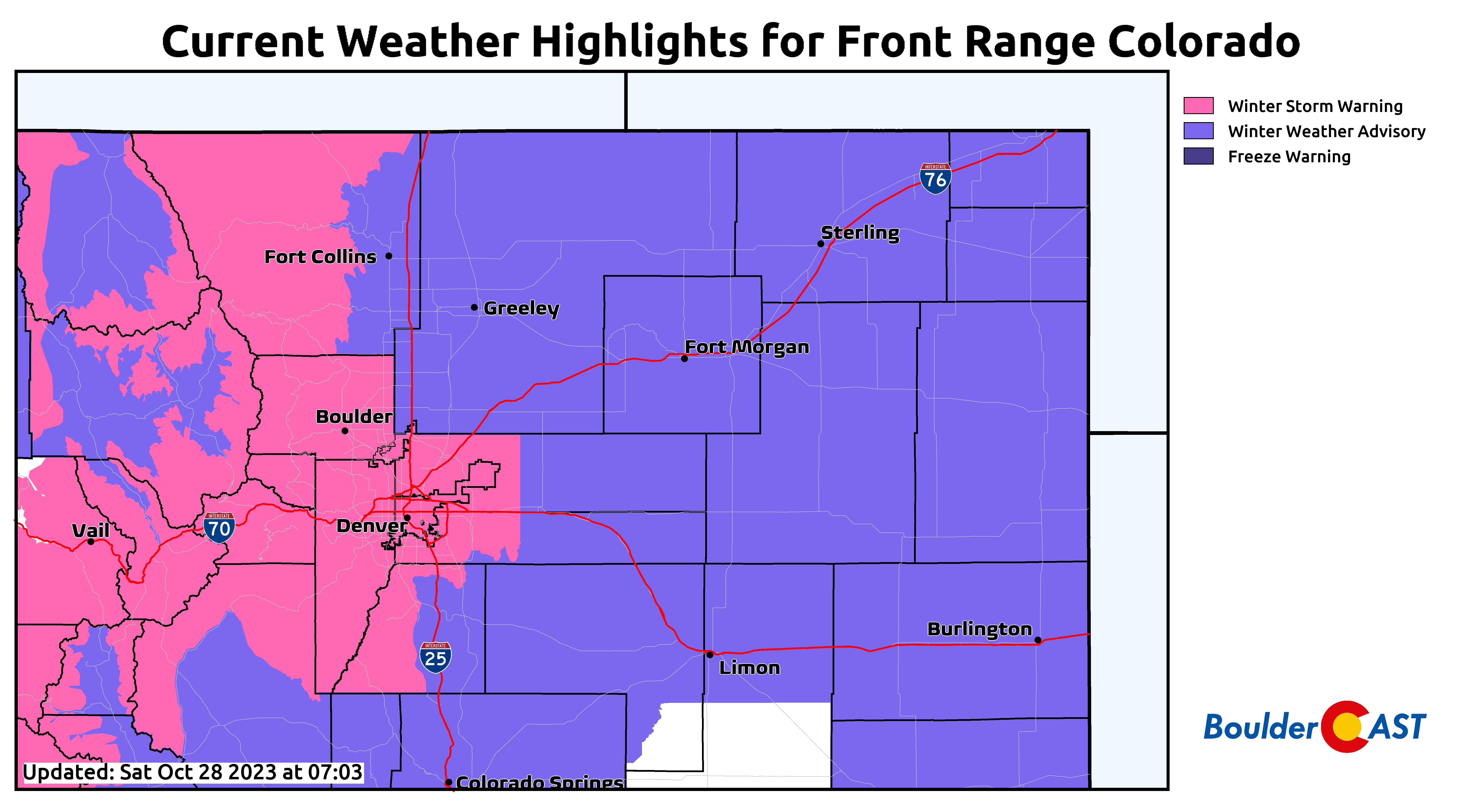
A Winter Storm Warning is in effect through noon Sunday for the heart of the Metro area, Foothills and Mountains. Basically everywhere else on all sides is covered under a Winter Weather Advisory. Almost no one in Colorado will escape winter’s grasp this weekend!
That’s all we have for now. Expect the usual amount of first snow shenanigans on the roadways, with things likely landing even crazier than usual due to it also be a significant snow event as well. Be safe out there! We’ll continue to monitor the evolving storm and pass along any updates on social media as needed so be sure to stay subscribed. Enjoy the snow and colder weather — so many of you have been asking for it!
Get BoulderCAST updates delivered to your inbox:
First Snowfall Contest: May the best forecaster win!
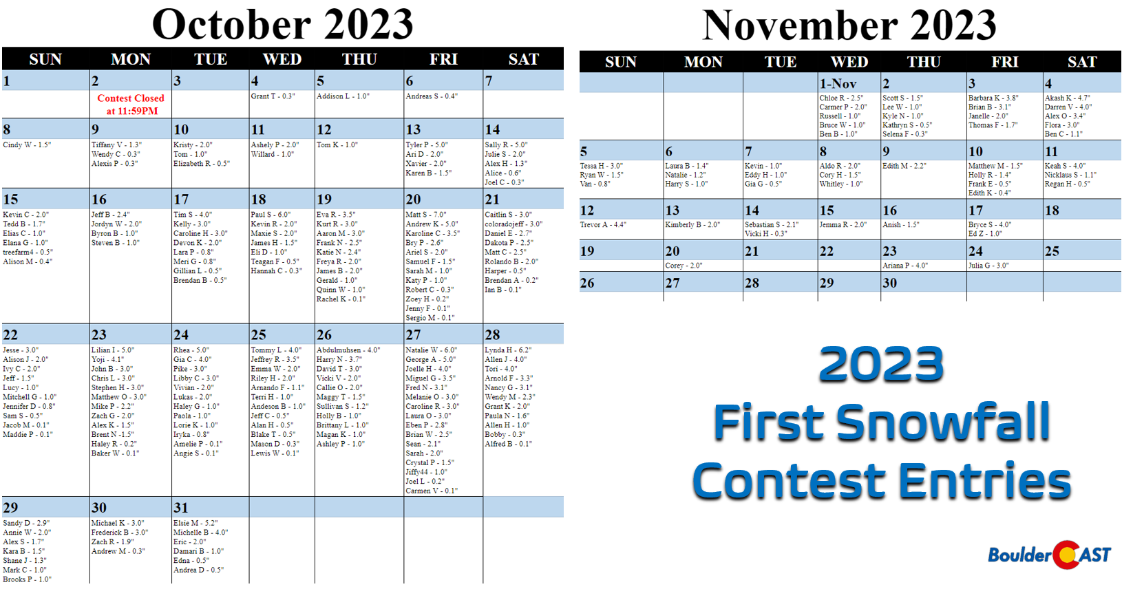
n the announcement post for this contest, we offered a little insight by providing a few of Boulder’s “first snow” statistics. More than 250 of you came up with “educated” guesses for the timing and amount of Boulder’s first snow of the 2023-24 winter season. All of the entries are contained in the calendar view below (click to enlarge):
SUMMARY OF SCORING:
Those who come closest to the actual date of Boulder’s first MEASURABLE SNOW (defined as snowfall at or above 0.1″) win! For verification, we’ll go off the official Boulder climate station located at the NIST building in south Boulder. Only the first calendar date of snow will be used (i.e. if the first snow event spans two days, only the amount of the first day will count). In the event that multiple participants select the same date, the tie-breaker of snowfall amount will be used.
SUMMARY OF PRIZES:
The prizes for the contest are as follows:
- 1st place: 12-month Premium subscription + $30 Amazon Gift Card
- 2nd place: 6-month Premium subscription + $10 Amazon Gift Card
- Anyone who guesses within 1 day OR 0.1″ correct: 2-month Premium subscription
- All other entries: Virtual “pat on the back”
2023 First Snowfall Contest prizes and recognition will be awarded in the days following our first dumping of snow which looks like it will either be October 28th or 29th, based on the latest forecast!
Enjoy our content? Help us out and give it a share:


You must be logged in to post a comment.