
A weak trough moved across Colorado on the evening of March 21st producing light to moderate snowfall across the area. Southern portions of the Denver Metro area were hit hardest due to a lingering band of heavier snow along a frontal boundary. Let’s take a look at the totals.
Category: Winter Weather (Page 71 of 139)
These posts contain some discussion of the white stuff, whether it be mountain snow pack or a Front Range snowstorm.

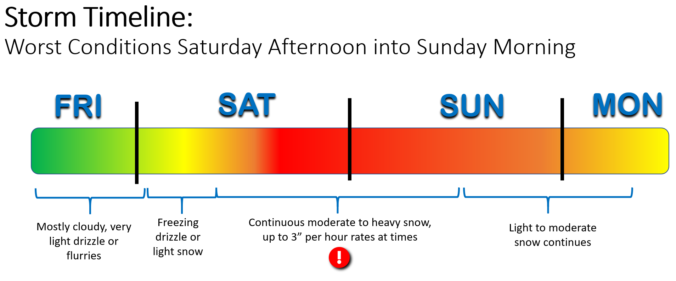
Happy first day of spring, everyone! Alright, now that we got that out of the way….let’s talk about the winter weather that is headed to the Front Range Sunday evening into Monday. A relatively quick moving but vigorous storm system will slide across the Rockies bringing more wet snow to the area. Let’s take a look at the timing and projected snow totals.
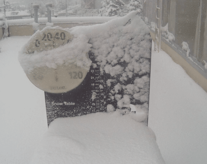
There is so much to unpack with this storm, from the moment it caught our eye a week in advance until the last snowflakes were flying, it was one-of-a-kind snowstorm and a true Front Range weather experience. We discuss the forecasting challenges leading up to the event, why many folks lost patience with this storm, and the massive snow totals the system eventually dumped across the Denver Metro area.


After the big winter snow storm over the weekend, the atmosphere takes a much needed breather for most of the coming work week. We are watching another chance of snow Tuesday but amounts will be light at best. More seasonal temperatures arrive by week’s end.
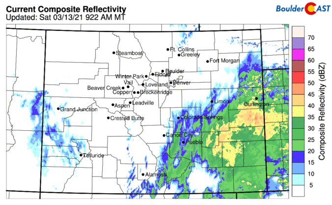
We provide a quick update on the situation this morning as wet snow continues to fall across the Front Range. While the storm has been underwhelming to some, we’ve still got nearly 24 hours of snowstorm left and a clear pathway to reach the lower bounds of our original snowfall prediction. Let’s run through the latest.
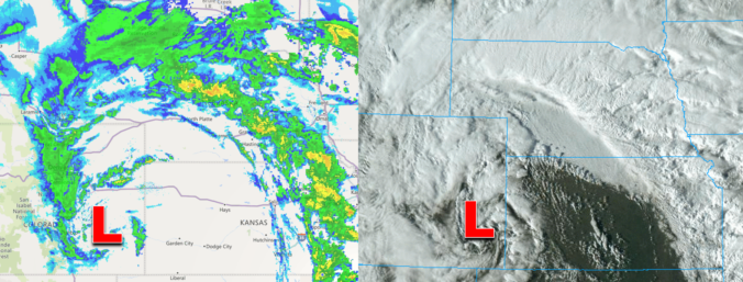
We provide a quick update on the situation this morning as Mother Nature is about to unleash on the Front Range! The potential for a bust has decreased and snowfall amounts have trended up overnight in the models. Let’s run through the latest.
The winter storm we’ve been tracking all week long is finally bearing down on Front Range Colorado and forecast confidence is not as high as we’d like this late in the game. We discuss the latest developments, including multiple pathways for a bust east of Interstate 25, and provide our latest snowfall forecast map.

Live View of Boulder

Current Conditions

Live Radar

Recent Premium Posts

BoulderCAST Daily – Wed 06/03/26 | Scattered P.M. storms again as moisture peaks for the week
🌬️ Weak westerly flow aloft today with no major synoptic features nearby; only …
BoulderCAST Daily – Tue 06/02/26 | Storms Reload This Afternoon, But With Noticeably Less Bite
❄️ Monday delivered lots of hail to northeast Colorado, with one supercell tracking …
BoulderCAST Daily – Sun 05/31/26 | Dry and warm today but rain chances increase this week
🌦️ Overall dry and warm Sunday, though cannot rule out a very widely …
3-Day Forecast

Trending Content

© 2026 Front Range Weather, LLC