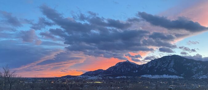
A bitter cold Arctic front blasted into the Front Range over the weekend bringing a quick change in our weather including record cold sub-zero temperatures and persistent light snow. The Arctic airmass remains entrenched for our Monday with more snow in the forecast, but things turn quiet and sunny rather quickly in the days to follow. Temperatures will slowly moderate the rest of the week so keep those shorts and t-shirts handy — we should get back near 50 degrees by the end of the week!
Category: Winter Weather (Page 48 of 139)
These posts contain some discussion of the white stuff, whether it be mountain snow pack or a Front Range snowstorm.
Unseasonably cold temperatures will be in place throughout the week ahead with little hope for any warmer weather in the near-term across Front Range Colorado. A southern-track storm system will bring light snow totals to the Front Range for our Monday. The chance of snow will returns Tuesday into early Thursday as northerly mid-level flow sends ripples of energy to combine with weak surface upslope. Temperatures may finally get out of the 30s by week’s end, but just barely!
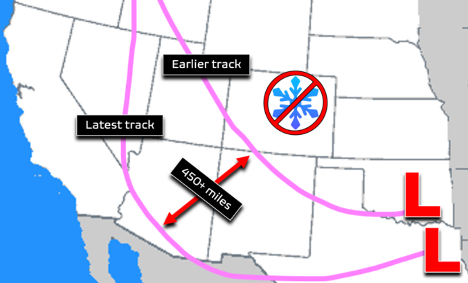
The chance of substantial snow in the Front Range Sunday night into Monday has largely vanished into thin air. We discuss why this happened and the now lighter potential snowfall totals to begin the work week.

There was a lot of complaining this week about the poor snow forecast, but it actually turned out pretty okay — not amazing, but definitely okay. Let’s take a quick look at the totals from across the area for what was a rather impressive winter storm by January standards. We also peek ahead to the cold and snowy stretch of weather to come.
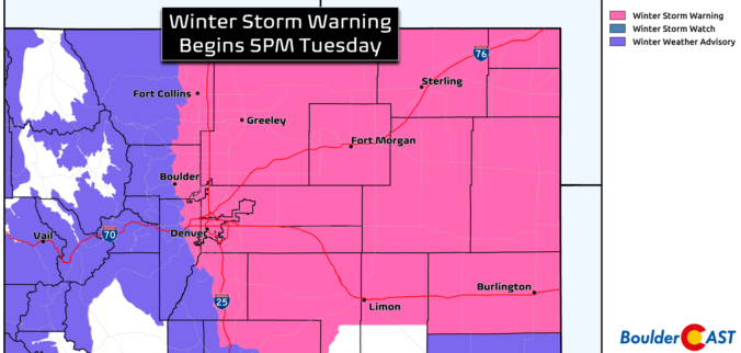
Widespread heavy snow is on the way for the entire Front Range Tuesday evening into Wednesday afternoon. A few subtle changes in the forecast have led to us increasing snowfall amounts a tad across the region. Read on for our latest detailed forecast discussion, newly amended snowfall forecast map, updated storm timeline, and more!
A major winter storm set to impact the Front Range Tuesday night through Wednesday. The heaviest snowfall will likely be focused east of Interstate 25 where up to 10″ could fall, with lesser amounts in Boulder and the Foothills. Another chance of light snow on Friday will round out a rather cold overall week for the Denver Metro area. Read on for our complete outlook of the week ahead, including our preliminary snowfall forecast map for the midweek snowstorm.
December 2022 was a rather fickle month. Things started off somewhat warm and dry, and there was even a sizable wildfire just west of Boulder in the week leading up to Christmas. The weather quickly turned much colder and snowier for the holidays, including the coldest temperature reading in more than 30 years for the city. Here’s a quick and colorful graphical recap of our weather during December and how it relates to climatology.


Live View of Boulder

Current Conditions

Live Radar

Recent Premium Posts

BoulderCAST Daily – Tue 06/02/26 | Storms Reload This Afternoon, But With Noticeably Less Bite
❄️ Monday delivered lots of hail to northeast Colorado, with one supercell tracking …
BoulderCAST Daily – Sun 05/31/26 | Dry and warm today but rain chances increase this week
🌦️ Overall dry and warm Sunday, though cannot rule out a very widely …
BoulderCAST Daily – Sat 05/30/26 | A stray shower today as most activity resides well east of Denver
🌦️ Spotty showers today, mainly well east of the Denver Metro area, where …
3-Day Forecast

Trending Content

© 2026 Front Range Weather, LLC