Widespread heavy snow is on the way for the entire Front Range Tuesday evening into Wednesday afternoon. A few subtle changes in the forecast have led to us increasing snowfall amounts a tad across the region. Read on for our latest detailed forecast discussion, newly amended snowfall forecast map, updated storm timeline, and more!
Brace for heavy snow beginning Tuesday early evening
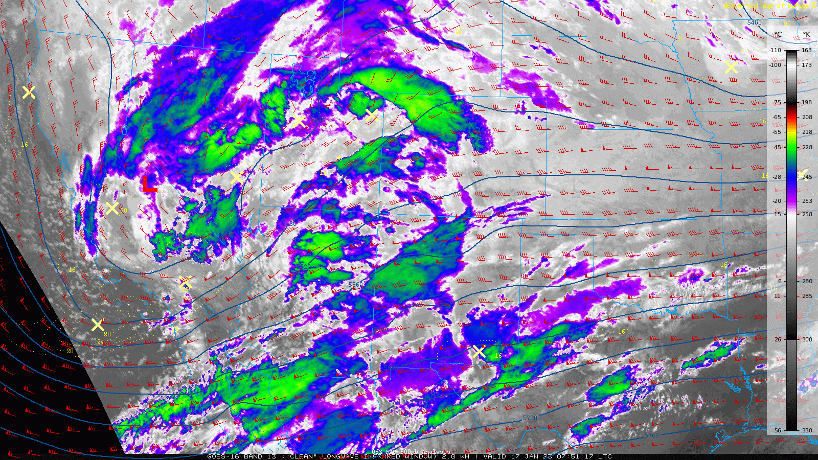
Since our forecast update Monday morning, the storm has survived all subsequent model runs fully intact. With this, we are very confident that widespread heavy snow will slam the Front Range Tuesday evening into Wednesday! As of early Tuesday morning, the strong Pacific storm system is slowly tracking towards Colorado. Currently the open-wave trough is stationed just north of Las Vegas. It will move eastward across the Four Corners and develop into a cut-off low across eastern Colorado by midnight Tuesday night.
Despite the excellent consistency in predicting this storm, we have seen a few model trends transpire that are working together to boost snowfall totals by a couple inches region-wide, especially for the western suburbs. First and foremost, the storm has slowed down slightly and the track has wobbled back southward a tad setting the stage for a longer period of deep and favorable upslope into the Front Range with this system. Upslope will get going by late afternoon on Tuesday and continue into Wednesday mid-morning — a total of approximately 18 hours. This is about six hours longer than our prior expectations — a significant change when 1 to 2″ per hour snowfall rates are thrown into the mix.
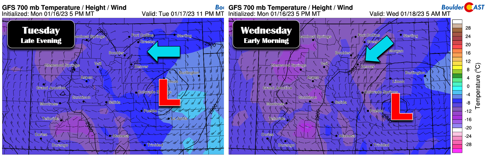
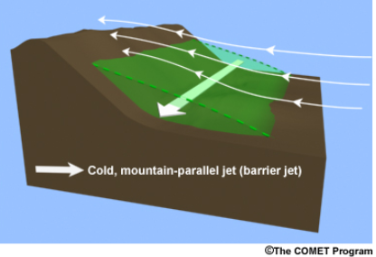
Additionally, the broad and persistent easterly flow across all of northeast Colorado, which as mentioned now appears to last several hours longer, opens the door for a weak barrier jet to setup over the Denver Metro area during the early morning hours on Wednesday. Barrier jets form when deep easterly flow is obstructed by the terrain for a prolonged period, causing low-level winds to turn towards the south near ground level. This mechanism forms a cold dense tube of air near the base of the terrain which further enhances regional upslope motion. We haven’t really seen a true barrier jet form over our area since the monster March 2021 snowstorm that dumped more than 20″ of snow on Boulder and Denver alike. Tonight’s setup is borderline for a barrier jet to form — you really need the strong, efficient upslope to last for quite a long time to turn and accelerate the winds — but nonetheless we are seeing hints for it in the models.
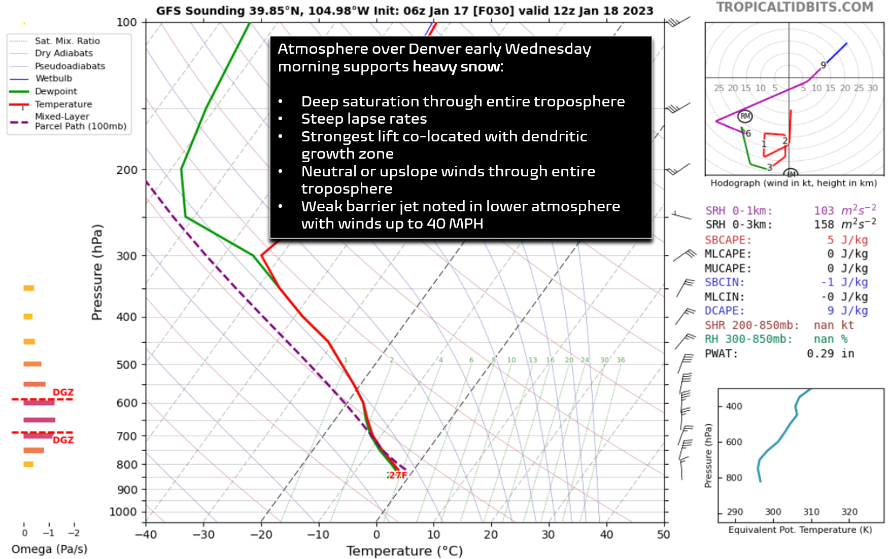
The atmospheric profile over the Denver Metro area early Wednesday morning screams heavy snow, with deep saturation and upslope through the entire troposphere (to help squeeze out all the moisture), the best lift co-located with the dendritic growth zone (to produce fluffy, rapidly accumulating snowflakes), steep lapse rates (to add instability to enhance snowfall rates), and even a weak barrier jet (to further enhance snowfall and upslope across the entire area). With such a dynamic set of ingredients coming together, we are expecting numerous hours of heavy snow from late Tuesday evening into Wednesday morning with snowfall rates of 1 to 2″ per hour. It wouldn’t be surprising at all to see some thundersnow during this event as well!
Expected Snowfall Amounts
Not surprisingly, models have been consistently nudging up snowfall amounts over the last 24 hours in response to the slower storm and longer duration of upslope. Global models do tend to still favor areas east of Interstate 25 with the heaviest snowfall. The GFS model has been the most bullish on amounts all along, and to this moment still remains on the higher end with 8 to 14″ of snow for the entire area!

The NAM model is lower overall but displays the same eastward bias with the heaviest snowfall rates, producing 6 to 11″ of snow for the Denver Metro.
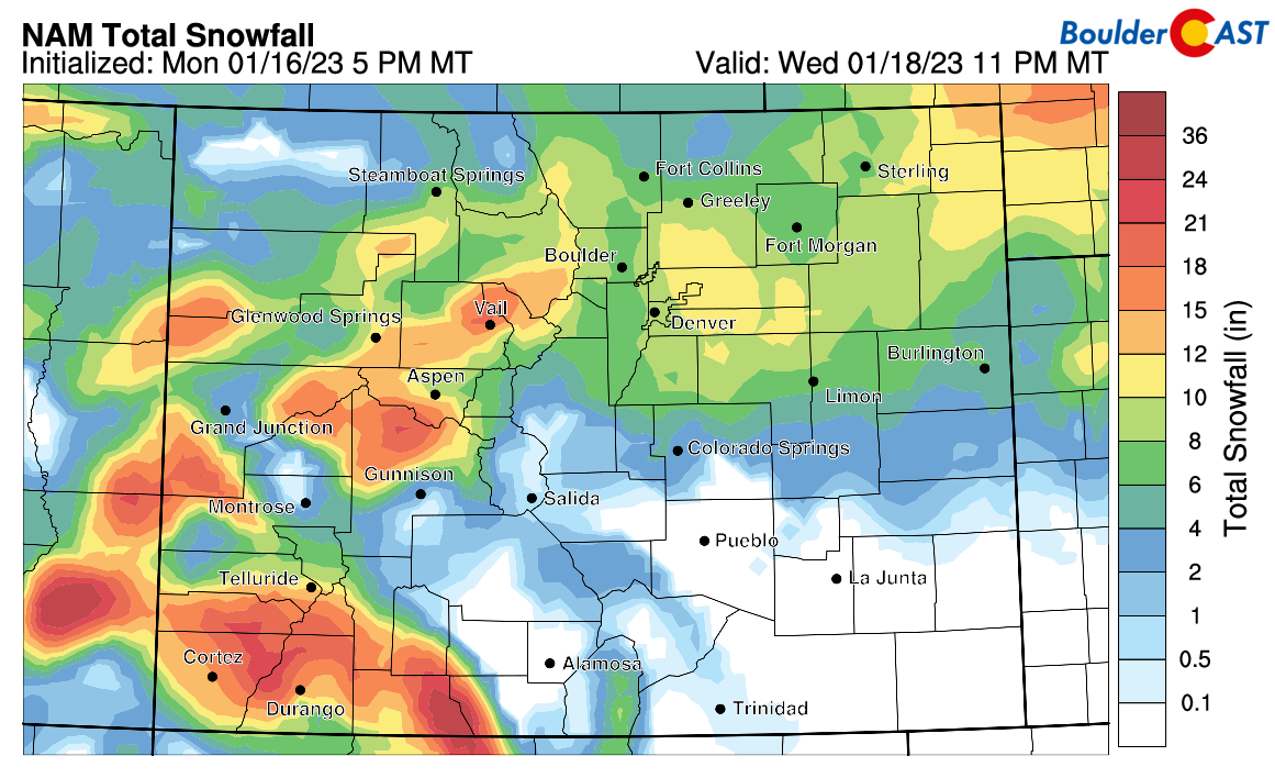
The HRRR is the only model that at least partially abandons the eastward bias, producing totals in excess of a foot east of Denver, but also in portions of the Foothills.

Overall, our blended forecast now calls for generally 6-12″ for the entire area, but we do expect there to be some locally higher totals east of Denver. Our updated snowfall forecast map is shown below covering all snowfall through Wednesday evening. Again, the highest totals should be east and southeast of Denver, with the lowest totals up towards Estes Park and west of the Continental Divide.
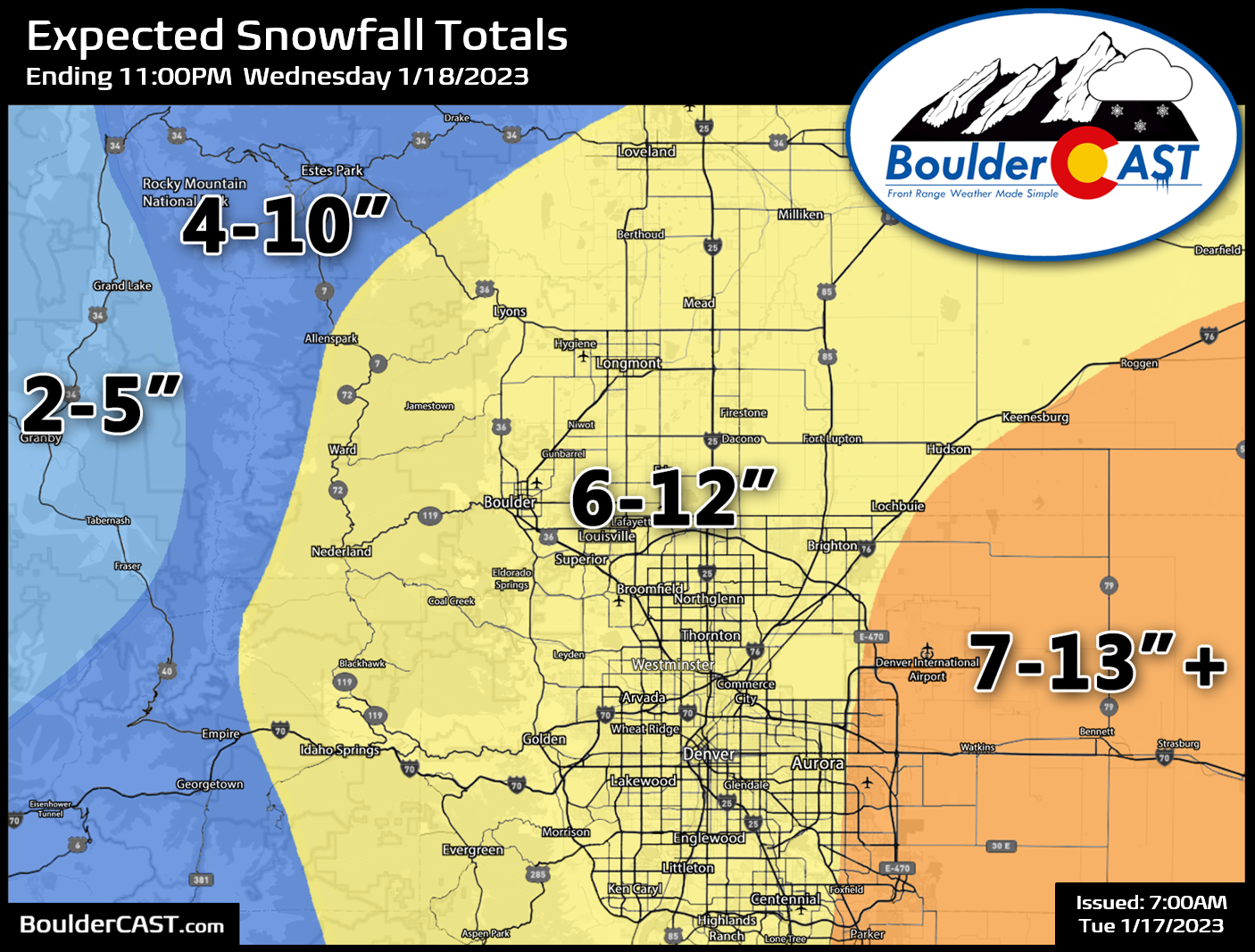
Our latest Snowfall Probabilities help to give you a good idea of the potential spread of this storm in your location. They nicely convey the fact that Boulder and the Foothills are favored to see LOWER totals from this one compared to areas to the east. In unusual fashion, DIA has the best chance to see a foot of snow!

Finally, our Twitter community usually has a sixth sense on predicting Boulder’s snowfall amount. Here’s the ongoing poll — feel free to cast your vote before the snow begins!
❄️SNOW POLL TIME! ☃️ As is tradition, how much snow do you think will Boulder receive from this winter storm? #COwx #Boulder #Colorado #COwx #COsnow #Denver
— BoulderCAST Weather (@BoulderCAST) January 17, 2023
Winter Storm Timeline
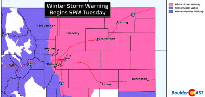
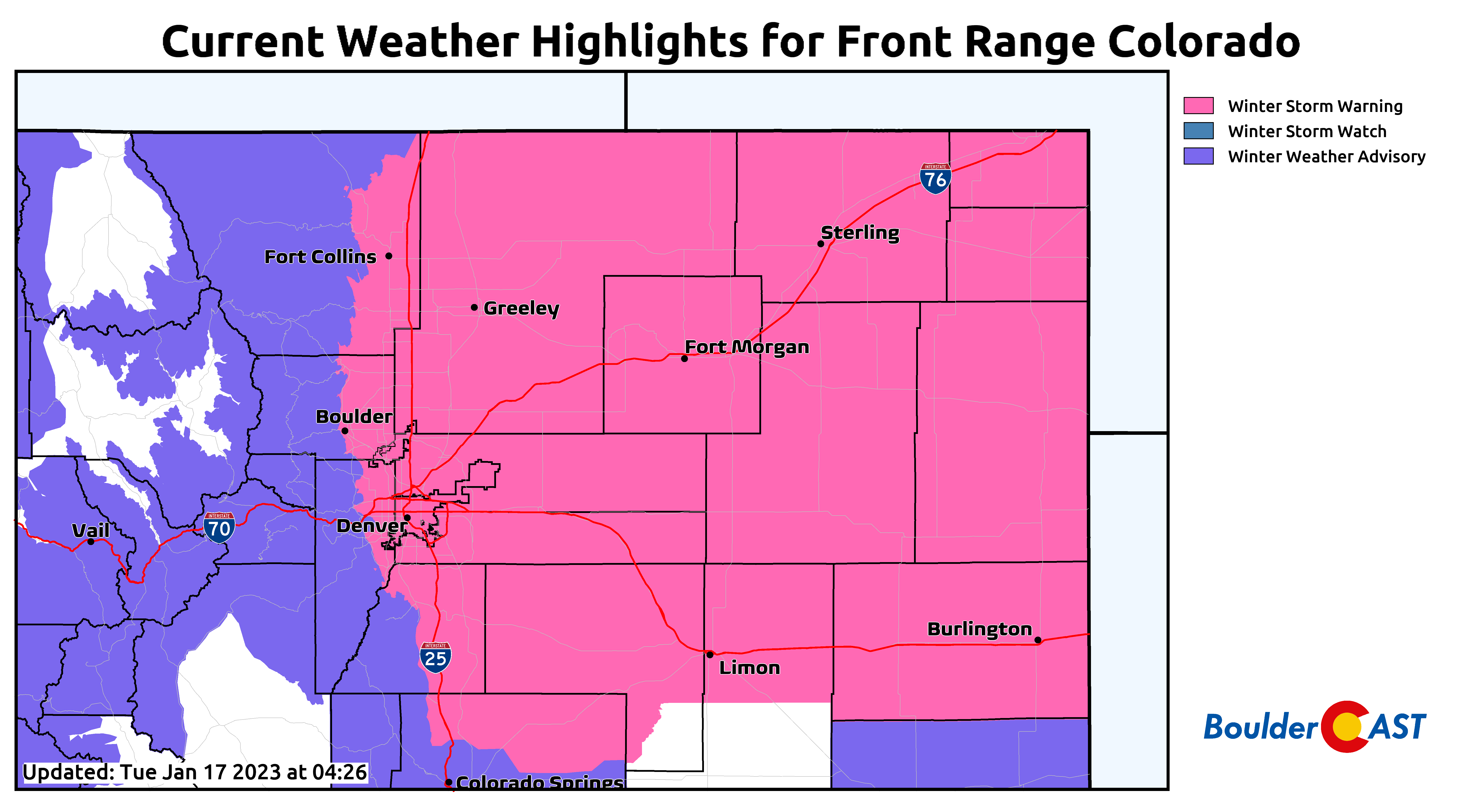
A Winter Storm Warning is posted for everywhere below 6000 feet elevation and goes into effect at 5PM Tuesday evening , with Winter Weather Advisories blanketing the higher terrain.
However, the first flakes could start flying a little sooner than 5PM, as shown in the HRRR model-simulated radar forecast:

Definitely if you can leave work a tad early on Tuesday, it would be a good idea. Snow will increase in coverage and intensity through the evening and continue well into Wednesday morning. It will be heavy at times during the overnight period with beefy snowfall rates of 2″ or even 3″ per hour in the heaviest bands not out of the question (along with possible thundersnow). The Wednesday morning commute will be completely snow-packed across the region and downright treacherous. Travel early Wednesday is not advised — please avoid the roads if you can! Considering the heavy snow and gusty winds of 25+ MPH expected out near Denver International Airport, major interruptions to flight operations are a given Tuesday evening into Wednesday afternoon. Good luck if you have to come or go through DIA in the next 36 hours!

One final comment here on the historical context of this event. Our area is no stranger to snowfall in the colder months of course, but a storm of this magnitude in January is far from commonplace — January is our driest month of the year after all (and one of the less snowy winter months).
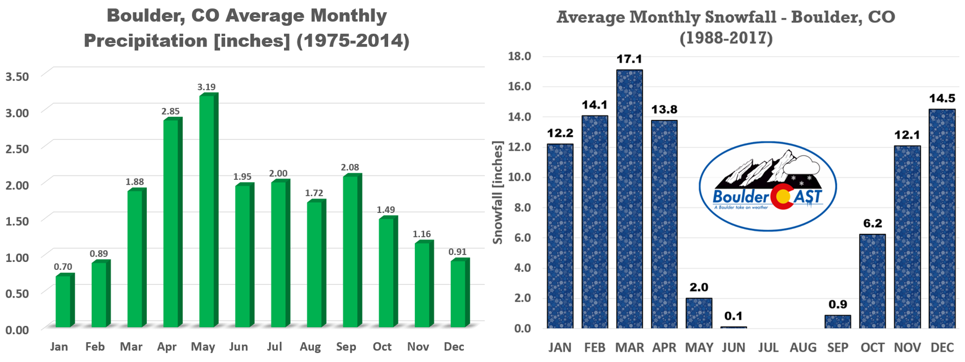
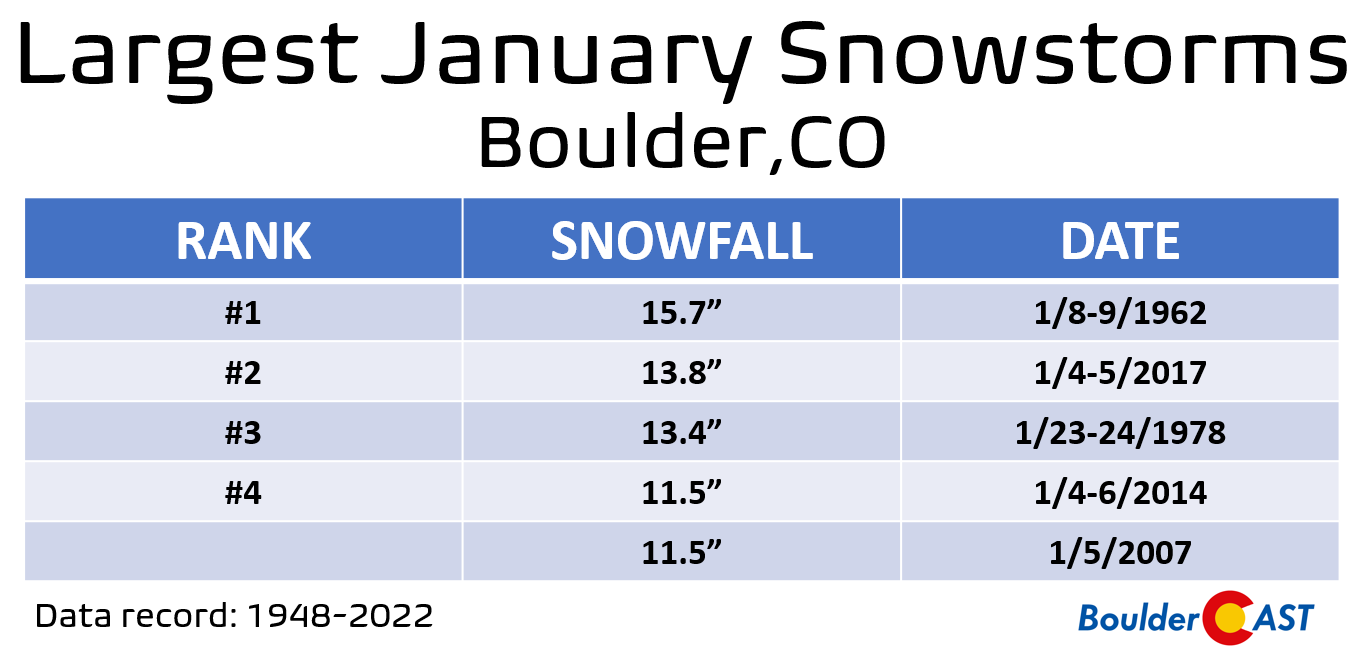
You may be surprised to learn that January snows of a foot or more are a rarity for us — mainly due to the lack of moisture in the atmosphere. Mid-winter has only a fraction of the available moisture that our big spring snowstorms can pack. If this storm ends up dumping snowfall towards the high-end of its potential, both Boulder and Denver will be flirting with all-time records for their largest January snowstorms. One of the biggest in Boulder history occurred just six years ago in 2017 — and yes we mostly nailed that forecast!
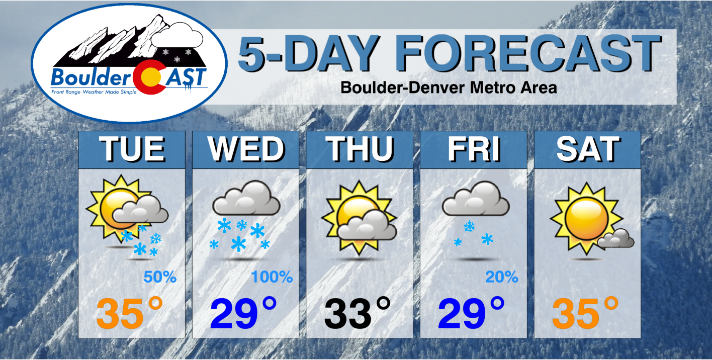
While we always appreciate the moisture here in arid eastern Colorado, not everyone is ready for another round of deep snow that will stick around for the days and probably weeks to come as temperatures are forecast to remain below normal for at least the next ten days!
Mixed in with the colder temperatures, there are also more chances for snow already in the pipeline….
We’ll have one final forecast discussion posted later today for our Premium subscribers. Otherwise, that’s all of our thoughts for now. Let it snow!
P.S. Is it spring yet?!
Get BoulderCAST updates delivered to your inbox:
Enjoy our content? Give it a share!


You must be logged in to post a comment.