A bitter cold Arctic front blasted into the Front Range over the weekend bringing a quick change in our weather including record cold sub-zero temperatures and persistent light snow. The Arctic airmass remains entrenched for our Monday with more snow in the forecast, but things turn quiet and sunny rather quickly in the days to follow. Temperatures will slowly moderate the rest of the week so keep those shorts and t-shirts handy — we should get back near 50 degrees by the end of the week!
This week’s highlights include:
- Bitter cold temperatures and light snow continue on Monday with the area firmly entrenched in the Arctic airmass
- Temperatures moderate through the rest of the week, but still several days of below normal temperatures lie ahead
- Lots of sunshine Tuesday through Thursday will help things feel warmer
- Getting close to 50 degrees by Friday
- The next chance of snow east of the Mountains does not come until early next week most likely
DISCLAIMER: This weekly outlook forecast is created Monday morning and covers the entire upcoming week. Accuracy will decrease as the week progresses as this post is NOT updated. To receive daily updated forecasts from our team, among many other perks, subscribe to BoulderCAST Premium.

A bitter cold Monday stuck in the Arctic airmass
Most of the week ahead in the Front Range will be spent trying to escape from the Arctic airmass which moved in Saturday evening. In the wake of the strong front, Sunday’s daytime high was only 3°F in Boulder with light snow and low clouds persisting all day long. It wasn’t much warmer in Denver either.
Today is for sure to see an (early period) midnight high of 9°F. We've been locked at 3° for the last five hours with no hopes of warming up much further today as low clouds and very light snow both stick around #COwx #Boulderwx pic.twitter.com/462927ycEZ
— BoulderCAST Weather (@BoulderCAST) January 29, 2023
As of Monday morning, temperatures across a large portion of the central and western United States are below zero — with wind chills even colder in the -30s in spots!
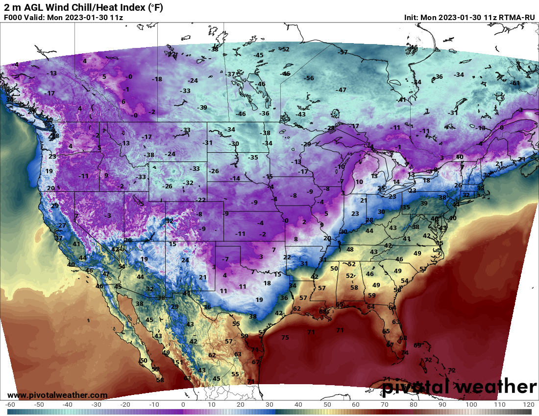
Monday morning wind chill readings across the nation
The same bitter cold air is entrenched across the Denver Metro area, too. Thankfully winds are almost non-existent out there Monday morning and thus wind chills are not too bad over most of the area — basically just sitting square at the ambient temperatures for most of us — which nonetheless are still very cold in the negative single digits!
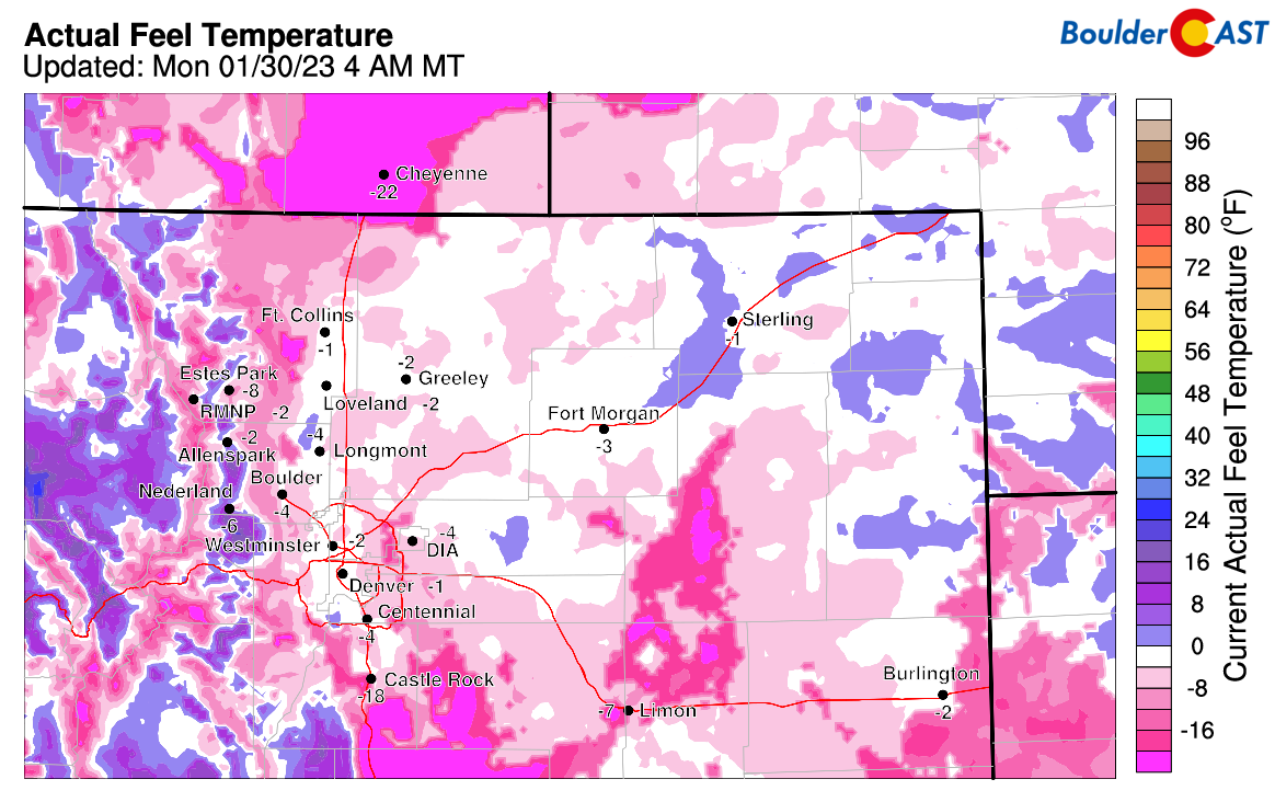
Wind chills in the Front Range early Monday morning
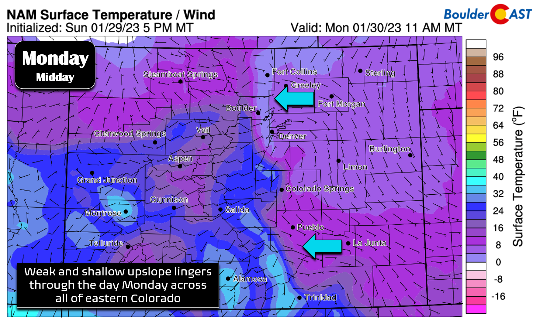
In addition to the frigid air, low-level upslope has been ongoing for the last 36+ hours and that won’t be changing on Monday. All of eastern Colorado will remain under the influence of weak and shallow upslope through the day. This setup has been producing steady but very light and dry snowfall for the area and this will continue for a little while longer (though there will be some sun around early Monday morning)…
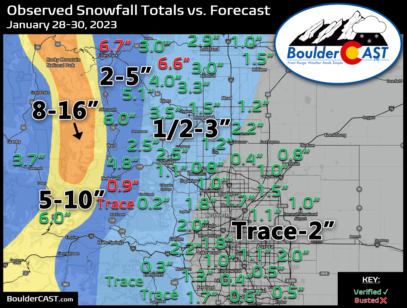
However, outside of the Foothills, the snow hasn’t really amounted to much and that will be the case again on Monday. Here’s a look at the regional snowfall totals (through Monday morning) compared to our forecast issued back on Saturday. Green values indicate that our forecast verified to within one inch of the observed snowfall total. Red numbers did not. Generally a dusting to 3″ fell across the area with good verification, though some higher totals were observed in the Foothills — up to 6″ near Estes Park.
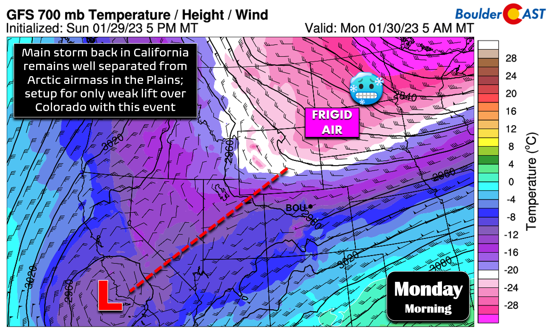
Part of the problem with getting the snowfall going is just how far away the parent storm is located — it’s way back off the coast of southern California as of Monday morning. Very little lift and energy has made it into our area with this event (with the exception of good orographics in the northern Mountains). Almost all of the snow in the Metro area has been fueled by the Arctic air slowly banking up against the terrain.
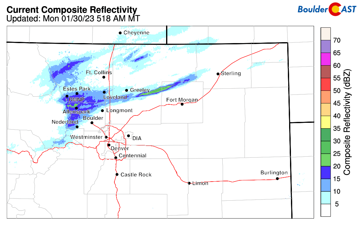
There is a weak jet streak overhead which has been enhancing snowfall in the northern Front Range Sunday into Monday morning. This has definitely been the case in the higher Foothills of Boulder and Larimer Counties — we are expecting to see some booming snow totals there! Current radar as of 6:00AM Monday has most of the accumulating snowfall north of Boulder and Longmont with a few more moderate pockets of snow mixed in.
Radar animation in the Front Range early Monday morning
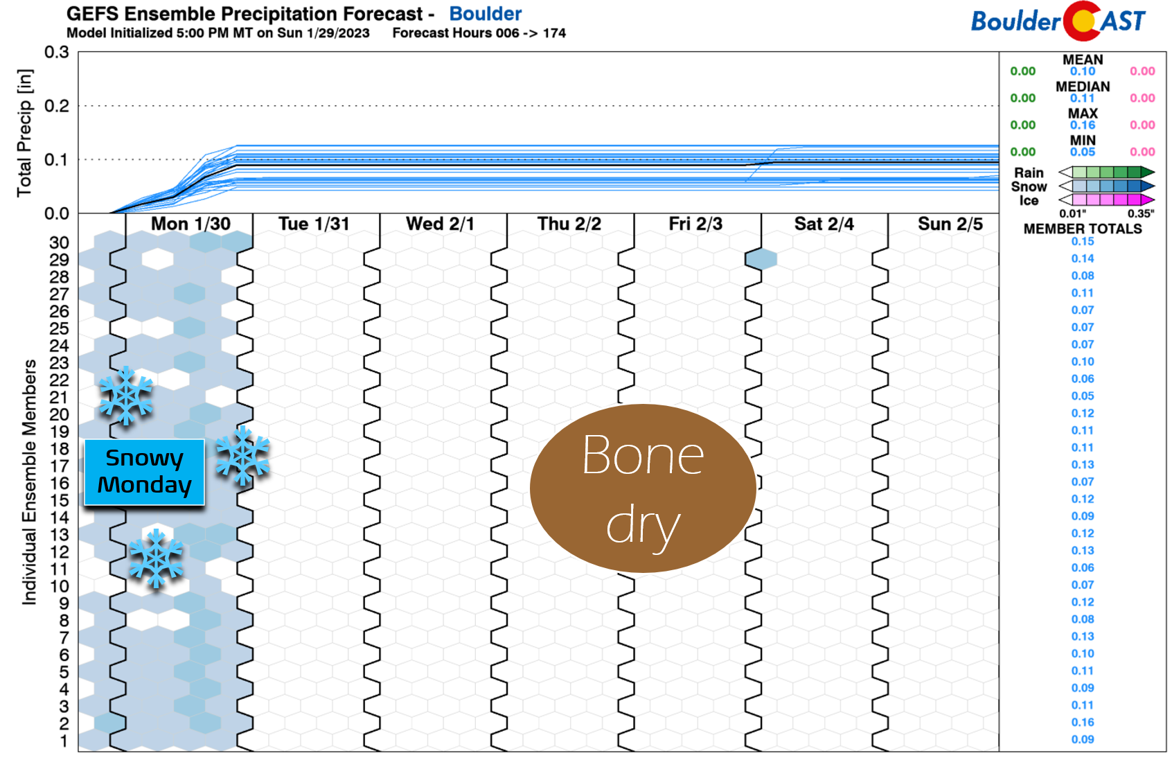
The jet energy will sag southward and weaken through the day Monday into Monday night but may help to enhance snowfall briefly around Boulder and Denver as it passes through. As mentioned, most of us are looking at just another 1″ of snow or less by the time things wrap up fully Monday night.
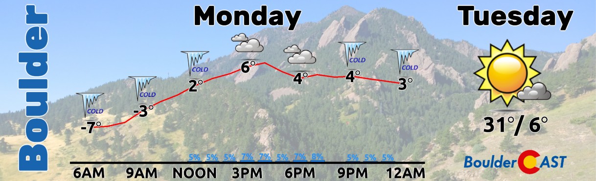
High temperatures on Monday will top out in the single digits again by mid-afternoon, just like Sunday. However, for what it’s worth, we should get a few degrees warmer — perhaps into the mid to upper single digits! Bundle up with a few extra layers if you’re heading outside on Monday — especially in the morning hours when wind chills are well below zero.
Quiet the rest of the week with a welcomed warming trend
Once we get through Monday, the absolute coldest readings will already be behind us with rising temperatures expected beginning late Monday night as the Arctic airmass loosens its grasp on eastern Colorado. The lack of much snowfall from this event will work in our favor — allowing for a quicker rebound in temperatures than otherwise would have been the case had heaps of snow dumped here. Don’t get the wrong impression through — we’re still looking at a few subsequent days of below normal temperatures, but nothing too terrible in the grand scheme of things. Tuesday should get us back into the 30s, with 40s to follow during the midweek period, and then close to 50 degrees by Friday. Any recent snow should melt away rather quickly with plentiful sunshine expected.
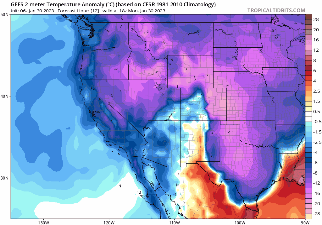
GFS ensemble mean surface temperature anomaly forecast animation Monday through Friday night. Bitter cold moderates quickly towards above normal temperatures in Colorado by Friday.
Model ensembles keep the Boulder-Denver Metro area entirely dry through the rest of the week and upcoming weekend. It’s not until early next week that we start to see a more active pattern return to the central Rockies, at least one that would be capable of producing snowflakes for us once again…
Stay safe, stay warm and enjoy the rebounding temperatures in the coming days!
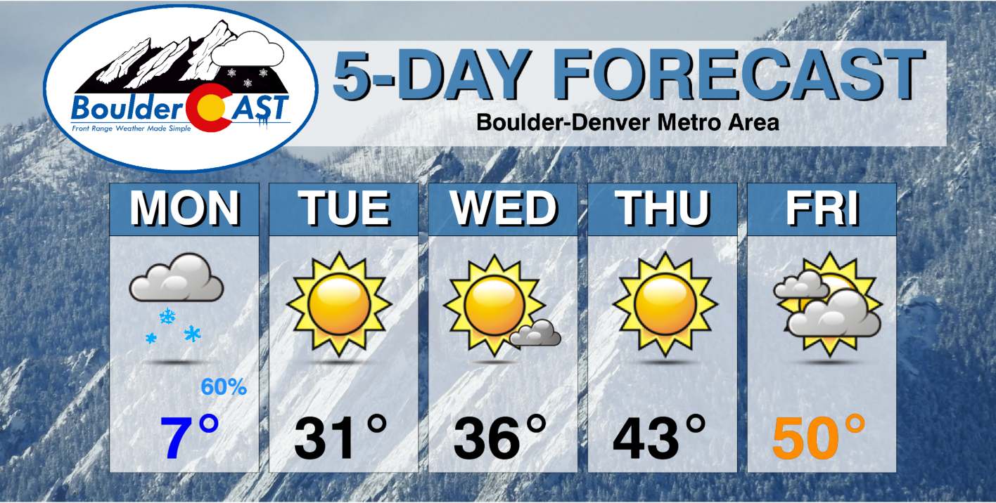
Forecast Specifics:
Monday: Mostly cloudy with flurries and light snow possible through the day. Some weak banded snow may briefly enhance snowfall rates at times but these should be few and far between. A trace to 1″ of additional snowfall expected, with a couple inches in the higher Foothills of Larimer and Boulder Counties. Highs in the positive single digits on the Plains and negative single digits in the Foothills.
Tuesday: Sunny but still cold with highs in the lower 30s on the Plains and in the middle 20s on the Foothills.
Wednesday: Mostly sunny and chilly with temperatures reaching the upper 30s on the Plains with upper 20s in the Foothills.
Thursday: Sunny and slightly warmer with temperatures in the lower to middle 40s on the Plains with lower 30s in the Foothills.
Friday: Partly to mostly cloudy and mild with highs near 50 degrees on the Plains and in the upper 30s in the Foothills.
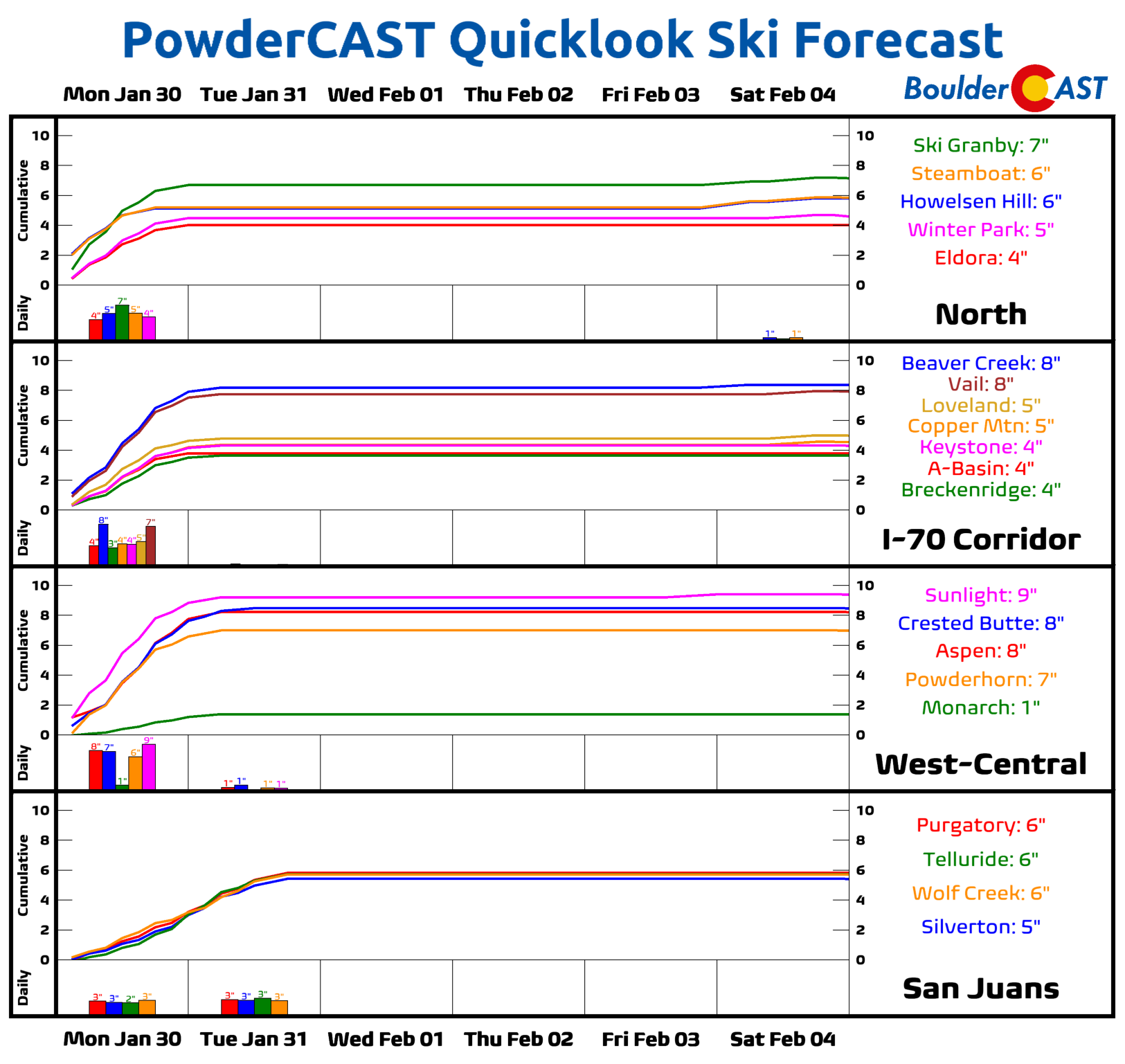
PowderCAST: Almost all of the snow this week in the Mountains will occur on Monday with another 4 to 8″ of snow expected at most resorts. The rest of the week will be mostly quiet and dry with little to no chance of any additional powder. A weak system may clip the area late Friday into Saturday bringing light snow to the Mountains again, but only a couple inches or less are expected for now with that event. Bundle up as conditions are brutally cold in the High Country as well during the early week!
Help support our team of Front Range weather forecasters by joining BoulderCAST Premium. We talk Boulder and Denver weather every single day. Sign up now to get access to our daily forecast discussion email each morning, complete six-day skiing and hiking forecasts powered by machine learning, first-class access to all our Colorado-centric high-resolution weather graphics, bonus storm updates and much more! Or not, we just appreciate your readership!
Spread the word, share the BoulderCAST forecast!


You must be logged in to post a comment.