The week starts off mild and relatively quiet in the Front Range, but trends chilly and unsettled yet again by mid to late week. Mother Nature wants to keep a rather active pattern around for us to begin the month of May. There is also a possibility of some snow mixing in for the latter part of the week, but chances for this drop dramatically from a climatology perspective once May rolls around. Read on as we break down our weather for the week ahead.
Category: Winter Weather (Page 22 of 134)
These posts contain some discussion of the white stuff, whether it be mountain snow pack or a Front Range snowstorm.
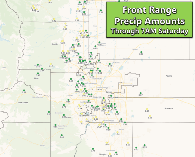
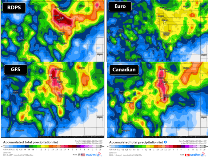
A developing Four Corners low pressure system will move across southern Colorado this weekend producing a prolonged period of moist upslope flow into the Front Range. While temperatures will (fortunately) be too warm for snowfall across the lower elevations, anywhere from 1 to 4″ of rainfall is expected to dump on our area. Where temperatures are colder, the higher Foothills and Mountains could see over 2 feet of snow from this system as well. Here’s our latest thoughts on the incoming soggy rain (snow) storm!
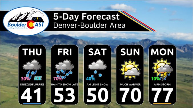
After another round of spring snow over the weekend, the pattern will stay somewhat active across the Front Range this week, but with the warmer late April temperatures translating to only rain chances for the lower elevations. Unfortunately it looks like the gloom will stick around into the upcoming weekend as well. Let’s take a look.

After a month long hiatus, widespread accumulating snowfall will return to the Front Range late Friday as a classic jet-forced banded snowfall event unfolds across the area. While final snowfall totals will undoubtedly vary from location to location, we discuss the latest details of the springtime snowflakes knocking on our door, including when things will commence and expected travel impacts.
Warm temperatures, low humidity, and strong gusty winds will start our week with continued fire danger across the Plains. A strong area of low pressure will also bring the threat of rain showers late Monday into Tuesday to the Denver Metro area, with heavy snow piling up in the Mountains. Later in the week, a cold front will slide down ushering in below normal temperatures and upslope flow. A prolonged period of unsettled weather will follow this front, with even some late-season snow possible in the Metro area and heavy snow looking likely in the Foothills. Read on to find out more.

Live View of Boulder

Current Conditions

Live Radar

Recent Premium Posts

BoulderCAST Daily – Thu 01/15/26 | Fire Danger Today Before a Cold Front Tonight
🔥 Fire danger rising — Warm and windy today ahead of a strong …
BoulderCAST Daily – Wed 01/14/26 | A gorgeous Wednesday ahead of increasing fire danger & a stronger cold front tomorrow
🌬️ Weak front overnight — A weak cold front slipped through around 9:30 …
BoulderCAST Daily – Tue 01/13/26 | A thick blanket of high clouds won’t stop us from reaching the 60s again
☁️ Thick cloud deck overhead — Moisture streaming in aloft brings widespread mid‑ …
3-Day Forecast

Trending Content

© 2026 Front Range Weather, LLC