Warm temperatures, low humidity, and strong gusty winds will start our week with continued fire danger across the Plains. A strong area of low pressure will also bring the threat of rain showers late Monday into Tuesday to the Denver Metro area, with heavy snow piling up in the Mountains. Later in the week, a cold front will slide down ushering in below normal temperatures and upslope flow. A prolonged period of unsettled weather will follow this front, with even some late-season snow possible in the Metro area and heavy snow looking likely in the Foothills. Read on to find out more.
This week’s highlights include:
- Fire concerns continue: For Monday into Tuesday, a strong storm system will bring warm temperatures, low humidity, and strong gusty winds between 30 and 50 MPH. This will continue fire concerns for area east and south of Denver.
- Mild temperatures trend below normal: Temperatures in the 60s and 70s to start the work week will trend below normal towards the 40s and 50s by week’s end
- Rain chances early in the week, with snow chances for the latter: A tenth to one quarter of an inch of rain is possible late Monday into Tuesday with a strong area of low pressure moving through. A late-week cold front and jet streak will bring a chance of rain and snow for the Plains. Snow amounts vary widely but could accumulate a few slushy inches, with much higher snow potential expected in the Foothills.
DISCLAIMER: This weekly outlook forecast is created Monday morning and covers the entire upcoming week. Accuracy will decrease as the week progresses as this post is NOT updated. To receive daily updated forecasts from our team, among many other perks, subscribe to BoulderCAST Premium.

Go Premium, get all the perks.
Daily Forecast Updates
Get our daily forecast discussion every morning delivered to your inbox.
All Our Model Data
Access to all our Colorado-centric high-resolution weather model graphics. Seriously — every one!
Ski & Hiking Forecasts
6-day forecasts for all the Colorado ski resorts, plus more than 120 hiking trails, including every 14er.
Smoke Forecasts
Wildfire smoke concentration predictions up to 72 hours into the future.
Exclusive Content
Weekend outlooks every Thursday, bonus storm updates, historical data and much more!
No Advertisements
Enjoy ad-free viewing on the entire site.
Fire concerns, gusty winds, & rain chances to start
After tying a record high temperature on Sunday, a busy weather week is in store with gusty winds, low humidity and mild temperatures to begin. However, colder weather and eventually snow may develop late in the week. We’ll discuss all of that in this post, but for now let’s focus on Monday.
🌡️🏆 Boulder tied a daily record high temperature on Sunday reaching 80°F, the first eighty-degree reading of 2024! This specific record is now shared among five different April 14ths, the most recent being 1982. #COwx #Boulderwx #Boulder #RecordHigh pic.twitter.com/HGbu1OeOEh
— BoulderCAST Weather 🏔️❄️ (@BoulderCAST) April 15, 2024
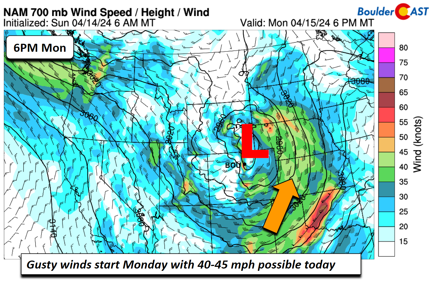
Fire concerns will be the main story for the start of the week. A very strong low pressure system will deepen as it tracks into Nebraska and Kansas later Monday night and into Tuesday. Gusty winds will commence on Monday as the low starts to strengthen. Gusts on the eastern Plains could reach speeds of 40-45 MPH out of the west and southwest. These gusty winds will combine with dry fuels and mild temperatures in the upper 70s for elevated fire danger once again.
On top of these gusty winds and fire concerns, the strong system will bring wrap-around moisture starting late tonight and continuing into midday Tuesday. The majority of this precipitation will reside in the Foothills and High Country with periods of heavy orographic snow. The Plains will be largely under a downslope northwest flow, but enough wrap-around moisture should manage to produce a few rain showers for us overnight and into Tuesday.
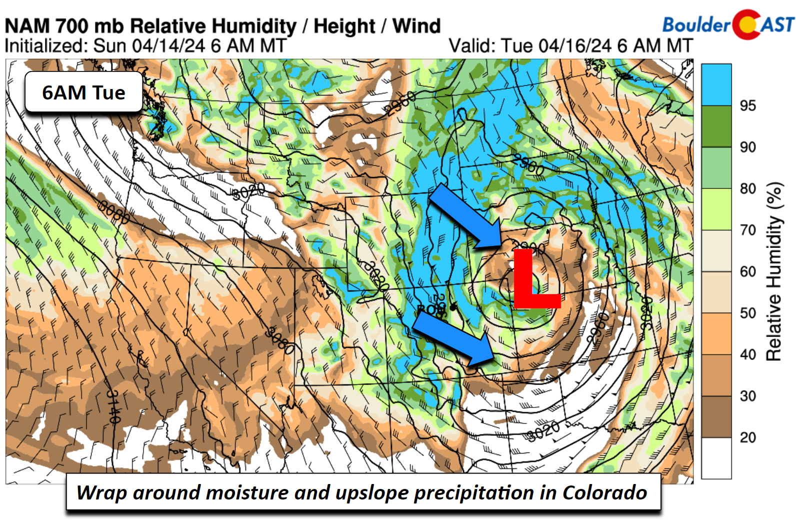
The NAM shows this depiction quite well below. Note the heavy precipitation along/west of the Divide, a function of strong upslope and from those northwest winds. On the Plains, some wrap-around precipitation is expected, but it’ll be very limited in scope.
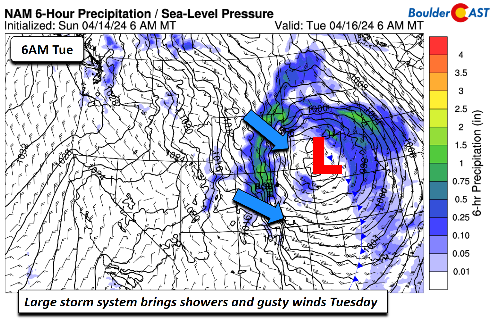
The main story will be northwest winds of 45-50 MPH east of Denver, highest during the day Monday into Tuesday. This will bring another round of fire concerns Monday, but temperatures will be a few degrees cooler in the Metro area only reaching the lower 70s under slight cold advection.
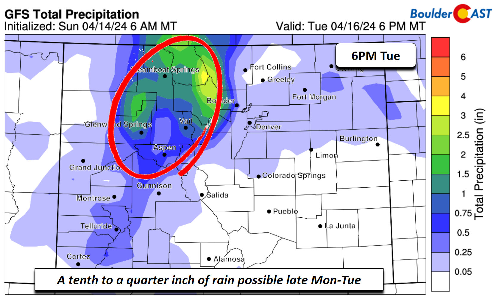
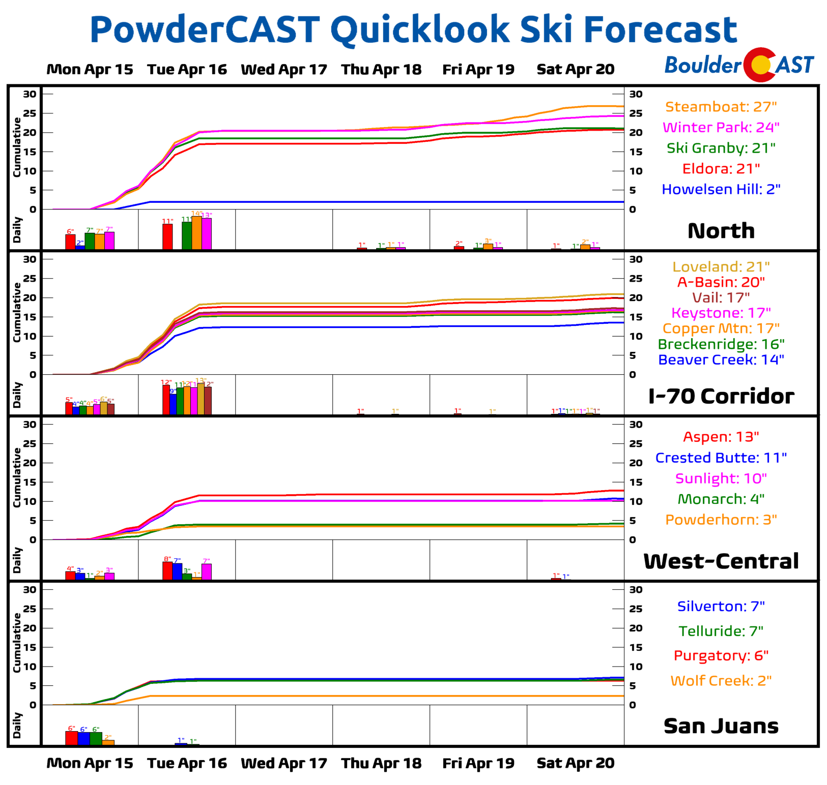
Rainfall amounts on the Plains by late Tuesday are not expected to be more than a quarter inch. In fact, a tenth of of an inch or less is forecast from most model guidance. The bullseye in precipitation, in the form of snow, is expected over the northwest Mountains and into Steamboat, where 1-2 inches of liquid are possible!
Most high-res guidance shows that a few feet of snow is likely over the higher terrain slopes in this region.
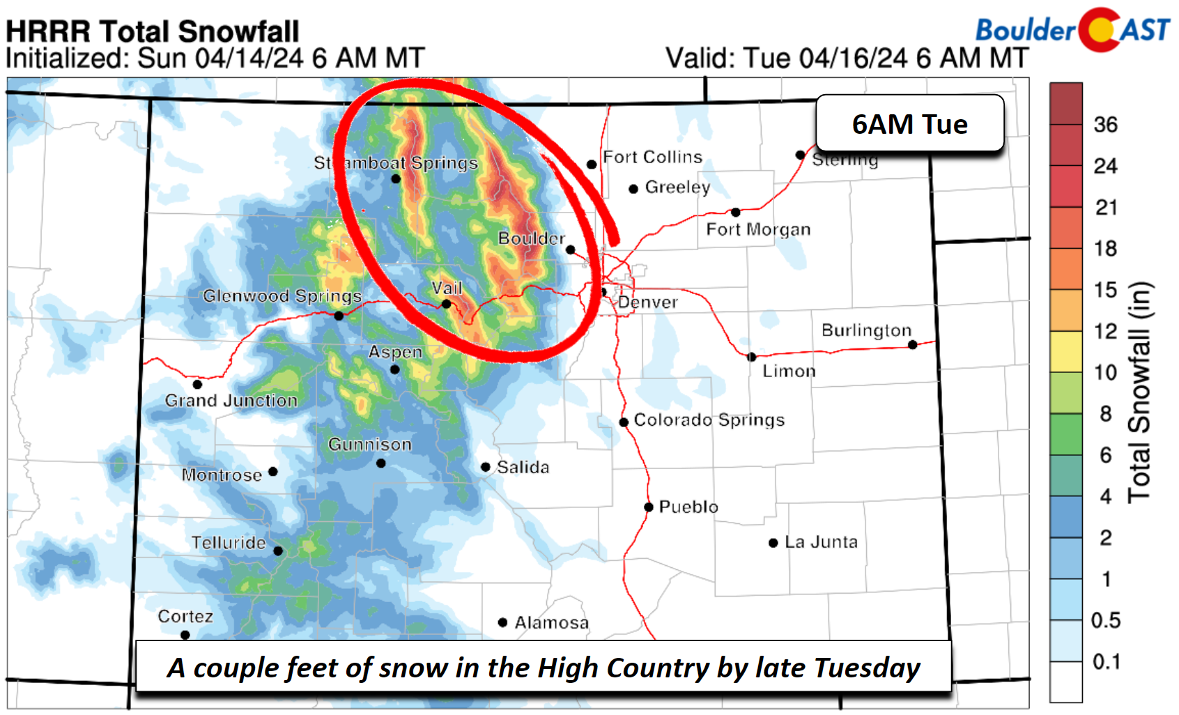
Skiers certainly will be celebrating the late-season powder!
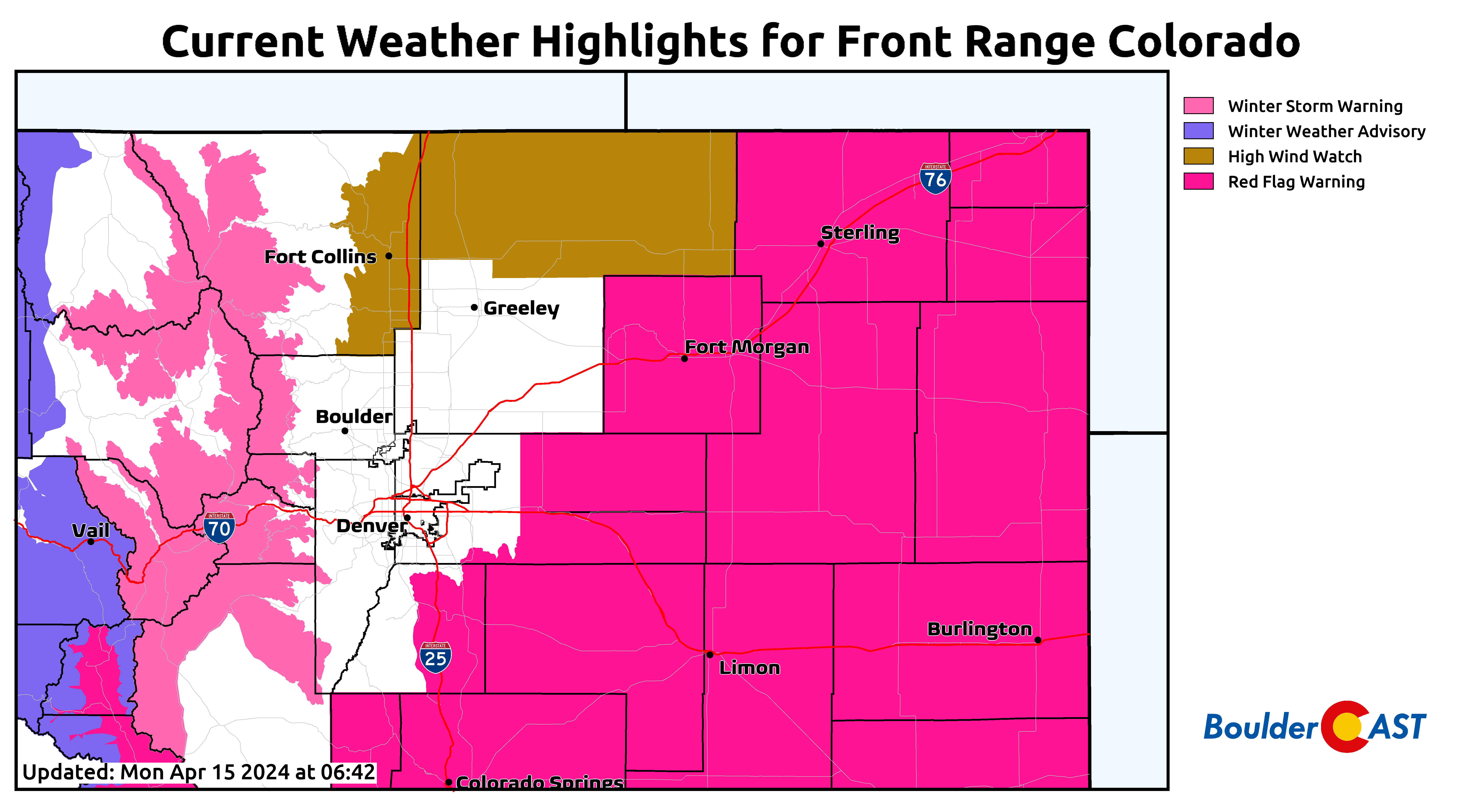
Current highlights across Colorado show another classic “Fire & Ice” situation on Monday with Winter Storm Warnings in the High Country, nothing in the Metro area, and Red Flag Warnings to the east.
Winter isn’t over yet with snow possible late this week!
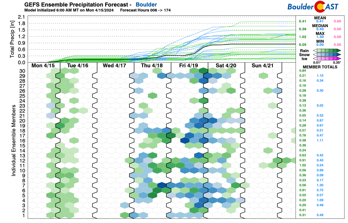
While the white stuff won’t reach into the Metro area early in the week, there are some hints that flakes could fall later Thursday and Friday and into the first part of the weekend. A fair bit of model spread exists, but guidance is showing a favorable pattern of colder weather and a jet streak that could bring snow to the Plains, as suggested by the GEFS. Let’s take a closer look!
While Wednesday will be a quiet and mild day with highs in the 70s, a cold front is slated to move through late Wednesday night or early Thursday morning. This frontal passage will set up a prolonged period of upslope chilly air into the first part of the weekend with highs likely ranging from the upper 40s to lower 50s, although it could be lower if the trend is colder.
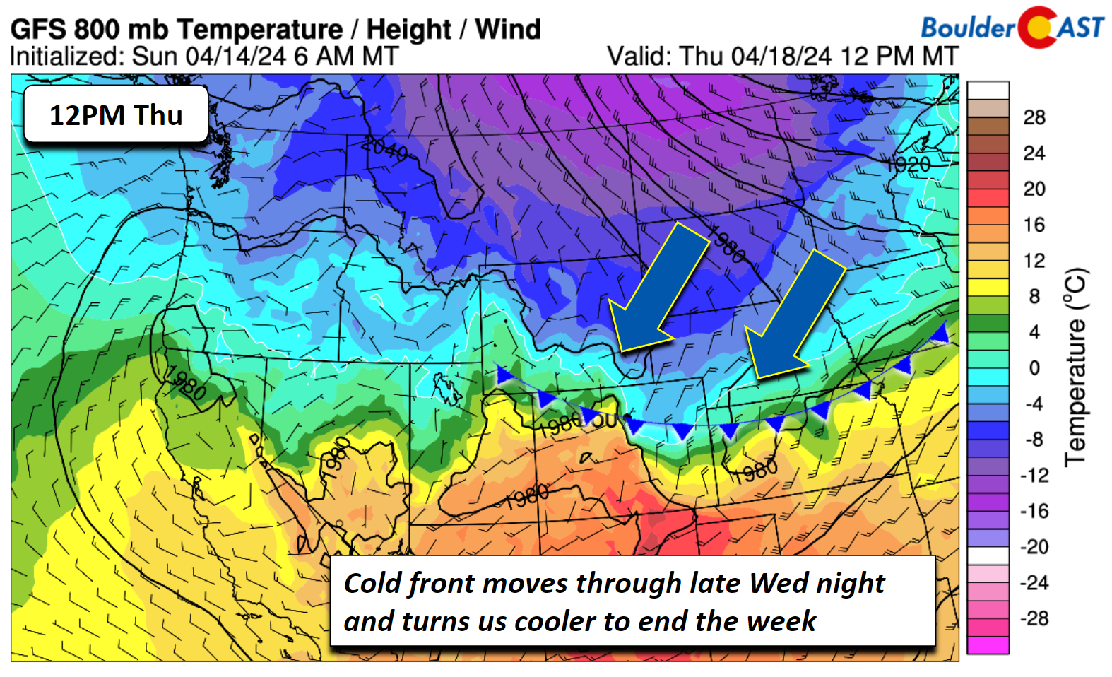
Coupled to the frontal passage later this week is a trough over the north and energy from the southeastern Pacific. This energy is forecast to intercept the region Thursday in to Saturday for precipitation chances.
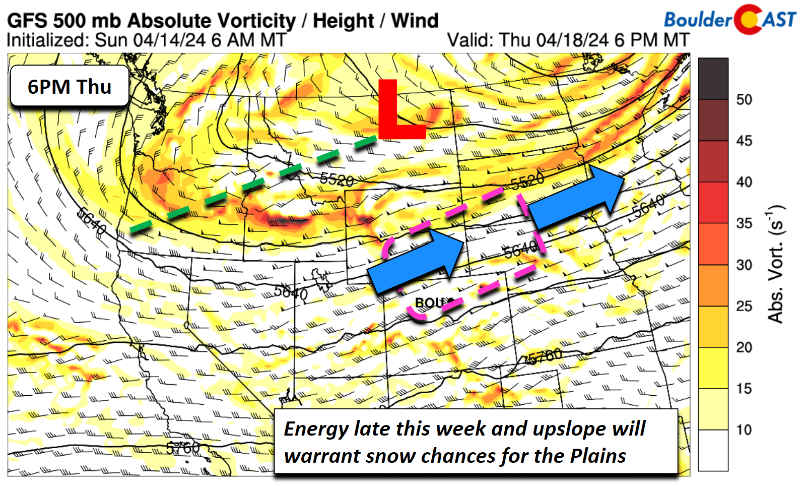
Lastly, an upper-level jet streak is indicated to be just north of the area, from Wyoming into the upper Midwest. The placement of this could favor banded precipitation, perhaps in the form of snow as well given borderline temperatures.
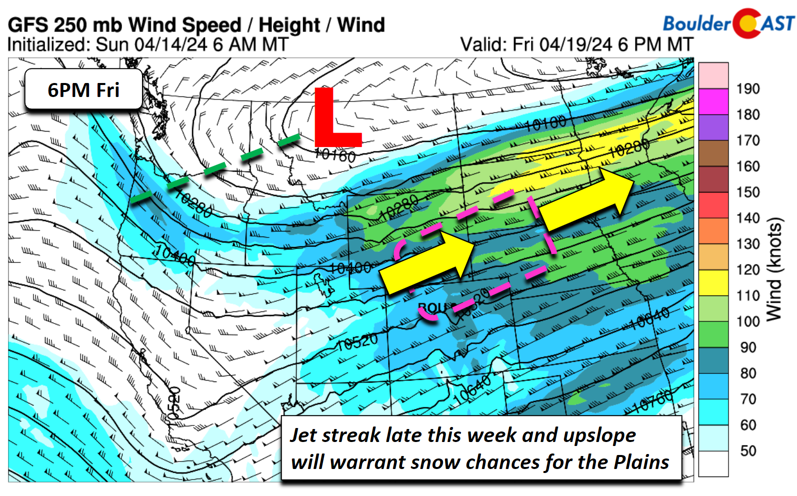
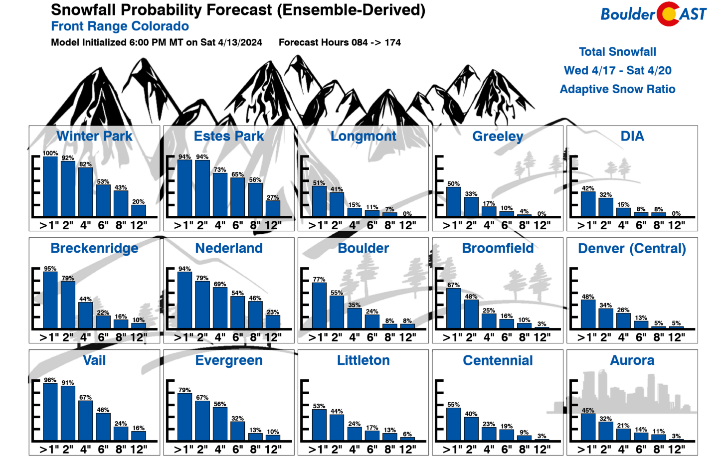
There are a lot of questions to consider for this late-week system and too much model spread to share much certainty at this stage. Late-season snow is always difficult to predict with more daylight hours and warmer ground/air temperatures — not to mention the actual spread in ensemble data. However, what we have seen so far, it is hard to argue against at least putting a chance of snow in the forecast with the near-freezing low-level temperatures by late-week. Potential snow accumulations look significant in the higher Foothills (6 inches or more), especially from Boulder County northward. Snow accumulations across the lower elevations are more uncertain right now due to marginal temperatures, but generally only minor amounts look possible right now (less than 3″). For what it is worth, our snowfall probabilities indicate a ~50% chance for at least 1″ of snow in Boulder/Denver, but there is also a chance things fall as mostly rain.
We will be watching this late-week storm system closely as the week progresses, so stay tuned. This week will offer a classic spread of Colorado springtime weather. Enjoy!
Get BoulderCAST updates delivered to your inbox:
Forecast Specifics:
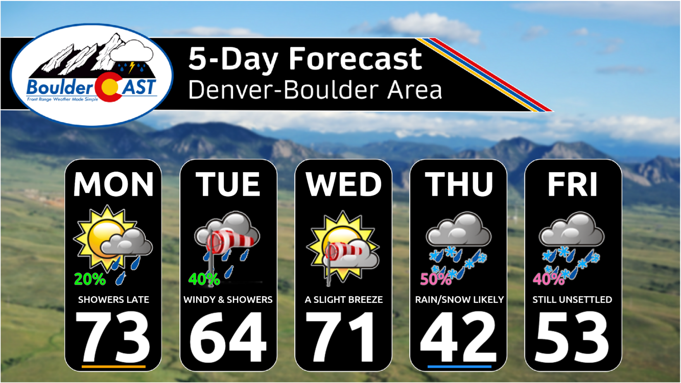
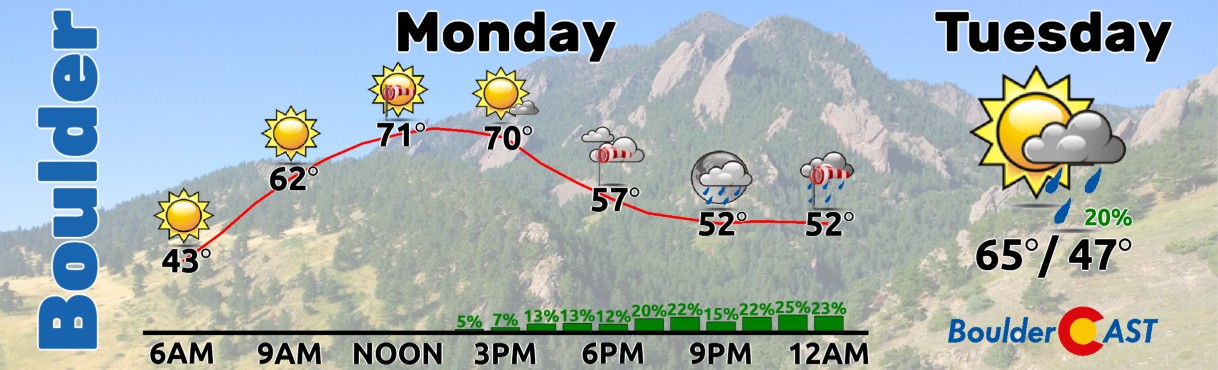
Monday: Breezy, warm, and low humidity with elevated fire concerns, mainly east of Denver. Increasing clouds with a chance of evening/overnight showers. Highs in the lower 70s for the Plains and lower 60s in the Foothills. Downslope winds will gust over 40 MPH in the evening and overnight period.
Tuesday: Partly sunny with morning light rain showers, then very windy with gusts upwards of 50 MPH. Highs in the middle 60s for the Plains and lower 50s in the Foothills.
Wednesday: Sunny, mild, and slightly breezy with highs in the lower 70s for the Plains and lower 60s in the Foothills.
Thursday and Friday: Increasing clouds and colder with a chance of rain and snow showers both days. Highs could range from the 40s to the 50s with lows in the 30s.
DISCLAIMER: This weekly outlook forecast is created Monday morning and covers the entire upcoming week. Accuracy will decrease as the week progresses as this post is NOT updated. To receive daily updated forecasts from our team, among many other perks, subscribe to BoulderCAST Premium.
Go Premium, get all the perks.
Daily Forecast Updates
Get our daily forecast discussion every morning delivered to your inbox.
All Our Model Data
Access to all our Colorado-centric high-resolution weather model graphics. Seriously — every one!
Ski & Hiking Forecasts
6-day forecasts for all the Colorado ski resorts, plus more than 120 hiking trails, including every 14er.
Smoke Forecasts
Wildfire smoke concentration predictions up to 72 hours into the future.
Exclusive Content
Weekend outlooks every Thursday, bonus storm updates, historical data and much more!
No Advertisements
Enjoy ad-free viewing on the entire site.
Enjoy our content? Give it a share!


You must be logged in to post a comment.