After a month long hiatus, widespread accumulating snowfall will return to the Front Range late Friday as a classic jet-forced banded snowfall event unfolds across the area. While final snowfall totals will undoubtedly vary from location to location, we discuss the latest details of the springtime snowflakes knocking on our door, including when things will commence and expected travel impacts.
At a Glance:
- Spring Snow Returns: A spring snowstorm is expected to hit the Front Range late Friday, April 19, 2024, after a month-long break from snow.
- The Dynamics: The snow event will be driven by surface upslope and jet stream interactions, leading to banded snowfall across the area.
- Snowfall Timing: Snow is predicted to start Friday afternoon and continue overnight into Saturday morning
- Snowfall Amounts: 1 to 5 inches expected broadly across the lower elevations, but with higher totals in persistent bands. 3 to 8 inches are expected in the Foothills.
- Back to Spring by Sunday: The weather will clear up wonderfully by Sunday with 60s and 70s returning in no time at all

Go Premium, get all the perks.
Daily Forecast Updates
Get our daily forecast discussion every morning delivered to your inbox.
All Our Model Data
Access to all our Colorado-centric high-resolution weather model graphics. Seriously — every one!
Ski & Hiking Forecasts
6-day forecasts for all the Colorado ski resorts, plus more than 120 hiking trails, including every 14er.
Smoke Forecasts
Wildfire smoke concentration predictions up to 72 hours into the future.
Exclusive Content
Weekend outlooks every Thursday, bonus storm updates, historical data and much more!
No Advertisements
Enjoy ad-free viewing on the entire site.
I
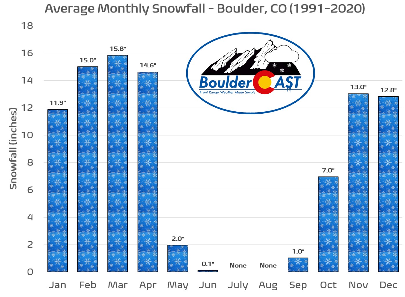
t has been a while, but we’re back with another winter weather update for you! Whoa….hold on a second — you didn’t think winter was over did you? Well of course it is, technically speaking, but we all know that winter weather extends well outside of the season’s official bounds here in the Front Range. In fact, April is Boulder’s third snowiest month of the year with nearly 15 inches falling on average:
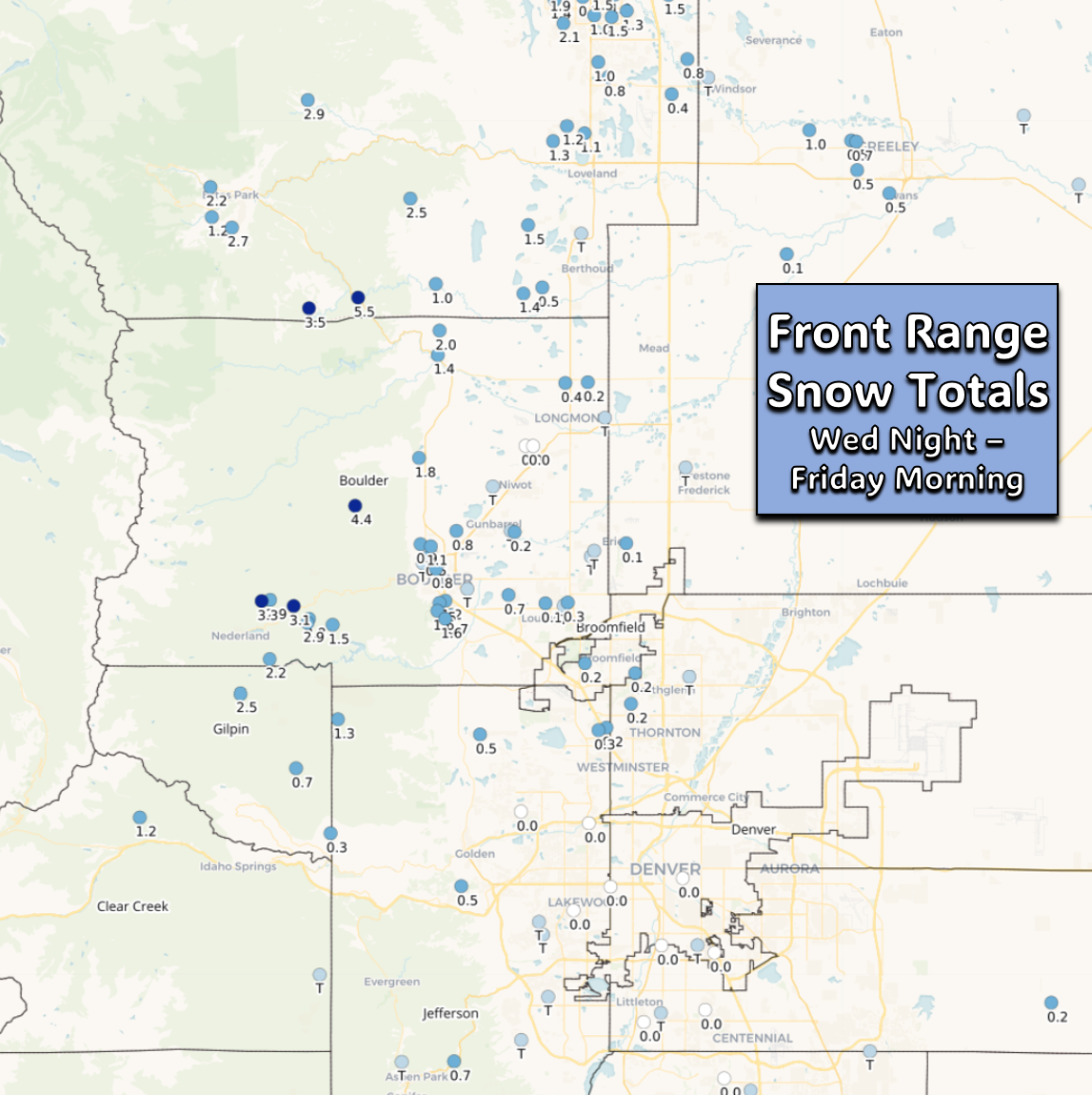
Up until yesterday, most of our area had seen little to no snow accumulation so far in April, but sporadic snow showers over the last 36 hours has changed that in many areas. Recent snow totals show that most of the Denver Metro area has seen a trace to an inch of spring snow in the last day or two. Higher amounts, up to 4″ have occurred in the nearby Foothills.
This unsettled, gloomy, and chilly pattern will continue for another day or two before we return back to beautiful spring conditions by Sunday. Between now and then, however, there’s an excellent chance of accumulating snow in our forecast area. After a gloomy day on Friday with periods of drizzle and some snowflakes, more intense and widespread snow is expected to develop Friday afternoon and evening, continuing through the overnight period. This snow event will be supported by several broader forcing mechanisms…
The first is surface upslope which will remain locked in across eastern Colorado through the day Friday into Saturday. This will help to lightly enhance precipitation rates, but also it will allow for the cold temperatures at the surface to keep most of the precipitation falling in the form of snow.
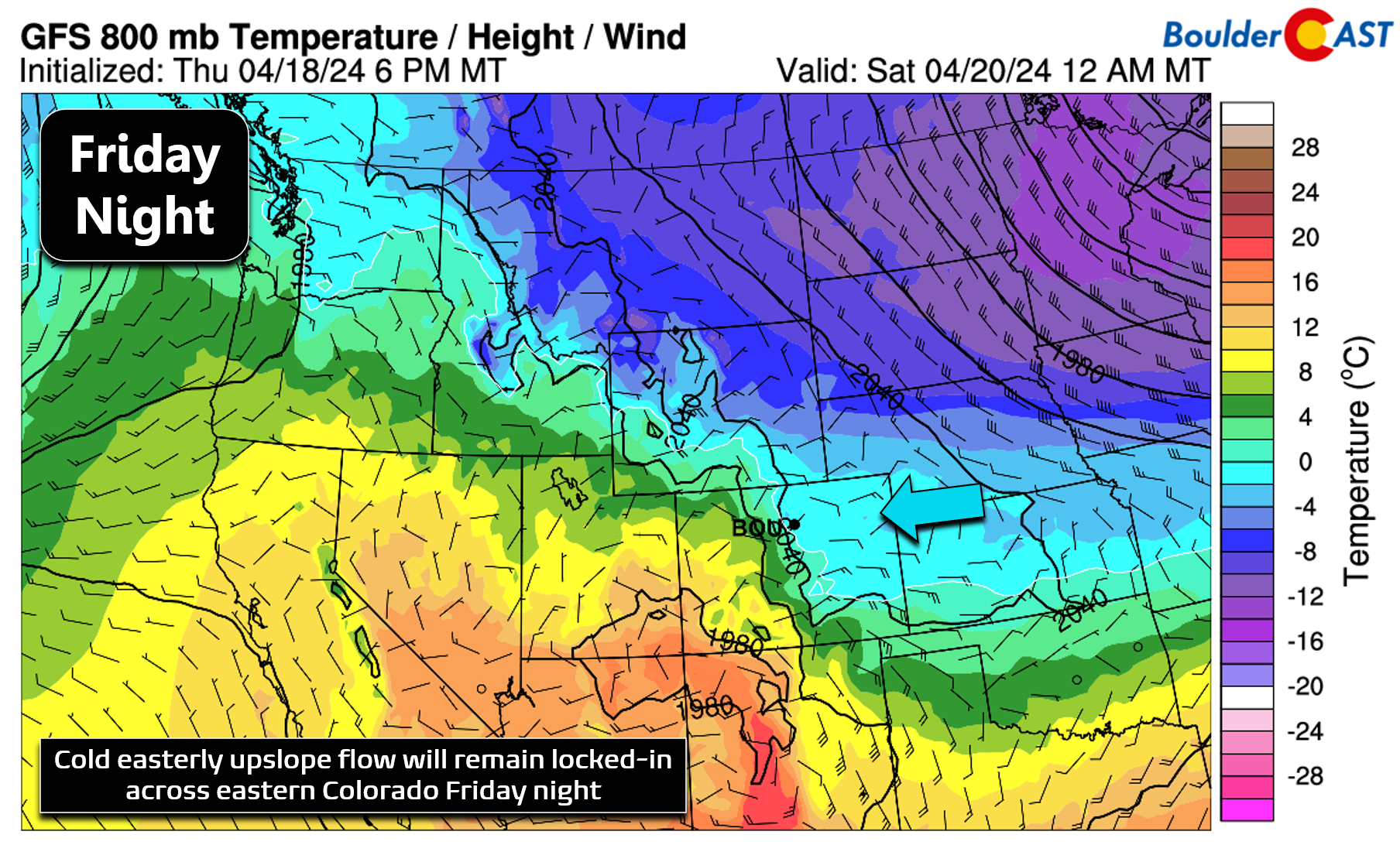
While that persistent upslope remains in place, the overhead jet stream will also come into play later Friday afternoon into Saturday morning. Northeast Colorado will end up in the favorable right-entrance region of a strong jet streak situated over the Midwest. However, at the same time, we will also be in the unfavorable left-entrance region of a different, weaker jet streak sitting further south. 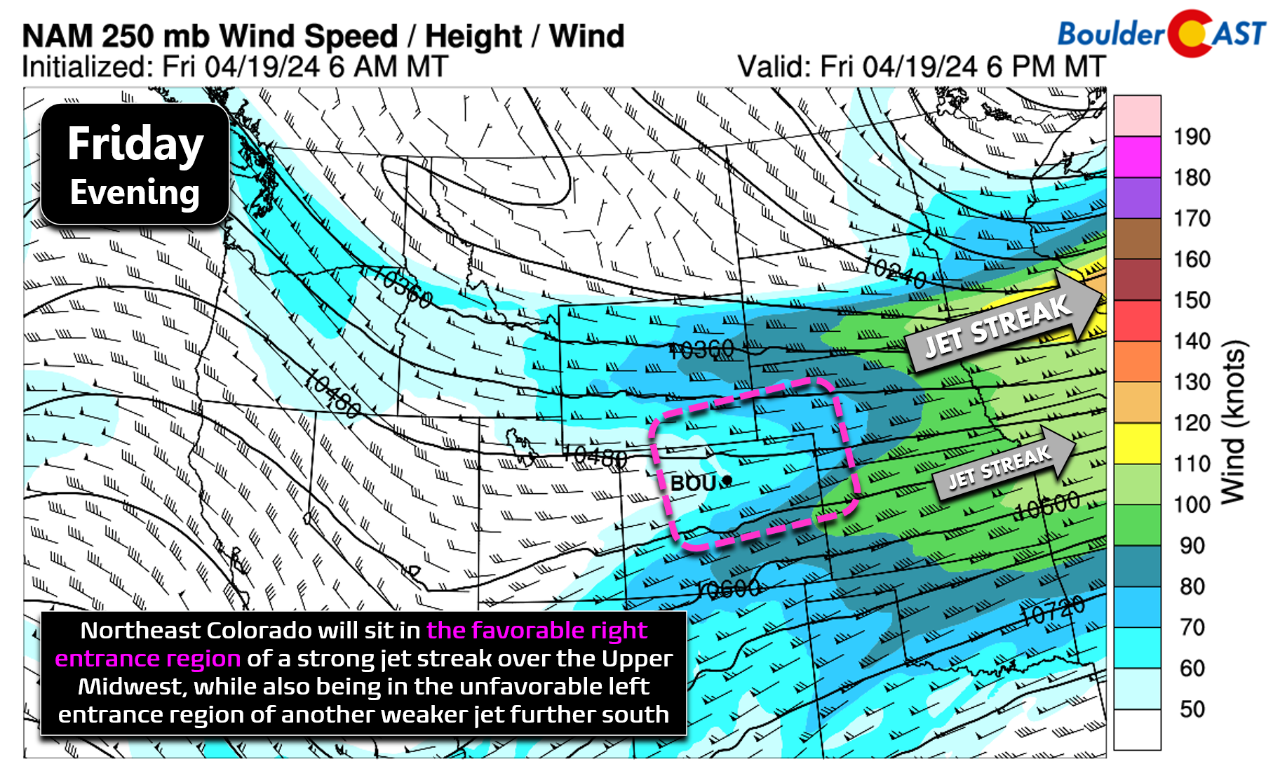
The concentrated lift generated by these two jet features will somewhat offset one another, but the favorable dynamics of the larger northern jet will win out it seems to provide a period of banded snowfall to the Front Range.
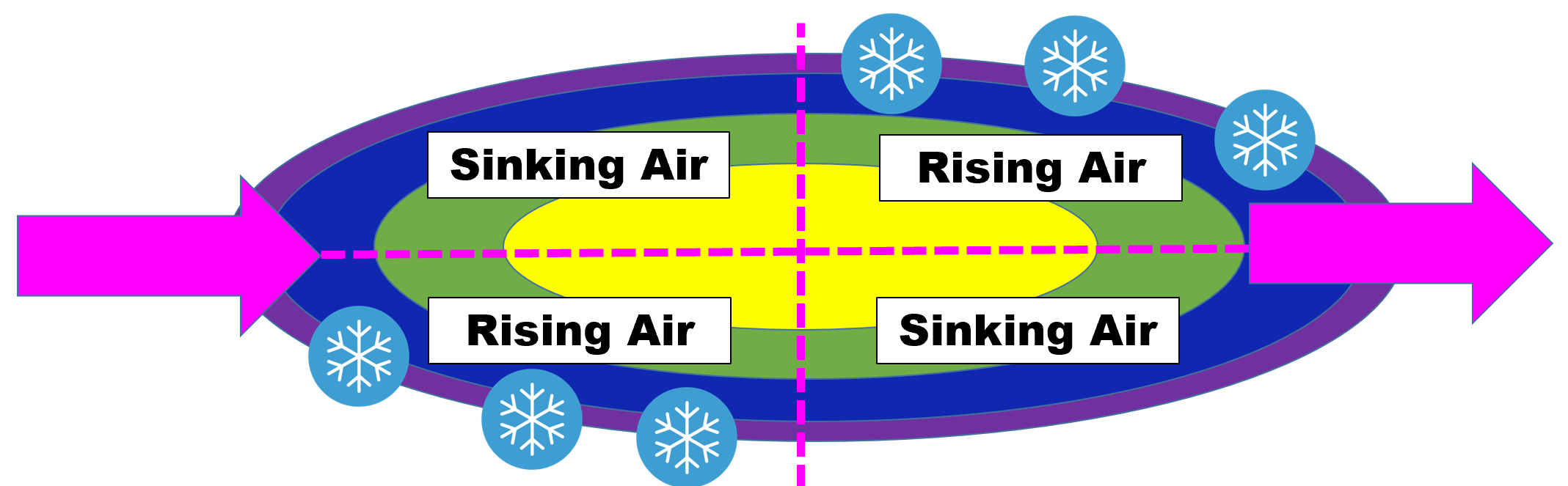
Idealized diagram of the quasi-geostrophic forcing imparted on the atmosphere by a jet streak.
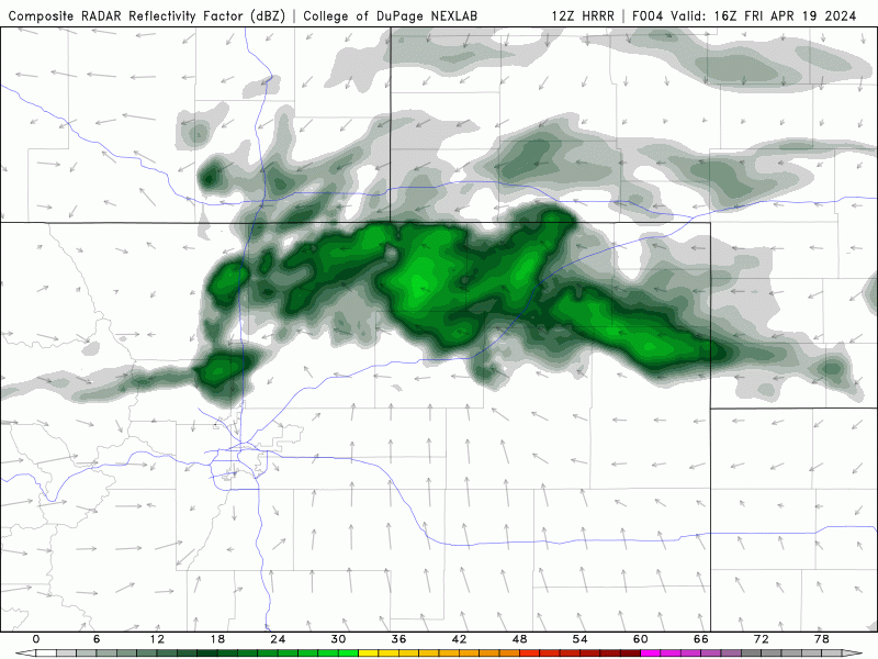
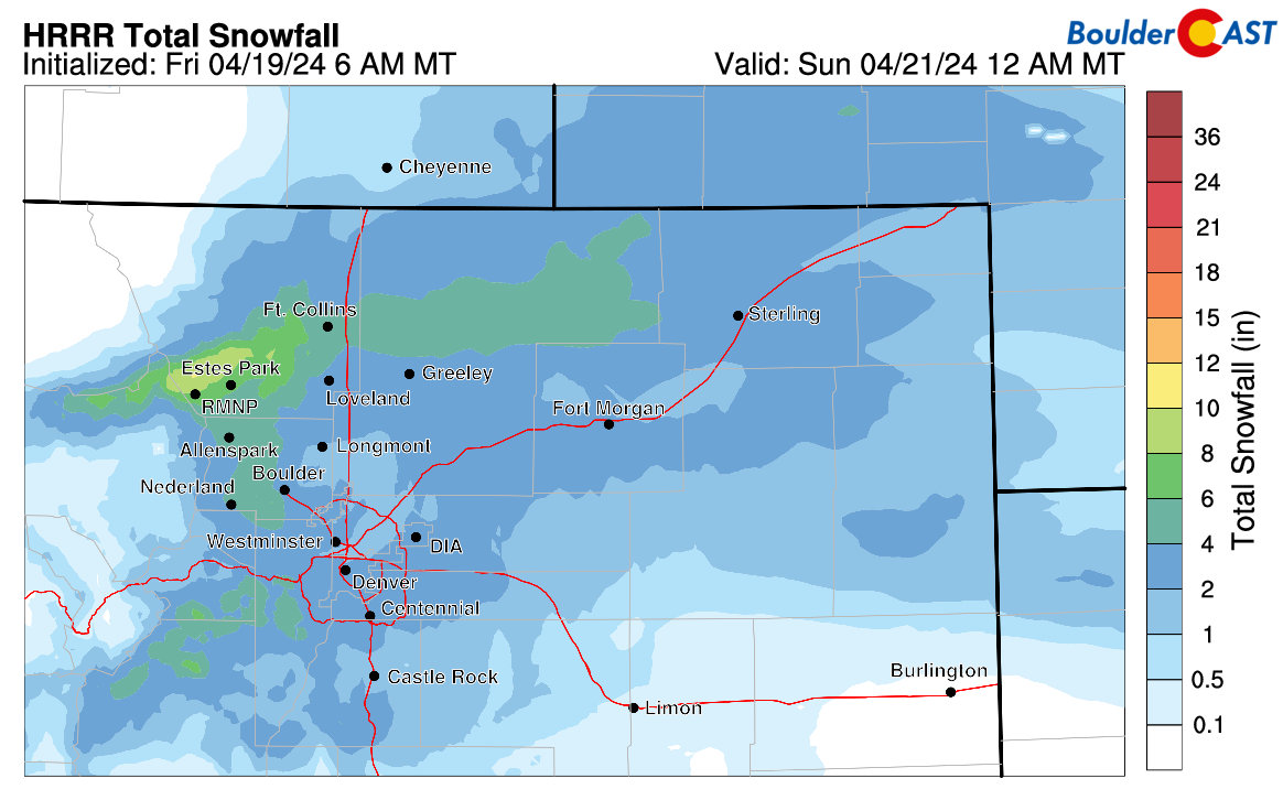
As always, banded snowfall can be challenging to forecast as the small-scale lift tends to greatly discriminate on which areas see heavy snow and which one largely miss out. The latest simulated radar forecast from the short-range HRRR model is shown below for the incoming event. Notice the explosion of snow bands expected Friday evening between Castle Rock and Cheyenne — all throughout the Boulder-Denver Metro area. The overall cluster of precipitation bands will be largely stationary over northeast Colorado for a fairly lengthy period of time — approximately from 3PM Friday to 9AM Saturday. However, as usual, the embedded bands in the broader cluster will be meandering and wobbling about, while also waxing and waning in intensity.
Models have remained very consistent on the overall placement of the cluster for days now, but exactly where the strongest and most persistent snow bands will hit remains murky at best. Global models show similar placement of the cluster, somewhere between Fort Collins and Castle Rock, but their output precipitation amounts are probably too high. For example, if the GFS verifies (below, bottom right), we’ll all be waking up to 5-10″ of snow Saturday morning! It’s not uncommon for the coarser resolution models to overshoot amounts for banded snow events, especially this time of year, as they fail to capture the small-scale nature of the bands and project them over too broad of an area.
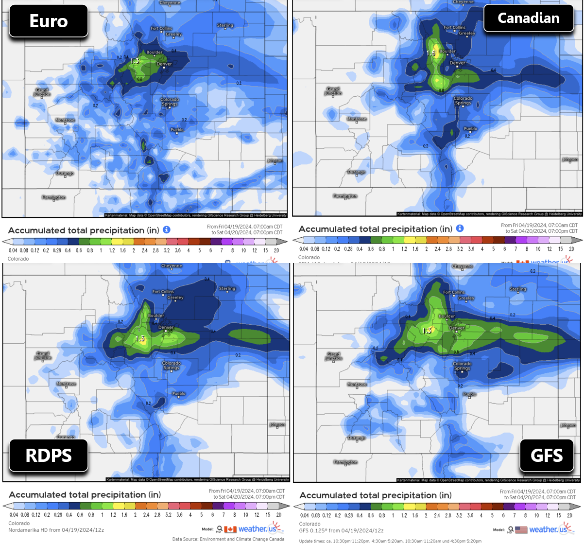
In times like these, we will always lean more heavily on the higher-resolution models. For example, the HRRR forecast radar animation we showed earlier results in a thin blanket of snow for most of the Denver Metro area and Foothills, with locally higher totals in the most persistent bands (forecast below). We can’t necessarily trust any specific bullseyes in this forecast below, but it does give us a good idea of how much snow to expect broadly (1-5″ for the entire area) and the realm of locally higher totals (>8″).
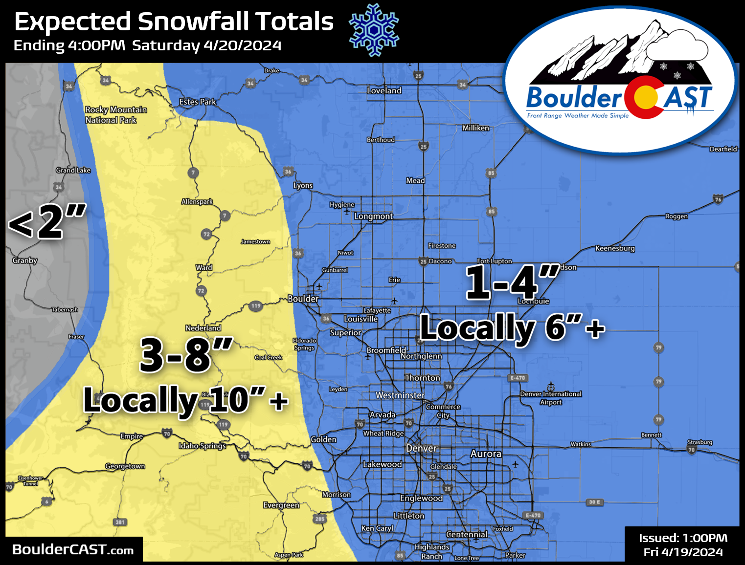
The official BoulderCAST snowfall forecast map for this late-April snow event is shown below. In general, most of the Metro area should pick up 1-4″ of wet spring snow by sunrise Saturday with locally higher totals over 6″. Foothills communities can expect 3-8″ with locally over 10″. Our trees still have limited foliage, but the early flowering trees could run into some issues Friday night in some areas if those 6″+ totals are realized across the lower elevations.
As far as the timing of things, banded precipitation is expected to quickly expand across the Front Range late Friday afternoon, beginning as rain or a very wet rain/snow mix. Temperatures will quickly drop with a full change-over to snow expected for everyone quickly in the evening. Snow, heavy at times, will then continue into early Saturday morning as temperatures drop down to the freezing mark . The near-perfect overnight (or at least low sun angle) timing of the snow will maximize the accumulation potential for this spring storm with less melting than if it had occurred during the day. Roads in the Foothills will likely become snow-covered, with slick travel conditions also possible across the Metro area, too. With road temperatures remaining near or above freezing, it will be more slush than ice down here — but nonetheless take it easy driving these next 18 hours or so! Snow will taper off through Saturday morning as the jet energy exits to the east. Saturday will remain gloomy and cold with most of the area likely stuck in the 30s to lower 40s through the day. Ugh! There is light at the end of the tunnel, though. Temperatures will warm back into the 60s by Sunday and into the 70s early next week.

Enjoy this quick and likely minor dump of late-season snow — it probably won’t be the last of the season for us just yet, but time will tell!
Get BoulderCAST updates delivered to your inbox:
Go Premium, get all the perks.
Daily Forecast Updates
Get our daily forecast discussion every morning delivered to your inbox.
All Our Model Data
Access to all our Colorado-centric high-resolution weather model graphics. Seriously — every one!
Ski & Hiking Forecasts
6-day forecasts for all the Colorado ski resorts, plus more than 120 hiking trails, including every 14er.
Smoke Forecasts
Wildfire smoke concentration predictions up to 72 hours into the future.
Exclusive Content
Weekend outlooks every Thursday, bonus storm updates, historical data and much more!
No Advertisements
Enjoy ad-free viewing on the entire site.
Enjoy our content? Help us out and give it a share:


You must be logged in to post a comment.