




Author: Ben Castellani (Page 127 of 358)
Ben grew up in southwestern Pennsylvania and holds both a bachelor's and a master's degree in Meteorology, the latter being from CU Boulder. His hometown received nearly three feet of snow from the Storm of the Century back in March of 1993, sparking his initial interest in impactful weather. Ben currently works on remote sensing and data analysis software at NV5 Geospatial Software in Boulder.

Much-needed light rain and snow showers fell across the area on Sunday, the first precipitation many of us have seen in over two weeks. The period ahead will unfortunately not continue that trend with mostly dry conditions and above normal temperatures expected to close out the month of April. We are watching a potential storm around the Friday timeframe. Once again it looks to offer wind and elevated fire danger, but sadly little in the way of precipitation. Read on for our full outlook of the weather week ahead.

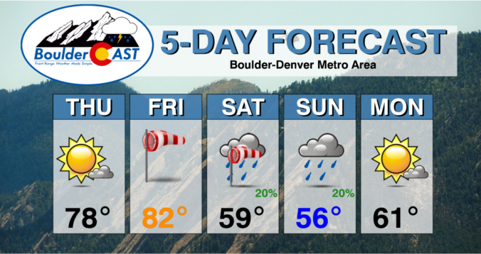
⦁❶⦁ Lesser fire concerns Thursday as winds relax and highs climb into the upper 70s under sunny skies
⦁❷⦁ A very strong storm will move across the Rockies on Friday creating a slew of weather impacts for the state — extreme fire danger, high winds, dust storms, mountain snow and severe thunderstorms
⦁❸⦁ WARNING: Extremely high fire danger Friday afternoon and evening with wind gusts 40+ MPH everywhere in the Front Range
⦁❹⦁ Cooler temperatures in the 50s with more clouds and a chance of rain showers both days this weekend


The last month has been very dry across the Denver Metro area with the progress we’ve made this year towards eradicating the drought starting to reverse. Wind and high fire danger have been rampant of late and that isn’t going to change this week, though it won’t be nearly as bad as recent times. Temperatures will be up and down through the days ahead, but prospects for any precipitation remain woefully slim.
Live Radar

Trending Content


Recent Premium Posts

This Weekend in Colorado Weather: The Quiet Pattern Ends as Storm Activity Picks Up Across the West
After weeks of sunshine, mild afternoons, and storm systems repeatedly missing Colorado to …
BoulderCAST Daily – Wed 11/11/26 | Mild Days Ahead, But There Are Signs of a More Active November Soon
☀️ Warm & Quiet — Sunshine dominates through Thursday with highs rising from …
BoulderCAST Daily – Tue 11/10/26 | Clouds Increase Today, But Colorado’s Dry Pattern Rolls On
🌤️ A Few More Clouds Today – Mountain wave clouds are developing along …
© 2026 Front Range Weather, LLC
You must be logged in to post a comment.