

Author: Ben Castellani (Page 126 of 358)

Ben grew up in southwestern Pennsylvania and holds both a bachelor's and a master's degree in Meteorology, the latter being from CU Boulder. His hometown received nearly three feet of snow from the Storm of the Century back in March of 1993, sparking his initial interest in impactful weather. Ben currently works on remote sensing and data analysis software at NV5 Geospatial Software in Boulder.

BoulderCAST Daily – Tue 05/10/22 | Mostly sunny & seasonal under a Denver Cyclone pattern; heat & fire danger return tomorrow

ADenver Cyclone setup will develop this afternoon keeping things on the cooler side for Boulder County, while areas further south and east will be warmer and windier. Recall that a Denver Cyclone forms when low-level winds from the southeast interact with the local terrain and form a counter-clockwise swirl of low pressure over the Denver Metro area. Watch the windy …

Weekend Weather Outlook: May 5, 2022

What a change of pace this week has been with a return to our normal rainy springtime weather. We've seen measurable precipitation each day this week in Boulder. Precipitation amounts have been good, but not great. Most areas have seen between 0.4" and 1.1" of moisture as shown in the graphic below. Unfortunately, that's where the good news ends on …

BoulderCAST Daily – Wed 05/04/22 | Cold, cloudy & showery today, the sun returns tomorrow

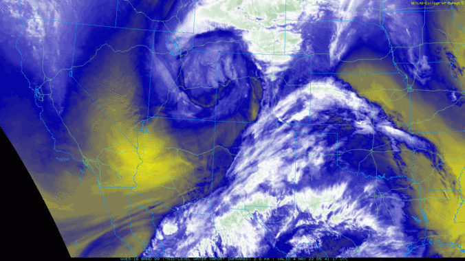
Water vapor satellite imagery from GOES-East shows the closed mid-level low pressure spinning across northwestern Colorado this morning. After a burst of moderate rainfall late yesterday evening, the Denver area got pulled into the dry slot during the overnight with mostly dry and overcast conditions prevailing. If you recall yesterday's post, we discussed a large variation in the track of …

BoulderCAST Daily – Tue 05/03/22 | Fog burns off to partly cloudy skies, another wet day tomorrow

Today will be a day of transition as the storm which brought beneficial rain and snow to the entire area on Monday heads east, while another potent low pressure is already gaining strength over Idaho. That secondary system has its focus set directly on Colorado --- it will be a sizable player for us later today through Wednesday night. Peeking …

Weekend Weather Outlook: April 28, 2022

The ridge of high pressure which has kept us warm and mostly dry the last few days has pushed off to the east with an axis now located over the heart of the Midwest. West of this ridge, southwest flow has been around since yesterday in our area with a stream of moisture funneling into Wyoming and northern Colorado right …

BoulderCAST Daily – Wed 04/27/22 | A warm & cloudy day with a small chance of sprinkles

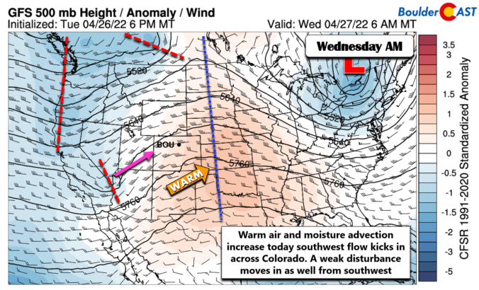
Amostly quiet day is on-tap for Front Range Colorado with a ridge axis very much nearby. The graphic below shows today's large-scale atmospheric setup. Since the ridge axis has passed to our east, southwest flow has kicked in across the Centennial State. This will allow for well above normal temperatures and will also advect in some moisture aloft (think lots …

BoulderCAST Daily – Tue 04/26/22 | Warming up as a ridge nestles into the area

Above normal temperatures return to the forecast today as an upper-level ridge slides into the area. The GOES-East infrared satellite animation below shows clear skies from Utah to Kentucky, with the ridge axis noted to be across western Colorado this morning. Today will be beautiful and warm with light afternoon breezes gusting 10-15 MPH. Expect lots of sunshine early, but …

« Older posts Newer posts »