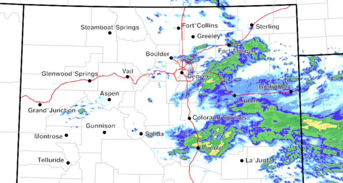
Rain is spreading across eastern Colorado this morning, with a broad, soggy setup still on track to bring rain and high‑elevation snow through the day to the Front Range. However, a continued southward shift in the storm track means precipitation totals around Denver and Boulder will likely fall short of earlier expectations. Nonetheless, a cool, gloomy day with plenty of showers still lies ahead, along with accumulating snow in the Foothills. Here’s the latest.
This content is for BoulderCAST Premium members only. Join Premium now to get access to our detailed forecast discussions for Boulder and Denver every single day, plus a bunch of other cool perks!

Go Premium, get all the perks.
Daily Forecast Updates
Get our daily forecast discussion every morning delivered to your inbox.
All Our Model Data
Access to all our Colorado-centric high-resolution weather model graphics. Seriously — every one!
Ski & Hiking Forecasts
6-day forecasts for all the Colorado ski resorts, plus more than 120 hiking trails, including every 14er.
Smoke Forecasts
Wildfire smoke concentration predictions up to 72 hours into the future.
Exclusive Content
Weekend outlooks every Thursday, bonus storm updates, historical data and much more!
No Advertisements
Enjoy ad-free viewing on the entire site.


You must be logged in to post a comment.