Author: Ben Castellani (Page 105 of 301)
Ben grew up in southwestern Pennsylvania and holds both a bachelor's and a master's degree in Meteorology, the latter being from CU Boulder. His hometown received nearly three feet of snow from the Storm of the Century back in March of 1993, sparking his initial interest in impactful weather. Ben currently works on remote sensing and data analysis software at NV5 Geospatial Software in Boulder.
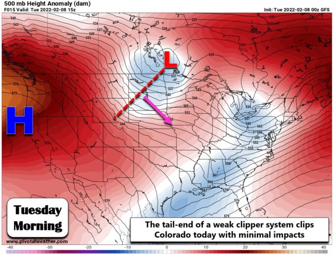

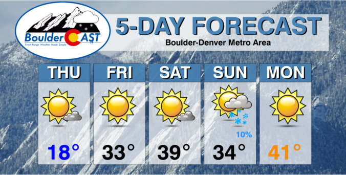
After one of the snowiest mid-winter stretches in Boulder’s history, it appears that things will quiet down somewhat for the week ahead. Temperatures will be fairly mild through the week. However, there will be several disturbances to watch which could produce snow across the Front Range — one Wednesday night with another to follow late Friday. Read on for our complete outlook for the week ahead.
As of Wednesday morning, the heaviest snow is now behind us, but this snowstorm is not completely over and done with yet. We review the snow totals so far, discuss how much more to expect through the day, and take a look at what is shaping up to be the coldest night of the season ahead.


A slow-moving winter storm will impact the Front Range Tuesday through Thursday bringing accumulating snow and bitter cold temperatures to the entire area. We expect the most snow to fall in the city of Boulder and nearby Foothills with lower amounts in Denver. Nonetheless, travel impacts will be widespread and temperatures will bottom out below zero as the storm pulls away on Thursday. Let’s talk timing and look at our snowfall forecast map.
Premium Storm Update (2/1/22 7:00AM): Overnight model runs have increased our confidence that higher-end snow totals will occur with this system. Thus we are bumping up snow amounts a tad across the area. We discuss the model changes and some things that still need to be watched closely as the snow begins Tuesday afternoon. READ HERE
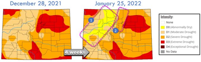
Adding in the few inches that fell on Thursday, Boulder has now notched nearly two feet of snowfall in the month of January, the most since 2014. This recent snow event was just one of many small winter storms to impact the Front Range in the weeks following the devastating Marshall Fire. Colorado has seen slight drought improvement, but there is definitely much more needed. In this update we discuss the recent snow totals, how January as a whole is shaping up, the locations that are seeing drought conditions improve, why La Niña will make further recovery more challenging and much more.

Live View of Boulder

Current Conditions

Live Radar

Recent Premium Posts

BoulderCAST Daily – Tue 04/28/26 | Staying cool with a couple showers, the late-week storm is still the main event despite trending south
🌧️ Morning wave = main show, with light rain showers and Foothills wet …
BoulderCAST Daily – Sun 04/26/26 | Showers and some storms later today and this evening
🌧️ A wet afternoon and early evening, with showers and a few rumbles …
BoulderCAST Daily – Sat 04/25/26 | Cooler today and wet Sunday into early next week
🌧️ A wet latter part of the weekend, with showers and a few …
3-Day Forecast

Trending Content

© 2026 Front Range Weather, LLC