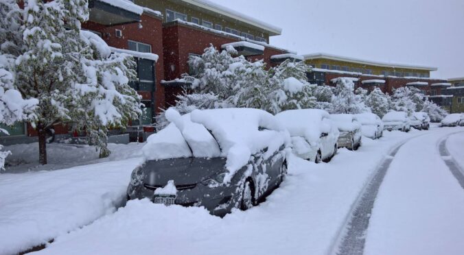
A slow-moving winter storm will impact the Front Range Tuesday through Thursday bringing accumulating snow and bitter cold temperatures to the entire area. We expect the most snow to fall in the city of Boulder and nearby Foothills with lower amounts in Denver. Nonetheless, travel impacts will be widespread and temperatures will bottom out below zero as the storm pulls away on Thursday. Let’s talk timing and look at our snowfall forecast map.
Premium Storm Update (2/1/22 7:00AM): Overnight model runs have increased our confidence that higher-end snow totals will occur with this system. Thus we are bumping up snow amounts a tad across the area. We discuss the model changes and some things that still need to be watched closely as the snow begins Tuesday afternoon. READ HERE
At a Glance:
- A bitter cold and slow-moving winter storm will impact the Front Range Tuesday through Thursday
- Look for snow to begin by the afternoon Tuesday and then continue fairly steadily into Wednesday evening
- Snowfall rates will be generally light, but some moderate snow possible particularly Tuesday night into early Wednesday
- Snow tapers off Wednesday evening with skies clearing — temperatures will likely drop below zero everywhere by sunrise Thursday
- The diciest commute will be Wednesday morning — plan on a slow-go and snowy roads!
- Snowfall totals of 7-14″ in Boulder and the Foothills, but 3-8″ in Denver (lowest east and southeast)
We discuss Boulder and Denver weather every single day on BoulderCAST Premium. Sign up today to get access to our daily forecast discussions every morning, complete six-day skiing and hiking forecasts powered by machine learning, access to all our Front Range specific weather models, additional storm updates and much more!

A
s we have been discussing for the last several days, we are bracing for a prolonged period of snowfall across the Front Range Tuesday afternoon lasting all the way into Wednesday night. Accompanying the snow will be very cold temperatures as an Arctic airmass dips southward into Colorado. This is possibly the coldest air of the season so far, though it will be close to what we endured back in the first week of 2022.
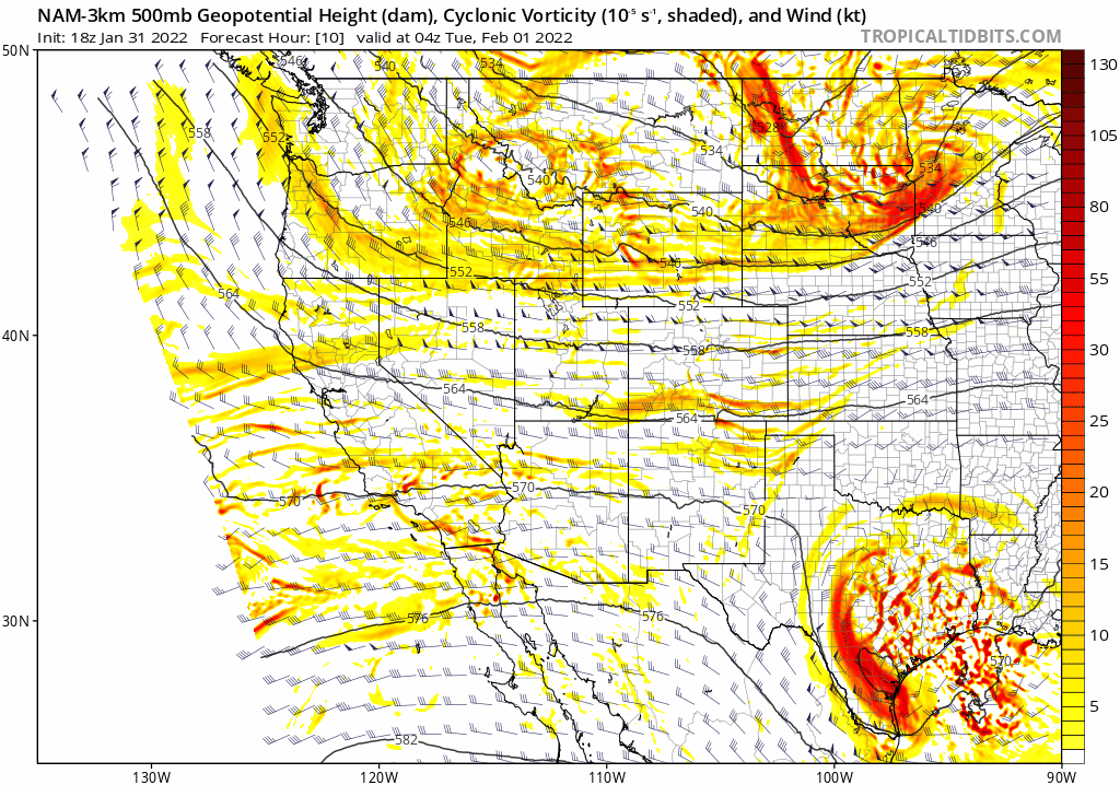
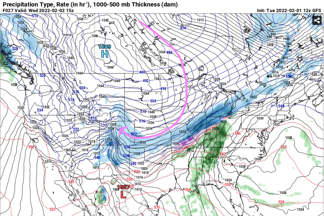
Finally, we have a broad and decent storm system tracking across the Rockies with an overall sluggish progression. It digs south on Tuesday and then treks eastward Wednesday into Wednesday night. This setup puts most of Colorado in a favorable location for large-scale lift for a lengthy period, some 24 to 36 hours, as the trough pivots across the Great Basin and Four Corners area.
In addition to the moderate lift introduced from the trough moving through, some type of upslope will be present the entire time across the Denver Metro area lending to high confidence in at least moderate snowfall amounts. Initially this looked to be one heck of an upslope storm for particularly Boulder with favorable easterly flow projected for a very long time, but models have shifted wind directions a bit so we are expecting slightly lower totals overall. Nonetheless, we’re still talking several inches of snow for everyone in the Front Range, with some areas possibly getting close to a foot of fluff by the time things wrap-up late Wednesday night!
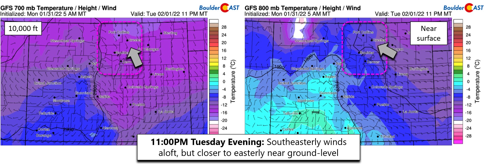
Here’s a look at the wind and temperature forecast from the GFS model for Tuesday evening. Near the surface, winds are east-southeasterly. Up at 10,000 feet elevation, they are closer to southerly. This wind direction out of the southeast, instead of the east, will favor Boulder and Larimer Counties for light to moderate snowfall Tuesday night into early Wednesday under the best upslope. This direction is not very good for east and southern Denver as it induces some downslope off the Palmer Divide. Parker and Aurora won’t see that much snow at all from this event. Neither will DIA.
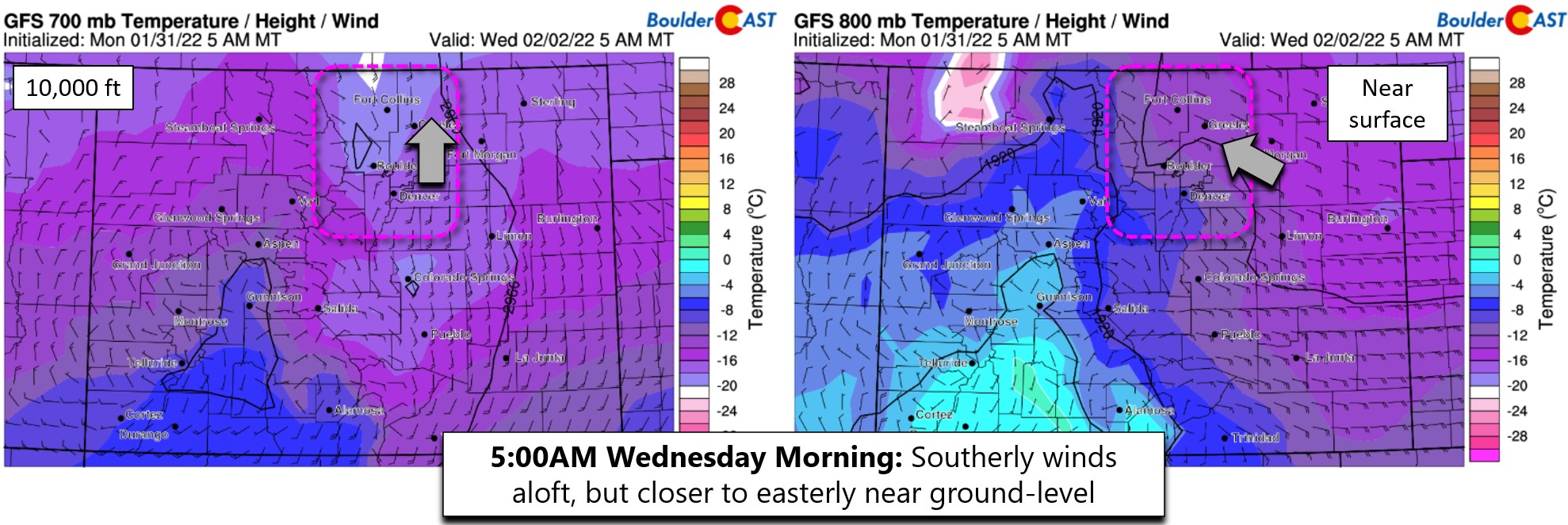
Very little changes in the winds by Wednesday morning so expect light snow to continue during this period. Actually almost identical flow continues all the way into Wednesday evening before a final surge of dry Arctic air brings precipitation to an end from north to south.
Why is the upslope so….southeasterly? Well, the upslope for this event is actually being forced more so by high pressure, as opposed to the normal low pressure. The clockwise flow around the huge 1050 millibar Arctic high in Canada is what’s causing the southeasterly winds in the Denver area!
GFS pressure and precipitation forecast for Wednesday morning. The expansive Arctic high in Canada is forcing our upslope!
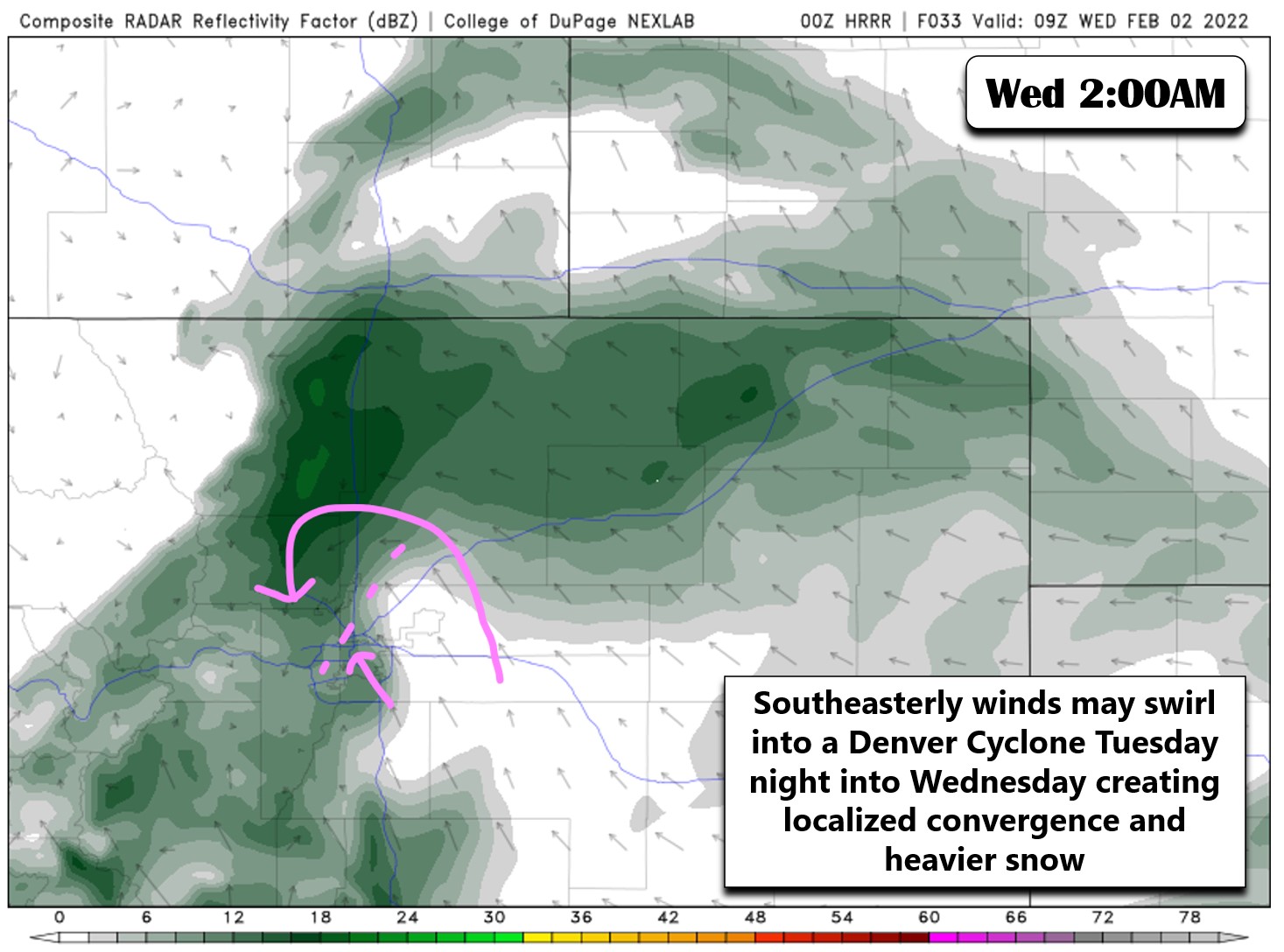
One thing we will need to watch closely with the southeasterly winds will be the potential for the terrain to induce a Denver Cyclone during the event. These swirling winds have been known to create localized convergence in the Metro area leading to pockets of heavy snow, usually north and northwest of Denver towards Boulder. The high-resolution HRRR model is just starting to zero-in on this storm and it’s already showing the potential turning and converging winds late Tuesday night. The model shows something similar again during the day Wednesday — this is something to watch closely!
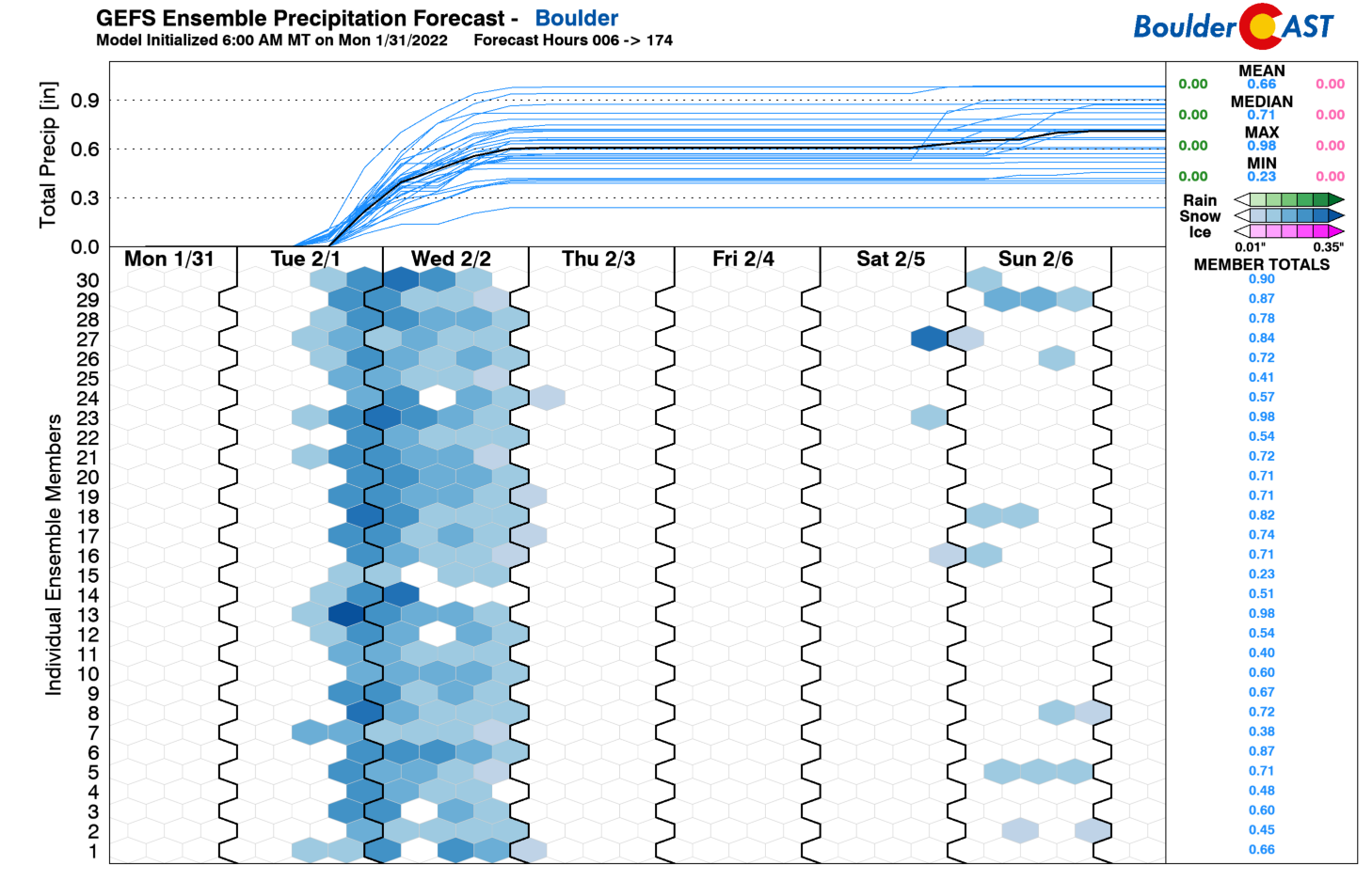
Models remain very consistent with this storm in terms of moisture potential. The GFS, Euro and NAM models indicate around 0.6″ in Boulder, with a little more than half that amount in Denver.
The GFS ensembles are clustered nicely around this 0.6″ amount as well in Boulder, though there is certainly some variance both wetter and drier. With a 15:1 snow ratio, that’s going to add up to about 9″ in the city.
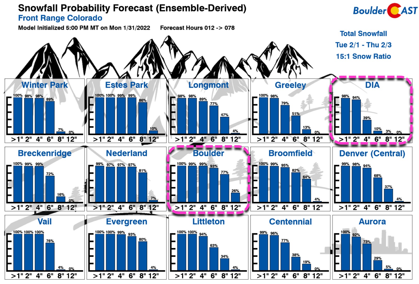
Our Snowfall Probabilities match our thinking that the heaviest snow from this setup will fall in Boulder and Larimer Counties — southeasterly flow reigns king in this area. Boulder, for example, has about >90% chance to see more than 6″ of snow, and a 26% chance to exceed 12″. On the other end of things, Denver International Airport only has a 39% chance to see 4″ of snow. Our probabilities clearly indicate the focus will be in the west and northwest suburbs and Foothills.
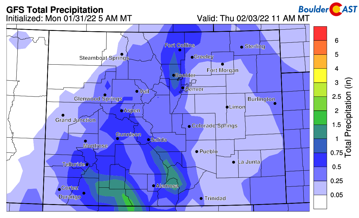
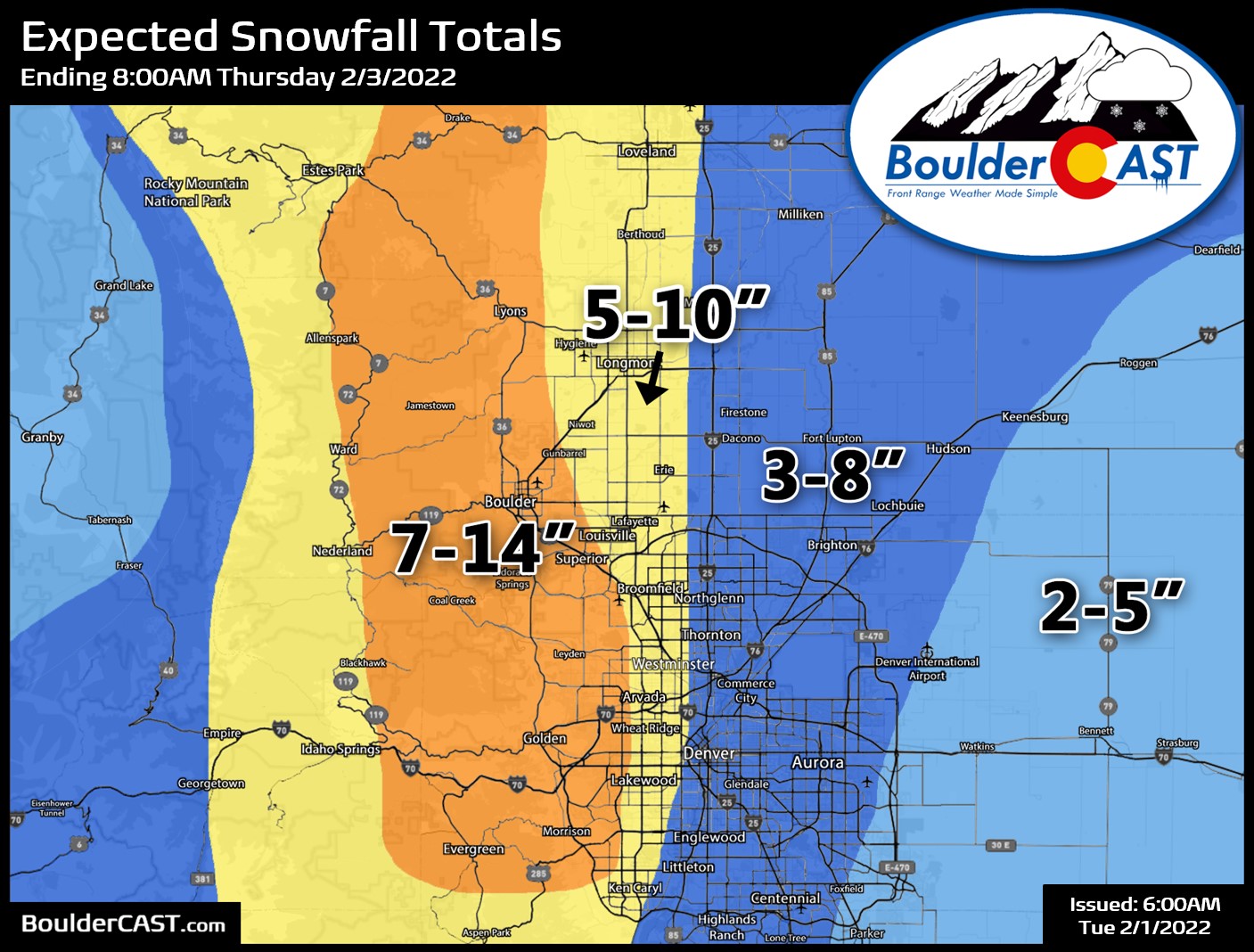
Our snowfall forecast map for the event is shown below (Updated 6:00AM Tue 2/1/22). This covers all snow falling Tuesday into Wednesday night. The heaviest snowfall from this event will be focus in and near the Foothills of Boulder, Jefferson and Larimer Counties. Much lower totals are anticipated east and southeast of Denver for reasons already discussed.
TIMING
Expect snow to begin Tuesday afternoon or early evening across the Front Range increasing in coverage during the evening and overnight. There could be pockets of heavier snow during the Tuesday overnight period, aided by both the nearby jet stream and that potential Denver Cyclone convergence touched on earlier. Snow will continue off and on through the day Wednesday before finally coming to an end Wednesday evening from north to south.
TRAVEL IMPACTS
There might be some light snow around for the Tuesday PM commute in spots, but roads should be mostly fine but becoming slick through the evening. The Wednesday AM commute is our biggest concern right now with snow-covered roadways likely for the entire area, especially around Boulder. Light snow will likely be falling for the Wednesday PM commute as well, though there is some uncertainty on when the snow may wrap up.
FINAL WORD
Be sure to check back with us early Tuesday. If the morning model runs warrant it, we may be adjusting our snowfall forecast map. Enjoy the Arctic blast!
Get BoulderCAST updates delivered to your inbox:
Help support our team of Front Range weather bloggers by joining BoulderCAST Premium. We talk Boulder and Denver weather every single day. Sign up now to get access to our daily forecast discussions each morning, complete six-day skiing and hiking forecasts powered by machine learning, first-class access to all our Colorado-centric high-resolution weather graphics, bonus storm updates and much more! Or not, we just appreciate your readership!
Enjoy our content? Give it a share!


You must be logged in to post a comment.