The final day of what has been a snowy January will be quiet across the Front Range, but that all changes for the start of February as a significant winter storm takes aim on the region. Upslope favored areas like Boulder could very well see close to a foot of snow this week while parts of Denver will see much less. Some of the coldest air of the season will be moving in as well. We give our current thoughts on the incoming storm and our preliminary snowfall expectations. Quiet weather returns late in the week and for the upcoming weekend.
This week’s highlights include:
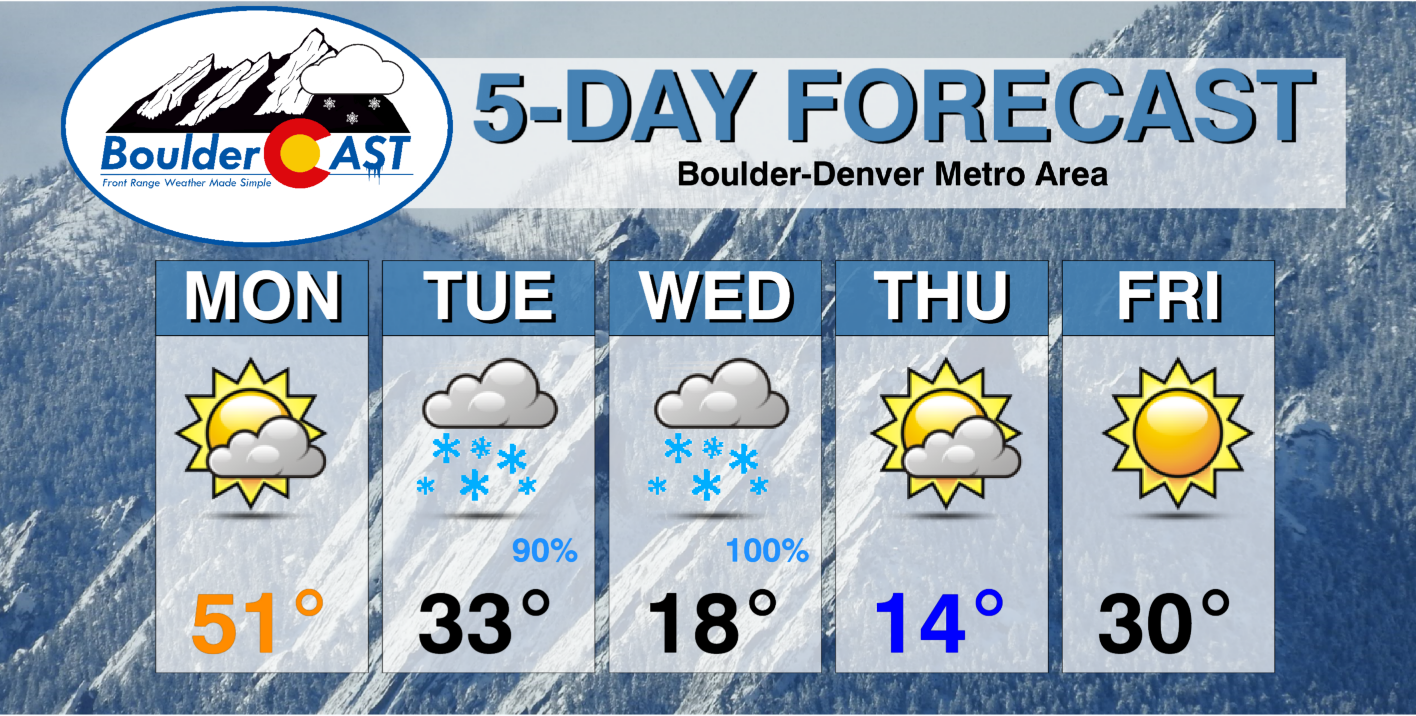
- Highs again in the 50s Monday ahead of a cold front in the evening
- A slow-moving winter storm overtakes the region Tuesday afternoon and lingers into Wednesday night
- Confidence for significant snow is increasing, with up to a foot possible in and near the Foothills — we predict Phil the Groundhog is not going to see his shadow 🙂
- Very cold and anomalous Arctic air will accompany the storm — multiple days with highs in the teens and sub-zero lows likely on the backend
- Quiet weather but still below average temperatures will close out the week
DISCLAIMER: This weekly outlook forecast is created Monday morning and covers the entire upcoming week. Accuracy will decrease as the week progresses as this post is NOT updated. To receive daily updated forecasts from our team, among many other perks, subscribe to BoulderCAST Premium.

Quiet and mild to start
Quiet weather starts our week, largely leaving right where we left off from the weekend. The atmosphere is not “quiet”, though. We have a cut-off low in central Texas, a trough over the Carolinas, and a more significant system to our northwest in Montana. This system will track into the Dakotas and Minnesota over the next 24 to 36 hours and then into Canada. An associated cold front will pass through our area later Monday evening ushering in the first batch of colder air.
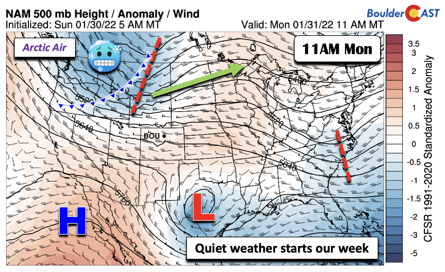
Highs will be in the lower to middle 50s once again across the area on Monday, with even some upper 50s in southeast Denver. With the trough to our north, a jet streak will be moving through the state. The jet being oriented perpendicular to the mountains should lead to periods of wave cloudiness during the day across the Front Range. The first cold front will move through tonight (below), but the truly Arctic air will filter in Tuesday night into Wednesday.

Confidence for a significant winter storm through Groundhog day is increasing
The weather turns drastically different on Tuesday. A significant winter storm is very likely for portions of the Front Range, largely zeroing in on Boulder more so than Denver. The trend in the models the last few days has been towards a long-duration upslope event, a situation that usually favors Boulder and areas closer to the Foothills. Nevertheless, everyone is going to see snow when all is said and done by the time storm moves out on Thursday.
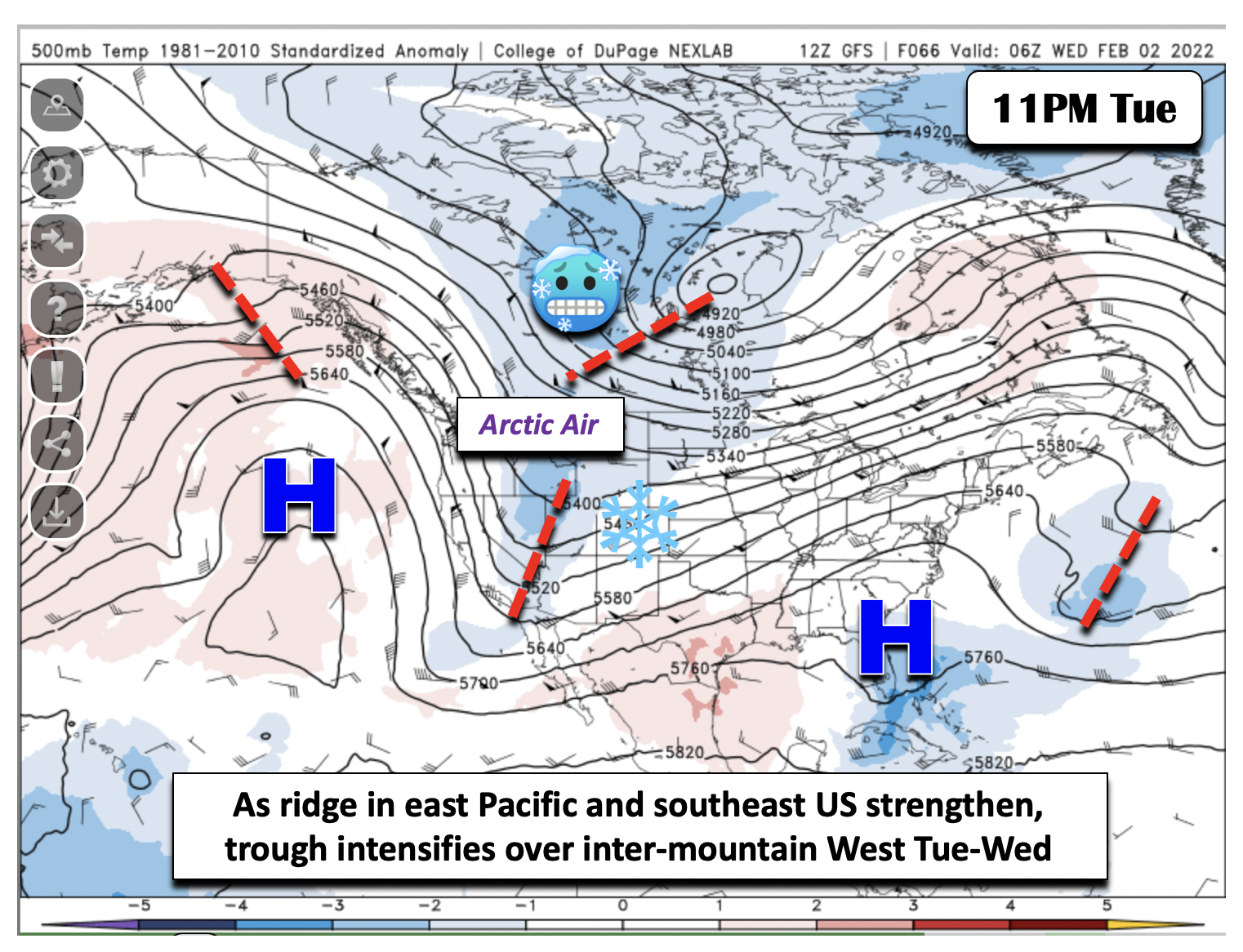
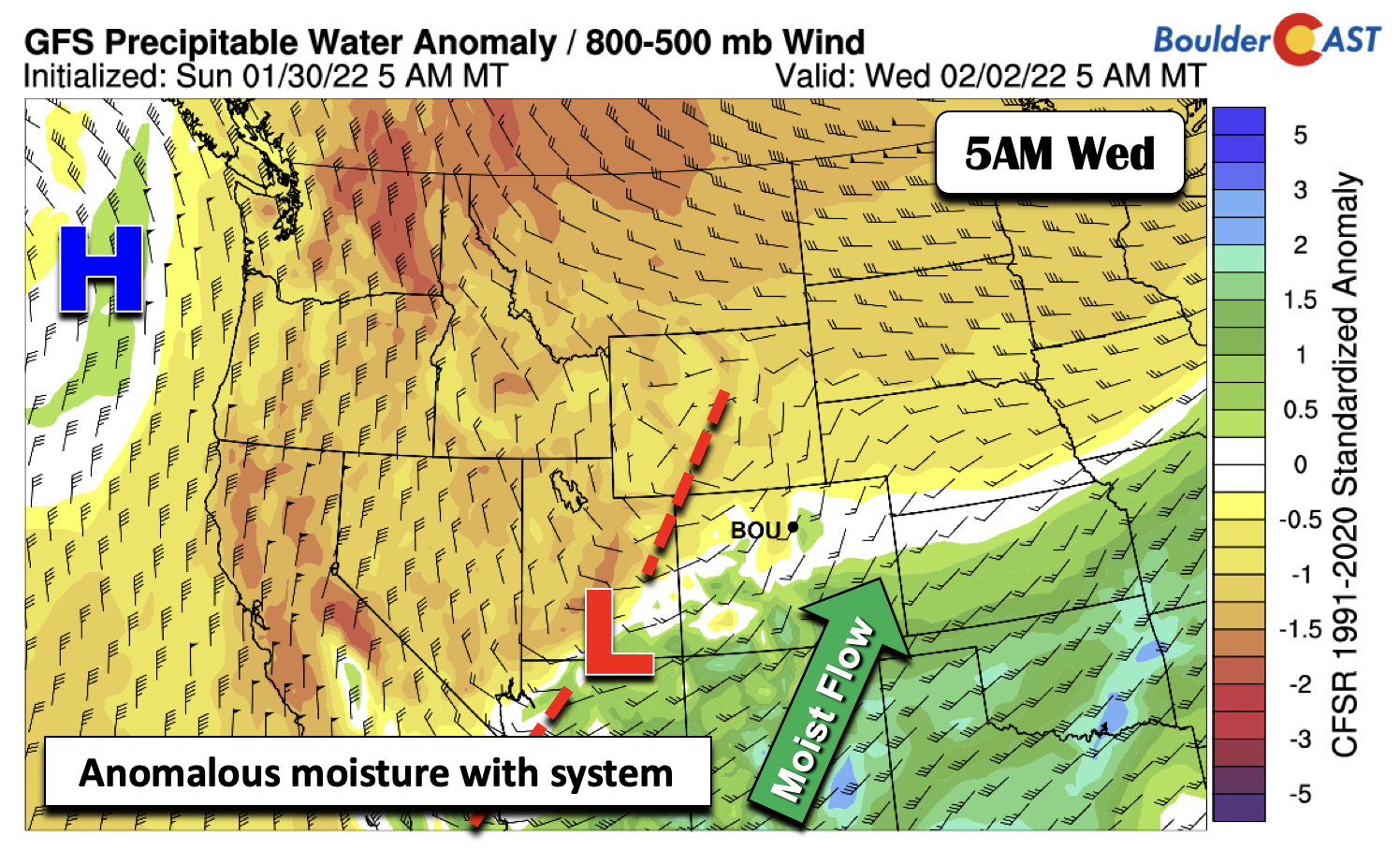
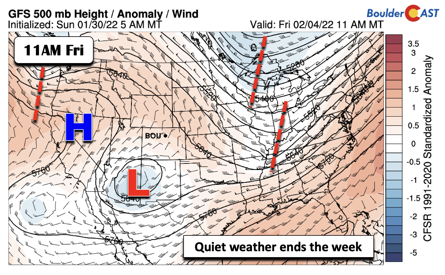
The image below shows the synoptic setup for the storm. As high pressure strengthens and moves into the northeast Pacific on Tuesday, the floodgates will open to allow Arctic air from northern Canada to ooze into Colorado Tuesday through Wednesday. A trough of low pressure will form at mid-levels near southeastern Nevada and southwest Utah. At the same time, high pressure at mid-levels over the southeast US will promote a slow eastward progression of the trough and allow it to intensify as it tracks across Colorado late Tuesday through early Thursday. This will be our snowstorm!
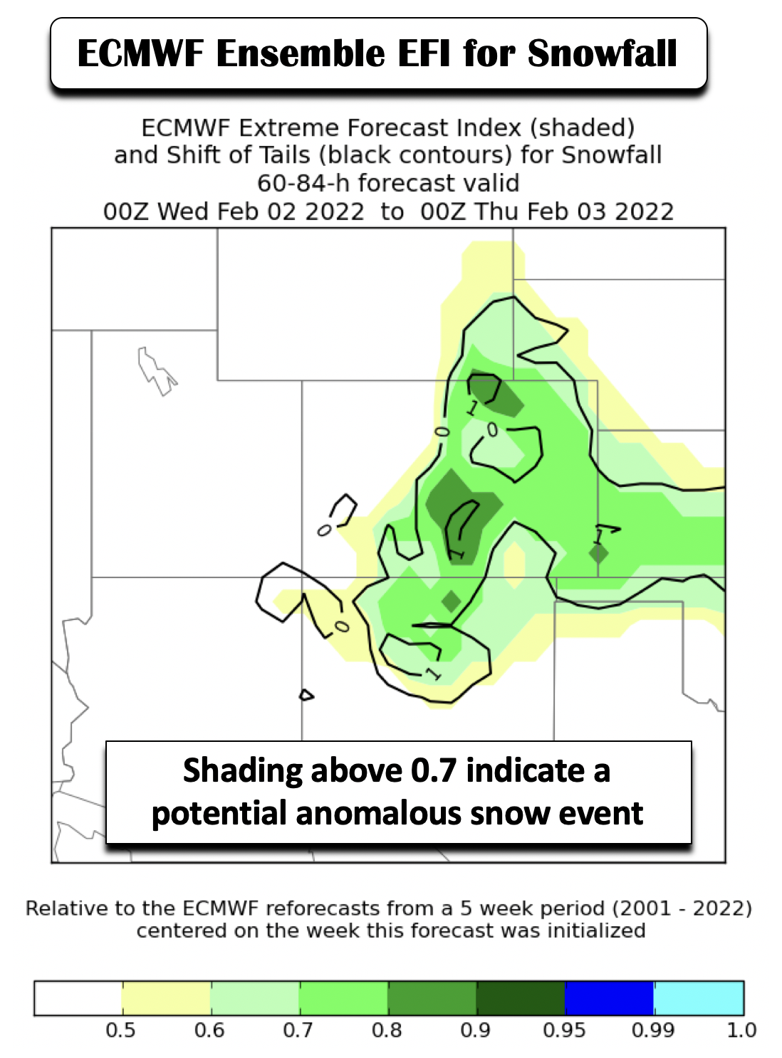
We have been tracking this snow storm since Friday, with hints of it showing up in the ensembles of the GFS and ECMWF models. A new product from NOAA offers a simplified way of interpreting output from all members of the Euro ensemble by allowing us to hone in on significant weather patterns. The tool is an extreme forecast index (EFI) designed to highlight areas of anomalous to potentially extreme events that might happen, shown below for snowfall in the Tuesday night through Wednesday period over Colorado. To interpret this, the shading indicates the potential for anomalous snowfall — areas above about 0.7 highlight that many ECMWF members are predicting an anomalous snow event (relative to the ECMWF model climatology). The black lines indicate the potential for an extreme snow event — values above about 2 or 3 are worth investigating. In this case, the black contours do not exceed 1, so while not expected to be extreme event, this will likely be anomalous for the Front Range.
The trough on Tuesday will form over southwest Utah and track east-southeast into Texas, but progress very slowly over a 24-36 hour timeframe. This will promote a long duration period of upslope for the Boulder-Denver area, initiating Tuesday afternoon or evening.

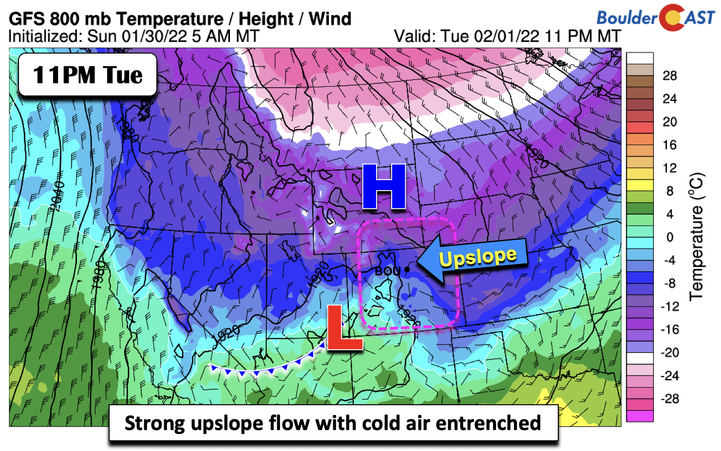
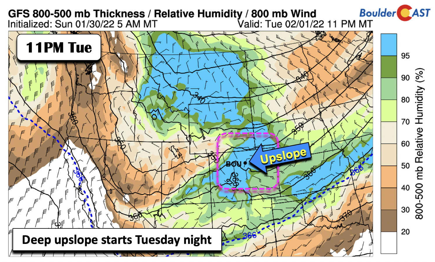
The cold air will be entrenched on Tuesday, continuing to filter in as the day progresses. Highs will only top out in the lower 30s, with temperatures falling into the teens by early Wednesday with a secondary surge of Arctic air. Strong low-level upslope will develop Tuesday night (below) as a surface Arctic high settles over Wyoming and low pressure over the Four Corners develops in response to the mid-level trough. The models are starting to hone in on a commencement time for the snow around rush hour Tuesday night.
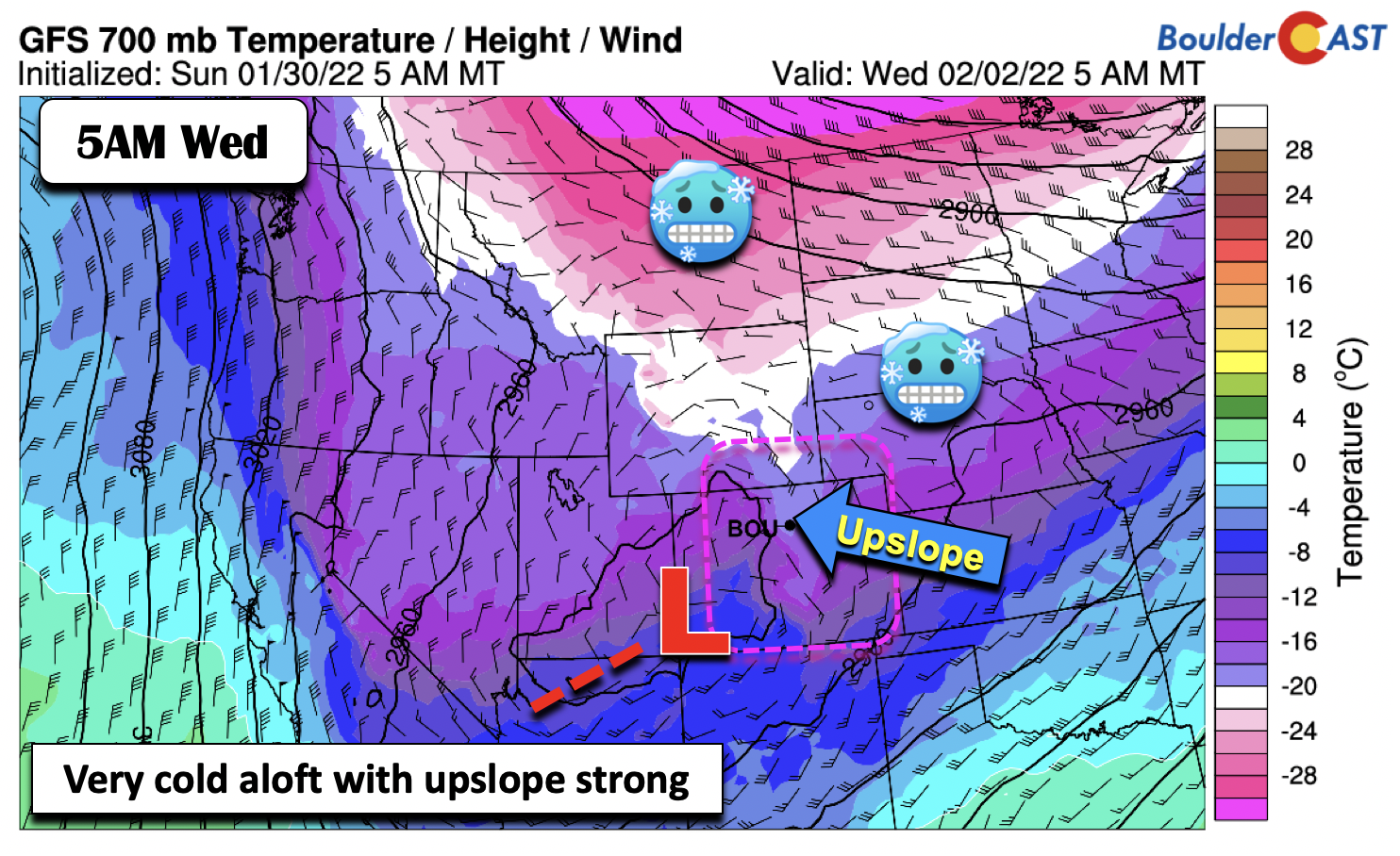
Along with the surface upslope, deeper upslope will be found aloft, with the image below showing a forecast for 5000 feet above the surface. Very cold air will be in place, some of the coldest we have seen this winter with temperatures below -18°C.
The GFS sounding for Boulder shows the temperature and dewpoint pattern for Tuesday night. On the right of the figure, the winds are denoted by barbs, showing upslope extending to about 8000 feet up from the surface, with a deeply saturated layer of ice crystal growth. The dendritic snow growth region is just off the surface this time around, a consequence of the Arctic airmass in place.
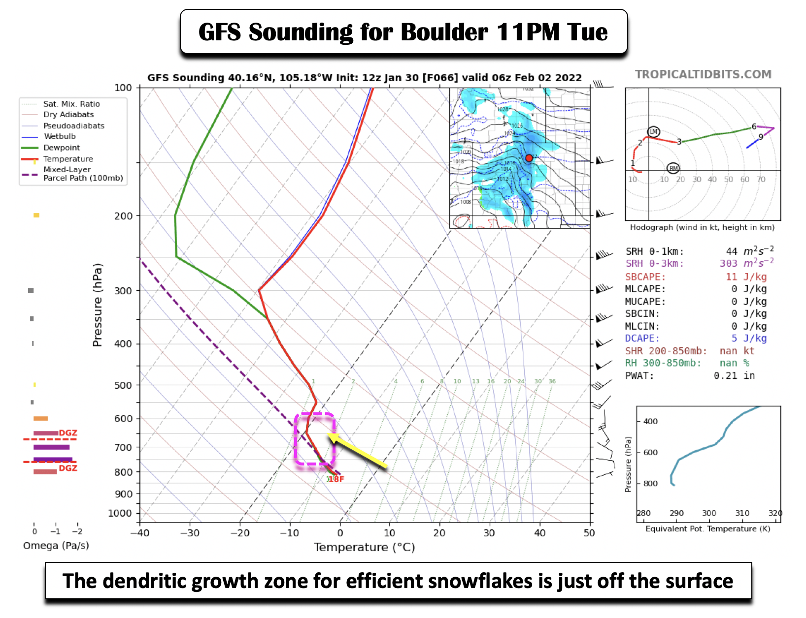
The very cold air will favor high snow-to-liquid ratios (SLRs) for the duration of the event. With the exception of the onset Tuesday night where SLRs could be around 14:1, SLRs should be above 17:1 thereafter.

To follow-up on the nature of this system being a long-duration upslope event, the next three figures show the progression of the upslope. Deep upslope starts Tuesday night (below).
The upslope persists through Wednesday (below).

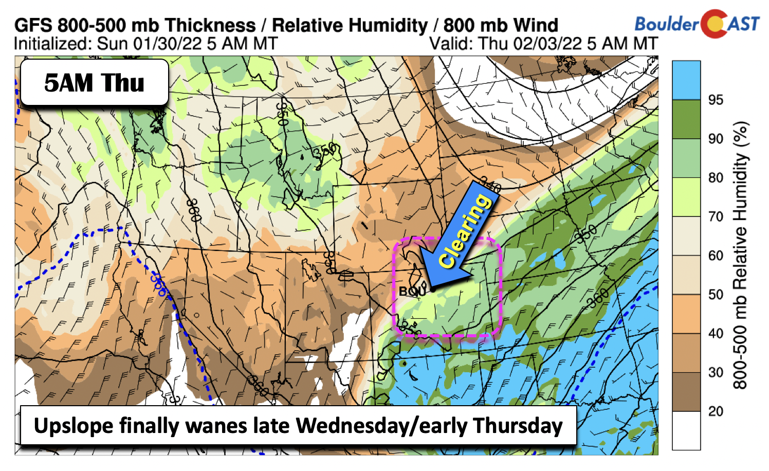
The upslope finally tapers off late Wednesday night as the system tracks east and out of the area (below).
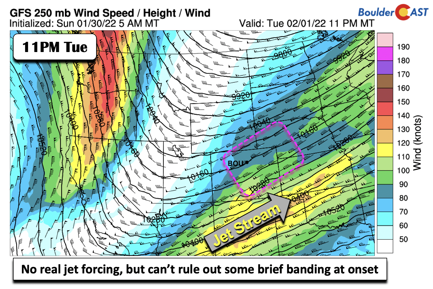
While we can’t rule out some brief snow banding with the storm, primarily at the onset, this system will largely be void of jet forcing. The main lift will be from the long-duration upslope coupled to a mid-level shortwave forming a surface low near the Four Corners area.
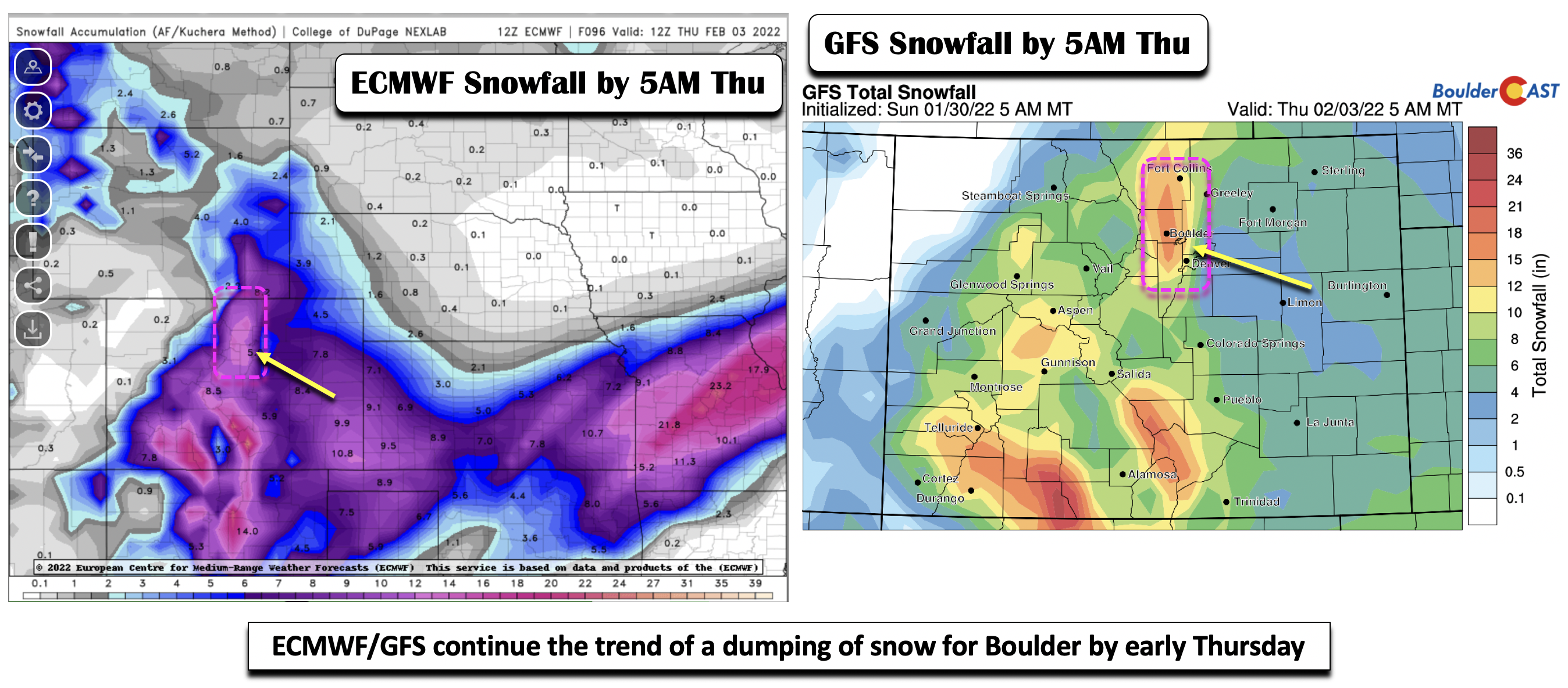
So what do the deterministic models predict right now? We should preface this by the fact that the GFS/ECMWF have been very consistent that the highest snowfall totals will take place in Boulder and nearby Foothills. Given the nature of the event as a long-duration upslope storm with little jet forcing, it is no surprise they are favoring Boulder. Nevertheless, the entire Front Range will see some snow — just how much is the question. The GFS and Euro models both predict 7 to 15″ in Boulder and lesser amounts (3-8″) in Denver by 5AM Thursday.
The High Country will not be spared either, with the southern and southwest part of the state likely seeing 1 to 2 feet of snow with deep moist flow penetrating into the southwest part of the state — Wolf Creek skiers should be bouncing off the wall right about now!
Looking into our GEFS snow probabilities, they point to a 60% chance of exceeding 8″ in Boulder. For Denver, amounts are less, consistent with the deterministic models above, with a good probability for 3-7″ (more in the northwestern suburbs such as Broomfield). The ensembles have been lower than the deterministic models, perhaps due to the fine-scale nature of the upslope in the region around Boulder. The current mean from the GEFS shows around 0.6″ of liquid equivalent, but with snow ratios potentially as high as 18:1, this could mean up to a foot of snow in Boulder.

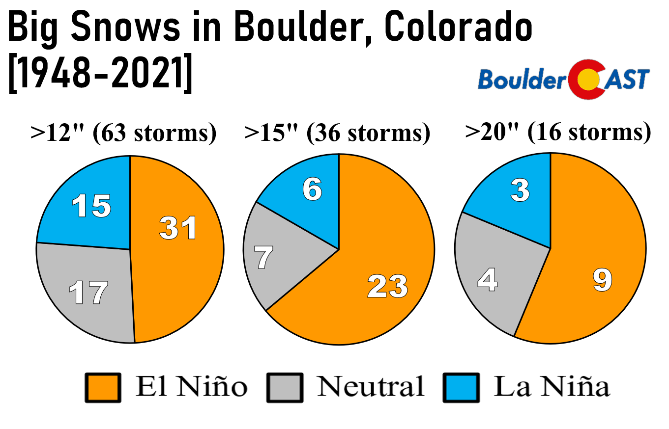
Pattern recognition also shows us that this storm is most likely to be one that could potentially produce close to a foot or snow in Boulder which is rare during La Niña, but just as we saw last March, it can happen regardless of what’s going on in the tropical Pacific Ocean.
To summarize:
- This is likely to be a more significant snowstorm for Boulder than Denver
- Widespread hazardous driving conditions are expected Tuesday night through Wednesday in and near the Foothills — limit travel if possible
- Tuesday is cold and cloudy to start, with lower 30s dropping into the 20s and teens by nightfall
- Light snow likely begins around rush hour Tuesday, increasing through the night
- Snow continues off and on Wednesday, especially in Boulder, tapering off late Wednesday night
- Bitter cold temperatures throughout the period with sub-zero readings possible by sunrise Thursday
Thoughts to consider:
- We will likely issue our official snowfall forecast map Monday evening
- The high-resolution suite of models, such as the NAM, HRRR and NAM-NEST, need to be considered and they are just starting to come in now
- Small changes in the storm track are likely, which will impact the duration/pattern of upslope
Some potential deterrents to a significant snowstorm:
- The very cold airmass will favor high snow ratios, but if it gets too cold we could see more needles and plates (less accumulation) than dendrites?
- Some models show a more east-southeasterly flow than northeasterly, which is not the most ideal upslope pattern. Upslope directionality will need to be closely monitored as it will greatly impact the snow potential with this largely upslope-driven event
- Very little jet forcing — likely no snow banding with primarily just light snowfall rates
Positives for a significant snowstorm for Boulder:
- Deep upslope for a long duration, roughly 24 to 30 hours
- Very cold air and higher than typical snow ratios
- Good lift located smack in the middle of the dendritic growth zone favoring efficient snowfall production
- Anomalous moisture aloft spreading into Colorado from the southwest
Preliminary snowfall totals:
- Boulder area: 6-11″
- Foothills: 7-13″
- Denver area: 3-7″, lowest east and higher west
Highs on Wednesday with the snow will only be in the upper teens, likely to occur early in the afternoon, as temperatures fall into the single digits by evening behind another surge of Arctic air.
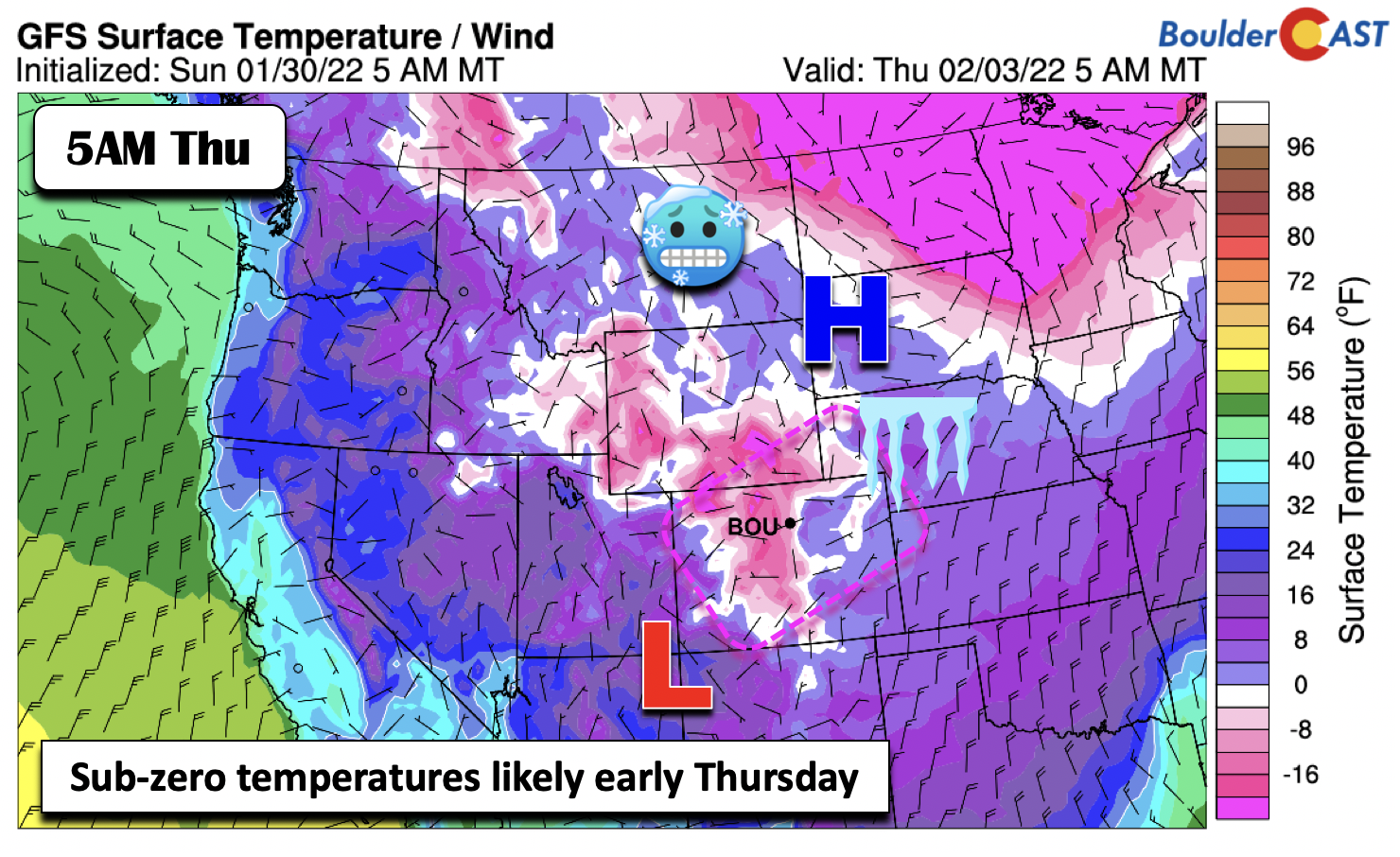
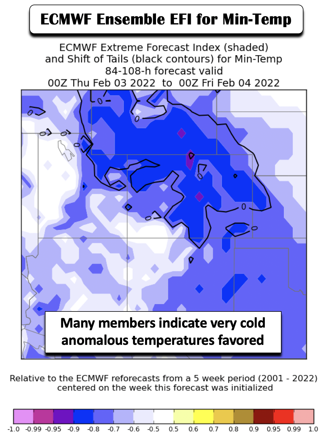
As the system pulls out Wednesday night, clear skies (maybe), light winds, and fresh snow cover should lead to sub-zero readings for the area, perhaps our coldest of the season. The figure below shows the ECMWF ensemble EFI for minimum temperatures Wednesday night. Values exceeding 0.8 more or less confirms the anomalous Arctic air in place for this period.
Turning quiet by week’s end
While Thursday will remain cold in the teens again, it will be sunny and quiet, albeit with likely several inches of fresh snow over the area. A weak ridge of high pressure will settle over the region into Friday, ushering in a boring end to the week as highs get back into the 30s to end the work week.
Stay up to date on the snow and be sure to check back for our official snow map and final expected amounts. Stay warm and think snow!
Stay up to date with Colorado weather and get notified of our latest forecasts and storm updates:
Forecast Specifics:
Monday: Morning wave clouds, giving way to partly sunny skies and highs in the lower to middle 50s on the Plains and lower 40s in the Foothills.
Tuesday: Colder with highs only in the lower 30s under increasing clouds. Light snow develops around rush-hour Tuesday and continues overnight.
Wednesday: Very cold with highs only in the upper teens on the Plains and single digits in the Foothills. Snow persists through the day, tapering off by late evening, with several inches of snow, perhaps upwards of a foot around Boulder. Highs in the teens on the Plains with single digits in the Foothills.
Thursday: Sunny and cold with highs in the teens on the Plains and single digits in the Foothills.
Friday: Sunny and warmer but still below average with highs in the lower 30s on the Plains and lower 20s in the Foothills.
Mountains: Quiet weather, albeit windy at times, will be found in the mountains on Monday. A significant winter storm will take aim on the High Country Tuesday through early Thursday, with all areas seeing some snowfall. The highest snow amounts will be over the south and southwest part of the state, with 1-3 feet possible in these areas. The best day to ski would be Thursday, Friday, and Saturday with fresh powder at Wolf Creek! Quiet weather returns by week’s end.

Help support our team of Front Range weather bloggers by joining BoulderCAST Premium. We talk Boulder and Denver weather every single day. Sign up now to get access to our daily forecast discussions each morning, complete six-day skiing and hiking forecasts powered by machine learning, first-class access to all our Colorado-centric high-resolution weather graphics, bonus storm updates and much more! Or not, we just appreciate your readership!
Spread the word, share the BoulderCAST forecast!


You must be logged in to post a comment.