
After one of the snowiest mid-winter stretches in Boulder’s history, it appears that things will quiet down somewhat for the week ahead. Temperatures will be fairly mild through the week. However, there will be several disturbances to watch which could produce snow across the Front Range — one Wednesday night with another to follow late Friday. Read on for our complete outlook for the week ahead.
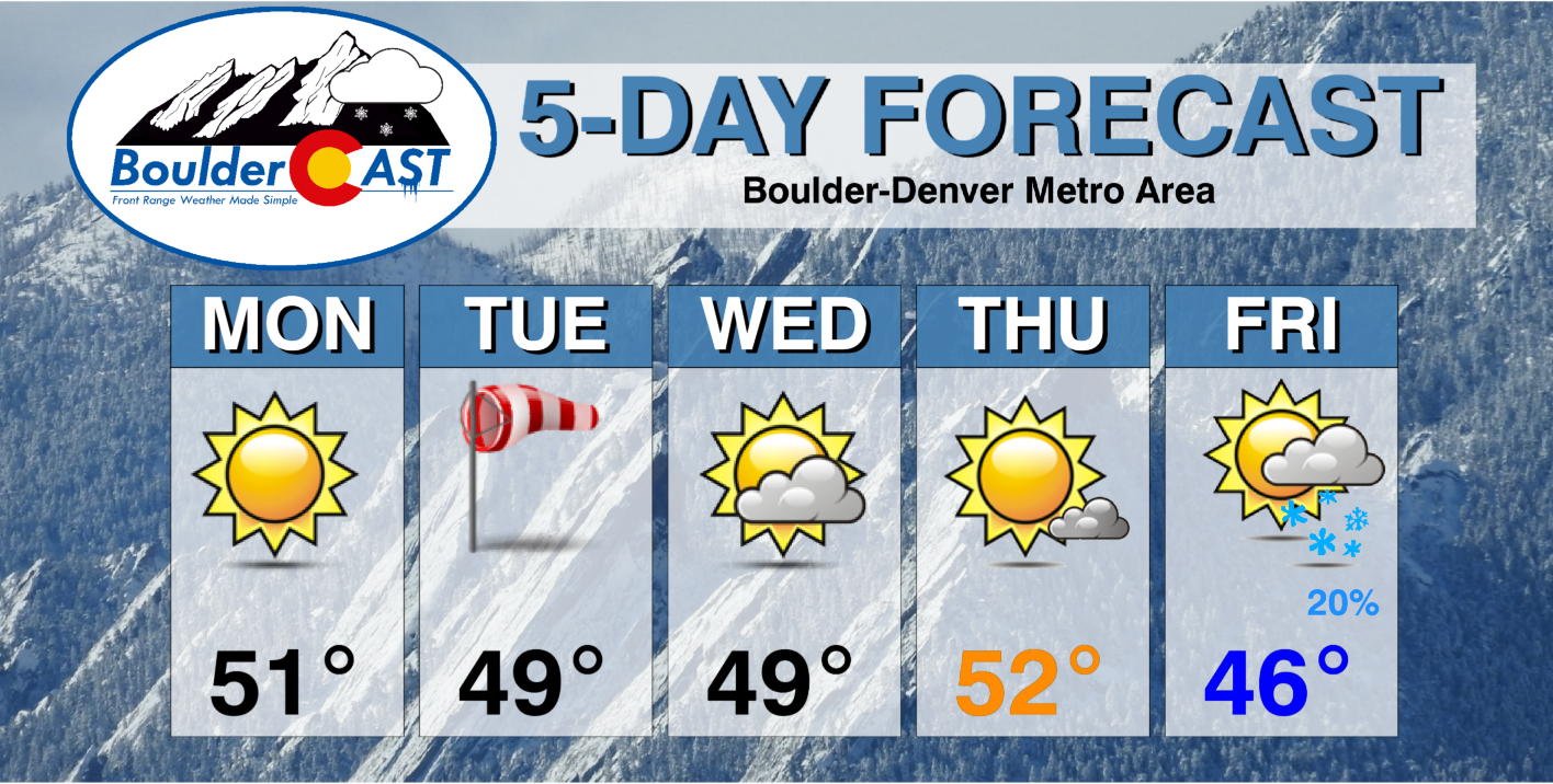
This week’s highlights include:
- Sunny and mild Monday and Tuesday with highs near 50 degrees
- A weak system will clip the area Wednesday night offering a slight chance of snow to northeast Colorado — this shouldn’t amount to much
- Thursday will be pleasant with temperatures in the lower 50’s
- Models diverge on how strong a late-week storm will be as it dips across Colorado
- Most models do produce at least light snow for us Friday evening and night, but amounts for now are up in the air
DISCLAIMER: This weekly outlook forecast is created Monday morning and covers the entire upcoming week. Accuracy will decrease as the week progresses as this post is NOT updated. To receive daily updated forecasts from our team, among many other perks, subscribe to BoulderCAST Premium.

Is the onslaught of snowfall starting to slow down? Perhaps.
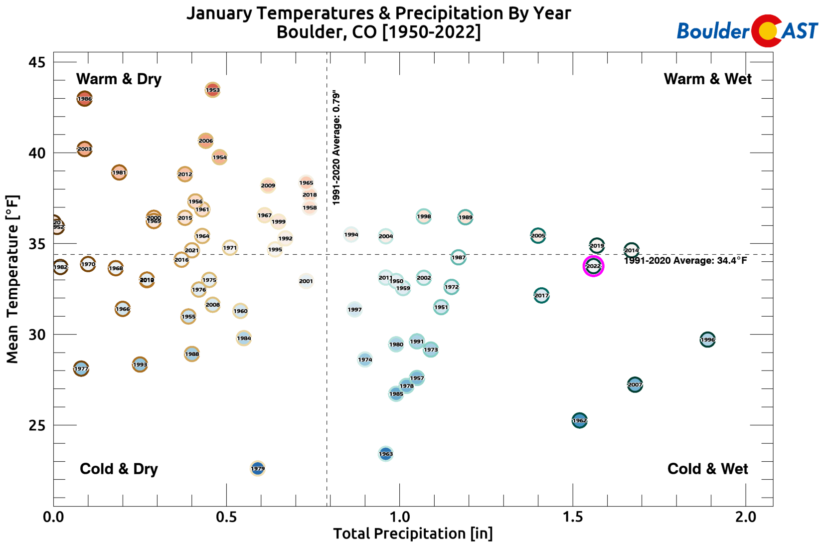
Boulder has seen more than three feet of snow fall since New Year’s Eve, the snowiest this stretch has ever been for the city in what is typically the driest time of the year. The onslaught of frequent snow events looks to take a break for the week ahead, but that’s not a guarantee as you will soon see…
Fun fact: This year has been the snowiest New Year's Eve to Groundhog Day period in Boulder –37.6". Take that 2014! #COwx
2022: 37.6"
2014: 31.0"
1996: 30.2"
1962: 30.1"
1987: 25.1"— BoulderCAST Weather (@BoulderCAST) February 3, 2022
January 2022 ended as Boulder’s fifth snowiest since 1950. It was also our first month that concluded colder than normal (just slightly) since May of 2021. More climatology graphics like the one below can be found in our recent January monthly recap post.
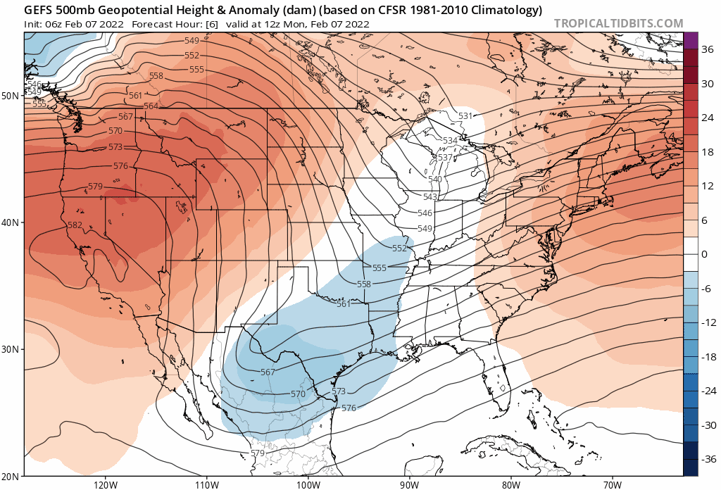
The week ahead will largely feature a stagnant dipole pattern across the continental United States with a deep trough intensifying across the East while a strong ridge remains parked over the Pacific Northwest and California. The general characteristics of this pattern really don’t shift much over the next seven days — so neither will our weather.
GFS ensemble mean 500mb height anomaly forecast animation through the week into the weekend.
Colorado will be stuck between these two features all week long under moderate northwest flow aloft. The western part of our state will be influenced more so by the ridge, while the Front Range will see a mix of both at times. Generally our weather will be quiet and somewhat mild through the period, but there are a few weak and fast-moving waves embedded in that northwest flow that we need to keep tabs on. Let’s take a look.
Weak wave #1
After a beautiful day on Monday with highs in the lower 50’s, the first weak disturbance will drop southward across the Great Plains on Tuesday. This one just barely brushes the Denver area and thus it will only have the most minor of impacts for us.

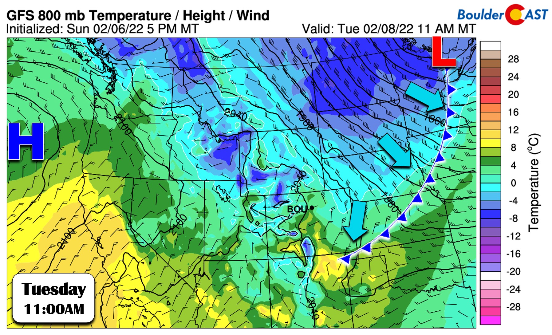
The associated cold front with this system will reach the Front Range during the early morning hours on Tuesday before sunrise. Low-level winds remain northerly or northwesterly behind this front and there is extremely limited moisture. With no upslope and no fuel, this will be a dry frontal passage, and a weak one at that. Temperatures on Tuesday fall back only a few degrees into the upper 40’s, but watch for breezy conditions during the afternoon hours.
Weak wave #2
Most of the day Wednesday we will be under the influence of the distant but potent ridge over the Pacific Northwest. However, by evening the next shortwave disturbance will be knocking on the door. Once again, the parent storm system is way off to the east in the Great Lakes, with just the faintest of a trailing trough axis stretching westward into Colorado. You can already tell from how subtle and distant this feature is that it won’t be a major player for us either.
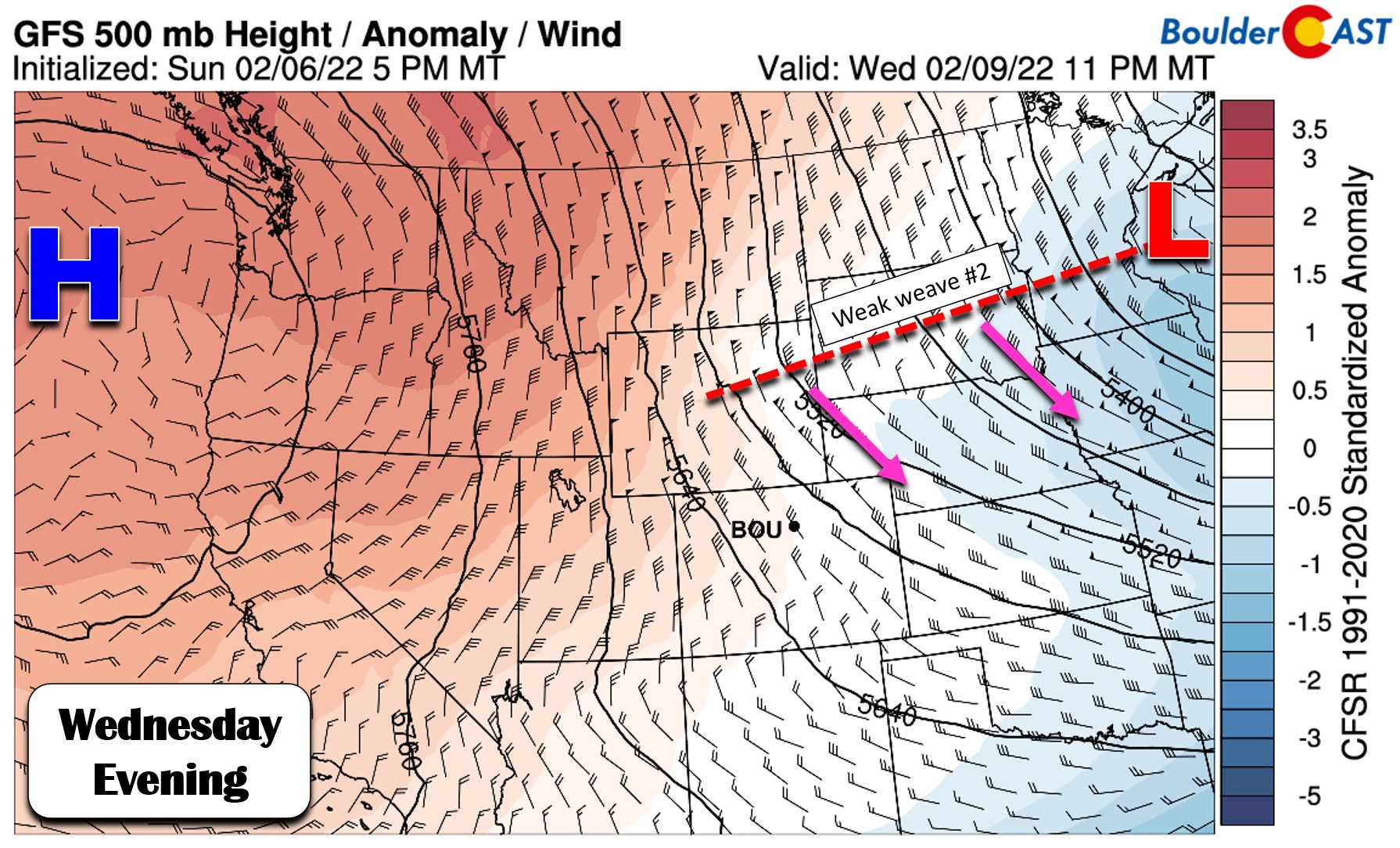
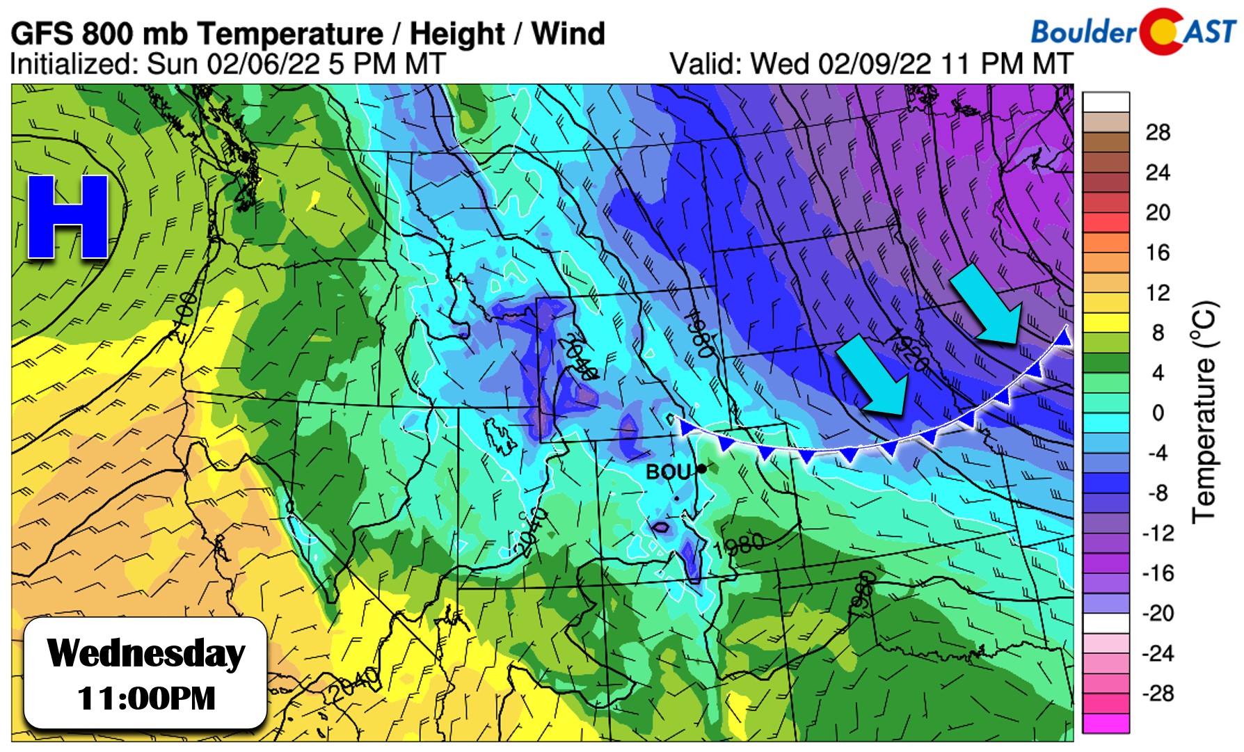
Similarly, there will be another cold front tracking across the area with this wave. It looks to arrive during the overnight period Wednesday night. This front has a tad more moisture to work with, but still not much. There will be a few snow showers developing across northeast Colorado Wednesday night. These are most likely to occur out across the eastern Plains, but these do have a low chance to clip our area as well (especially if winds can turn northeasterly).
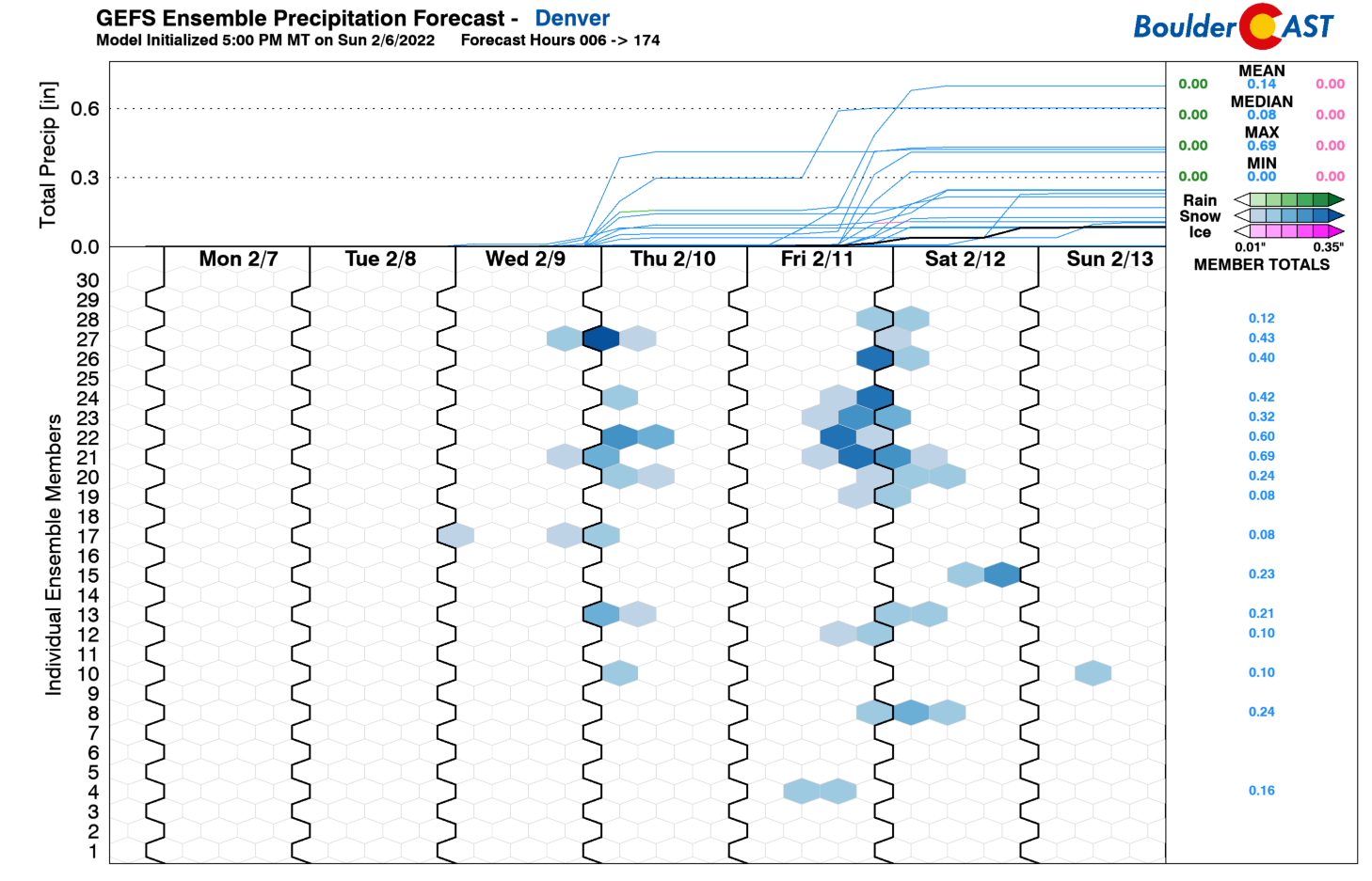
We should mention that the operational GFS model really wants to develop a burst of moderate snow as the cold front passes late Wednesday night — spitting out something like 1 to 4″ of snow across the Denver Metro area with higher amounts over the Palmer Divide.
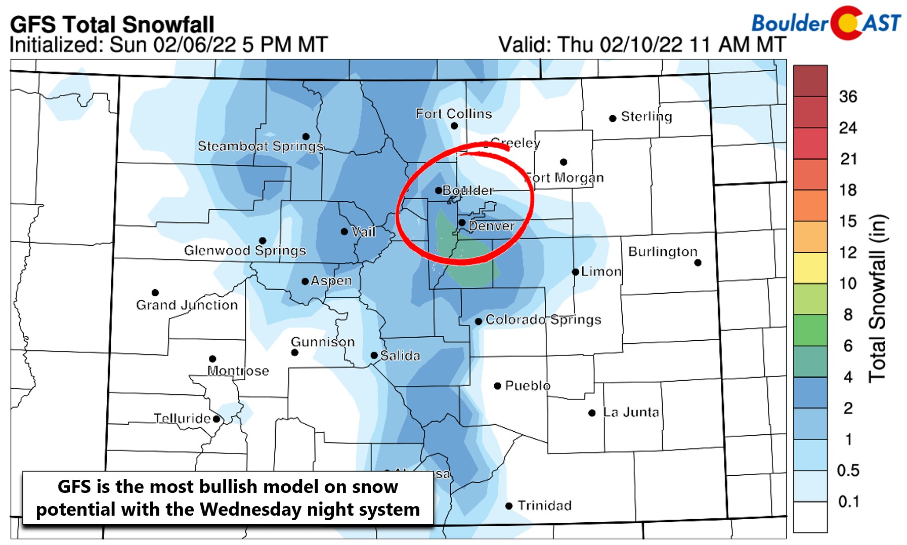
However, the GFS is a big outlier right now! It’s much more generous with snow for the area than all other models, and even its own ensemble suite (shown below). Thus, our forecast will be tailored towards a drier solution with a spotty dusting or less of snow expected by Thursday morning. Most of us should see next to nothing at all.
Thursday morning could be on the chilly side as the cooler airmass behind the front will be in place. However, its stay will be very brief with downslope taking over by afternoon causing temperatures to warm into the lower 50’s.
Weak wave #3
We’ll polish off the work week on Friday with yet another weak disturbance dropping southward across Colorado. There is some model variation right now, but this system has perhaps the best chance to get a little precipitation going across eastern Colorado. The Euro model (below left) shows something very similar for this system to what transpires on Wednesday — basically just a slight wind shift, a tiny cold front and spotty snow showers for the area. The GFS model develops a more substantial trough across the Rockies which eventually cuts off into New Mexico.

As it stands now the Euro moves the storm through about 12 hours faster leading to highs only in the 30’s on Friday with a chance of light snow in the afternoon and evening. The GFS is slower and stronger with this storm allowing temperatures to rise close to 50 degrees on Friday, but with snow developing during the evening and overnight period for the Front Range. At the moment it appears that some snow will materialize with this storm, but probably not too much (unless the bullish GFS verifies). For now, we’ll include a dabble of snow Friday afternoon into Friday night with temperatures in the 40’s and falling. We’ll continue to monitor this late-week storm with hopeful eyes, so do check back for updates through the week.
Stay up to date with Colorado weather and get notified of our latest forecasts and storm updates:
Forecast Specifics:
Monday: Sunny and quiet with highs in the lower 50’s on the Plains and in the upper 30’s in the Foothills.
Tuesday: Mild and breezy with sunny skies. Winds could gust up to 30MPH during the day. Highs in the upper 40’s on the Plains with upper 30’s in the Foothills.
Wednesday: Increasing clouds with a very slight chance of snow overnight into Thursday. Little to no accumulation is expected. Temperatures will be in the upper 40’s on the Plains with upper 30’s in the Foothills.
Thursday: Possibly a few morning clouds or lingering flurries, then mostly sunny. Highs in the lower 50’s across the Plains with upper 30’s in the Foothills.
Friday: Sunshine early, then increasing clouds through the day with a slight chance of snow developing by afternoon or evening. Light accumulations possible through the overnight. Timing and potential snow amounts remain uncertain. Temperatures cooler in the 40’s across the Plains with 30’s in the Foothills.
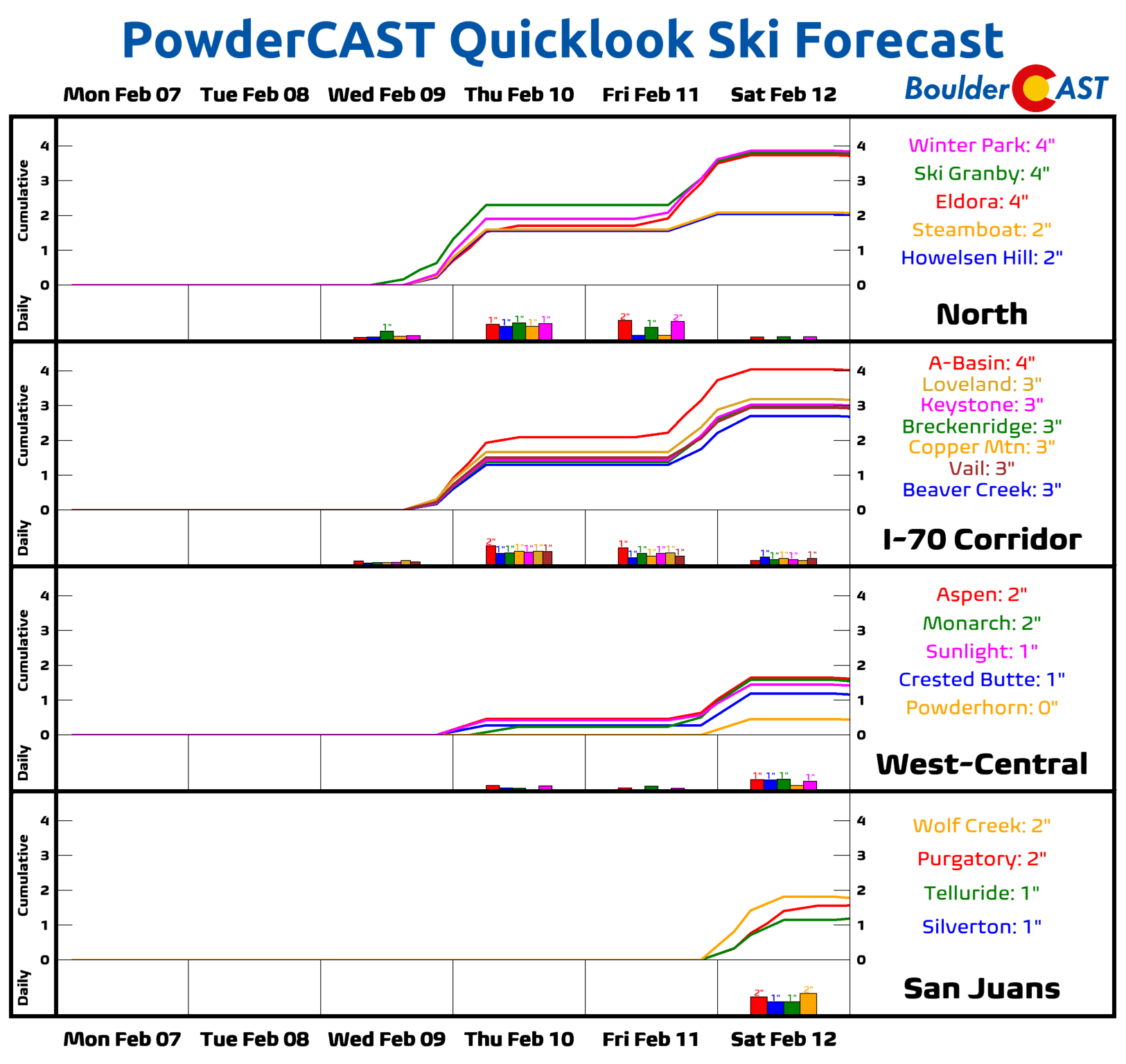
Mountains: The High Country will see fairly quiet weather through the week with the main concern being gusty northwest winds at times with seasonal to mild temperatures. Most of the week will be dry, but the Wednesday night and Friday night systems could bring light snow accumulations to portions of the state, particularly if the GFS model solutions verify (it is currently a snowy outlier). Don’t expect any resorts to offer much in the way of powder this week, though.
Help support our team of Front Range weather bloggers by joining BoulderCAST Premium. We talk Boulder and Denver weather every single day. Sign up now to get access to our daily forecast discussions each morning, complete six-day skiing and hiking forecasts powered by machine learning, first-class access to all our Colorado-centric high-resolution weather graphics, bonus storm updates and much more! Or not, we just appreciate your readership!
Spread the word, share the BoulderCAST forecast!


You must be logged in to post a comment.