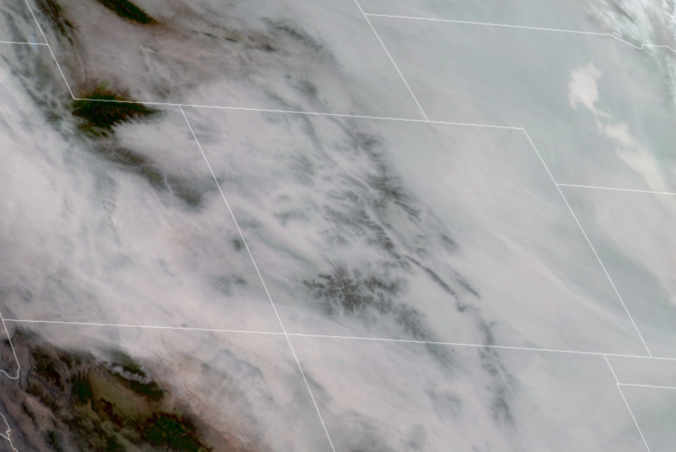
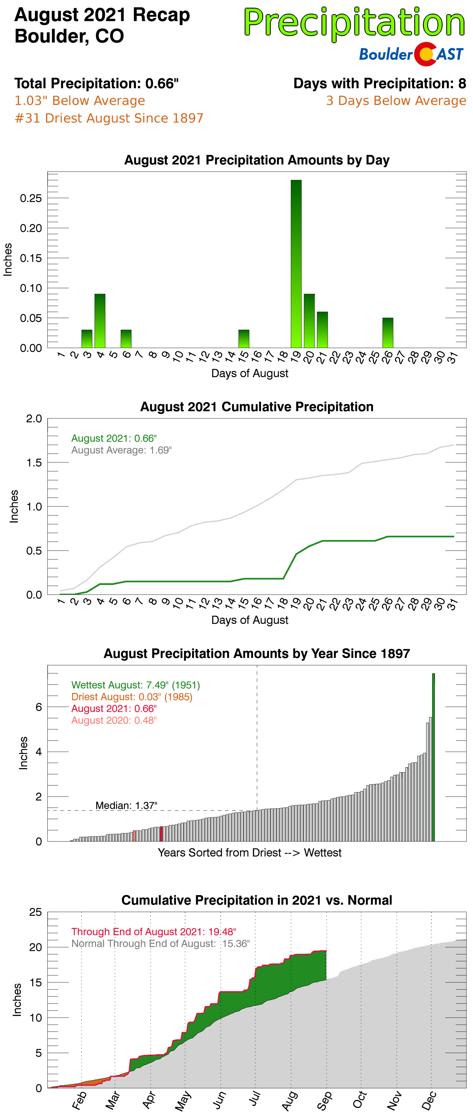
August 2021 across the Front Range was defined by its poor air quality and tenacious smoky skies which were mostly caused by out-of-state wildfires. Other weather highlights during the month included a rotating thunderstorm which prompted tornado sirens, lots of red smoky sunsets, a sprinkle of summertime snow in the Mountains, and the landfall of Category 4 Hurricane Ida sixteen years to the day after Hurricane Katrina. Here’s a quick and colorful recap of our weather during August and how it relates to climatology.
Help support our team of Front Range weather bloggers by joining BoulderCAST Premium. We talk Boulder and Denver weather every single day. Sign up now to get access to our daily forecast discussions each morning, complete six-day skiing and hiking forecasts powered by machine learning, first-class access to all our Colorado-centric high-resolution weather graphics, bonus storm updates and much more! Or not, we just appreciate your readership!
Top Weather Highlights of August 2021:
A LITERAL WALL OF SMOKE! The most memorable aspect of Colorado weather during the month occurred on August 7th when a storm system moving across the northern Rockies swept a massive wall of smoke from wildfires in the Pacific Northwest across our entire state.
Brace for impact…#COWx #Smokeggedon pic.twitter.com/g5aBRU0Y7t
— BoulderCAST Weather (@BoulderCAST) August 7, 2021
This smoke front brought the worst air quality of 2021 to our area. At the peak, we saw PM2.5 Air Quality Indices climb to around 180 in the Boulder/Denver area during the afternoon hours.
2:30PM Smoke Update: PM2.5 Air Quality Indices have been very slowly climbing for hours! #COwx #Smoke
😢Boulder: 180
😢Erie: 180
😢Rocky Mtn NP: 175
😢Nederland: 175
😢Louisville: 175
😢Broomfield 175
😢Longmont: 175
😢Denver: 170
😢Aurora: 170
😢Golden: 165
😢Ft Collins: 165 pic.twitter.com/UIfX2DjVPt— BoulderCAST Weather (@BoulderCAST) August 7, 2021
The smoke made viewing the Flatirons a challenge, even from Boulder!
Another beautiful Saturday morning in #Boulder… WAIT! 😢#Smoke #COwx pic.twitter.com/v319AzdiFW
— BoulderCAST Weather (@BoulderCAST) August 7, 2021
It took nearly a week for the smoke to clear out across the region. This period was the smokiest and unhealthiest air we’ve endured all summer long. That’s saying a lot considering we’ve shattered the existing record for days with Air Quality Alerts in effect…54 days and counting as of September 1st!
CONTINUED SMOKE: With so, so many large wildfires burning across California, the Pacific Northwest, southern British Columbia and the northern Rockies, smoke was with us nearly every single day in August, though there were a few “bluer” days towards the tail-end of the month.
Many huge fires are burning in CA, OR, WA, MT & BC right now. Thick smoke has once again been pooling under a center of high pressure across the Pacific Northwest the last several days…. #COwx #Smoke pic.twitter.com/VsCVv1RyHd
— BoulderCAST Weather (@BoulderCAST) August 15, 2021
As we are all well aware at this point, smoke makes for great sunsets. This was the sunset on August 16th:
Another smoky sunset over #Boulder this evening, with even some bonus crepuscular rays #COwx #Smoke pic.twitter.com/8bHyiZtJ2q
— BoulderCAST Weather (@BoulderCAST) August 17, 2021
TORNADO SIRENS? While August is not typically know to be peak tornado season in Colorado (that’s May and early June!), a unique setup on August 19th spawned several strong to severe thunderstorms across northeast Colorado.
⚠️Clearing is underway across the area and this afternoon's severe outbreak remains on track! ⚠️
The window for hail & strong winds in the immediate #Boulder/Denver area is approx. 1PM-6PM. Storms shift NE through the evening with increased tornado risk along I-76 #COwx #Hail pic.twitter.com/eQmcmiFD57
— BoulderCAST Weather (@BoulderCAST) August 19, 2021
One particularly fierce thunderstorm formed in Arvada in the middle of the afternoon and moved northeast through Broomfield and Westminster. This storm indicated tight rotation on radar which prompted a Tornado Warning from the National Weather Service. We took this photo as the rotating storm moved over Broomfield.
The tornado-warned mothership cloud over Broomfield #COwx pic.twitter.com/JaXXK6cym8
— BoulderCAST Weather (@BoulderCAST) August 19, 2021
Our friend Ryan Harp’s timelapse of the same cloud was even more stunning….
Brief time lapse of the tornado-warned storm as it zipped through Broomfield and Westminster. #cowx pic.twitter.com/pwLc9TjEGr
— Ryan Harp (@RyanDHarp) August 19, 2021
This impressive thunderhead never did spawn a tornado or even a funnel cloud in the Denver Metro area, but it did drop a swath of large hail up to half dollar size (1.25″). Below are the severe weather reports from that day. Note that a least one weak tornado did eventually form near the Nebraska border later that day.
WINTER IS COMING HERE!? Within hours of the severe weather, snow was falling in the Mountains to the west of the Denver area. On the morning of August 20th, it looked like winter when the sun rose in Rocky Mountain National Park! Up to 3 inches of frozen precipitation fell overnight above 10,000 feet elevation! While Colorado’s highest peaks are no stranger to snow in the summer, snow levels rarely drop down this low in August!
DROUGHT MAKES A COMEBACK IN NORTHEAST COLORADO: After several months of largely below normal precipitation this summer (thanks crappy monsoon!), drought has reared its ugly head again in portions of northeast Colorado. As of August 31st, 51% of Colorado was under a drought classification from the US Drought Monitor, up slightly from 49% three months ago. More importantly though, we have seen the most severe drought improve somewhat across the Western Slope this summer.
BREATHE IT ALL IN! Towards the end of the month, we were treated to a few smoke-free days across the Front Range. The bluebird skies confused many people, including us! It was easy to forget what our sky is supposed to look like this summer, one which has been plagued by persistent smoke.
Who else forgot the sky should actually be this blue?? 😲 #COwx #Boulder #Smoke pic.twitter.com/GDqRSSkCHs
— BoulderCAST Weather (@BoulderCAST) August 24, 2021
16 YEARS, TWO CAT FOURS: Hurricane made landfall into Louisiana on August 30th, 16 years to the day after Hurricane Katrina made a strike in nearly the same location.
Hurricane Ida has just developed a perfectly symmetric eye this morning in the last hour to two. The storm currently has sustained winds of 150MPH, and is on the cusp of going Cat 5 moments before landfall into Louisiana #LAwx #Ida #NotCOwx pic.twitter.com/HQNezi8EC2
— BoulderCAST Weather (@BoulderCAST) August 29, 2021
Ida will go down as one of the most rapidly intensifying tropical cyclones in the Atlantic Basin record. It will also be remembered for how long it maintained Category 4 status after making landfall. In the swampy Bayou area of the Mississippi River Delta, Ida continued to feed off the wetlands area well away from the open ocean.
We have landfall… pic.twitter.com/cBCOV9QSOY
— BoulderCAST Weather (@BoulderCAST) August 29, 2021
Two days later Ida was a Tropical Depression but caused massive flooding in the Mid-Atlantic and Northeast. The United States death toll rose to at least 25, most of which occurred in the northeast, not near the landfall site. To everyone affected by this storm, our thoughts and hearts are with you!
August 2021 Recap Graphics:
Where does August 2021 fit into the last 12 months?
Spread the word, share Colorado weather:
We discuss Boulder and Denver weather every single day on BoulderCAST Premium. Sign up today to get access to our daily forecast discussions every morning, complete six-day skiing and hiking forecasts powered by machine learning, access to all our Front Range specific weather models, additional storm updates and much more!


You must be logged in to post a comment.