
As February limps toward the finish line, Colorado’s “winter” continues to behave like anything but. Last week the Mountains cashed in on a burst of Pacific moisture while the Denver Metro area stayed stubbornly snow‑starved. The week ahead brings more of that same split personality—warmth, wind, fire danger, and another round of Mountain snow. We break down the lopsided snow totals from last week, the updated but still troubling snowpack numbers, and discuss why this week will be so darn warm and windy again in the Front Range.
This week’s highlights include:
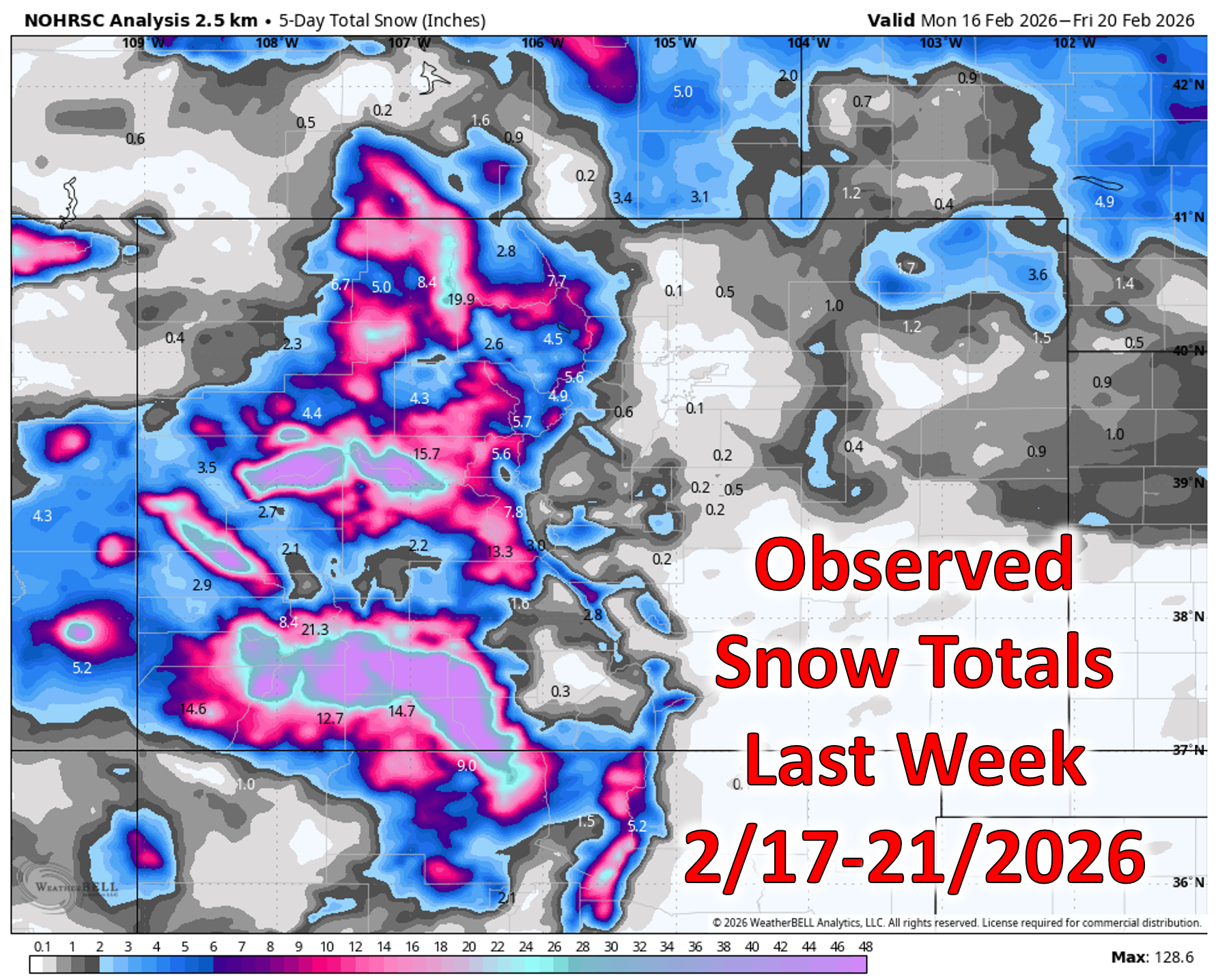
- ❄️ Good Mountain Snow Last Week: Last week’s Pacific moisture plume dumped much-needed snow in the High Country, with Wolf Creek hitting 70 inches in five days. Denver & Boulder saw only a trace, keeping this winter’s snow totals historically bleak.
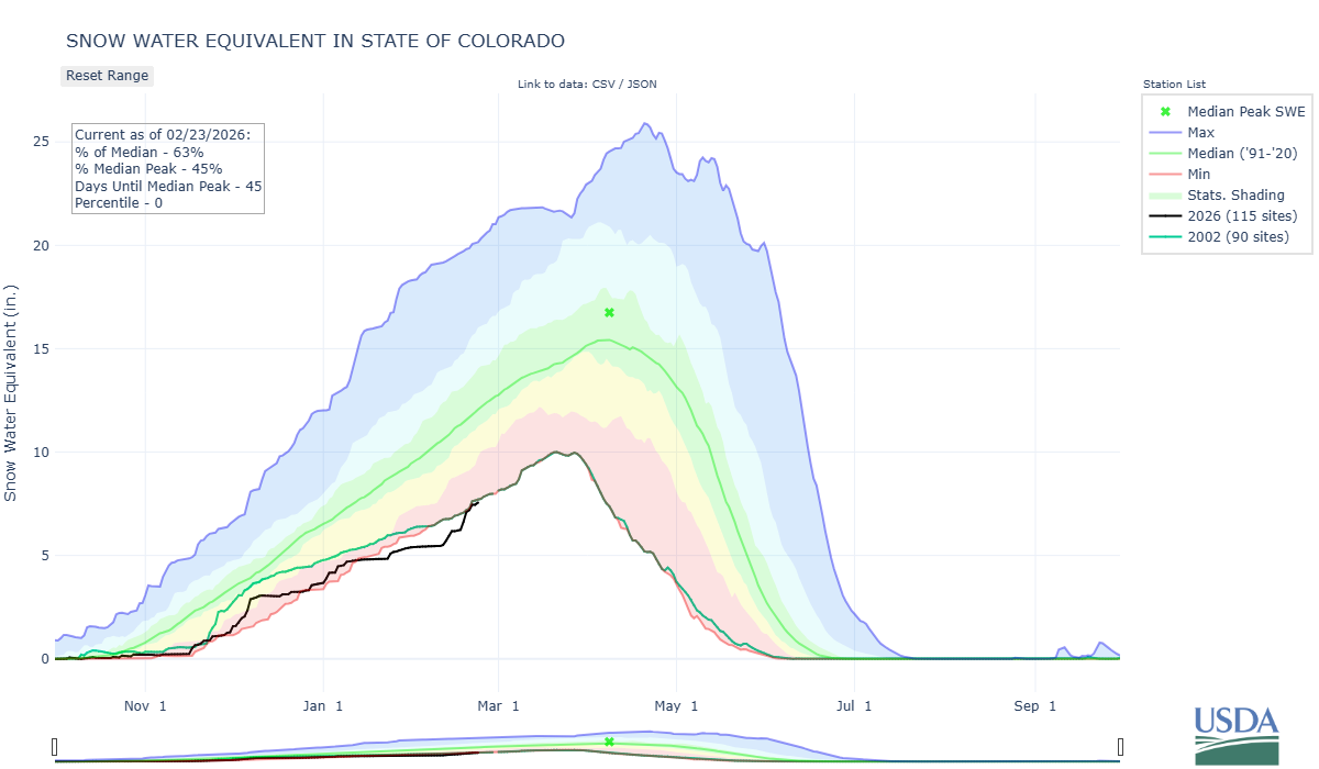
- 📉 Snowpack West-wide Still Dire: A brief bump puts Colorado at 63% of normal, basically tied with 2002 for worst snowpack-to-date.
- 🌤️ Warm Start to the Week: Monday surges into the mid‑60s under thin cirrus—with quiet conditions and light winds.
- 💨 Wind Machine Ramps Up: Tuesday–Wednesday bring strong winds (up to 90 MPH gusts in the Mountains). More widespread winds Wednesday for everyone with gusts of 40+ MPH. Red Flag Warnings in effect for Tuesday.
- 🌨️ Mountain Snow Midweek: Northern ranges favored with 5–16 inches Tuesday afternoon into Wednesday evening. Mountain travel will be dicey due to falling snow and high winds.
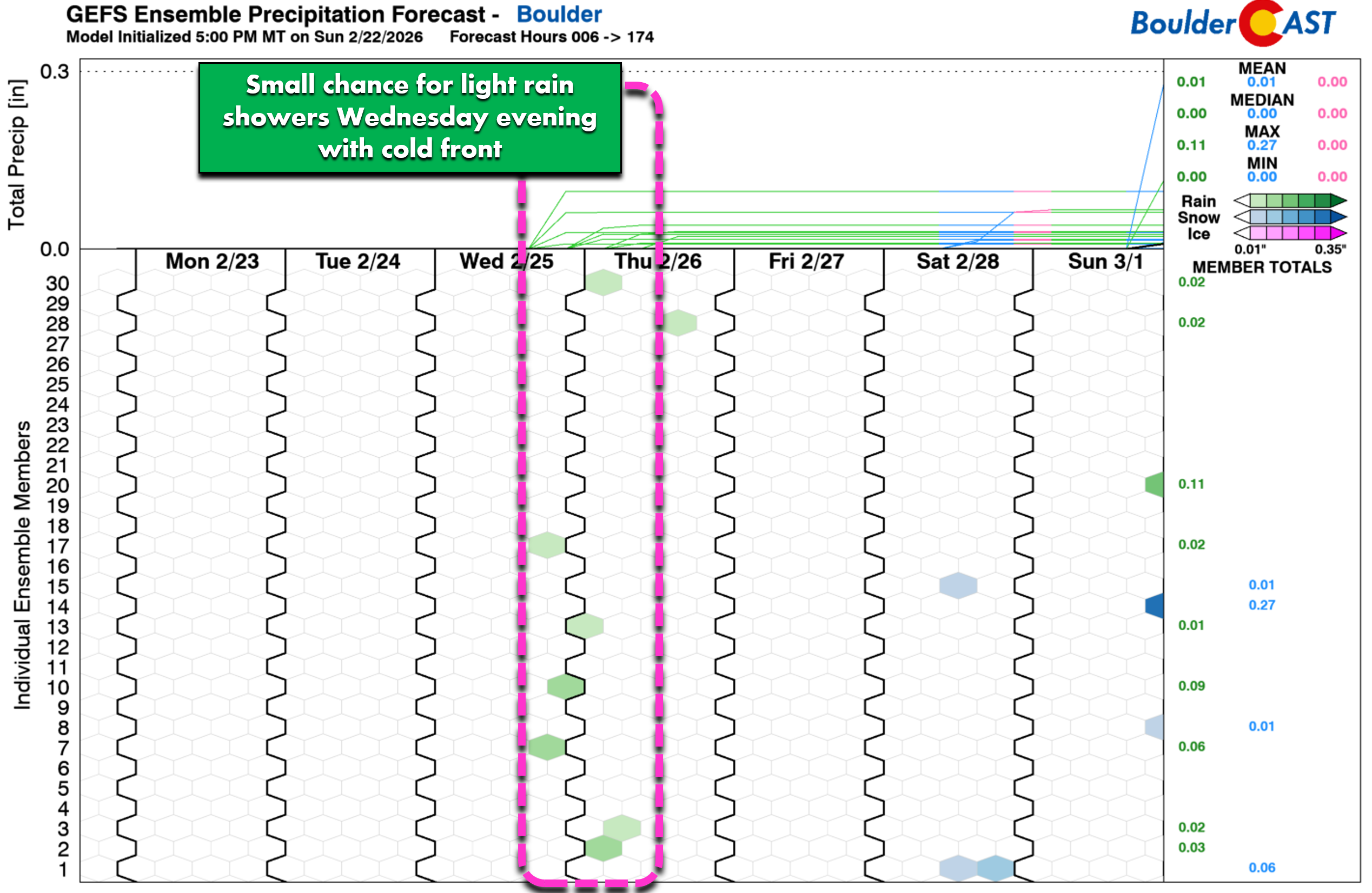
- ☂️ Slight Chance of Rain Late Wednesday: As a cold front passes, a few meager rain showers may spawn Wednesday evening in the Metro area.
- 🔥 Late‑Week Stays Warm & Breezy: Highs in the 60s with renewed fire concerns—concluding another week that feels nothing like February. Red Flag Warnings possible Thursday and Friday.
DISCLAIMER: This weekly outlook forecast is created Monday morning and covers the entire upcoming week. Accuracy will decrease as the week progresses as this post is NOT updated. To receive daily updated forecasts from our team, among many other perks, subscribe to BoulderCAST Premium.

Go Premium, get all the perks.
Daily Forecast Updates
Get our daily forecast discussion every morning delivered to your inbox.
All Our Model Data
Access to all our Colorado-centric high-resolution weather model graphics. Seriously — every one!
Ski & Hiking Forecasts
6-day forecasts for all the Colorado ski resorts, plus more than 120 hiking trails, including every 14er.
Smoke Forecasts
Wildfire smoke concentration predictions up to 72 hours into the future.
Exclusive Content
Weekend outlooks every Thursday, bonus storm updates, historical data and much more!
No Advertisements
Enjoy ad-free viewing on the entire site.
Mountain snowfall boost last week
Last week’s plume of Pacific moisture slammed into Colorado with impressive force—at least for the Mountains. The High Country cashed in statewide, but the San Juans stole the show with widespread 2 to 4 feet of accumulation. The heavyweight champion was, unsurprisingly, Wolf Creek, which tallied a jaw‑dropping 70 inches over five days. That’s nearly six feet of snow!
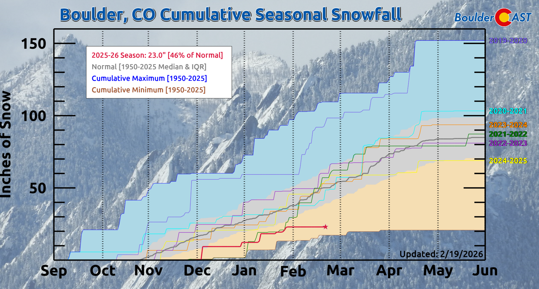
All that Mountain snow did give statewide snowpack a noticeable bump on the timeline. We’re now sitting at 63% of normal, essentially tied with 2002 for the worst snowpack-to-date on record. A sobering comparison, given what followed that year.
Meanwhile, east of the Divide we got a whole lot of nothing. Denver and Boulder each managed only a trace of snow—a familiar chorus in this lopsided winter.
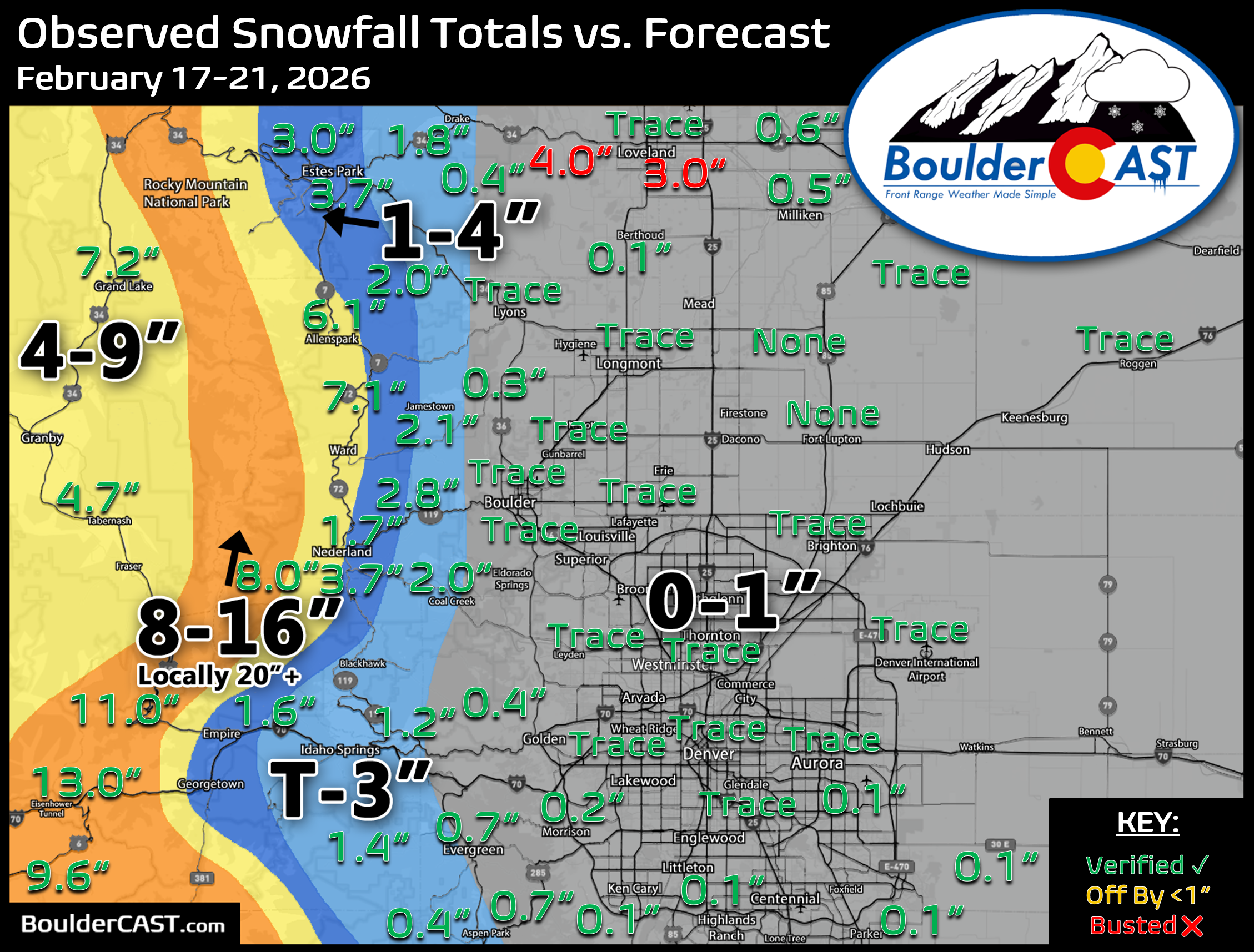
Boulder (and Denver) have yet to see any measurable snow in February and that likely won’t change as we close out the month this week. This will be the first time Boulder has failed to record measurable snow in February since 1992.
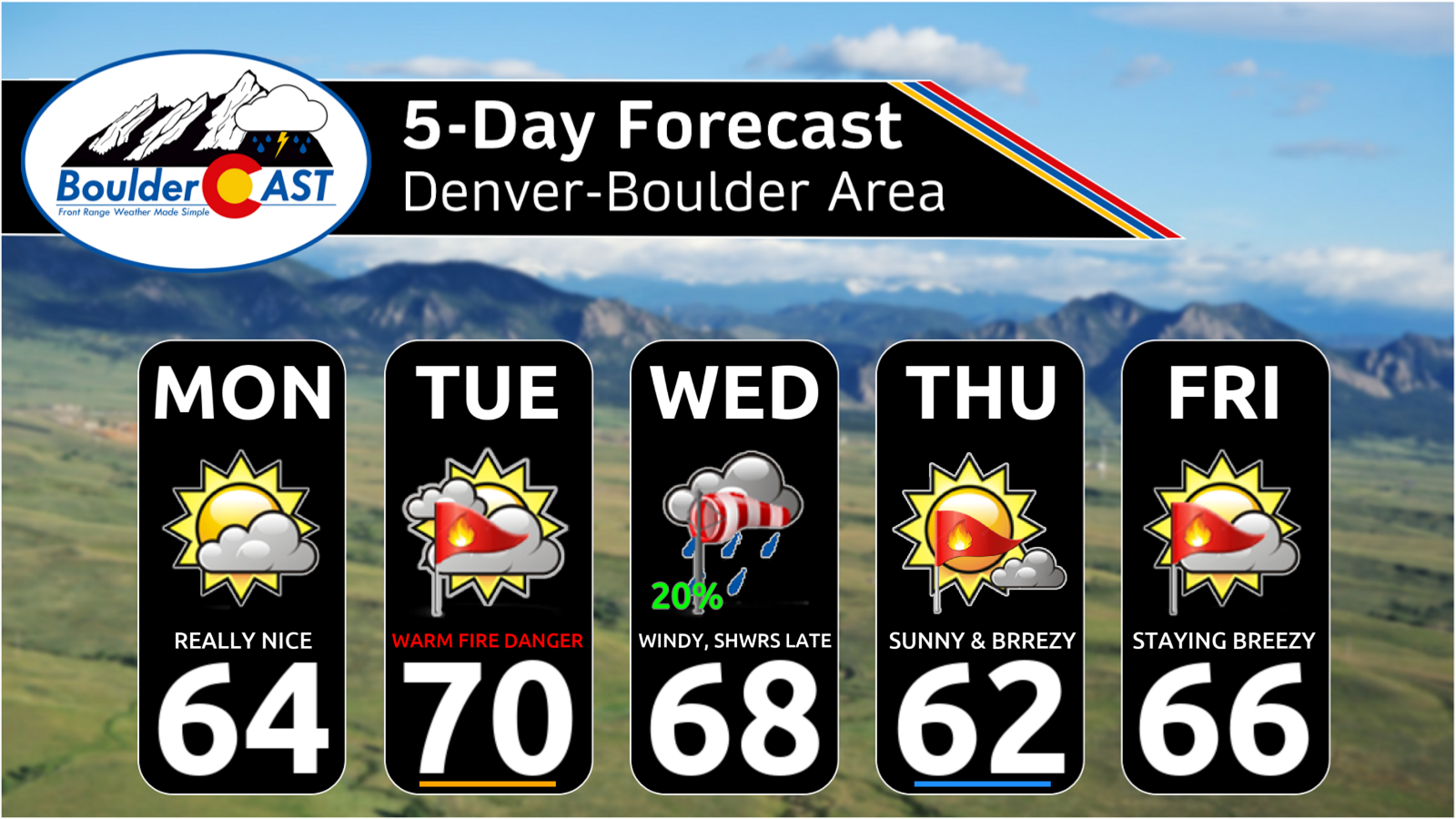
Monday: Quiet, Warm, and Not at All February
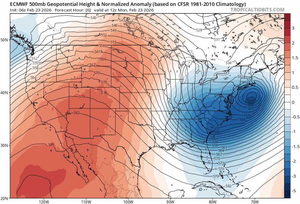
This week will feature a continuation of the dipole weather pattern that has plagued our area all winter long, with warm and windy weather across the West and more cold and snow for the East…
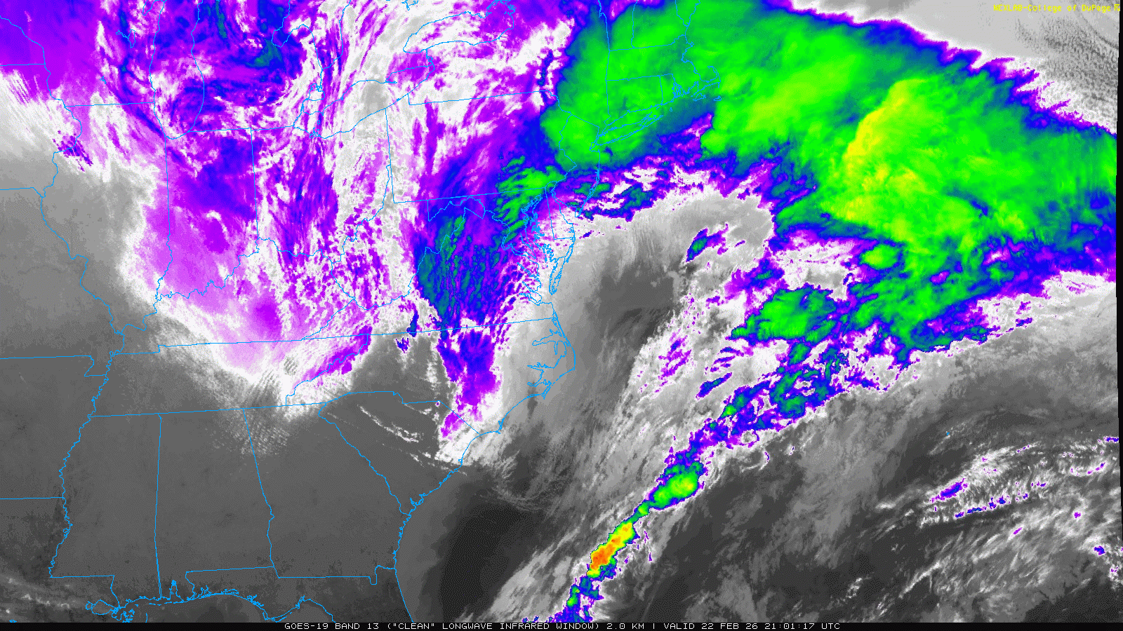
While we bask under a ridge, the Northeast is getting hammered by a full‑blown nor’easter this Monday morning. Blizzard conditions stretch from DC to Boston with 1–2 feet of snow and 40+ MPH gusts. GOES-East imagery shows a classic wrapped-up cyclone offshore—almost hurricane‑like in its symmetry. Many spots hit by this single storm will finish the day with more snow than Denver has received all winter.
Back home, the Southwest ridge remains locked in place, centered near Baja. It briefly bulges north into Canada before flattening midweek as several shortwaves skim the northern tier. That flattening will tighten the pressure gradient over Colorado—our cue for wind.
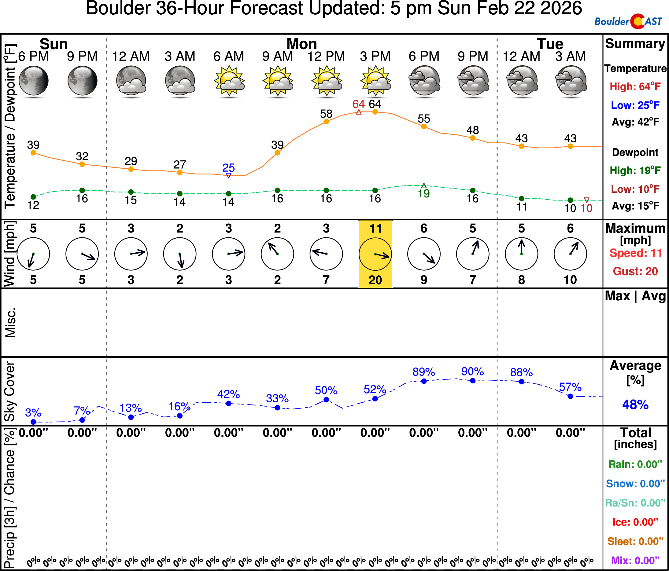
We’re starting out cold on Monday morning in the 20s, but a significant jump in temperatures will occur through the day, with highs soaring into the middle 60s. For reference, the average high for February 23rd in Boulder is 49°F. Quiet conditions and light winds are expected with our skies populated by a thin deck of cirrus and occasional wave clouds.
Tuesday–Wednesday: Wind & Mountain Snow
By Tuesday, the ridge will start to get beaten down by a passing shortwave disturbance riding along the Canadian border, with the pressure gradients slowly ramping up in our neck of the woods.
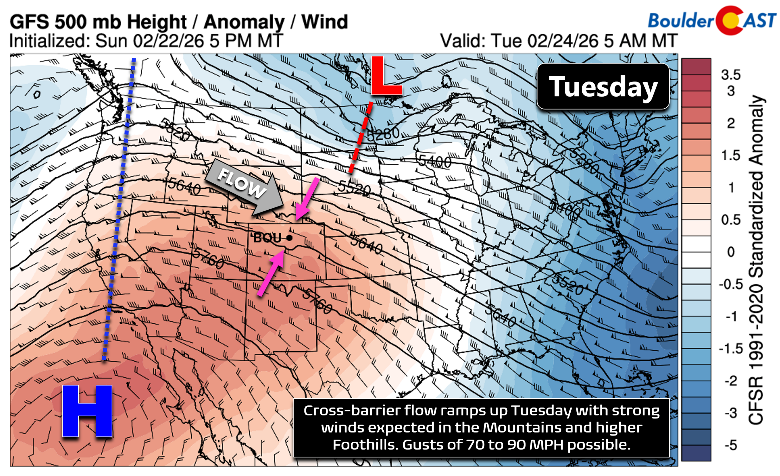
At the same time, a strong 155 MPH jet will come ashore and set up shop across the central Rockies, wobbling around throughout Colorado much of the week ahead leading to cross-barrier flow increasing across Colorado from the west-northwest.
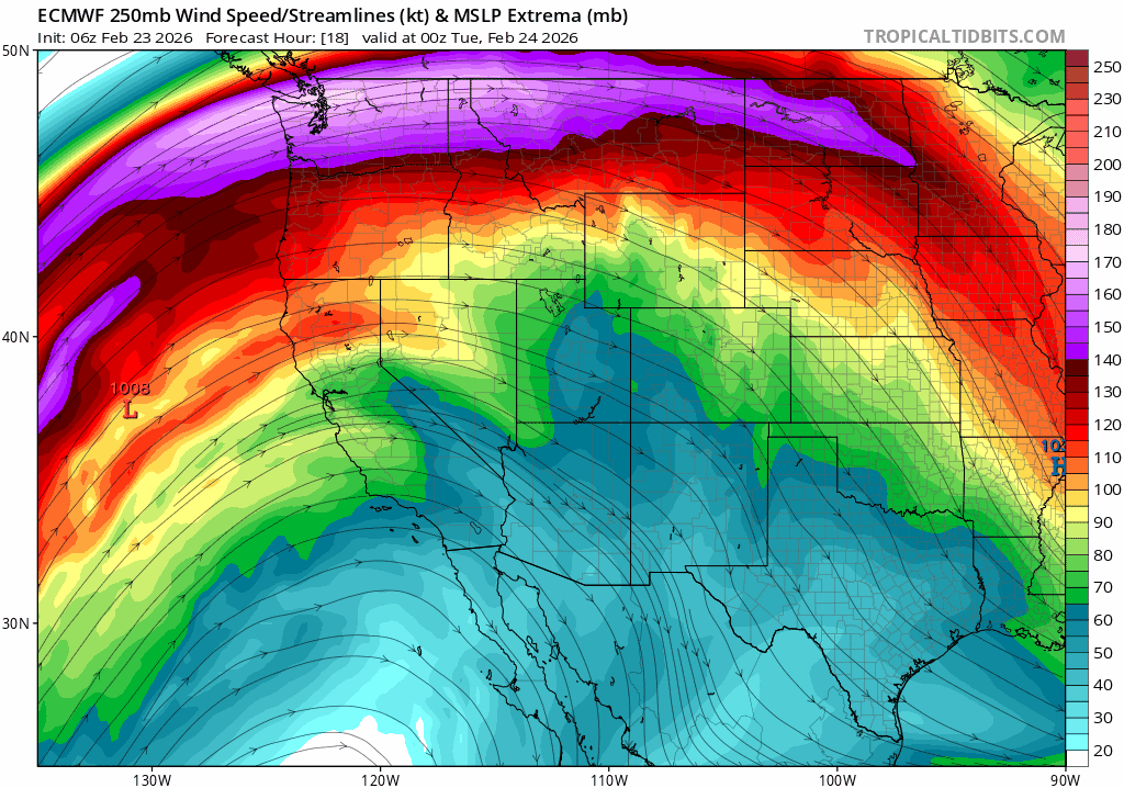
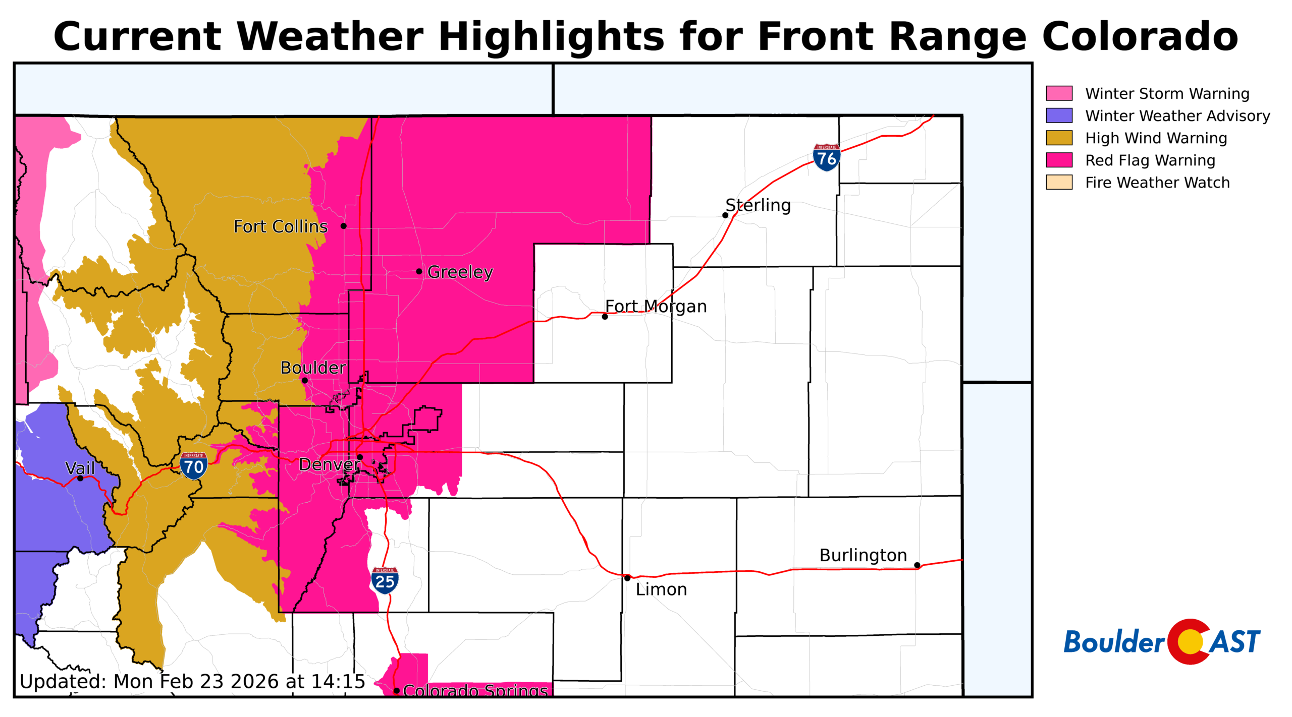
The first round of high winds will develop Tuesday morning across the Mountains and higher Foothills and continue into Tuesday evening. Gusts up to 90 MPH will be possible in this area. Fortunately, the atmosphere is lacking some ingredients for a strong mountain wave amplification, but this winds will still crash down over some portion of the Foothills (likely 7000-7500+ feet elevation). The lower elevations, including Boulder, look to be spared from this high wind risk on Tuesday, but it will still be breezy across the lower elevations, especially in the favored usual windy corridors where gusts may exceed 40 MPH at times. In general, winds will be gusting 20 to 30 MPH for most areas. With critical relatively humidities (8-12%), fire danger will be high!
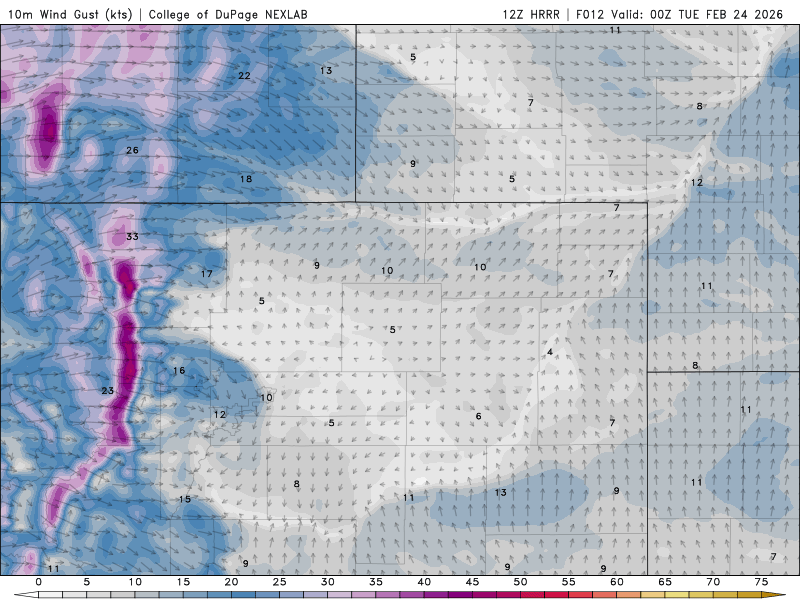
UPDATE: Red Flag Warnings have been issued for Tuesday for everywhere below 9000 feet elevation in the Foothills and Denver Metro area. Conditions are particularly dangerous in the low to middle Foothills (6000-8000 feet) where intense downslope winds will overlap low humidity.
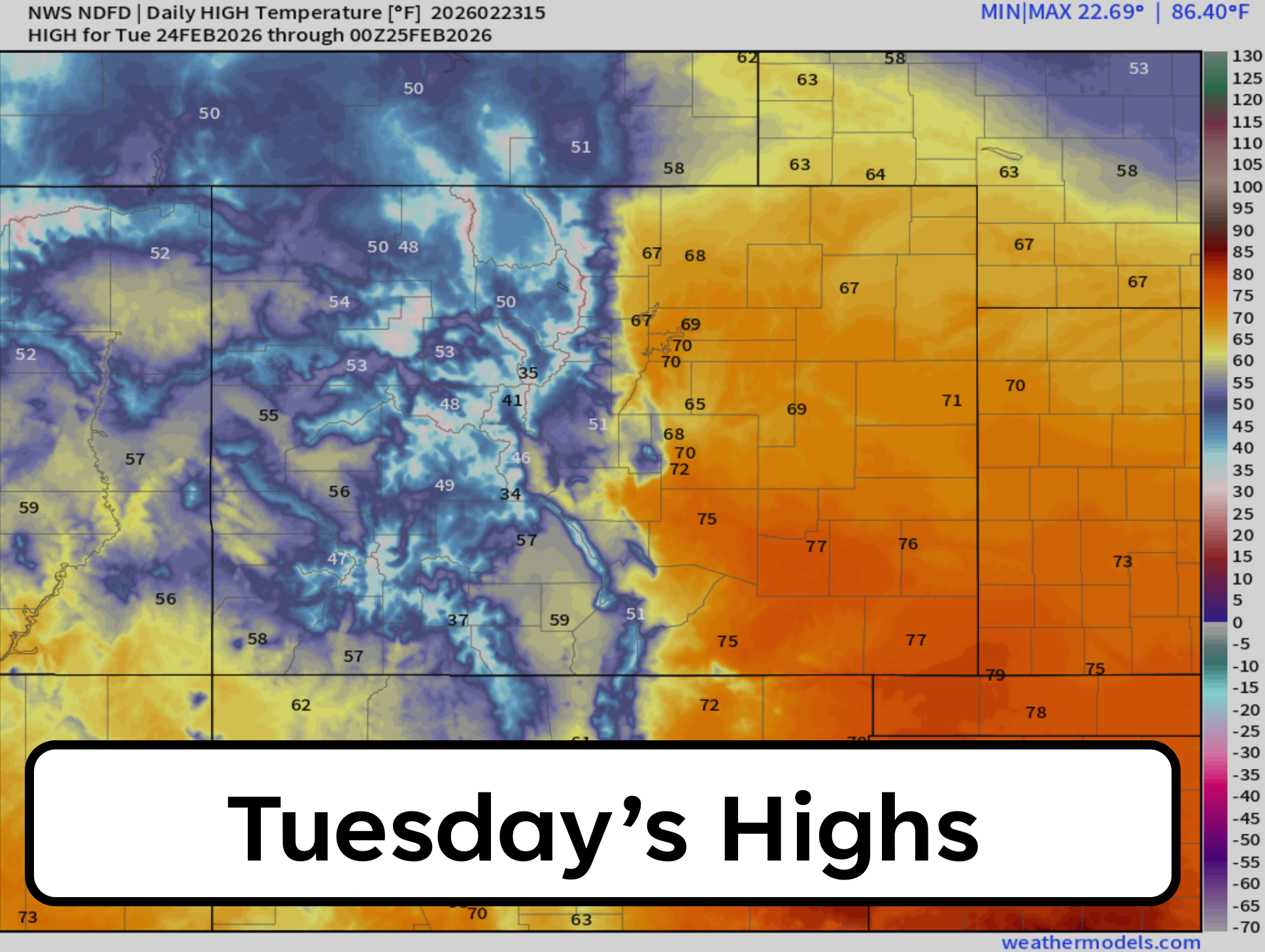
Highs push toward 70°F, with cloud cover the only thing standing between us and a record. Boulder’s record for February 24th is 72° (1981) and likely remains out of reach.
Gusty winds will continue on Wednesday as another shortwave passes along the Canadian border area leading to another spike in pressure gradients and wind speeds aloft during the day. Broader subsidence will be in-place on Wednesday across northeast Colorado, and that will lead to an eastward extension of the wind away from the terrain. Gusts of 30 to 50 MPH will be on the table for our entire area, with perhaps gusts up to 60 MPH accompanying a cold frontal boundary moving through during the evening. Brace now for a blustery Wednesday! Fortunately it looks like there will be enough moisture in the flow to keep fire danger in check (25%+), but that could change between now and midweek. Portions of the Front Range may need a High Wind Warning for Wednesday — this is most likely up along the Wyoming Border area.
Highs on Wednesday will be a tad cooler in the mid 60s across the Metro area, again with wave cloud cover limiting how warm we can get. As mentioned, a Pacific cold front will move through our area late in the day Wednesday from the northwest.
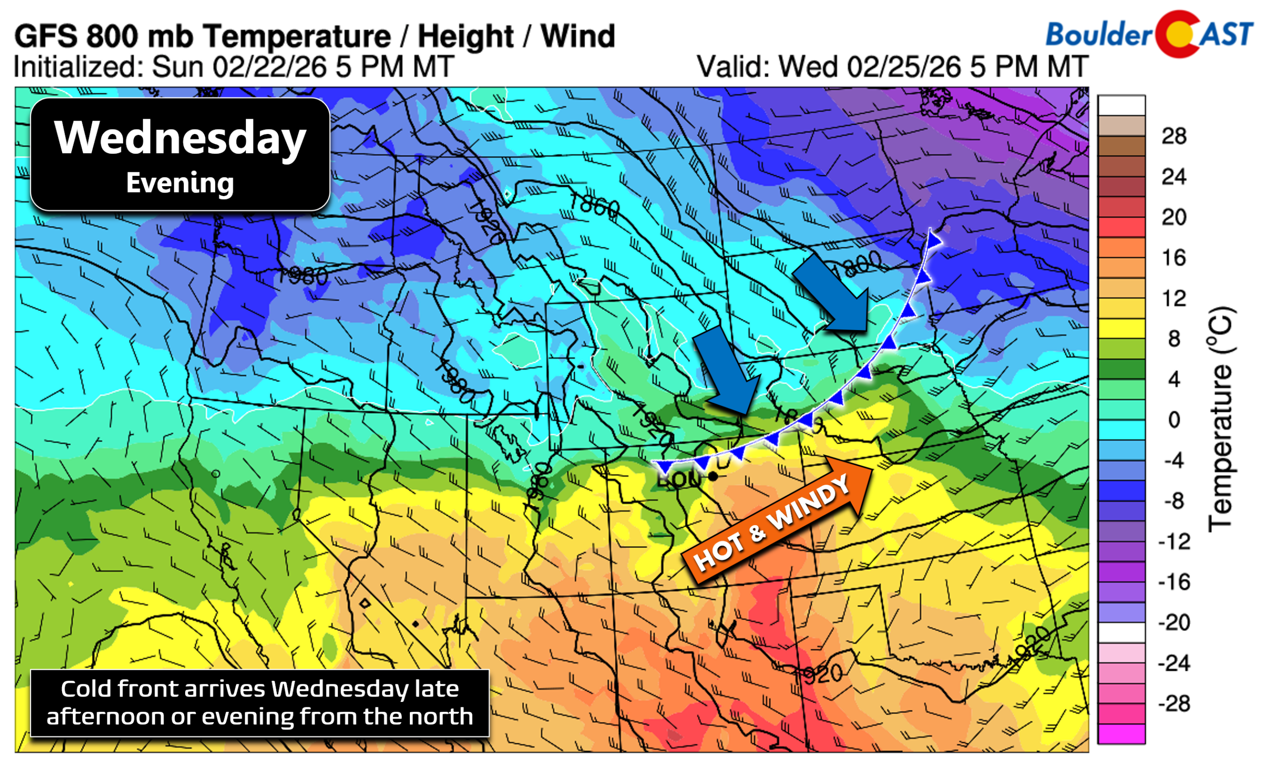
This front will offer up the only chance of precipitation for the week east of the Mountains, with a few isolated to scattered showers possibly forming Wednesday evening with up to a few hundredths of a inch of liquid possible. Temperatures look to be cold enough for any showers to remain rain, rather than snow, for the lower elevations.
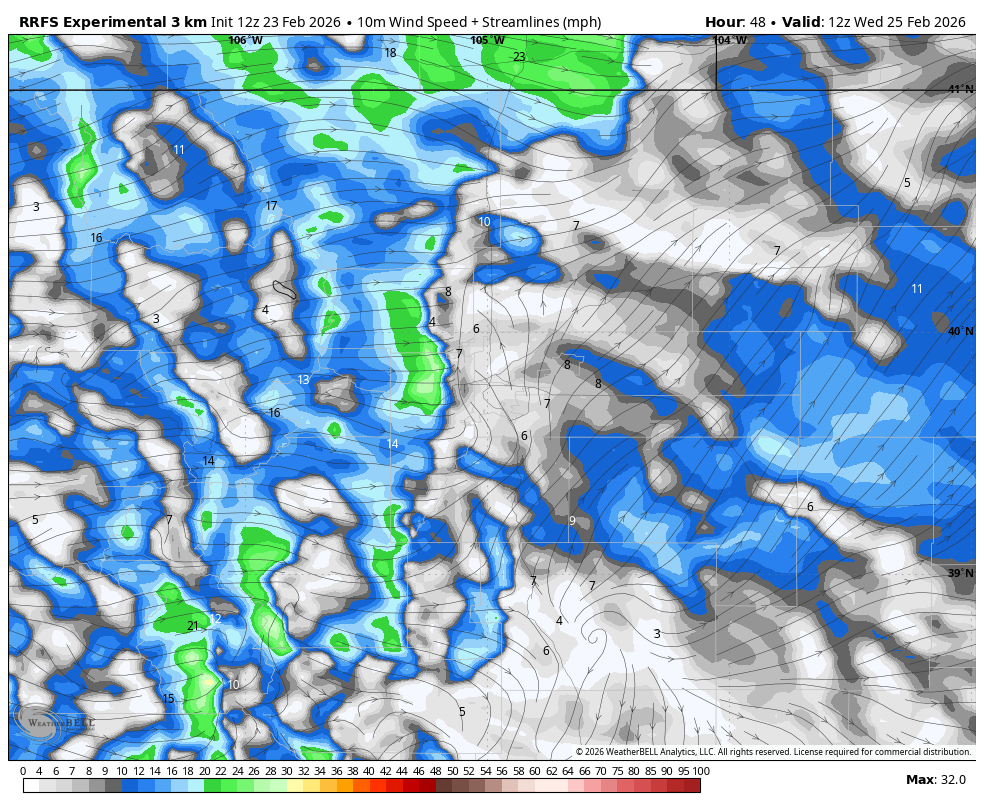
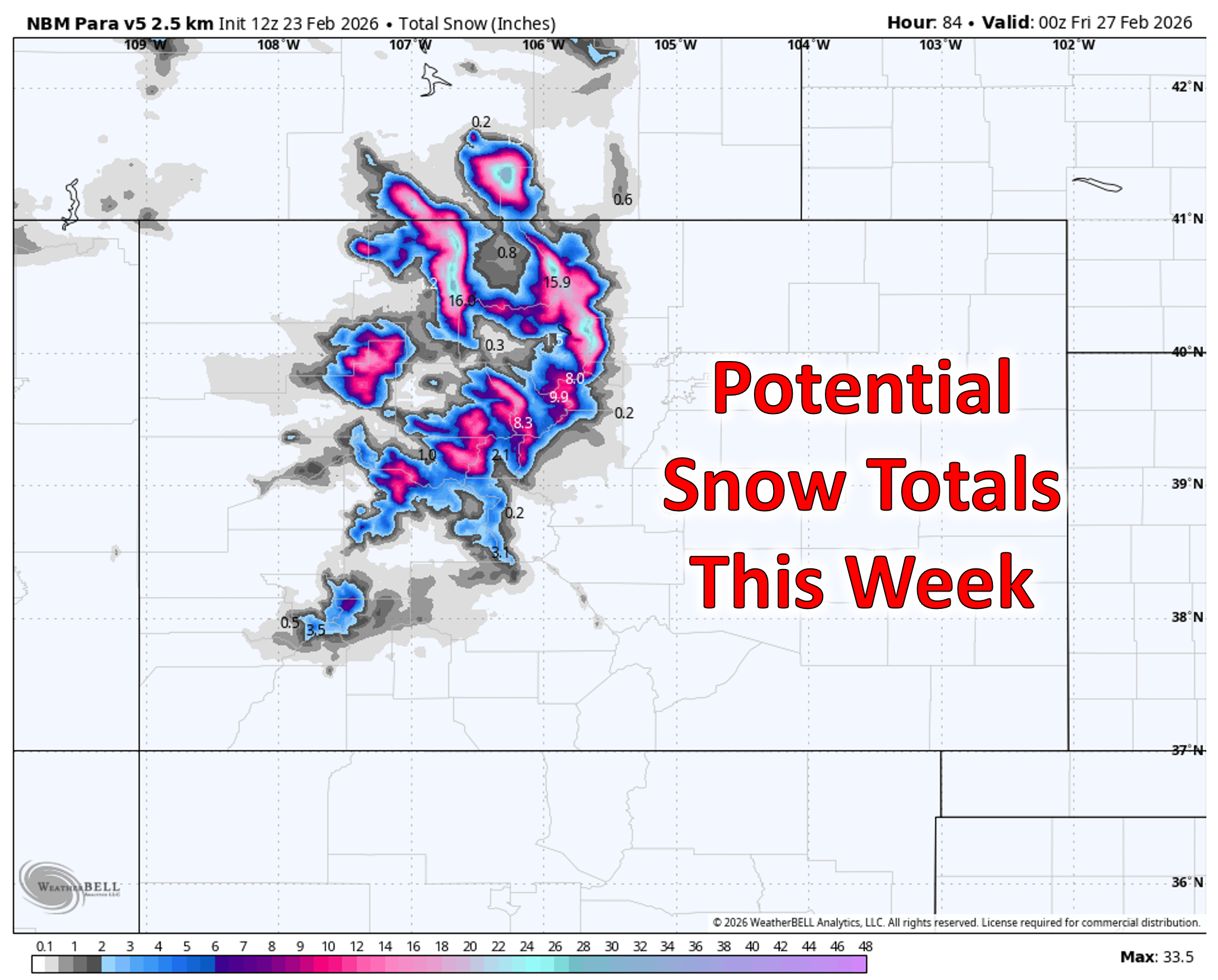
There is some positive news in this week’s forecast: the sagging jet also taps into Pacific moisture, delivering a healthy round of snow from Tuesday afternoon through Wednesday evening in the Mountains.
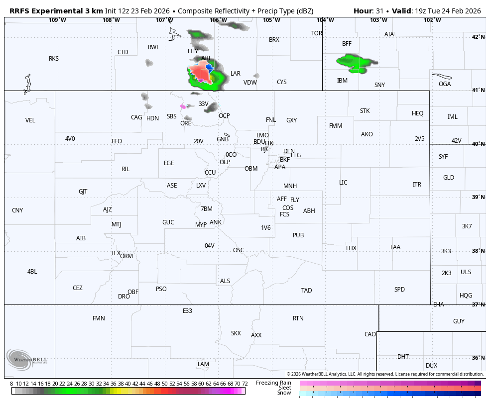
Simulated radar for Tuesday evening through Wednesday evening showing Mountain snow, chance rain on the Plains.
Colorado’s northern Mountains will be favored from this west-northwest flow pattern, with the greatest snowfall amounts in the Park Range near Steamboat where 8 to 16 inches are expected. Lesser but still hearty totals of 5 to 10 inches are expected in the Front Range Mountains from the Indian Peaks northward through Rocky Mountain National Park. The San Juans and Sangres of southern Colorado will largely miss out on the snow this week due to the flow direction and location of the moisture plume. With snow and wind overlapping, travel will become dicey Tuesday night through Wednesday night.
Thursday–Friday: Warm, Breezy, and Fire‑Prone (Again)
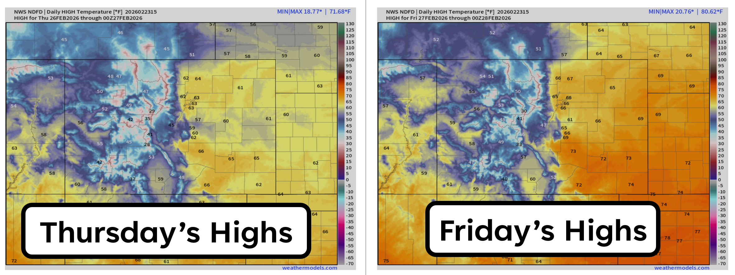
Despite a cold front moving through the area Wednesday evening, temperatures won’t cool off much to end the week as lee troughing will quickly develop east of the Rockies by Thursday afternoon. Thursday’s highs are still expected to be well above normal in the lower 60s. Friday will reach the mid to upper 60s. With the jet stream staying overhead, we’ll likely see a continuation of breezy conditions regionwide, with the potential for drier air to bump up fire danger. It’s too early to say if critical fire conditions will be widespread late in the week, or more localized, but keep an eye on the evolving forecast.
So yes, we’re staring down another five‑day stretch that looks nothing like February, but that’s been the theme of this “winter.”
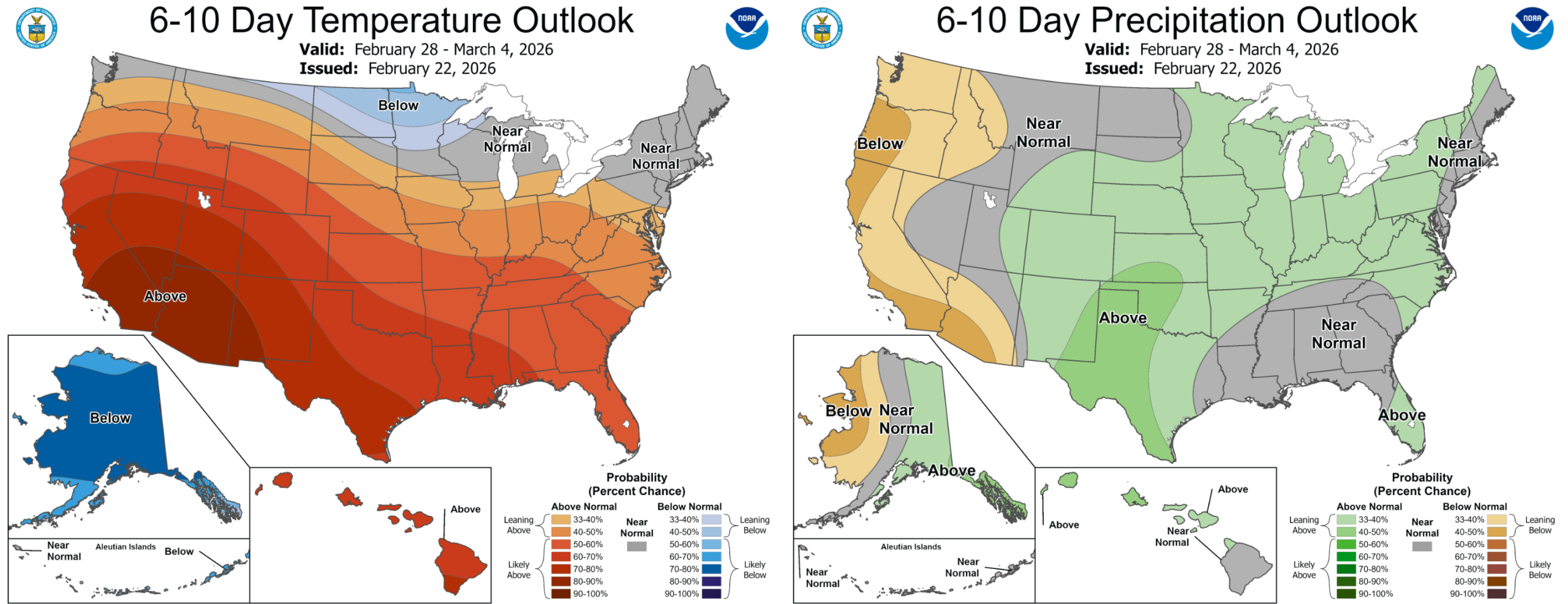
Extended Outlook: Early March, Same Story
Ridging holds across the West into early March, though the flow becomes more zonal. That should trim temperatures slightly, but we still expect above‑normal highs (55–65°F) most days. Additional Mountain snow chances remain on the table, but nothing that could deliver anywhere near enough.
Forecast Specifics:
Monday: Partly cloudy and quiet with highs in the middle 60s on the Plains and lower 50s in the Foothills. This will be the least windy day of the week.
Tuesday: Mostly cloudy and warm with highs in the upper 60s to near 70 degrees on the Plains with mid-50s in the Foothills. Gusty winds will develop during the day in the Mountains and High Foothills, gusting up to 90 MPH. Some winds may spill onto the lower elevations, but these gusts should be tamer of 20-35 MPH and more localized. Red Flag conditions will be present.
Wednesday: Mostly cloudy, warm and windy ahead of an evening cold front. Highs will reach the mid to upper 60s on the Plains with mid-50s in the Foothills. Expect gusts of 30 to 50 MPH to be common, with a chance of stronger gusts accompanying the late-day cold front. Fire danger will be elevated but perhaps not critical due to higher humidity. A few spotty rain showers may blow through Wednesday evening.
Thursday and Friday: Warm and breezy with highs in the low to middle 60s on the Plains and near 50 in the Foothills. These days could feature critical fire danger depending on how things evolve.
Weekend: Dry and quiet weather is expected for the weekend as well with highs ranging from 55 to 65 degrees. Winds may be breezy in spots with continued fire concerns and potential Red Flag Warnings.
DISCLAIMER: This weekly outlook forecast is created Monday morning and covers the entire upcoming week. Accuracy will decrease as the week progresses as this post is NOT updated. To receive daily updated forecasts from our team, among many other perks, subscribe to BoulderCAST Premium.
Go Premium, get all the perks.
Daily Forecast Updates
Get our daily forecast discussion every morning delivered to your inbox.
All Our Model Data
Access to all our Colorado-centric high-resolution weather model graphics. Seriously — every one!
Ski & Hiking Forecasts
6-day forecasts for all the Colorado ski resorts, plus more than 120 hiking trails, including every 14er.
Smoke Forecasts
Wildfire smoke concentration predictions up to 72 hours into the future.
Exclusive Content
Weekend outlooks every Thursday, bonus storm updates, historical data and much more!
No Advertisements
Enjoy ad-free viewing on the entire site.
Enjoy our content? Give it a share!


You must be logged in to post a comment.