The atmosphere is gearing up for a dramatic mid‑week pivot, and the Front Range is about to feel every bit of it. We start the week under a warm, bone‑dry ridge that will send temperatures soaring and fire danger spiking—especially by Wednesday, when downslope winds and exceptional dryness are set to collide. But just as quickly, the pattern will flip. A pair of incoming troughs will drag us into a cooler, unsettled stretch of weather heading into the weekend, with several chances for much‑needed moisture and even the prospect of a few snowflakes mixing in at times. It’s a true tale of two patterns this week! Read on for all the details.
This week’s highlights include:
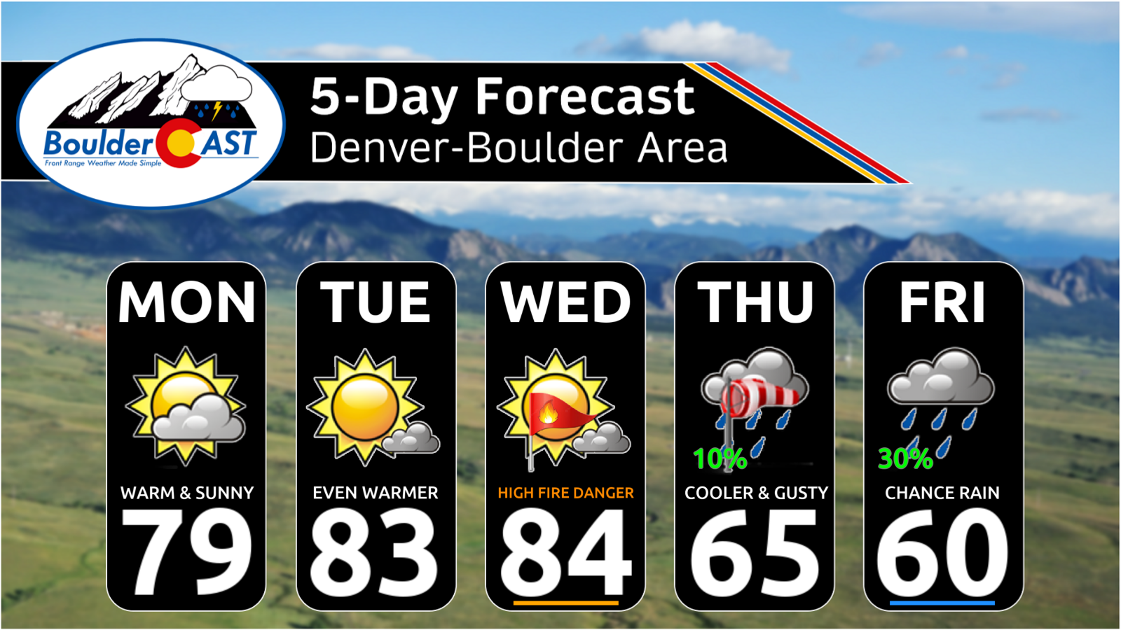
- 📈 Warm, dry ridge dominates through Wednesday, keeping temperatures very warm with no chances for precipitation.
- 🌞 Monday & Tuesday stay sunny and unseasonably warm, with highs in the upper 70s to middle 80s.
- 💨 Wednesday is the most concerning fire‑weather day, with strong downslope winds, single‑digit humidity, and Red Flag Warnings likely.
- 🔥 Critical fire danger will stretch from WY → CO → NM on Wednesday, with gusts 25–40 MPH across the Metro area.
- 🧊 A weak Pacific front arrives late Wednesday, cooling temps but offering little in the way of moisture for the Front Range.
- 🌄 Thursday turns cooler and windy, highs in the 60s, lingering fire danger, and only light mountain snow.
- 🌧️ Friday through the weekend shifts to a cooler, unsettled pattern, as two troughs interact and bring several days of showers.
- ❄️ Rain/snow mix possible at lower elevations daily, with highs in the 40s to 50s and much‑needed moisture sticking around into early next week.
DISCLAIMER: This weekly outlook forecast is created Monday morning and covers the entire upcoming week. Accuracy will decrease as the week progresses as this post is NOT updated. To receive daily updated forecasts from our team, among many other perks, subscribe to BoulderCAST Premium.

Go Premium, get all the perks.
Daily Forecast Updates
Get our daily forecast discussion every morning delivered to your inbox.
All Our Model Data
Access to all our Colorado-centric high-resolution weather model graphics. Seriously — every one!
Ski & Hiking Forecasts
6-day forecasts for all the Colorado ski resorts, plus more than 120 hiking trails, including every 14er.
Smoke Forecasts
Wildfire smoke concentration predictions up to 72 hours into the future.
Exclusive Content
Weekend outlooks every Thursday, bonus storm updates, historical data and much more!
No Advertisements
Enjoy ad-free viewing on the entire site.
The week ahead: A tale of two patterns
The atmosphere is about to pull a hard left turn midweek, splitting the upcoming stretch into two very different regimes for the Front Range. We start warm, dry, and increasingly wind‑driven under a stout ridge… then flip into a cooler, unsettled, multi‑day trough pattern heading into the weekend.
The warm & dry tale
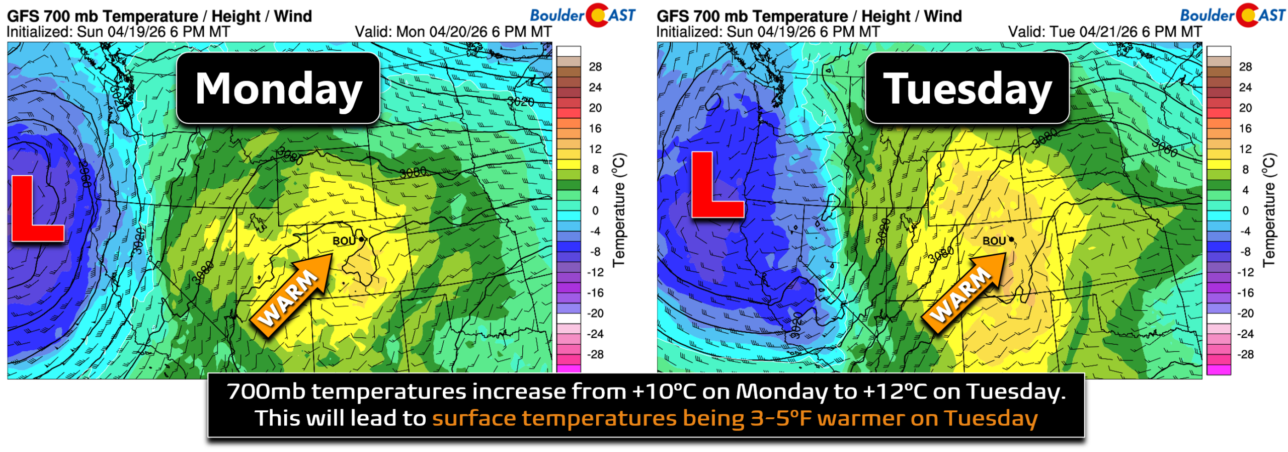
Directly under the core of the ridge, high temperatures on Monday will reach the upper 70s to near 80° throughout the Boulder-Denver area with light winds. Morning cloud cover will give way to mostly sunny skies.
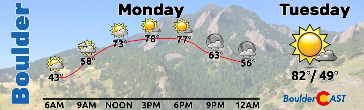
The setup doesn’t change much for Tuesday, with continued sunshine and slightly warmer readings expected as 700mb temperatures increase from +10° up to +12°C, with surface temperature reflections pushing into the low to middle 80s in the Front Range.
Wednesday is the transition day—and the most concerning one.
A compact shortwave trough that was offshore from California earlier in the week will move inland and trek into the northern Rockies during the day, with Colorado catching increasingly strong downslope flow as it passes by to our north.
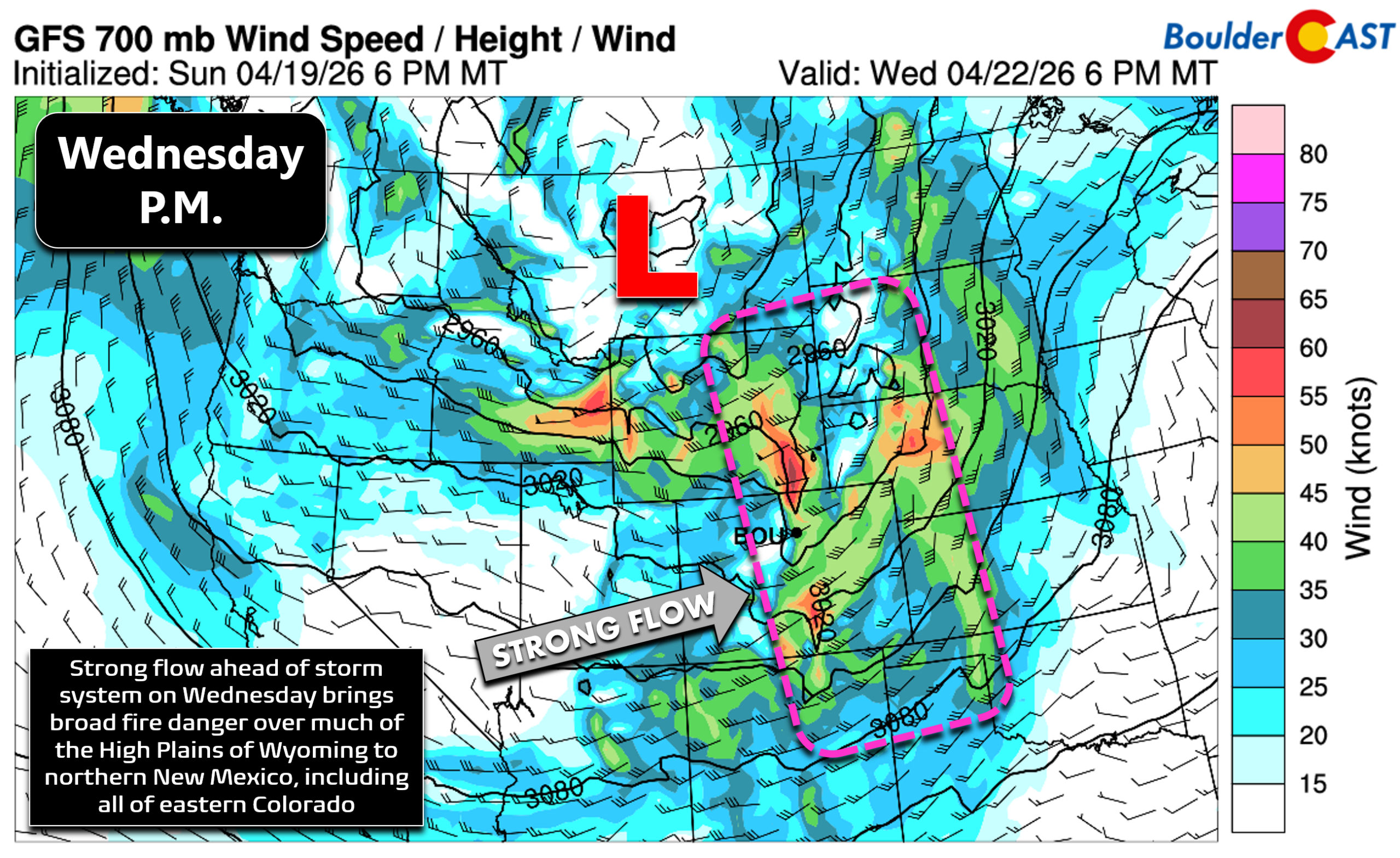
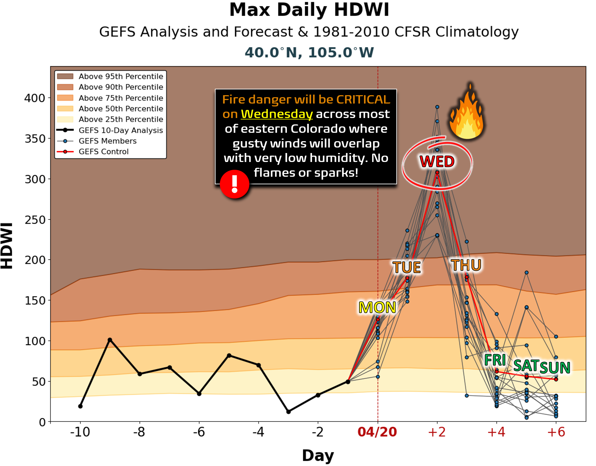
Wednesday is shaping up to be the most dangerous day of the week with widespread critical fire danger throughout much of the western High Plains from Wyoming, eastern Colorado and into northern New Mexico. The Hot-Dry-Windy Index (HDWI) will be near all time highs for late April in our area Wednesday speaking to the degree of fire risk. As a reminder, HDWI is a simple fire‑weather metric that multiplies low‑level maximum wind speed by maximum vapor‑pressure deficit to highlight days when atmospheric conditions are especially favorable for dangerous fire behavior.
Wednesday’s temperatures will top out in the low to middle 80s again with mostly sunny skies. Afternoon gusts will reach 25 to 40 MPH throughout the Denver Metro area and Foothills alongside single digit relative humidities, solidifying the threat rapidly spreading fires should any ignitions occur. Red Flag Warnings are all but guaranteed for Wednesday in our area! Please use extreme caution!
The cooler, unsettled tale
A Pacific front sweeps across the state Wednesday evening, but it’s moisture‑starved and largely downslope‑dominated for the Front Range. The northern Mountains may squeeze out a couple inches of snow, but the Boulder‑Denver corridor stays mostly dry.
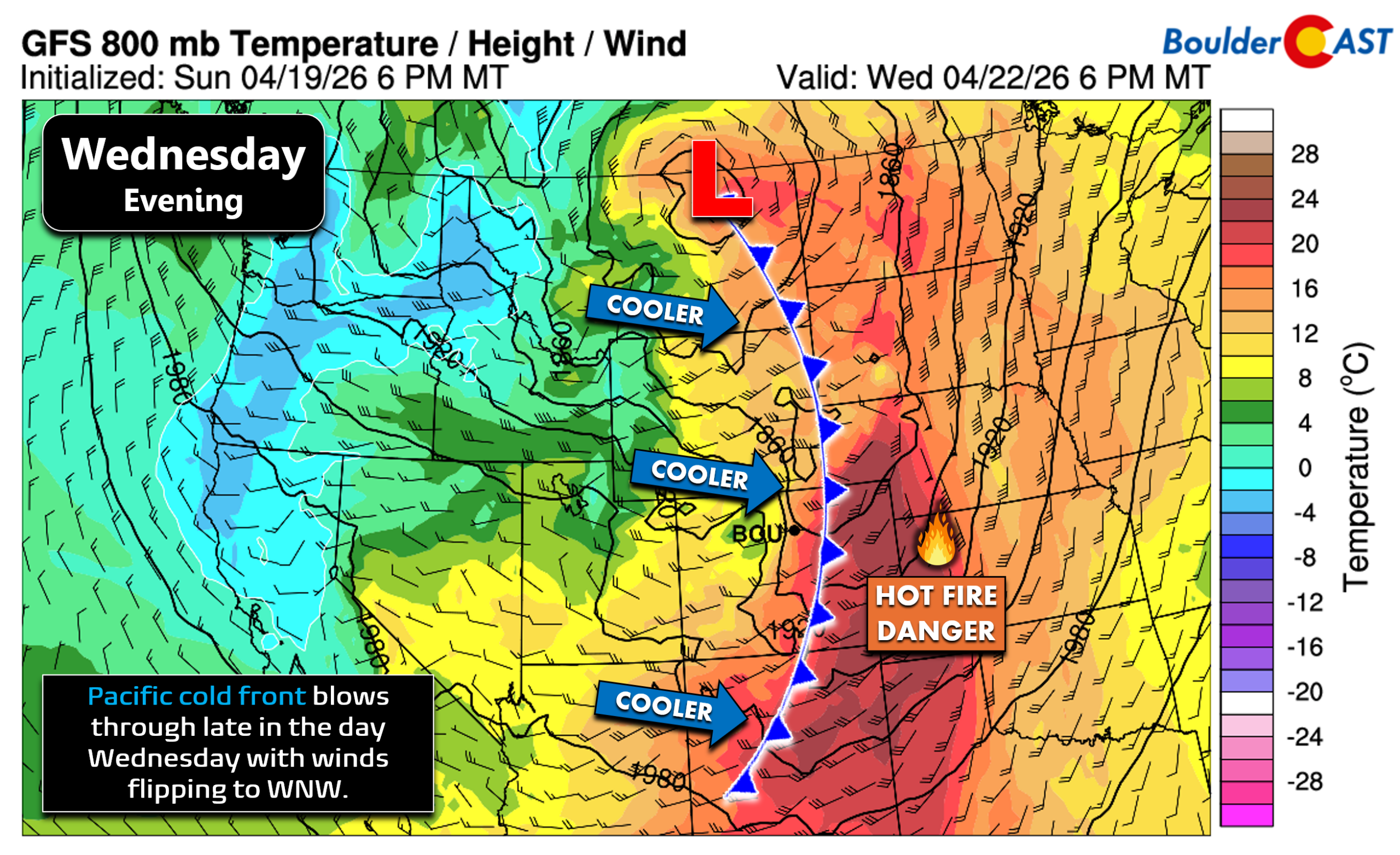
Behind the front, the air mass cools but remains fairly dry. We could see fire danger persist in some areas into Thursday, though not nearly as bad as it will be the day prior. Thursday’s temperatures will fall into the 60s with blustery WNW winds gusting over 30 MPH possible. We’ll include a very slight chance of a stray rain shower later in the day, but most/all of the light precipitation on Thursday will stay in the High Country with just pesky wind for the lower elevations.
Friday into the weekend turns unsettled
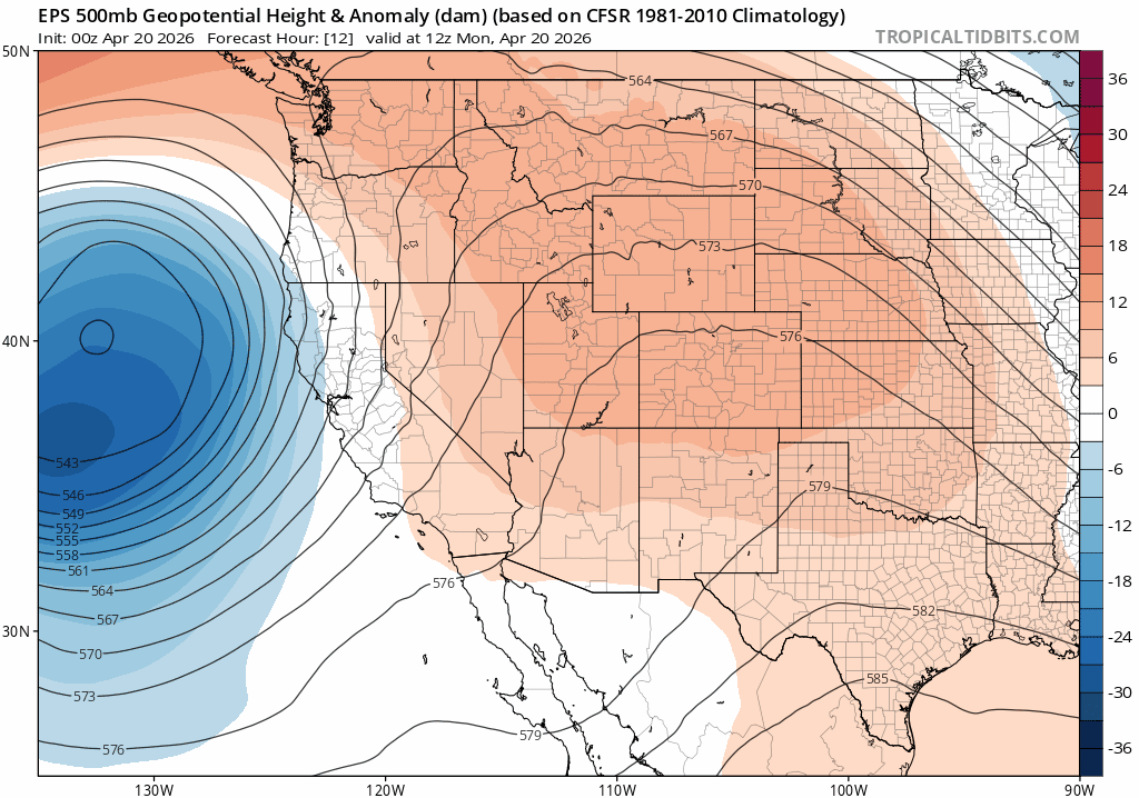
Friday into the weekend is when the most unsettled period of weather will unfold for the area as a secondary trough pushes ashore from California, while at the same time joining forces with another potential shortwave dropping out of western Canada. How these two features phase together—or fail to—remains uncertain, and current ensemble guidance reflects that. But the broad outcome is clear:
- Much cooler temperatures (40s and 50s for highs)
- Several days of unsettled, showery weather
- Daily chances for precipitation across much of Colorado
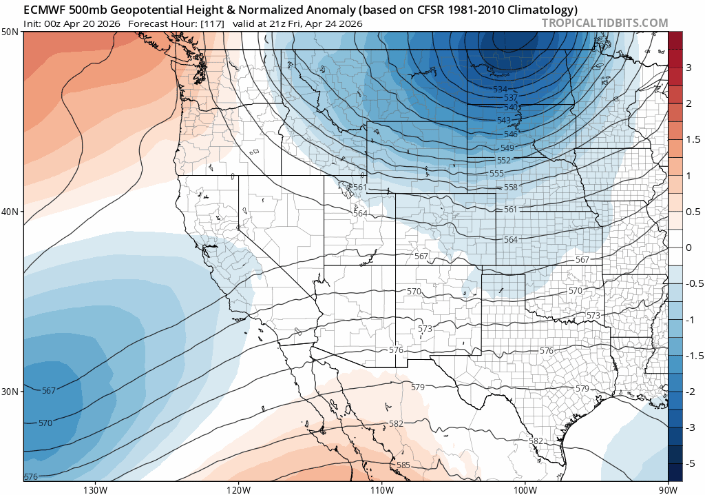
Euro 500mb height anomaly forecast for Friday into Monday showing the unsettled, troughy pattern over Colorado
While nothing looks all that impressive at this time, the persistence is what matters. Multiple cool, showery days in a row are exactly what our region needs to help chip away at dryness and reduce fire danger. And yes, temperatures could be cold enough for some of this precipitation to fall as snow down low. The airmass won’t be nearly as cold as we had alongside this past Friday’s heavy snow burst, but we could see minor, slushy accumulations occur intermittently over the weekend into early next week mixed in with the rain at times.
The European ensemble precipitation forecast animation below shows potential amounts through the middle of next week (April 29th). While there isn’t one particular big storm in the works right now, the successive chances for daily rain and snow showers Friday and beyond could add up — with this ensemble’s mean showing ~0.5 to 1.0 inches of precipitation over time in the Boulder/Denver area, with higher amounts in the Mountains!
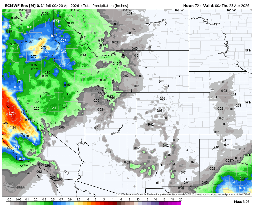
Euro ensemble mean precipitation forecast animation through Wednesday April 29th.
We end the week on a cooler note Friday with a chance for scattered showers, lots of clouds and temperatures staying cool around 60°.
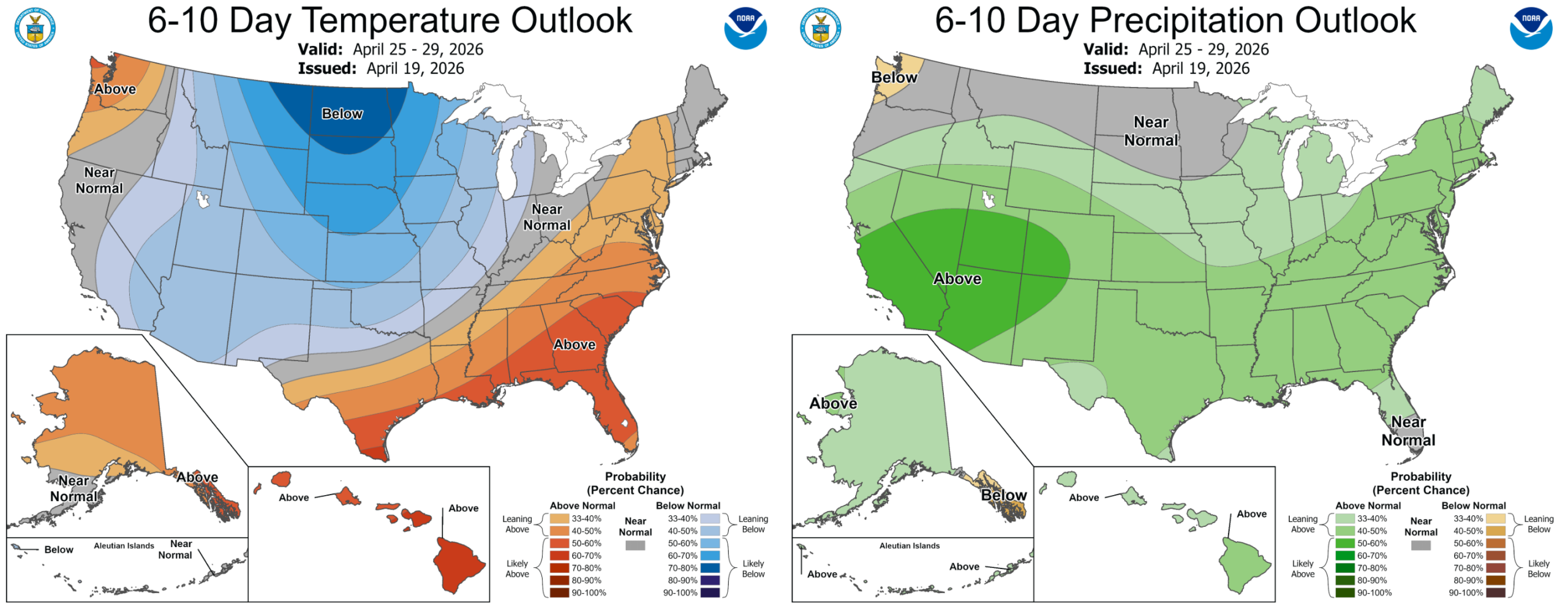
The cooler, at least somewhat wetter pattern is set to linger into early next week—and possibly longer into early May depending on how the longwave Western troughiness evolves (it’s looking decent, fingers crossed!). For the first time in a while, the Climate Prediction Center is painting blue and green over Colorado. After the winter and spring we’ve had, this is certainly a welcome shift!
Forecast Specifics:
Monday: Decreasing clouds, warm and quiet. Highs reach the upper 70s on the Plains with middle 60s in the Foothills.
Tuesday: Mostly sunny and warm with highs in the lower to middle 80s on the Plains with near 70° in the Foothills.
Wednesday: Warm and windy with high fire danger regionwide. Afternoon gusts of 25 to 40 MPH possible with humidities of 5 to 12% leading to likely Red Flag Warnings. A late-day gusty cold front will bring light snow to the Mountains.
Thursday: Cooler with pesky west-northwest winds gusting 20 to 30 MPH leading to elevated fire danger. Skies will be partly clouds with a slight chance for an isolated late-day rain shower. Highs reach the middle 60s on the Plains with lower 50s in the Foothills.
Friday: Staying cool with mostly cloudy skies and chances for some rain showers during the day. Temperatures will top out around 60° on the Plains with upper 40s in the Foothills.
Weekend: Staying cool and unsettled across the Front Range with highs in the upper 40s to middle 50s under mostly cloudy skies. Rain showers, perhaps changing over to snow at times, will be around intermittently through the weekend into early next week.
DISCLAIMER: This weekly outlook forecast is created Monday morning and covers the entire upcoming week. Accuracy will decrease as the week progresses as this post is NOT updated. To receive daily updated forecasts from our team, among many other perks, subscribe to BoulderCAST Premium.
Go Premium, get all the perks.
Daily Forecast Updates
Get our daily forecast discussion every morning delivered to your inbox.
All Our Model Data
Access to all our Colorado-centric high-resolution weather model graphics. Seriously — every one!
Ski & Hiking Forecasts
6-day forecasts for all the Colorado ski resorts, plus more than 120 hiking trails, including every 14er.
Smoke Forecasts
Wildfire smoke concentration predictions up to 72 hours into the future.
Exclusive Content
Weekend outlooks every Thursday, bonus storm updates, historical data and much more!
No Advertisements
Enjoy ad-free viewing on the entire site.
Enjoy our content? Give it a share!


You must be logged in to post a comment.