

This Christmas will be a scorcher across the Front Range with temperatures soaring towards record highs near 70 degrees, but snow is often part of the equation here on Christmas, whether falling or on the ground. We take a broader look at White Christmas occurrences in Boulder’s historical record and discuss why Christmas Day, out of all days, has one of the highest probabilities of snow on the ground here.

Go Premium, get all the perks.
Daily Forecast Updates
Get our daily forecast discussion every morning delivered to your inbox.
All Our Model Data
Access to all our Colorado-centric high-resolution weather model graphics. Seriously — every one!
Ski & Hiking Forecasts
6-day forecasts for all the Colorado ski resorts, plus more than 120 hiking trails, including every 14er.
Smoke Forecasts
Wildfire smoke concentration predictions up to 72 hours into the future.
Exclusive Content
Weekend outlooks every Thursday, bonus storm updates, historical data and much more!
No Advertisements
Enjoy ad-free viewing on the entire site.
What counts as a “White Christmas”?
Meteorologists actually recognize two definitions for the occurrence of a White Christmas:
- Snow depth definition (official): At least 1″ of snow present on the ground at any point during December 25th. This is the standard used by the National Climatic Data Center (NCDC).
- Snowfall definition (preferred): At least 0.1″ of snow must fall and accumulate on Christmas Day itself.
Let’s be honest—most of us would rather see fresh flakes flying as we open gifts and enjoy holiday meals. Lingering, dirty snowpack doesn’t exactly scream holiday cheer. However, today’s discussion will generally focus on the official definition (snow on ground).
Climatology of Christmas Snow in Boulder
The NCDC climatology map shows the Front Range having about a 40% chance of having 1″ of snow on the ground for Christmas. Odds climb to nearly 100% in the western Mountains on Colorado, where deep snowpack is the norm this time year. Remember, this is long-term climatology, not a forecast this year.
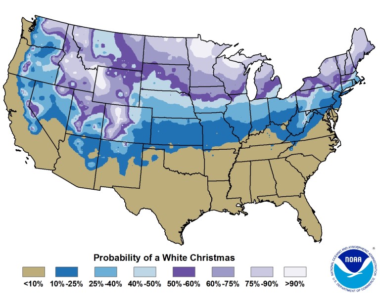
Percentage chance of having one inch of snowfall on the ground on Christmas (Credit: NOAA).
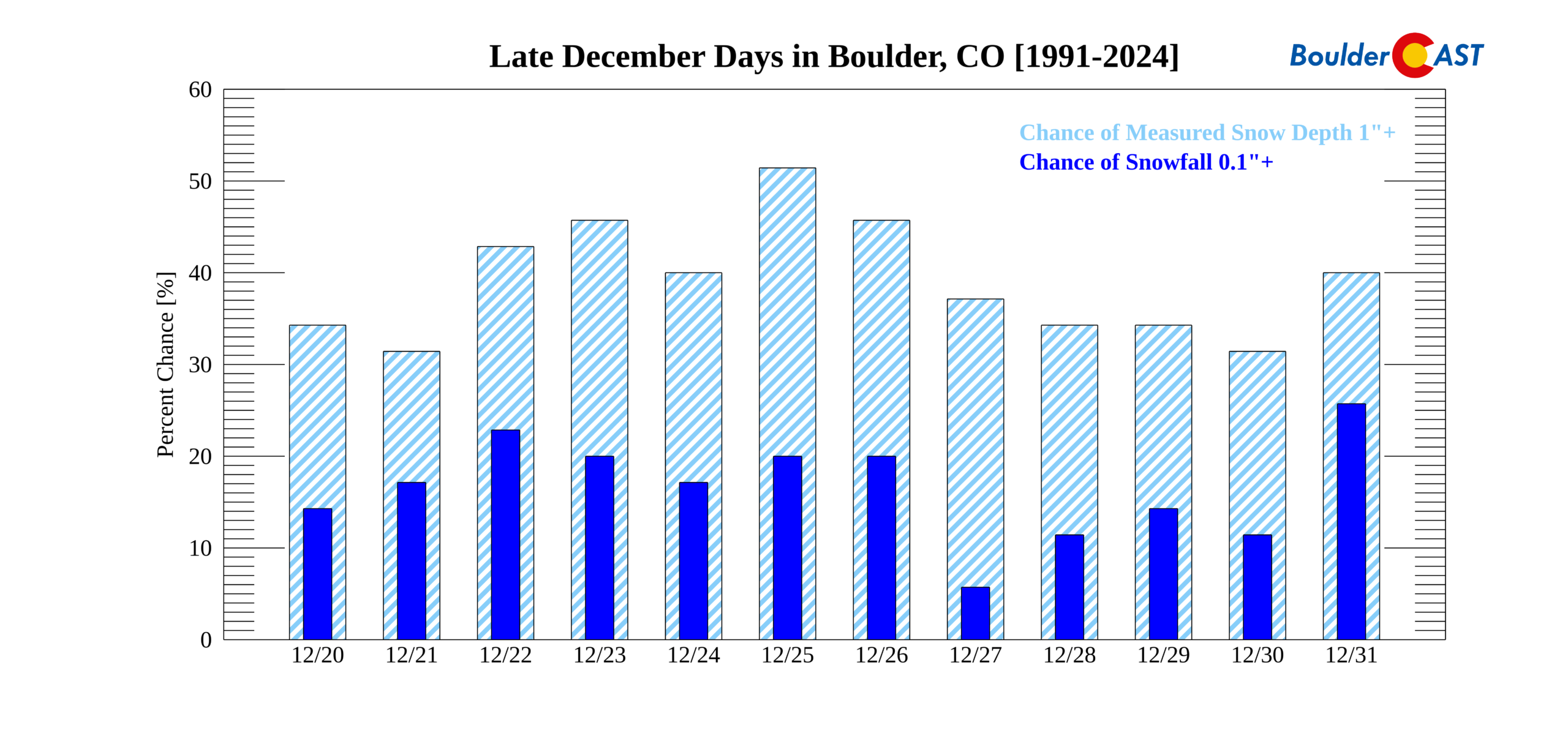
Looking at Boulder specifically, the data suggests we have been relatively more “fortunate” in recent decades compared to the longer historical record:
- Last 30 years (1991–2020):
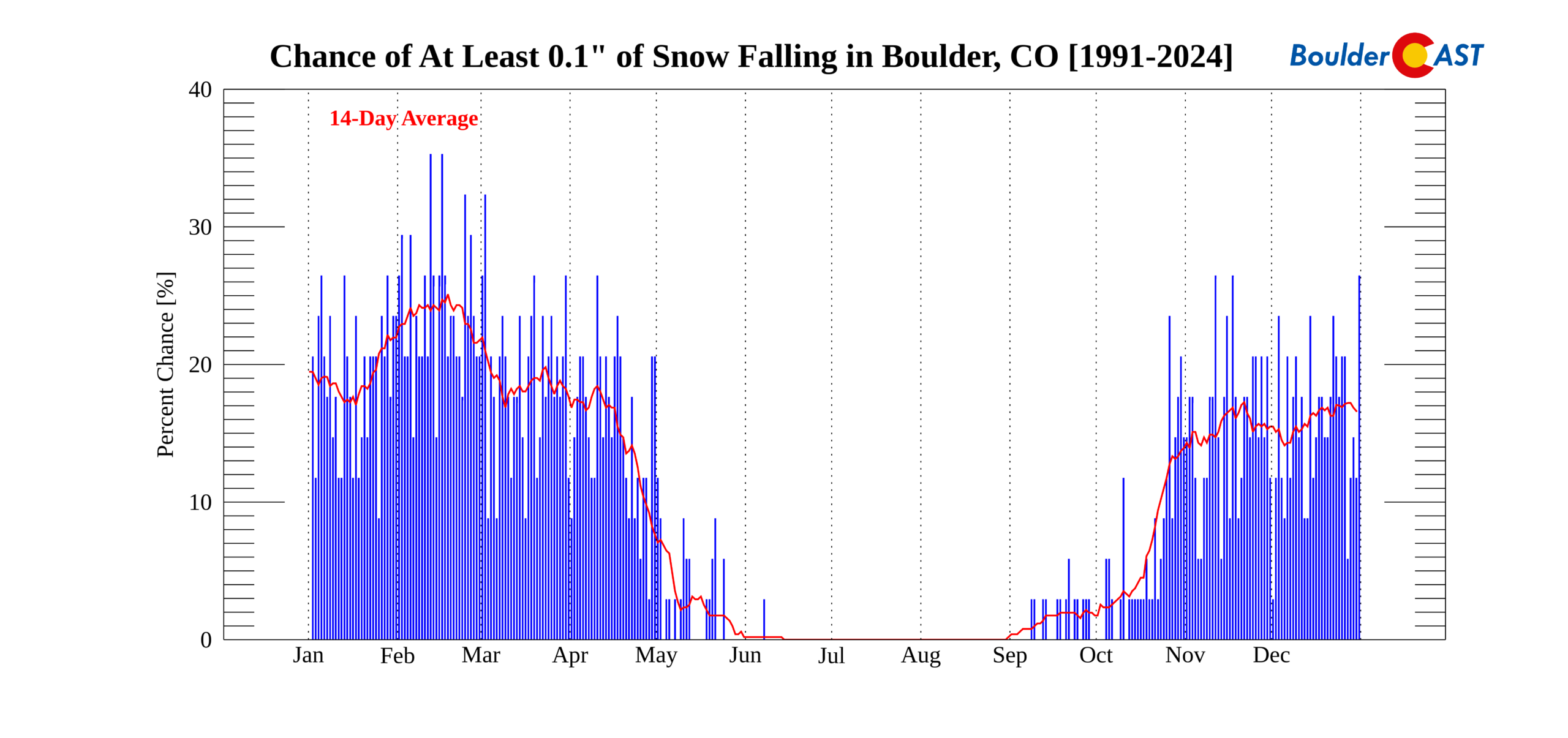
- 21% chance of measurable snowfall on Christmas Day
- 53% chance of at least 1″ of snow depth on the ground
- Long-term averages (1940s–present):
- 17% chance of snowfall
- 37% chance of snow depth
Christmas Day snowfall and depth by year are shown in the graphic below (click to zoom). We haven’t had a hint of the white stuff on December 25th since 2023.
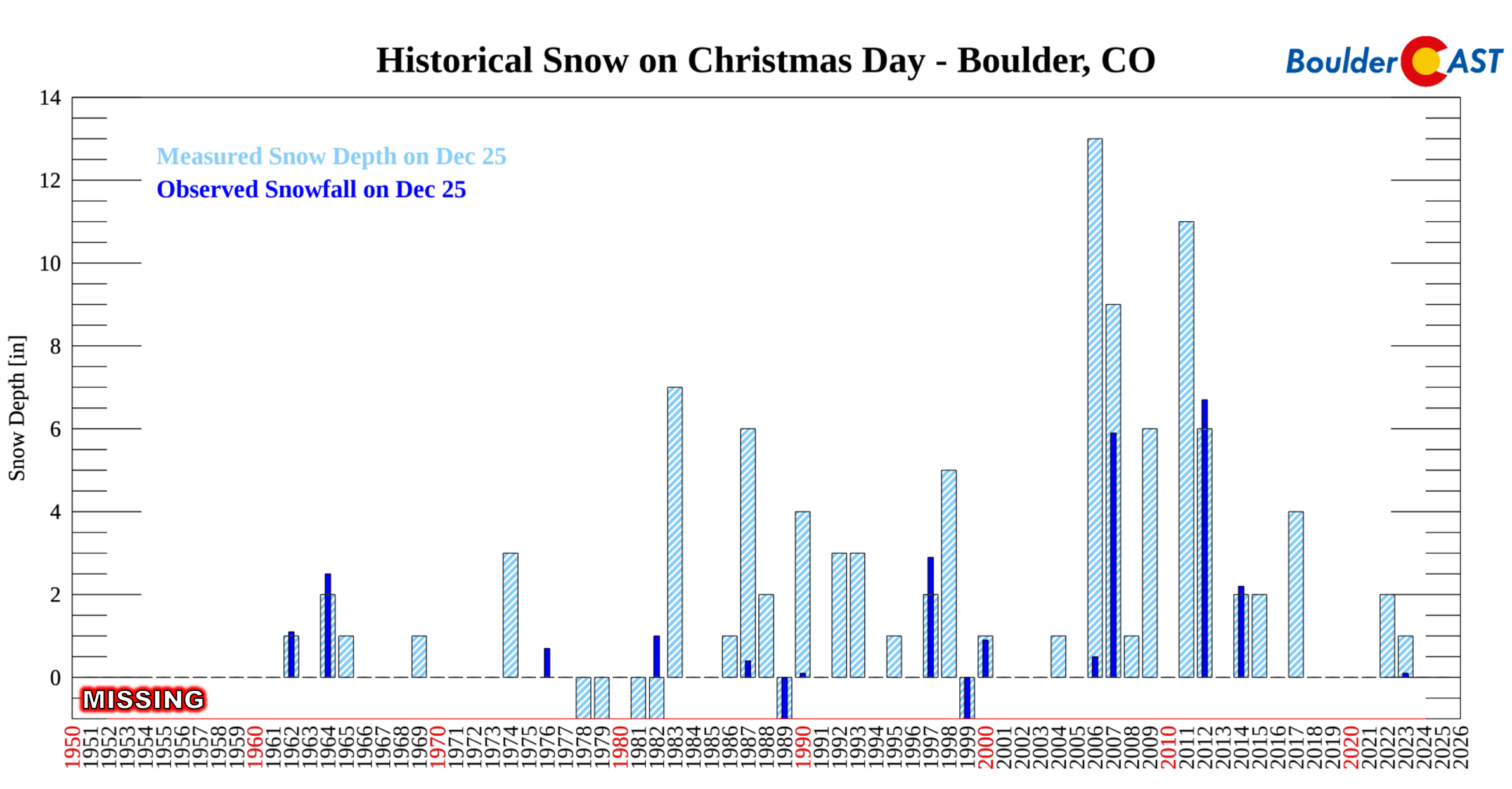
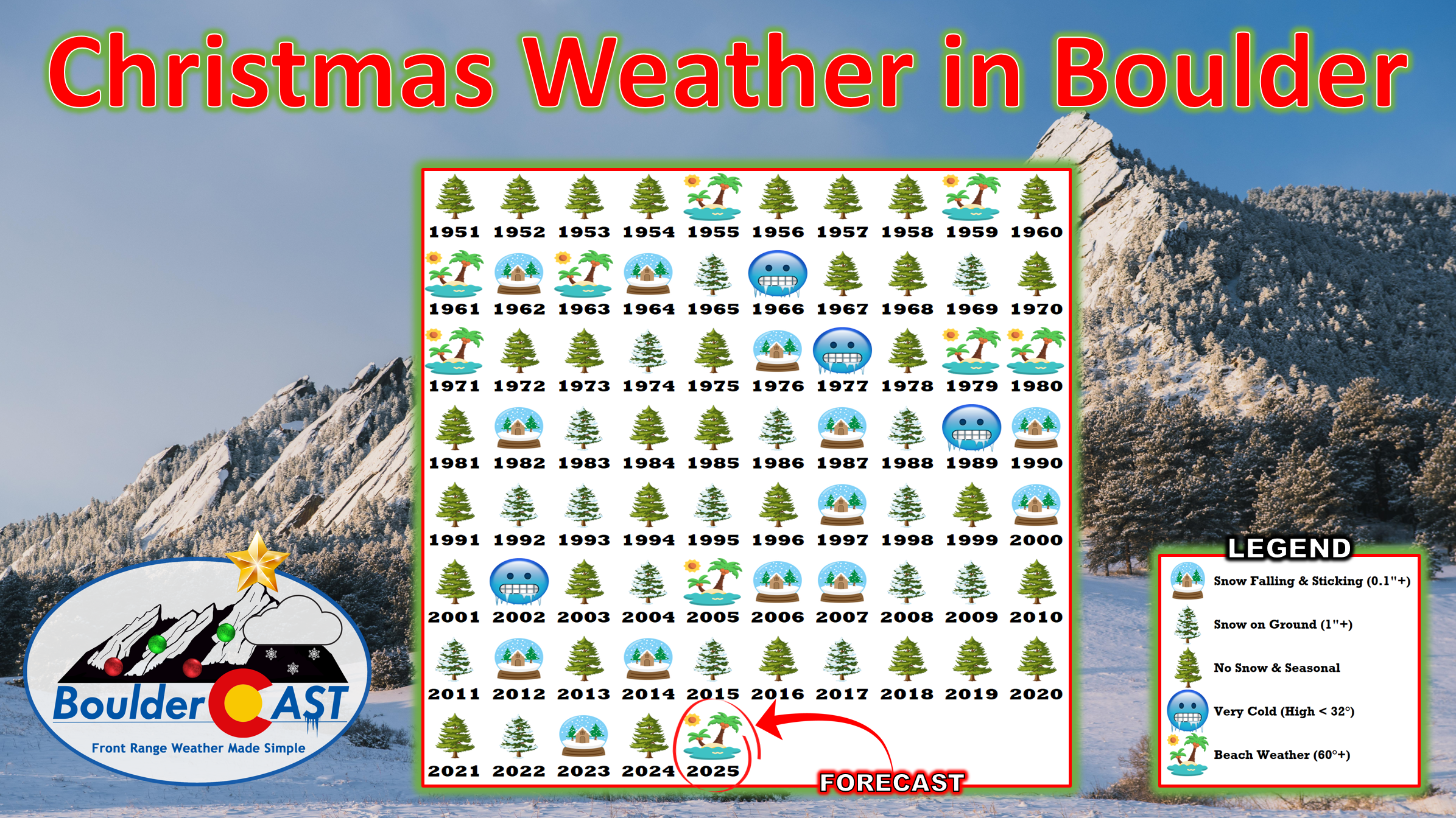
Now this is the same data, presented a bit differently:
Here are some additional Santa Day tidbits for Boulder…
Top 5 Snow Depths on Christmas Day Since 1948:
- ~15″(1982, unofficial)
- 13″ (2006)
- 11″ (2011)
- 9″ (2007)
- 7″ (1983)
Top 5 Snowfalls on Christmas Day Since 1948:
- 6.7″ (2012)
- 5.9″ (2007)
- 2.9″ (1997)
- 2.5″ (1964)
- 2.2″ (2014)
How the Last 10 Christmas Days Played Out in Boulder:
- 2024: A deluge of rain fell on parts of the Denver Metro area during the evening hours, with temperature remaining just a hair too warm for any snowflakes to mix in. This resulted in the first “Rainy Christmas” in Boulder since 1942. 1 to 3 inches of snow fell above 7000 feet, giving our higher elevation readers a true white Christmas despite the lower elevation rain.
- 2023: A fairly mild winter storm moved through on Christmas Eve producing about 2″ of snow in Boulder. This thin layer of snow stuck around until Christmas Day giving Boulder a white Christmas. 4-10″ of snow fell in the Foothills.
- 2022: An historic Arctic outbreak slammed the Front Range three days before Christmas with one of our most rapid temperature drops of all-time and some other record-breaking cold/snow aspects. This Arctic blast led to 3-8″ of snow accumulation across the Metro area and Foothills. Stuck in the Arctic chill, this snow persisted on the ground for several days to give most of us a white Christmas. Our actual Christmas Day weather was mild in the 50s with gusty downslope winds and sunshine.
- 2021: A significant atmospheric river event unfolded across Colorado in the days just before Christmas with two to four feet of snow falling across the San Juan Mountains. The moisture-infused atmospheric river was too warm for snow in the Denver Metro area leading to just a few rain showers on Christmas Eve. Christmas Day was sunny in the 50s with occasional gusty winds. Just one week later the Marshall Fire tragedy stuck following a record dry summer and autumn in Boulder County.
- 2020: High pressure dominated our weather on Christmas and the days prior leading to a definitively brown Christmas with highs nearly reaching 60 degrees with lots of sunshine.
- 2019: December 2019 was one of the least snowy December’s in Boulder history with only 3.4″ for the entire month. Christmas Day was no exception with no snow falling or present on the ground. There were quiet conditions in Boulder and partly sunny skies. The high was 50 degrees.
- 2018: No snow fell in Boulder for nearly three weeks leading up to Christmas 2018 and the day itself was rather mundane. The high was 44°F with mostly sunny skies and light winds.
- 2017: Two quick-moving light snow events dropped 7″ of new snow in Boulder in the few days leading up to Christmas 2017. With temperatures largely staying below 40 degrees, this snow persisted to Christmas Day with a depth of 4″ reported on the ground. No snow fell in Boulder on Christmas, though a favorable northwest flow pattern produced widespread accumulating snow in the Mountains this day. The high in Boulder was a cold 26°F after a morning low of 11°F.
- 2016: A strong storm system was pushing across Colorado/Wyoming this year, but the track was too far north and the Front Range got downsloped. A few convective rain/snow showers were reported in eastern Colorado, including brief thundersnow at DIA (no accumulation) which resided in the warm sector in the morning. However, it was dry and extremely windy in Boulder with gusts up to 80MPH around the area Christmas evening! The 4″ of snow that fell about a week before Christmas 2016 was long gone so there was no snow on the ground this year either.
- 2015: Light snow fell on the evening of Christmas 2015 and spilled over into the 26th totaling 2.6″. However, since Boulder’s record-keeping for the date ends at 6PM local time, there was no snow “officially” reported for the day. There was snow on the ground though as nearly a foot of snow pummeled Boulder on December 15th and due to seasonally chilly conditions leading up the holiday, 2″ of that nasty snow remained on the ground in Boulder for Christmas.
Why Christmas Day Has High Odds of Snow on the Ground Here
Closer examination shows that Christmas Day ranks second overall for snow depth odds in Boulder (53%), just behind January 4th (56%).
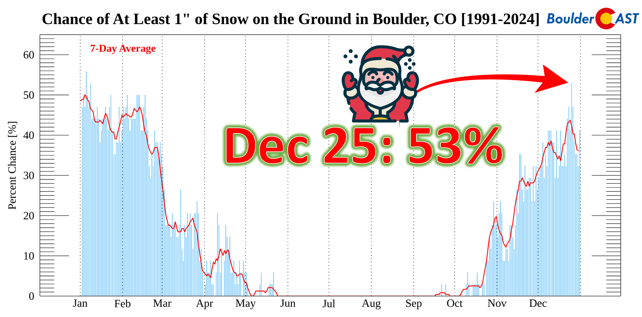
But this isn’t because it snows more often on Christmas. In fact, peak snowfall chances occur in February, March, and early April.
Instead, the higher odds of snow depth are tied to other factors:
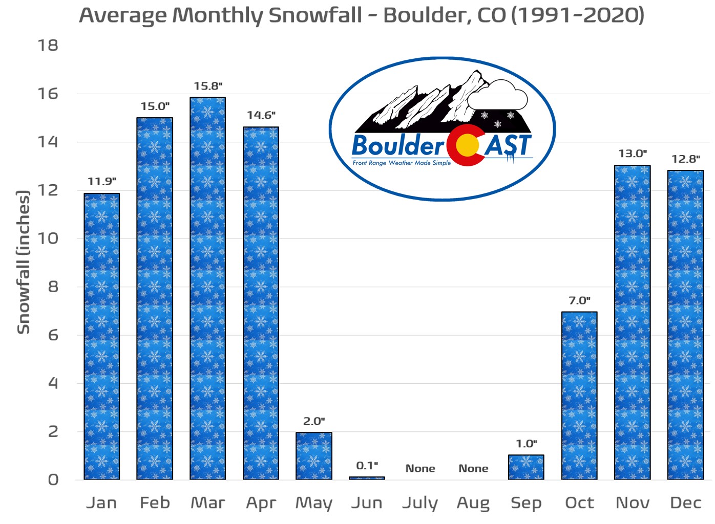
December Snowy Climatology: December is technically Boulder’s fifth snowiest month of the year with an average of 12.8″ (based on 1991-2022 data), so there is definitely a healthy amount of white stuff falling during the Holidays on average.
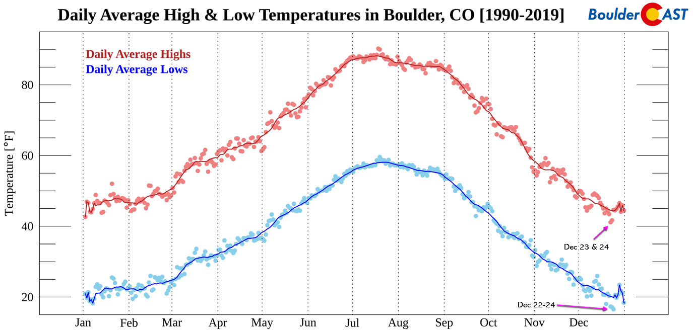
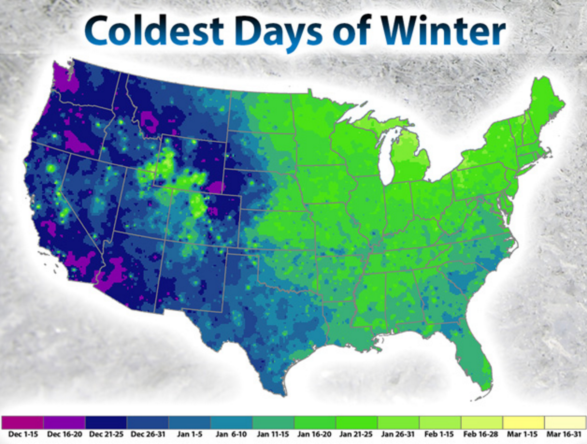
Coldest week of the year: How much snow is on the ground doesn’t just depend on newly falling snow. It also depends on old snow sticking around for longer once it has fallen. Thus, both soil and air temperature are also key factors influencing snow depth as both contribute to melting. As it turns out, the few days leading up to Christmas have in fact been the coldest in Boulder’s climatology. Both daily high and daily low temperatures show this same pattern.
The coldest days of the year occurring in December is something observed only over a small portion of the United States. Just about everywhere east of Boulder and in the Mountains will normally see their most frigid temperatures in January or early February. The map below is from the NCDC.
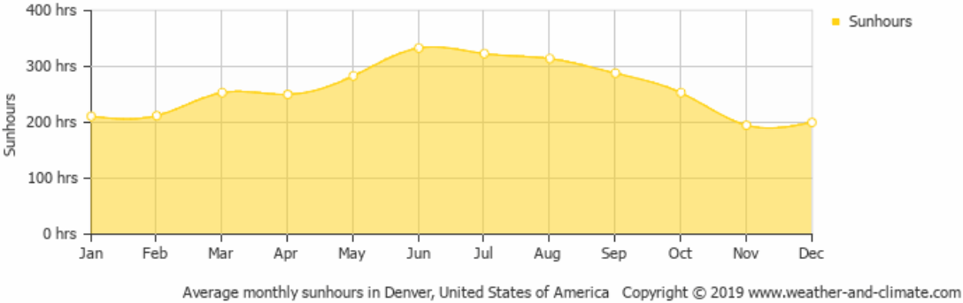
Winter Solstice timing: In addition to the week before Christmas being the coldest of the year in Boulder, it’s also when the Winter Solstice occurs annually. This is the time of the year with the lowest sun angle and shortest days, both of which are good for preventing drooping of any lingering snowmen. Denver’s climatology shows a marginal uptick in total sun hours in December relative to November due to slightly less clouds despite the shorter days, but it’s not much. December is still a very sun-lacking time of year.
Observer bias: Measuring patchy snow depth can be subjective. It’s possible some observers leaned more favorably toward reporting 1″ on this single day specifically , simply to make it an “official” White Christmas.
Bottom Line: Christmas Day in Boulder has one of the highest odds of having snow on the ground out of any day in the year, thanks to the fortunate overlap of recent winter storms, the persistent chill of climatological cold, and the limited strength of the December sun, which struggles to melt away what has already fallen. Fresh flakes floating down on the holiday are always the most magical, but more often it’s the lingering snowpack that nudges Boulder toward an “official” White Christmas designation. And if, over the decades, a few dedicated snow observers decided to give the city the benefit of the doubt, well—we can hardly fault them. After all, the spirit of the season is about generosity, joy, and celebration, and who wouldn’t want to bend the rules just a little to spread that extra measure of holiday cheer?
From all of us at BoulderCAST,
we wish you a Happy Holidays!

Help support our team of Front Range meteorologists by joining BoulderCAST Premium. Get the most accurate Boulder and Denver weather forecasts delivered to your inbox every single day plus much much more…

Share Colorado’s crazy weather! Share this post:


You must be logged in to post a comment.