
Unseasonably warm conditions will continue for the next few days before cooler and unsettled weather arrives later in the week. We’re also watching a potential winter storm but the track remains uncertain at this time.
Tranquil through Christmas Day, a little snow in the Mountains
We broke the bad news about the lack of a White Christmas this year in our forecast update on Saturday. Our thoughts on this matter have unfortunately not wavered in the last 48 hours. We’re still expecting dry and quiet weather across the Denver Metro area right through Christmas Day.
.
Early on this week, the weather story for us will be a strong ridge of high pressure anchored across the Great Plains.
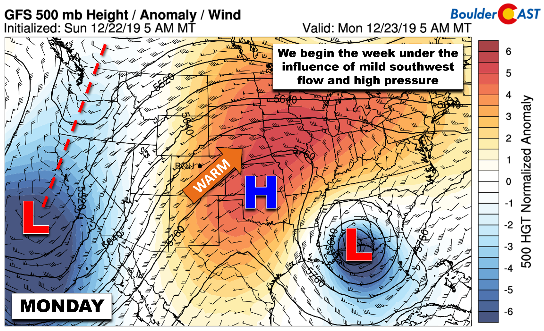
GFS 500mb height anomaly forecast for Monday
The pattern throughout the entire continental United States is rather stagnant and slow-moving right now. The ridge is in no hurry to head east and the trough entering the West Coast will be slow to progress into our area in the coming days. As you can see in the GOES-East water vapor animation below, the southwest flow ahead of the trough is pumping Pacific moisture northward into the Desert Southwest.
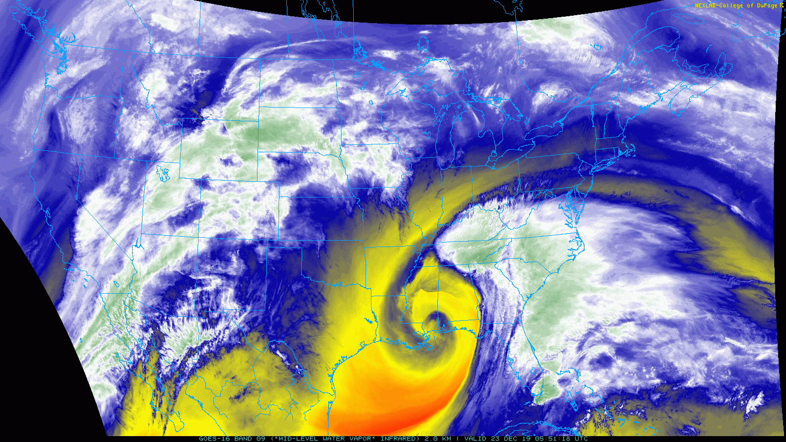
GOES-East water vapor animation from Monday morning
We’ll continue to remain in the region between the exiting ridge and approaching trough until Wednesday. During this time, temperatures will be generally above normal but dropping a few degrees each successive day. Expect highs in lower 60’s on Monday (with cloudy skies, shown below) and in the middle 50’s on Tuesday (with decreasing clouds).

HRRR cloud cover forecast for Monday mid-day
By Wednesday, the trough will start to influence our weather more so than the ridge. The outlook for this trough is bleak with it remaining rather disorganized in all the global models. Several weak disturbances are expected to eject eastward across Colorado, the first occurring Tuesday night into Wednesday morning. Most of the lift from this wave will stay across western portions of the state, with dry, sunny and mild conditions prevailing around Boulder and Denver for Christmas Day. For temperatures, we’re predicting highs in the mid 40’s. There is some indication for a second piece of energy passing quickly by Wednesday evening and night. With upslope flow at the low-levels in the Metro area, it’s possible this second wave could produce a few brief rain/snow showers before midnight on Christmas Day with little to no accumulation expected.
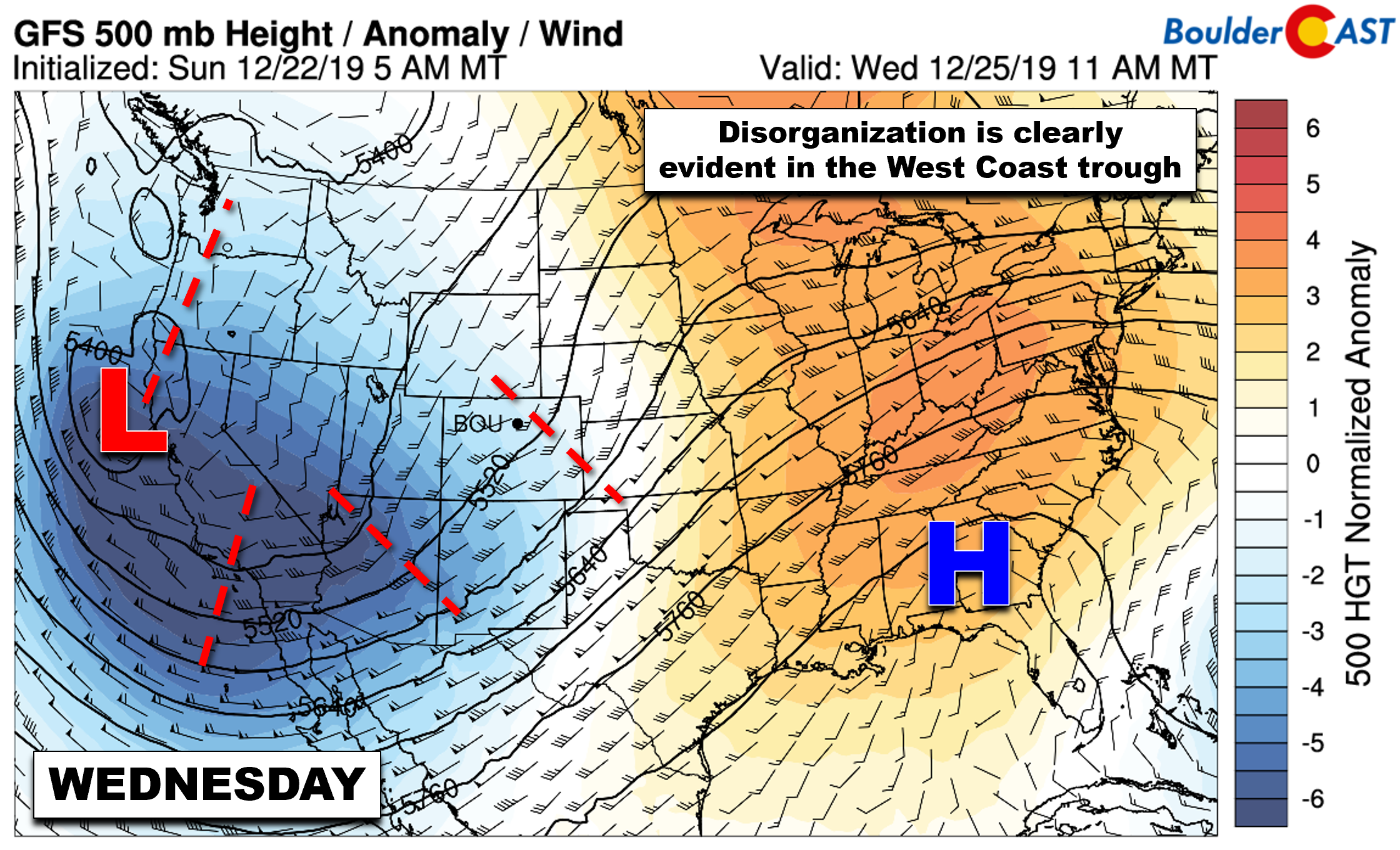
GFS 500mb height anomaly forecast for Wednesday
The lift across western Colorado will produce light to moderate snow accumulations in the Mountains…maybe (just maybe) enough for a little holiday powder for you to take advantage of. The general southwest flow certainly doesn’t favor the I-70 Mountains, but the San Juans should do alright.
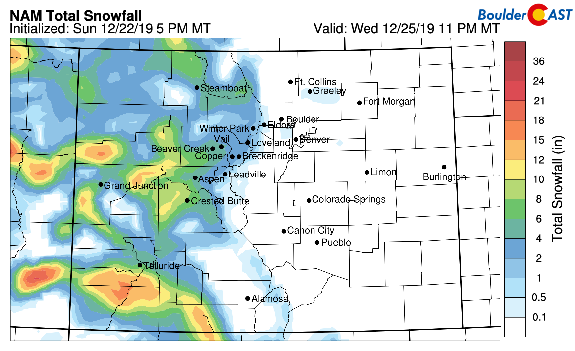
NAM model-derived total snowfall forecast through Wednesday evening
Late week winter storm uncertainty
The later we get into this week, the further eastward the disorganized trough will trudge. It’s not going to win any speed records, that’s for sure. It’s slow movement means that mildly unsettled weather will stick with us into the weekend. Models are in stark disagreement on exactly how this trough evolves, so at this point any prediction of our weather late in the week is an educated guess at best. Given the troughy set-up and embedded weak disturbances, a “safe” forecast points towards cooler weather (30’s to lower 40’s) with at least a slight chance of rain/snow each day beginning Thursday.
Despite differing large-scale model solutions for the trough, both the GFS and European models spawn a strong winter storm late Friday night into Saturday. The current track being advertised is too far south (see below).
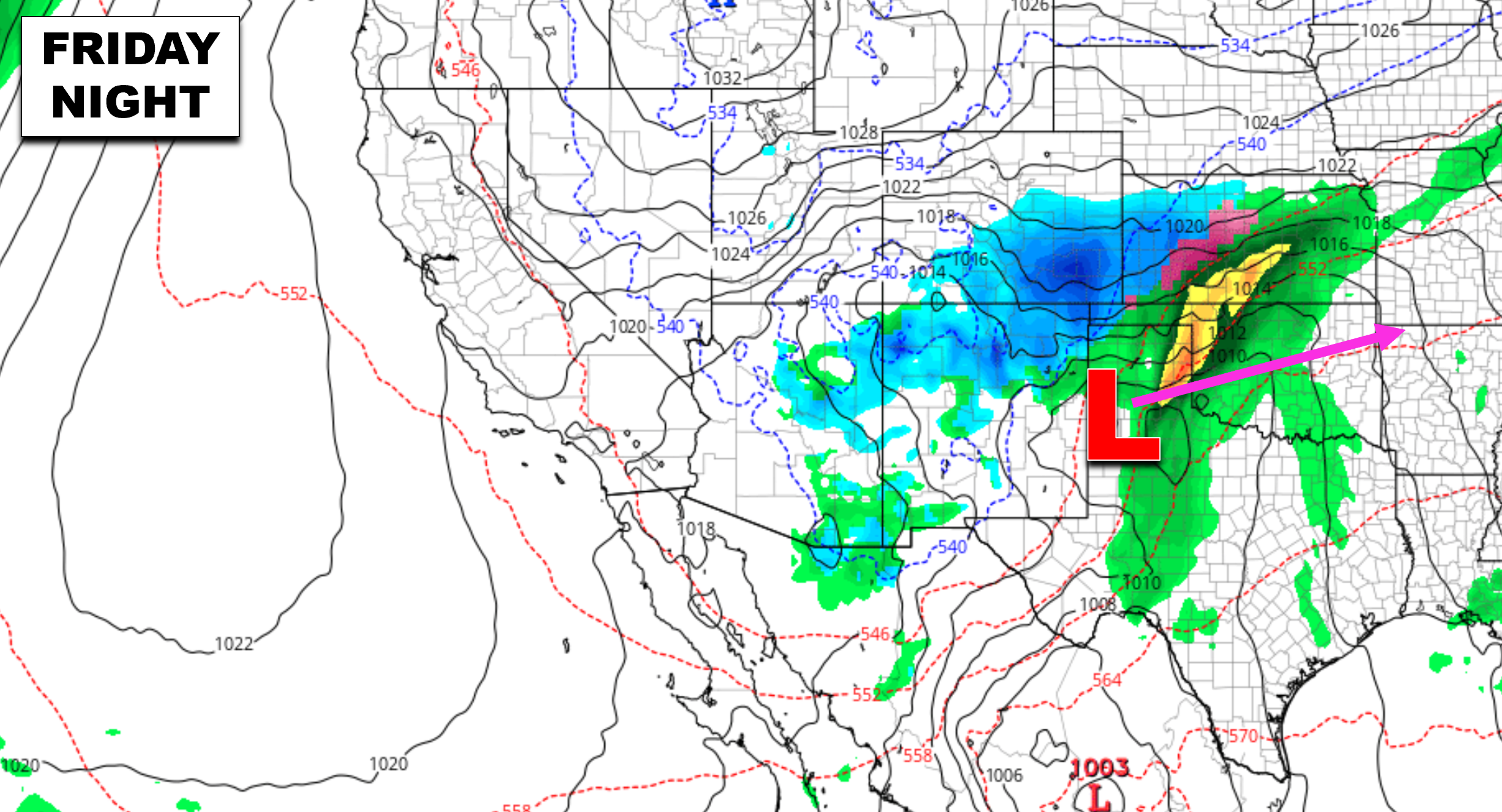
In this track scenario, the heaviest snow would fall across southeast Colorado near the surface low (see below). The Front Range may see periods of lighter snow from this system, however. The GFS and Euro are wavering back-and-forth with the track of this storm right now. Where ever it lands could see more than a foot of snow!
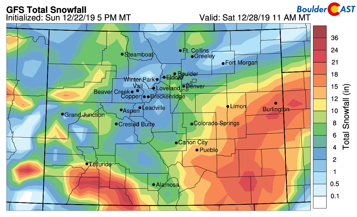
GFS model-derived snowfall forecast through Saturday
As we stated, the late-week forecast remains shrouded in uncertainty. We’ll definitely keep an eye on things given the possibility of a potent winter storm forming. Right now, the primary target does not appear to be the Front Range, but this can change. Stay tuned…
Subscribe to receive email notifications for BoulderCAST updates:
We respect your privacy. You can unsubscribe at any time.
From all of the BoulderCAST Team,
we wish you Happy Holidays!
.
Forecast Specifics:
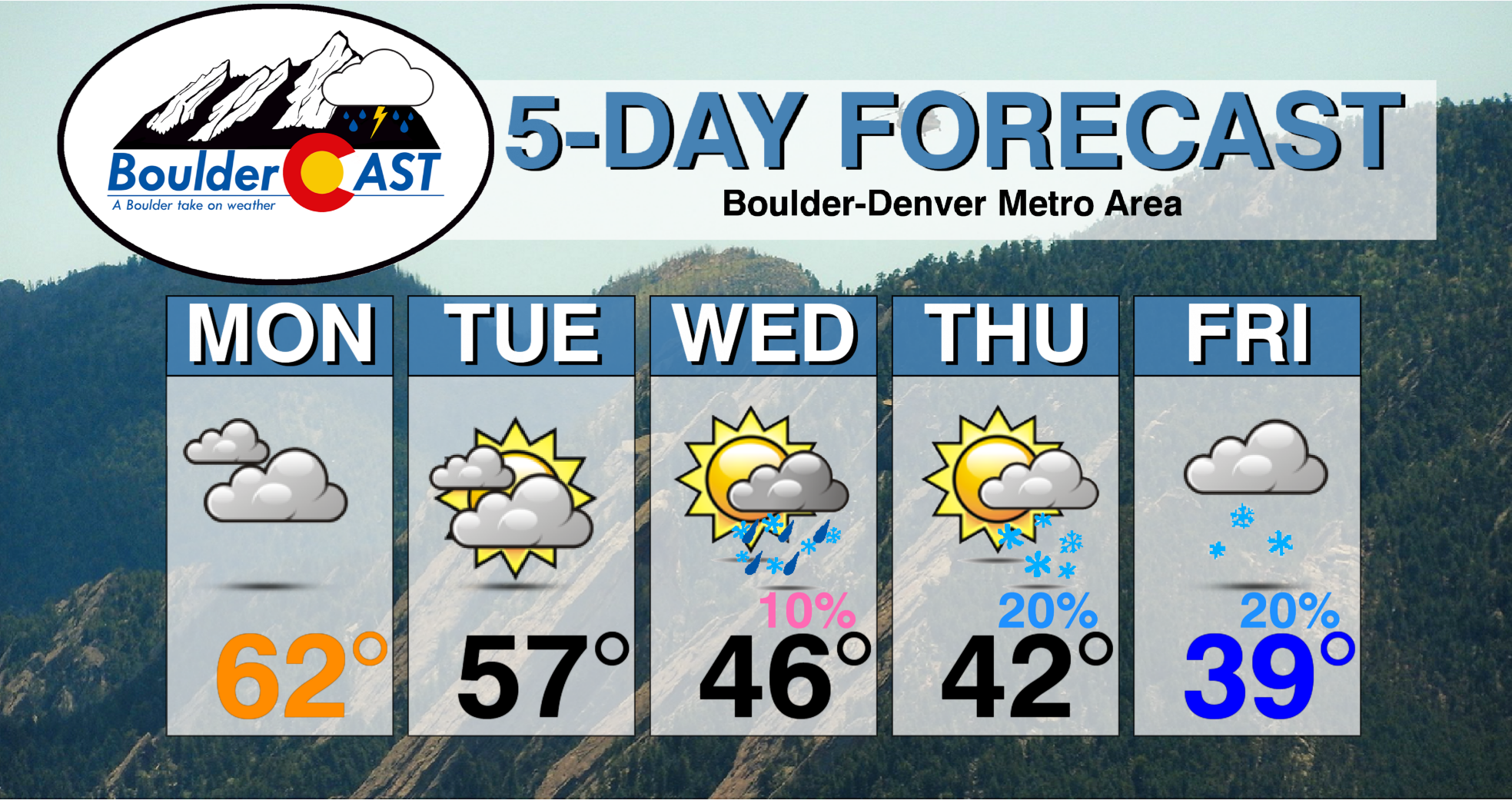
Monday: Unseasonably warm but overcast. Highs in the lower 60’s on the Plains and lower 50’s in the Foothills.
Tuesday: Mild and mostly cloudy with some clearing late in the day. Highs in the middle 50’s on the Plains and lower 40’s in the Foothills.
Wednesday: Partly sunny and pleasant with a very slight chance of late-day rain changing to snow showers. Little to no accumulation expected. Temperatures in the middle 40’s for the Plains and lower 30’s in the Foothills.
Thursday: Partly cloudy and cooler with a slight chance of light snow showers. Light accumulations possible. Temperatures in the lower 40’s on the Plains with upper 20’s in the Foothills.
Friday: Partly to mostly cloudy with a chance of snow late in the day. We’re tracking a potential winter storm which could clip the area as well bringing accumulation overnight into early Saturday. High temperatures in the upper 30’s on the Plains and upper 20’s for the Foothills.
High Country: Several waves of light snow will be possible in the Mountains this week as moist southwesterly flow impacts the state. The San Juans will do best with 6-14″ by Friday night. The northern Mountains may only see 2-6″ total this week as they are not favored by this flow pattern. Check our PowderCAST page for always-updated weather forecasts for all of Colorado ski resorts.

DISCLAIMER: This weekly outlook forecast is created Monday morning and covers the entire upcoming week. Accuracy will decrease as the week progresses as this post is NOT updated. To receive daily updated forecasts from our team, subscribe to BoulderCAST Premium.

.
Spread the word, share our forecast!


You must be logged in to post a comment.