Exactly three years to the day since a thousand Boulder County homes burned to the ground in the Marshall Fire, the Front Range is bracing for a similar yet tamer weather event on Monday, with high winds, elevated fire danger, and Mountain snow on the way. A quick-moving storm system will bring widespread gusts over 40 MPH to the area, creating conditions favorable for the spread of wildfires across most of drought-stricken northeast Colorado. While Monday is not expected to be as nearly bad as that fateful day three years ago, we urge you to remain vigilant to prevent any fire ignitions on Monday. We discuss the latest forecast, including how the developing conditions for Monday compare and contrast to those back in 2021.
At a Glance:
- Atmospheric Setup: A progressive storm system will pass to the north of the Front Range Sunday night into Monday, bringing strong winds to eastern Colorado, including the Boulder-Denver area.
- Wind Speeds: 35 to 55 MPH wind gusts are expected across much of the area, with the strongest gusts occurring Monday morning. Localized gusts over 65 MPH may occur in favored areas south of Boulder.
- Fire Danger: The high winds, combined with dry fuel conditions and mild temperatures, will create elevated fire danger. Red Flag Warnings are in effect for the entire Denver Metro area below 6000 feet elevation from 5 AM to 5 PM on Monday.
- Comparison to the 2021 Marshall Fire: While the conditions ahead are somewhat concerning, they are not expected to be nearly as severe as those during the Marshall Fire three years ago.
- Precautions: Residents are advised to be vigilant with fire, sparks, and flames to prevent potential large and rapidly spreading fires. There is also a possibility that power may be cut to some areas as a precaution.
Daily Forecast Updates
Get our daily forecast discussion every morning delivered to your inbox.
All Our Model Data
Access to all our Colorado-centric high-resolution weather model graphics. Seriously — every one!
Ski & Hiking Forecasts
6-day forecasts for all the Colorado ski resorts, plus more than 120 hiking trails, including every 14er.
Smoke Forecasts
Wildfire smoke concentration predictions up to 72 hours into the future.
Exclusive Content
Weekend outlooks every Thursday, bonus storm updates, historical data and much more!
No Advertisements
Enjoy ad-free viewing on the entire site.
If you want to help support the passionate work we do here at BoulderCAST and/or wish to receive a morning weather update from us every single day for the next year, consider subscribing to BoulderCAST Premium; our 2024 holiday sale is ongoing through the end of the year.
Will Monday be similar to the day of the Marshall Fire?
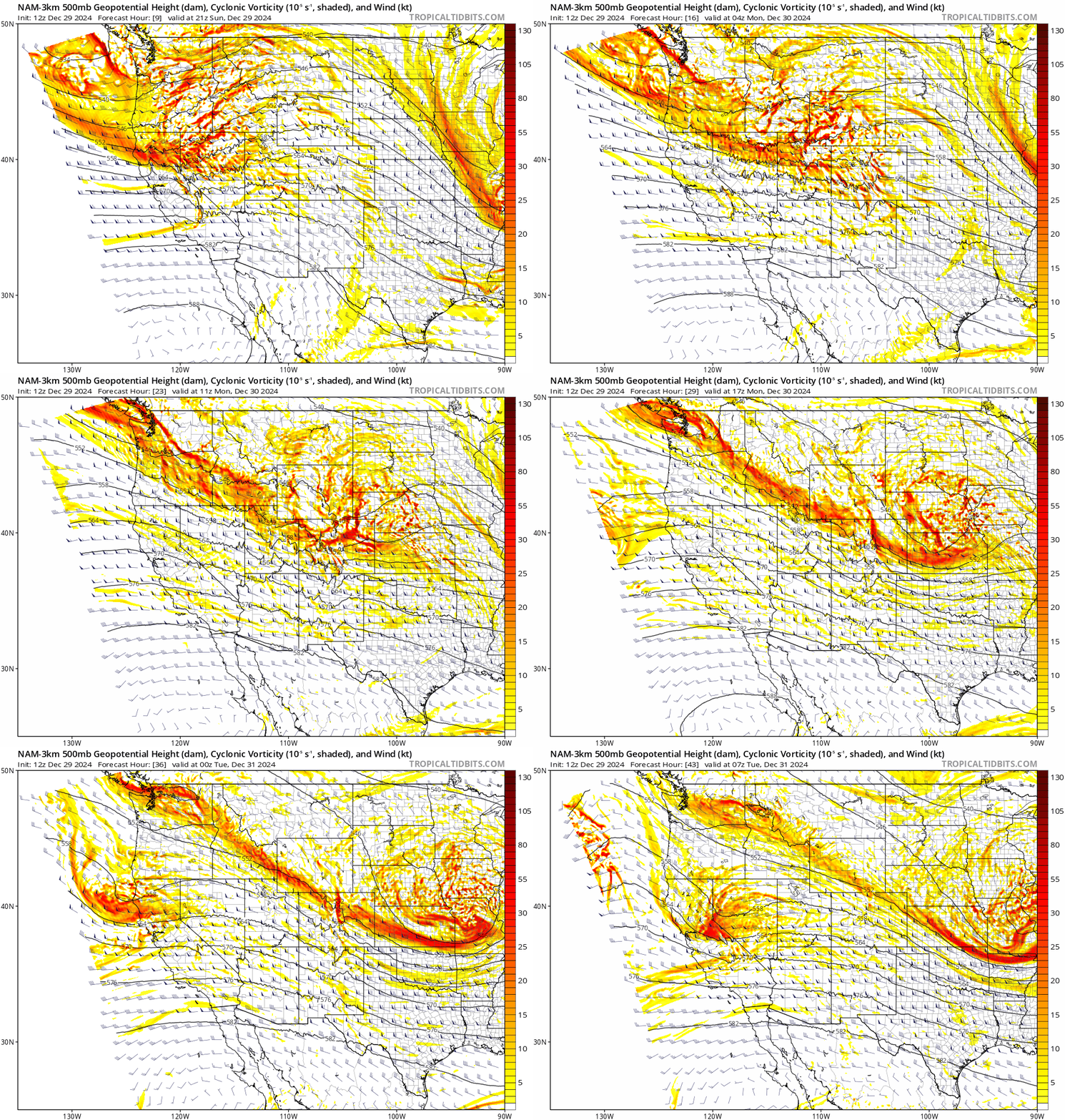
We’ll keep things (relatively) short and to the point in today’s update. In very typical fashion for this particular autumn (and now winter), a progressive storm system embedded in the northwest flow will quickly pass to the north of the Front Range Sunday night into Monday. As it does so, a potent jet streak and subsident flow will bring the risk of strong winds to all of eastern Colorado including the Boulder-Denver area, with continued snow in the Mountains. The mid-level wave can be seen in the 500mb height and vorticity forecast animation below. Notice how the bulk of the energy with this wave will be passing along the Colorado-Wyoming Border. As you might surmise, once again this setup won’t bring much precipitation east of the Mountains, and instead will be chock-full of wind!
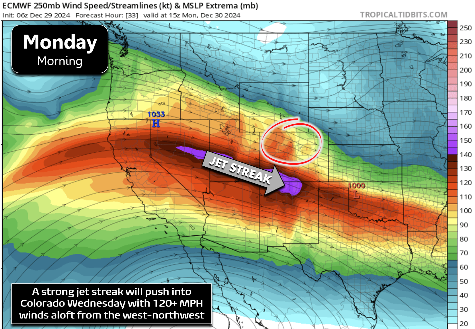
On the southern flank of this system, the polar jet stream will be blasting into Colorado Sunday night, with winds greater than 150 MPH at its core in southwest portions of the state. In our area, winds will maximize around 120 MPH during the day Monday at airplane cruising altitude. Winds near mountain-top level will be tamer at ~60 MPH from the due west — it’s these winds that be will be making their way down to ground-level and causing quite the ruckus!
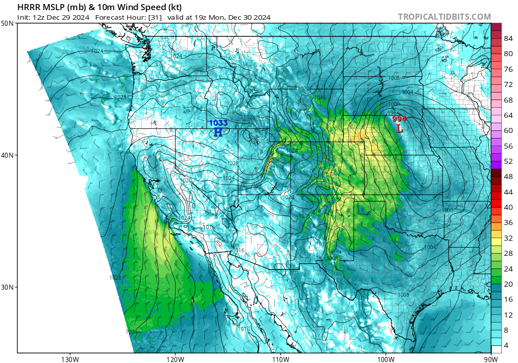
What we will see unfold on Monday is not a classic damaging downslope wind setup forced by a mountain wave. There’s no relevant stable layer of air near the top of the Continental Divide. Instead, these strong winds will be more readily forced by subsidence from the passing shortwave, an intensifying pressure gradient from lee cyclogenesis happening way out in Nebraska and Kansas (below), and daytime mixing.
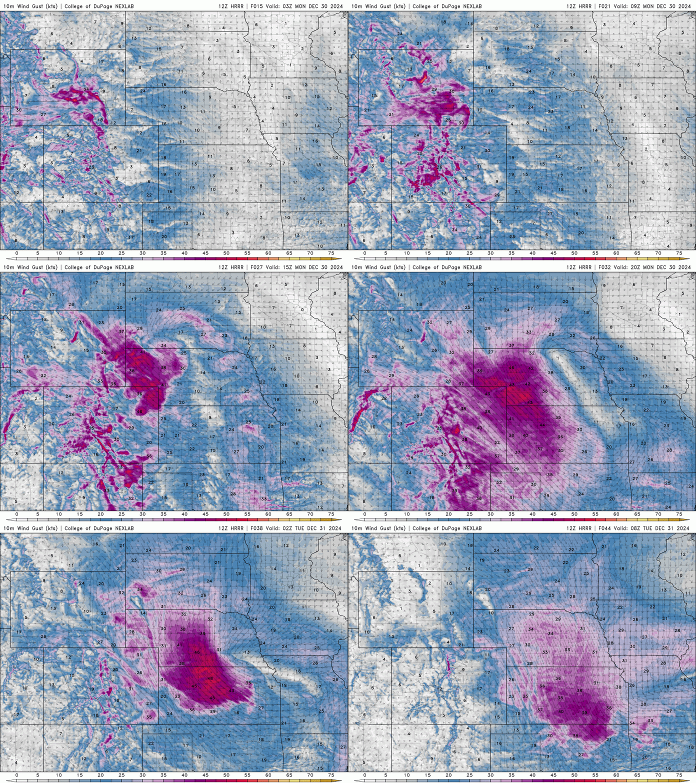
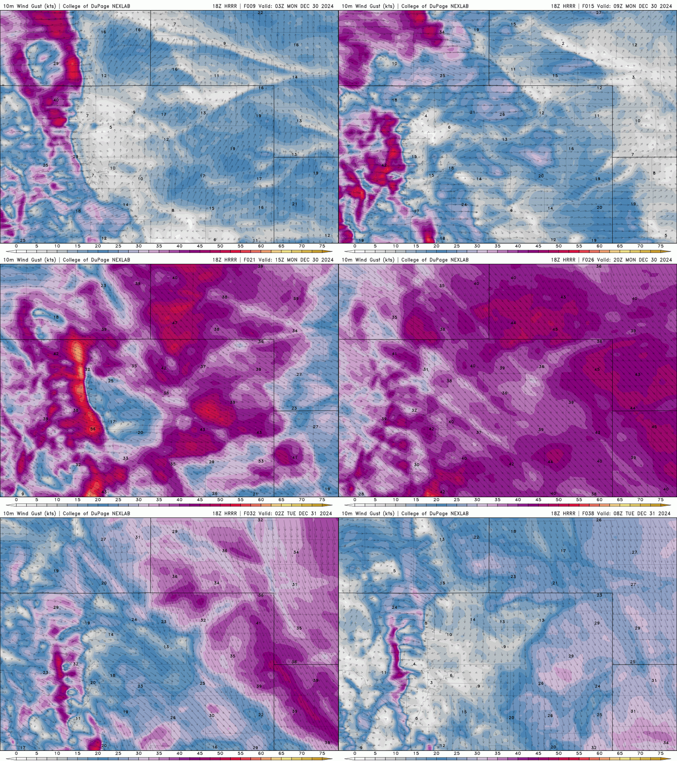
As the big low pressure blows up across Nebraska, a huge area of strong winds will whip up on the backside of the storm, including here in the Denver Metro. The result will be a lengthy period of moderate to strong winds for all of eastern Colorado, maximizing in our neck of the woods Monday morning. This is shown in the HRRR 10-meter wind forecast animation below:
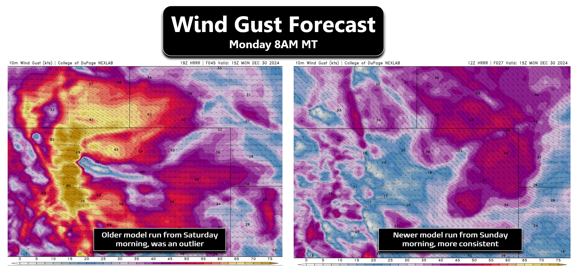
Over the last day or two, we have seen a few model runs cause worry about a “doomsday scenario” on Monday, with a couple outlier runs here and there looking somewhat similar to the fateful conditions on December 30, 2021 — the day of the Marshall Fire. For example, the left panel below shows a model forecast from Saturday for Monday morning’s wind gusts. Yikes — 75 to 95 MPH gusts for much of the area resulting from a weak mountain wave enhancing this already windy setup! At the time, this was a clear outlier as no other models were showing this intense of winds. Since then, this very same model has backed off considerably, with its latest runs Sunday morning thankfully coming in much lower and in much closer agreement with the rest of model guidance (below right panel).
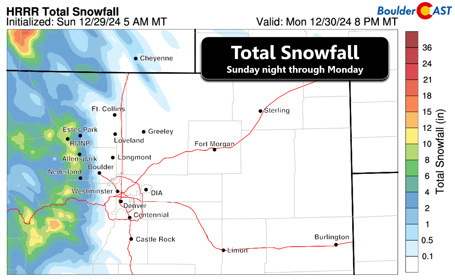
To play devil’s advocate for a moment, we note that the Front Range will be in the left exit region of the jet, a zone typically favorable for rising motion (and jet-forced snow bands), not sinking motion which aids in pushing the stronger winds aloft down to the ground. We’re also going to see a fair amount of Mountain snow accompany this passing storm (4 to 10 inches), perhaps boosted a tad by the aforementioned jet lift. Decent snow falling in the Mountains tends to prevent mountain waves from forming. Both of these aspects strongly suggest the fabled worst case scenario is off the table on Monday. Instead, we’re most likely going to endure a day of widespread (but not exceptionally) strong winds, with gusts in and near the Foothills not that much worse than what transpires across ALL of eastern Colorado. Yes, Monday will be a windy one in the Front Range, but it’s looking very unlikely to rival the magnitude of winds that fanned the flames of the Marshall Fire three years ago. That day we had widespread gusts over 70 MPH with peak gusts up to 115 MPH nearby the ignition point along Highway 93 south of Boulder.
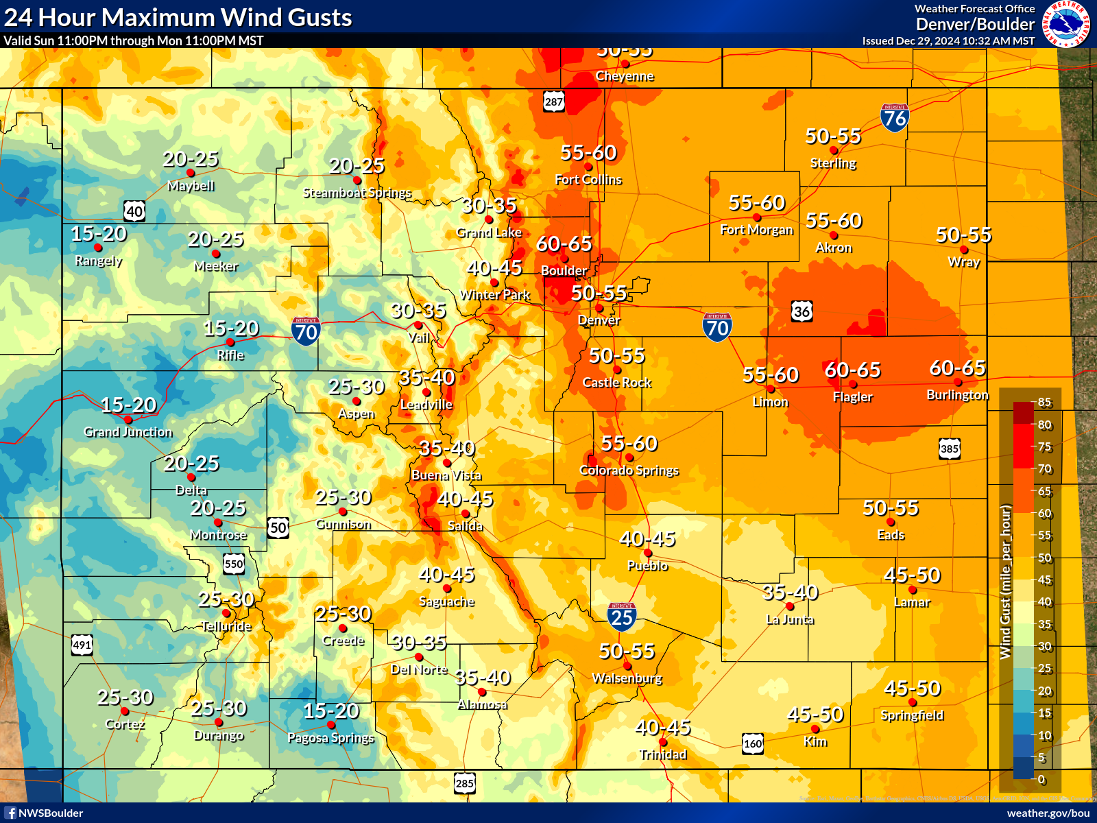
The latest maximum wind gust forecast blend from the weather service (below) aligns with our thinking for how Monday will unfold, though we still think their map is still a tad overdone. Overall, we’re expecting wind gusts to peak between 35 and 55 MPH for most of the area which could cause some minor damage, but probably not much. Across the eastern Plains, blowing dust will be a concern with possible travel impacts across Interstates 76 and 70 east of Denver.
Winds will be strongest Monday morning, approximately from 6AM to 2PM, but will remaining strong and pesky into Monday evening before waning Monday night. It’s conceivable that localized areas could see a couple brief gusts up to 70 MPH, but it’s hard to actually forecast that given this setup. This would be most likely to occur (but not likely on its own) in favored windy spots between Boulder and Golden.
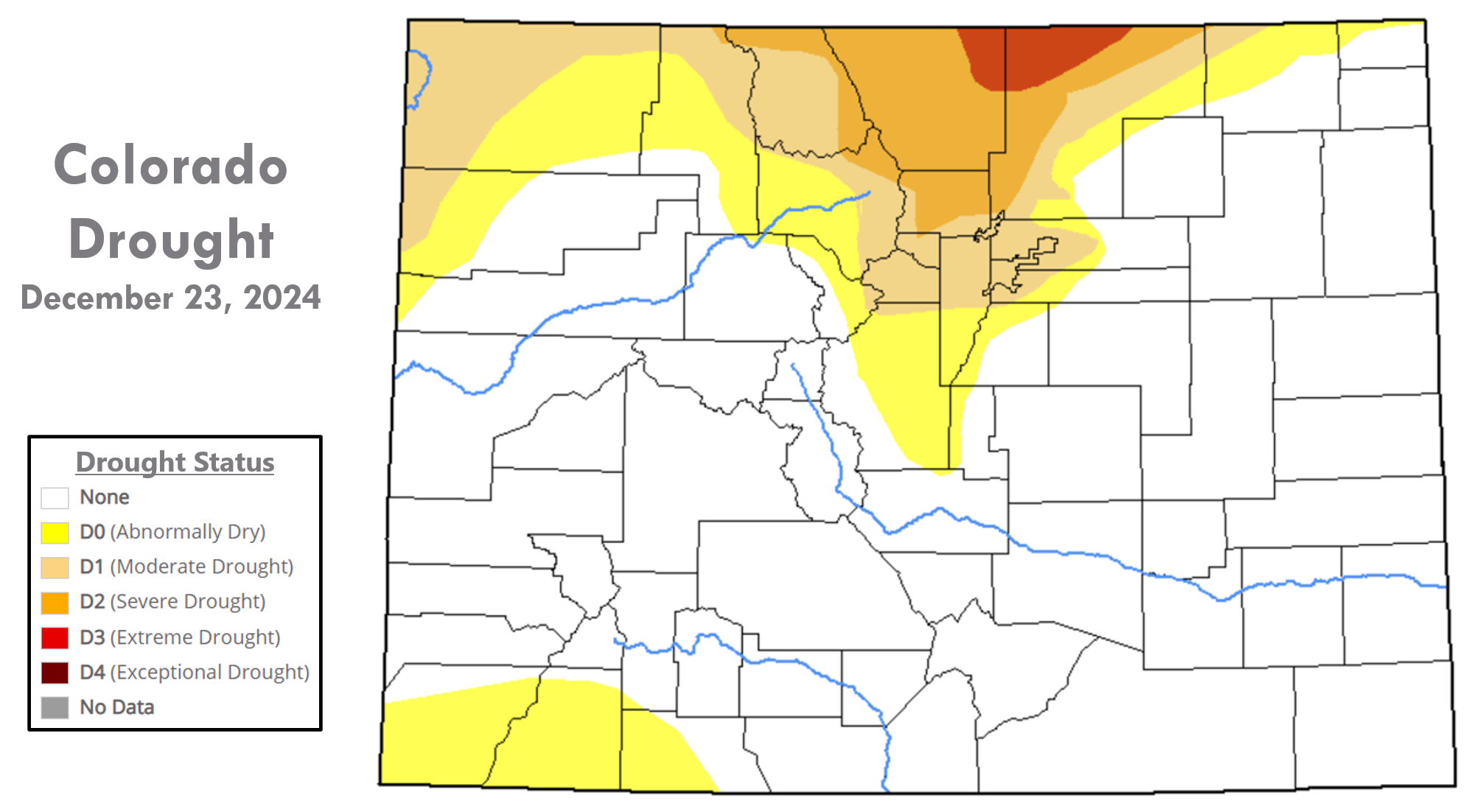
The far bigger concern on Monday, rather than the winds alone, will be the fire danger accompanying them. The entire northern Front Range is currently in a nasty drought, with Boulder, Larimer and Weld Counties in particularly rough shape. Similar to the conditions three years ago, it’s been a fairly dry autumn (but not record-breaking like it was then). Forest fuels are primed to burn, as are the grasses across the wildland-urban interface of the lower elevations. Keep in mind, though, that drought status doesn’t really matter all that much for the latter. As long as there isn’t snow on the ground, our prairie grasses are ready to burn within just a few days of the last precipitation event under sunny and mild conditions. As you are well aware, many a winter day meets those criteria here.
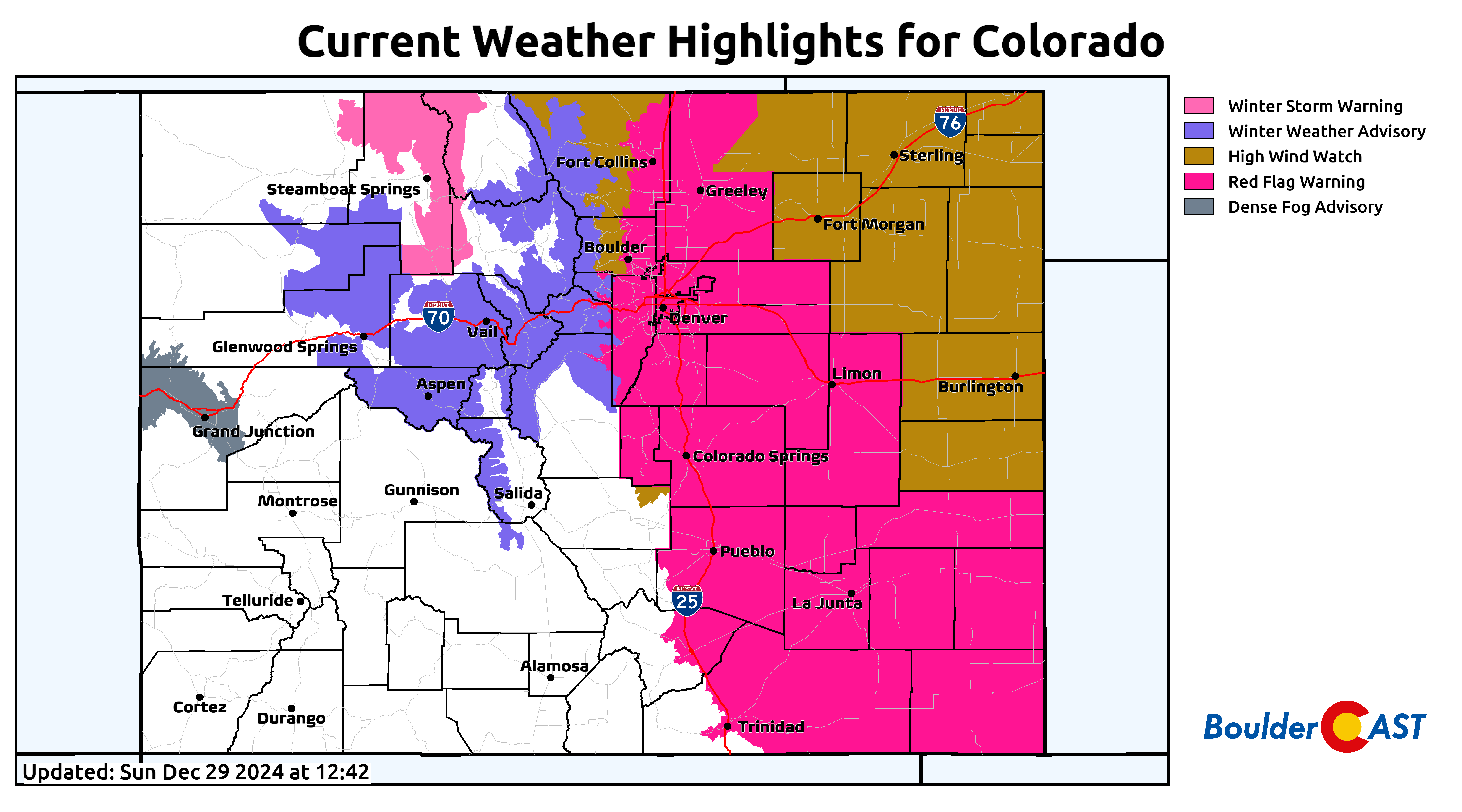
Red Flag Warnings are posted for the entire Denver Metro area below 6000 feet elevation for Monday from 5AM to 5PM. In fact, most of eastern Colorado is under a warning. As of writing, all of northeast Colorado is also under a High Wind Watch (hidden behind the Red Flag Warnings below). It’s possible the entire area is upgraded to a High Wind Warning very soon, but it’s not set in stone for the Metro area given the uncertainty in peak winds and unfavorable overall setup.
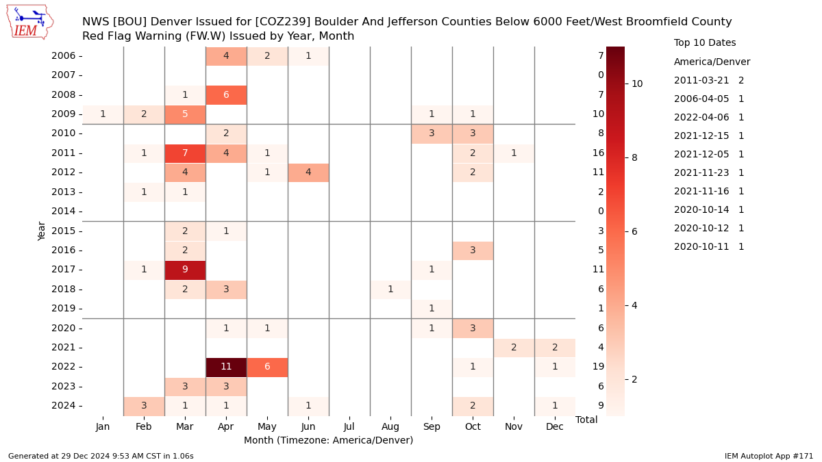
Up until 2021, Boulder had not seen a Red Flag Warning during the month of December for at least 15 years. We’ve now had Red Flag Warnings issued in three of the last four Decembers!
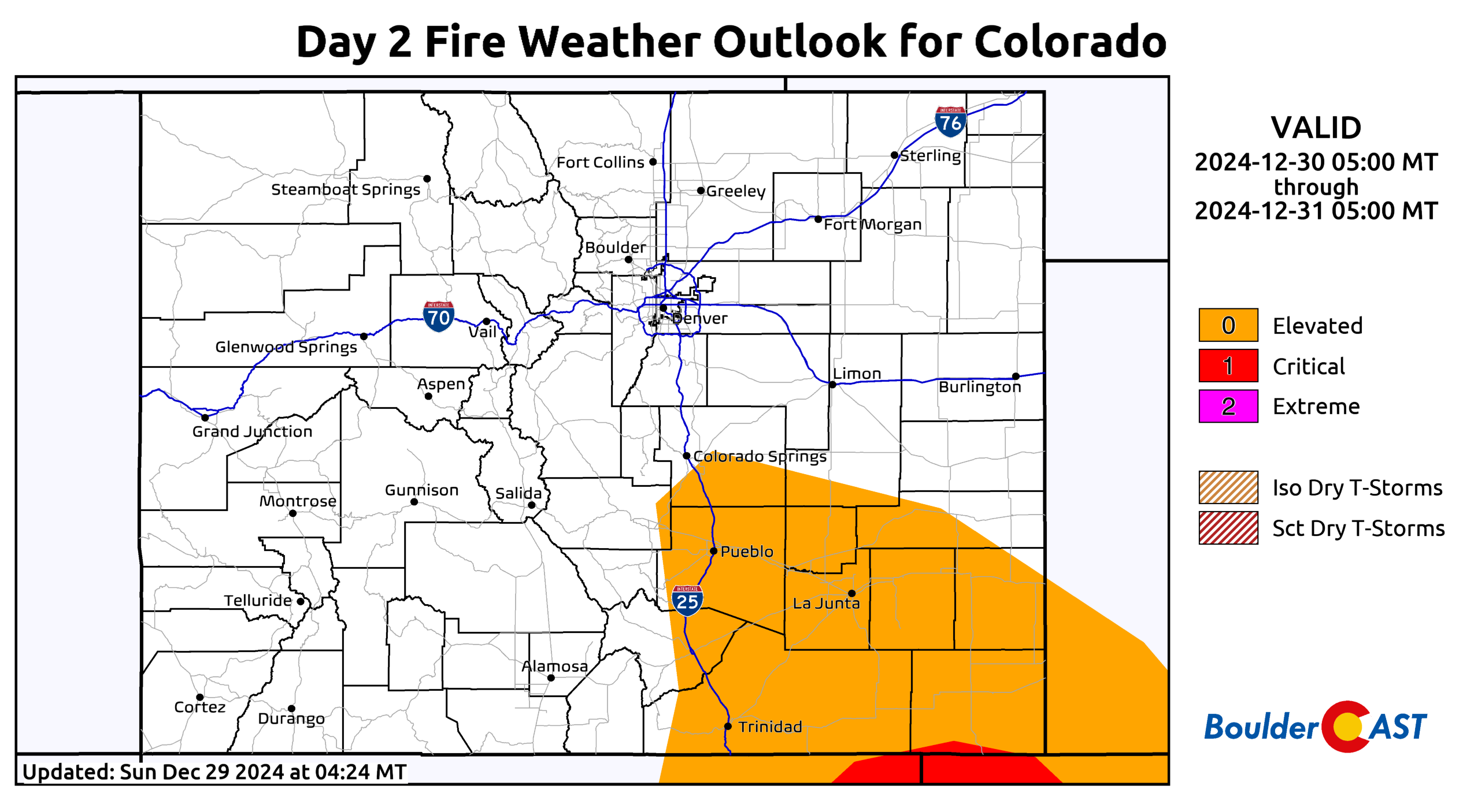
Outside of the wind aspect, atmospheric conditions won’t be that great for the spread of fire on Monday, with high temperatures only in the 40s and relative humidities bottoming out only around 25%. The Weather Prediction Center doesn’t even include our area in their lowest “Elevated” fire risk category (see below). How can that be you ask? Well, they purely focus on objective atmospheric conditions, without much (if any) consideration for fuel status or regional variations. The local weather office, which issues the Red Flag Warnings, has discretion to make more relevant decisions for their local area’s climatology and the situation at hand. Keep in mind there was NO Red Flag Warning issued for the day of the Marshall Fire ahead of time — a hard but important lesson was learned about what is theoretically possible in our “high desert” climate that day. That lesson is the reason we have Red Flag Warnings issued right now in the middle of winter with marginal atmospheric conditions…
Given the fuel status and that winds will certainly be gusting above 35 MPH for most of the area Monday morning into afternoon, we must all be vigilant with fire, sparks and flames to prevent potential rapidly spreading fires. Though we haven’t heard any word yet, it’s possible that Xcel Energy may cut power to some of the Boulder-Denver area to prevent downed power lines from igniting fires. That’s not our recommendation, nor our call of course. It also wouldn’t be a popular one with the community we reckon, especially given this won’t be an extreme event. Be smart and vigilant folks! Spread the word of the impending fire risk for Monday, but try not to oversell it as a repeat of 2021 — that it definitely is not…
Get BoulderCAST updates delivered to your inbox:
DISCLAIMER: This weekly outlook forecast is created Monday morning and covers the entire upcoming week. Accuracy will decrease as the week progresses as this post is NOT updated. To receive daily updated forecasts from our team, among many other perks, subscribe to BoulderCAST Premium.
Daily Forecast Updates
Get our daily forecast discussion every morning delivered to your inbox.
All Our Model Data
Access to all our Colorado-centric high-resolution weather model graphics. Seriously — every one!
Ski & Hiking Forecasts
6-day forecasts for all the Colorado ski resorts, plus more than 120 hiking trails, including every 14er.
Smoke Forecasts
Wildfire smoke concentration predictions up to 72 hours into the future.
Exclusive Content
Weekend outlooks every Thursday, bonus storm updates, historical data and much more!
No Advertisements
Enjoy ad-free viewing on the entire site.
Enjoy our content? Give it a share!





You must be logged in to post a comment.