This is an important forecast discussion involving a particularly dangerous situation that will unfold on Friday with extremely explosive fire conditions all day long. We review the atmospheric ingredients leading to such a dire situation and look at just how common days like this are in our climatology (spoiler: it’s very rare).
At a Glance:
- A strong storm system will race across the Rockies to end the week bringing a slew of impacts to the state
- Fire danger will literally be off the charts on Friday with “once in a decade” type of atmospheric conditions coming together
- Winds gusting 45 to 65 MPH during the day with relative humidities below 10%
- Any spark could spawn a rapidly growing wildfire or grassfire — stay aware on Friday of nearby conditions and spread the word of warning!
We discuss Boulder and Denver weather every single day on BoulderCAST Premium. Sign up today to get access to our daily forecast discussions every morning, complete six-day skiing and hiking forecasts powered by machine learning, access to all our Front Range specific weather models, additional storm updates and much more!

L
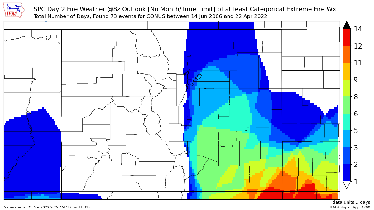
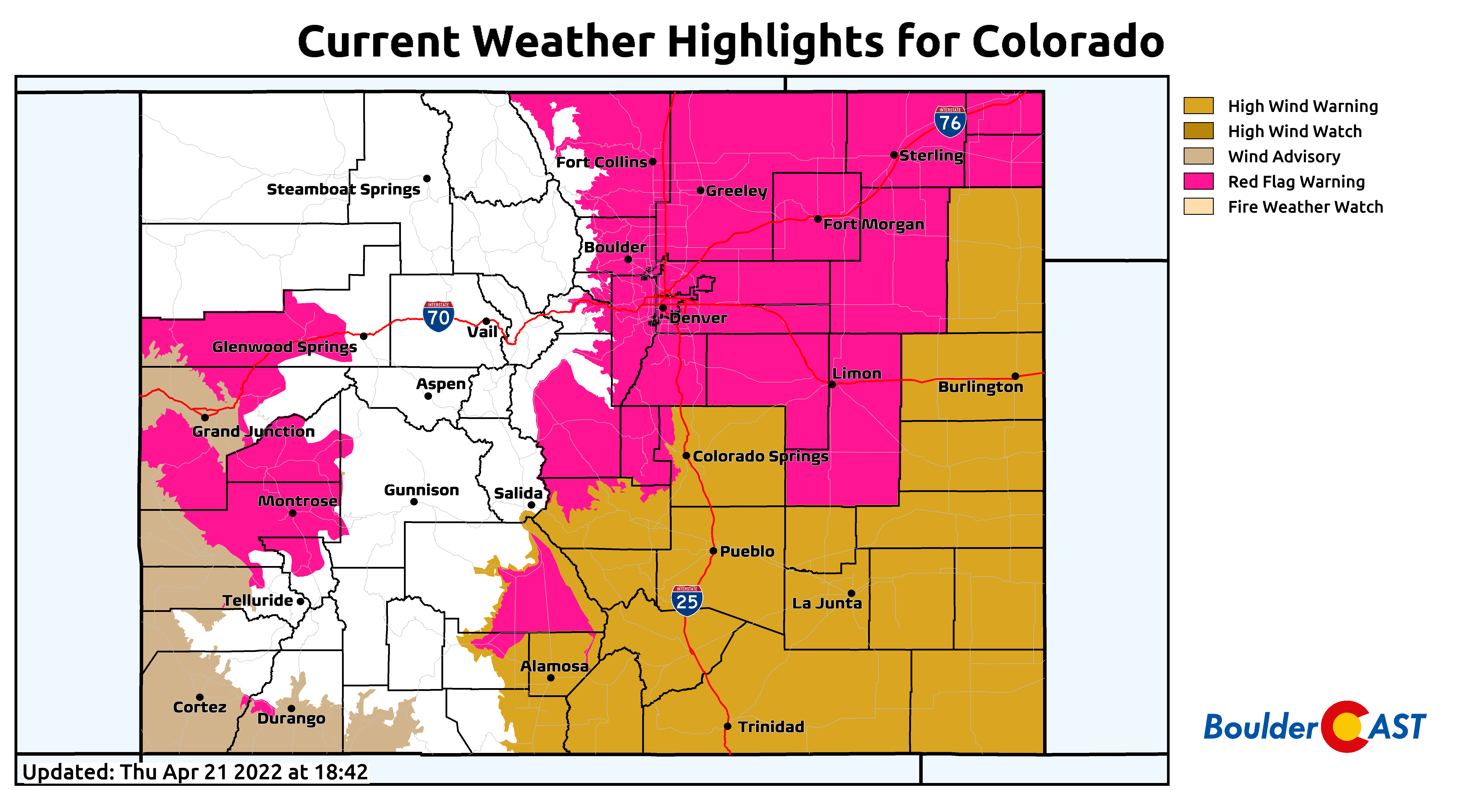
et this forecast update serve as an dire plea from our team to you to be very aware of the weather conditions to end the week. We can’t stress this enough — a particularly dangerous situation is about to unfold across the state of Colorado and surrounding areas on Friday as the atmosphere will align just right to produce extremely volatile fire conditions. We alerted you to the potential for fire weather to return again in our weekly outlook Monday. At the time, we could not have possibly foretold how bad this situation would become. The National Weather Service has been figuratively screaming as loud as they can the last few days to raise awareness. Lesser known to the general public, the Storm Prediction Center has gone ahead and issued a rare “Extreme” fire outlook over a large swath of eastern Colorado for Friday. Most of the Denver area is included in this, but Boulder is just outside the bounds.

Inclusion in this category by the SPC is very rare for our area. In fact, downtown Denver has only been “painted magenta” once or twice in the last 16 years! Boulder has never been so.
What makes Friday so EXTREME and off the charts in terms of fire risk? It really is the perfect storm of several key ingredients all coming together. Let’s take a look…
Ingredient #1: Dry & bountiful fuels
2022 began with the absolute snowiest start to a calendar year on record spurring notable drought improvement across much of north-central Colorado. It was only until this week that the United States Drought Monitor expanded their Moderate Drought categorization back into the Denver Metro area. This comes after a month straight of mostly dry weather in the Front Range. Despite the slight green-up of the vegetation out there, only 0.35″ of rain/snow has fallen in Boulder over the last month. This is way below normal — we should be closer to 2.9″ during what is typically our second wettest and second snowiest month of the year. You don’t even want to know the miniscule precipitation values for Denver…
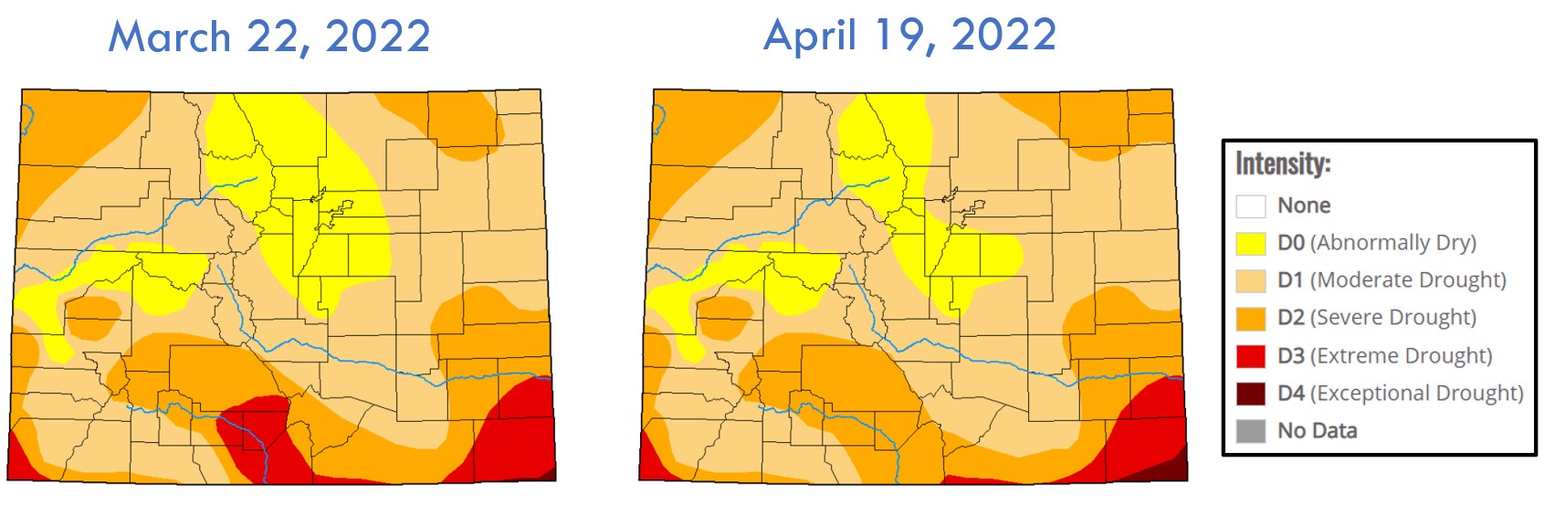
Additionally, the plentiful grasses that sprouted up during the wet spring of 2021 are still blanketing the ground as fuel. The Marshall Fire in December took advantage of them, and so too have the plethora of “small” grassfires we’ve seen over the last several weeks. The open space is literally a tinderbox right now, and we in Boulder County have more of it interspersed into our neighborhoods than most places. The stage is set…
Ingredient #2a: Strong southwest winds gusting up to 65 MPH during the day
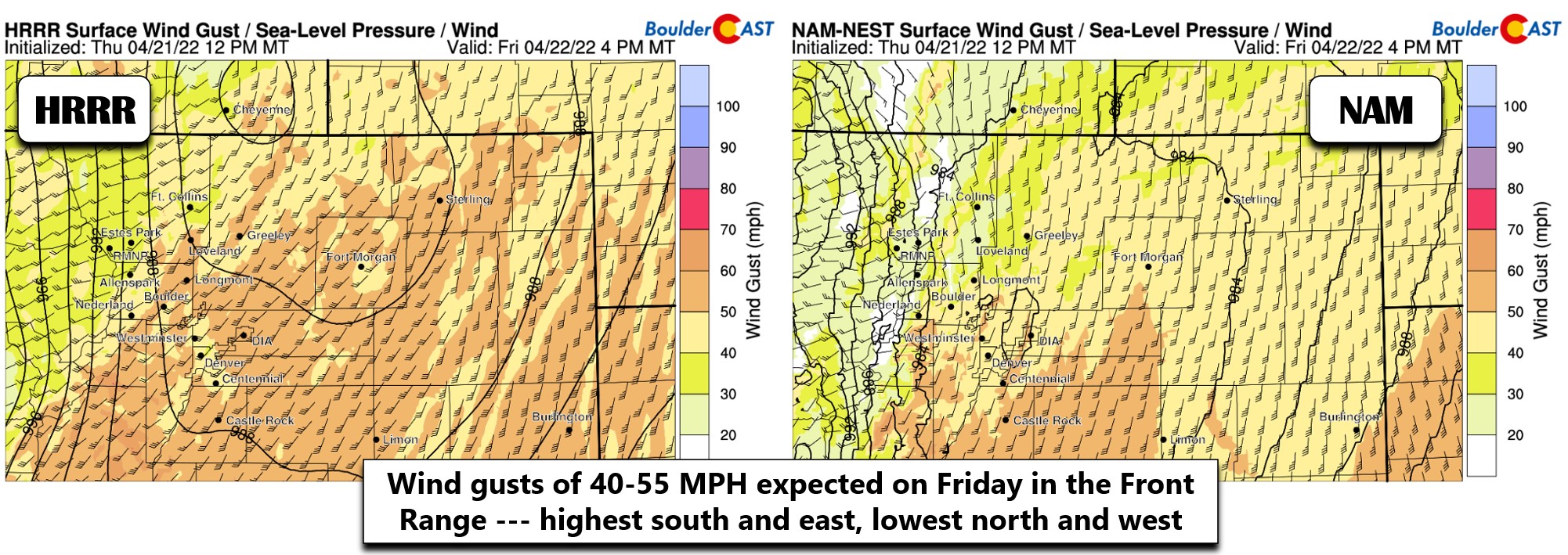
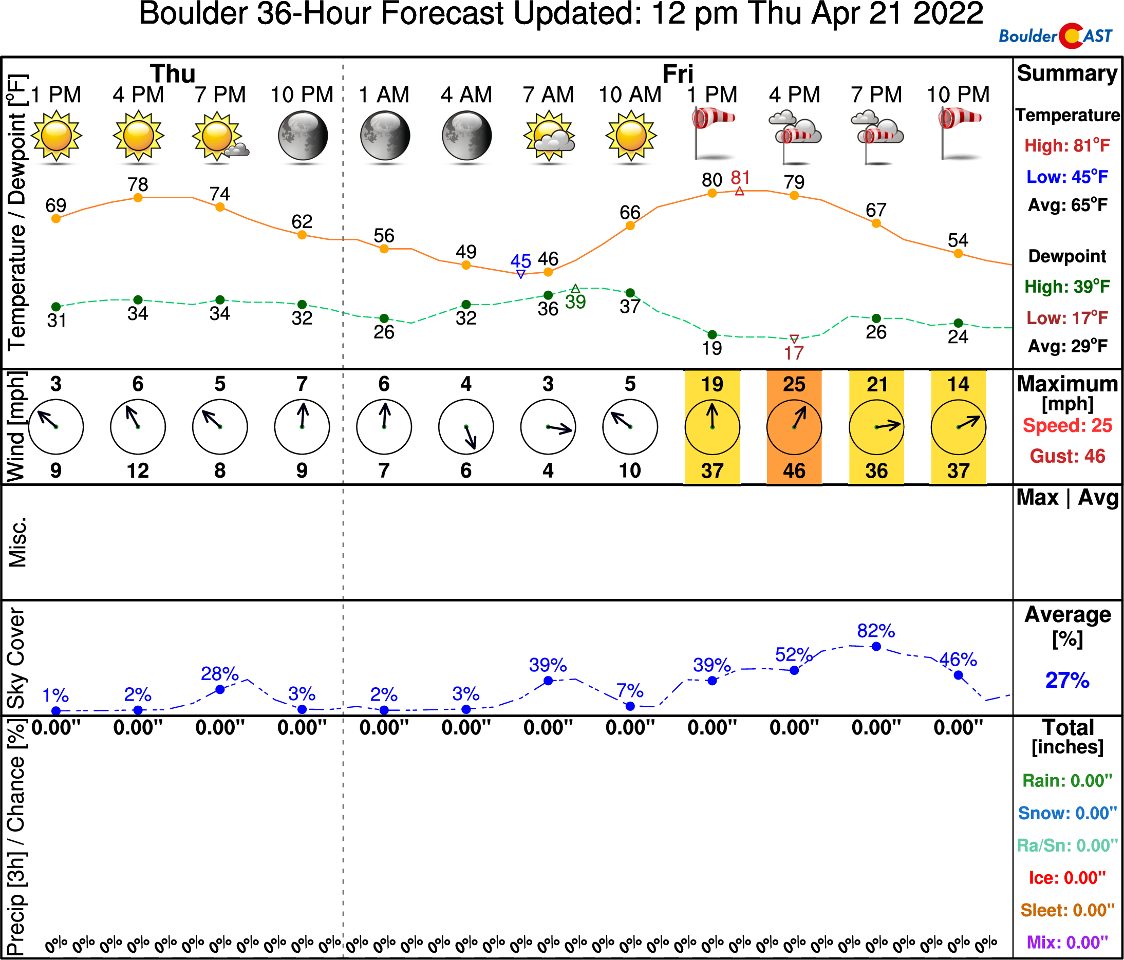
A potent storm system is projected to move across the central and northern Rockies on Friday. While the track of the main low pressure ended up being too far north to bring much (if any) precipitation to our area, it will certainly pack a windy punch. Wrapping around the base of the trough is a potent jet streak which will nose into Colorado during the day Friday. Strong winds associated with this jet will mix down to the surface from around midday into the evening hours.

Models have been inching up their wind speed forecasts over the last few runs. We’re now expecting gusts of 45+ MPH to encompass most of the area, with top end surges around 65 MPH possible. The worst of the winds will be south and southeast of Denver from late morning until about sunset. High Wind Warnings are also issued for Denver and areas east and southeast. As of writing, Boulder is currently excluded from the this highlight. Boulder tends to be somewhat sheltered from these types of wind events coming from the south and southwest, so we may actually make out better than the rest of the Denver Metro area.
We mentioned this in our post earlier today, but unlike most high wind events, the winds on Friday will be coming from the south and southwest. Any fires that form will spread to the north and northeast. Just something to be aware of if you do see smoke — know your directions!
Ingredient #2b: Even stronger west-northwest winds in the Foothills lingering into Saturday
Furthermore, a cold front will race across the Boulder-Denver area during the evening hours on Friday — we have this timed to arrive just before sunset. This will shift winds to be out of the west-northwest, with an intensity that could actually increase winds in some locations as a mountain wave gears up. Winds will rise in the Foothills and possibly the adjacent Plains during the late evening hours and grow even stronger heading into early Saturday. 70+ MPH gusts are definitely possible in the Foothills late Friday night into Saturday. Lesser though still very blustery winds will be possible across the lower elevations much of the day and evening Saturday as well. Though temperatures will be cooler and humidities higher, fire danger will be elevated and existing fires would still spread rapidly.

Ingredient #3: Bone-dry air
Your skin may have been letting you know it’s been dry the last few weeks, but you haven’t seen anything yet. Relative humidities are forecast to drop to some of the lowest values yet in 2022 during the day on Friday coincident with the high winds. Red Flag Warnings only require humidity values to be below 15%. High-resolution models are showing almost the entirety of eastern Colorado’s Plains dropping below 10% humidity on Friday afternoon! This level of dry is about as close as the vegetation will ever come to spontaneous combustion!

Ingredient #4: Near-record warmth in the 80s
The very same southwest flow composing the strong winds will be pumping warm, bone-dry air in from the Desert Southwest on Friday, as it has been doing so many days the last few weeks. High temperatures on Friday will climb into the lower to middle 80s, very close to daily record highs in most cities. Some parts of southeast Colorado will reach the 90s. Boulder’s record value for April 22nd is 84°F set back in 1989. We’ll likely be right in that ballpark Friday afternoon. This is some 20 degrees above normal for late April. Warmer temperatures allow the thinner grasses, the so-called one-hour fuels, to dry out more quickly after the overnight bump in humidity.

Surface temperature anomalies on Friday afternoon in °C as forecast by the GFS ensembles
Result: “Once in a decade” extreme fire danger on Friday!
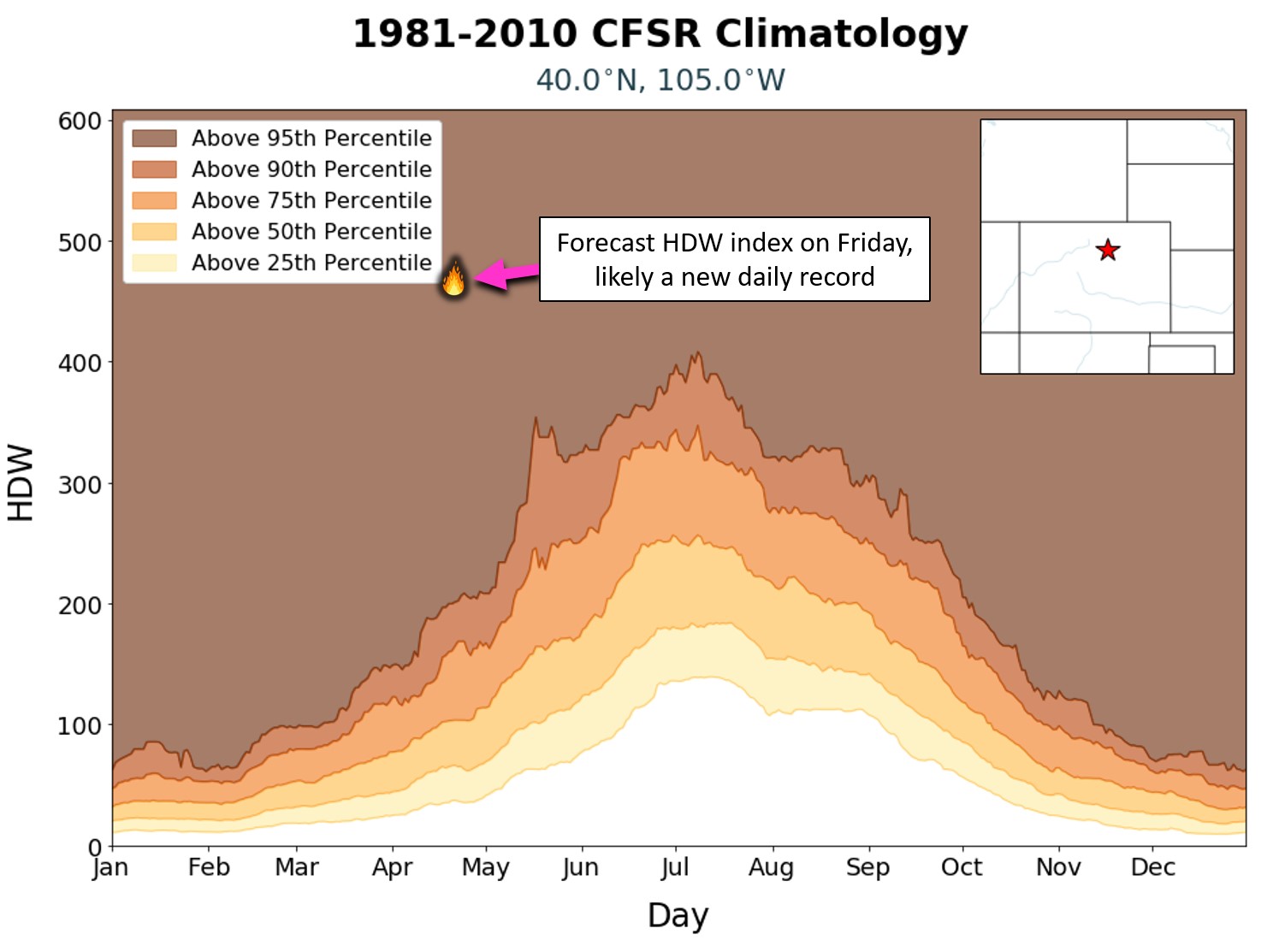
Considering all the of the ingredients coming together, Friday is as dangerous as it gets for fire growth across the Front Range. A day this extreme only occurs about once every 10 to 15 years in our area. The Hot-Dry-Windy (HDW) index is a parameter used to gauge how conductive atmospheric conditions are for rapid wildfire growth. Would you believe that the HDW is nearly off the charts for Friday? The GFS ensembles are predicting a value for the HDW around 450 (fire icon below). This is likely a new record high for the month of April in Boulder — at least from the graph below we know it is way beyond the 95th percentile of the last 30 Aprils.
Even worse, there’s really no reprieve from the wind beyond Friday either. Unlike the Marshall Fire which had relaxing winds and a snowstorm waiting in the wings, we don’t have much to fall back on with this event. If a fire does ignite, especially early in the day Friday, there will be many many hours of strong winds ahead to spread it almost uncontrollably. This critical warning message is definitely getting out there, but please do your part and continue to spread the word. There are still plenty of people that are not aware of how critical Friday’s fire risk really is! It only takes single bad decision by one person for things to go south very fast on days like this. Considering that there are roughly four million Colorado residents currently under the Red Flag Warning for Friday, odds are high there will be a few bad outcomes somewhere along the line.
Fingers crossed, though. Stay vigilant, safe and fire aware!
P.S. No time to discuss these aspects of the storm right now, but watch out also for blowing dust across the eastern Plains along I-70 and I-76 on Friday, plus a few inches of snow in the Mountains, and isolated supercell thunderstorms along the Kansas Border area.
Get BoulderCAST updates delivered to your inbox:
Help support our team of Front Range weather bloggers by joining BoulderCAST Premium. We talk Boulder and Denver weather every single day. Sign up now to get access to our daily forecast discussions each morning, complete six-day skiing and hiking forecasts powered by machine learning, first-class access to all our Colorado-centric high-resolution weather graphics, bonus storm updates and much more! Or not, we just appreciate your readership!
Enjoy our content? Give it a share!


You must be logged in to post a comment.