
Our scorching hot, two-week-long heatwave will finally come to an end later this week, but not before we endure a few more days. A cold front is slated to arrive into the Denver area late Wednesday finally knocking us out of the 90s. This front will also come with an enhanced chance of rainfall, though monsoon moisture is still largely lacking. Despite daily chances for rain this week, our existing fires will continue to smolder and the risk of new fire ignitions remains uncomfortably high.
This week’s highlights include:
- Wildfire Update: A series of wildfires ignited last week in the Front Range. Despite burning more than 12,000 acres of forest and dozens of homes, the fires are mostly under control now.
- Heatwave Continues: Three more very hot days are expected before cooler weather arrives. Highs will be well into the 90s through Wednesday.
- Smoke Concentrations Remain Low: Smoke from nearby and distant fires will be fairly low this week, though we could see an uptick late in the week.
- Cold Front Inbound: A cold front Wednesday evening will usher in cooler and stormier conditions late-week, finally cracking the two-week-long heatwave we’ve endured.
- Rainy Thursday? The best chance of rain will unfold on Thursday with numerous showers and storms expected. As always, there are some wrenches to look out for.
- Tropics Turning More Active: Hurricane Debby is making landfall Monday morning in Florida, while the Eastern Pacific could have four active named storms soon.
DISCLAIMER: This weekly outlook forecast is created Monday morning and covers the entire upcoming week. Accuracy will decrease as the week progresses as this post is NOT updated. To receive daily updated forecasts from our team, among many other perks, subscribe to BoulderCAST Premium.

Go Premium, get all the perks.
Daily Forecast Updates
Get our daily forecast discussion every morning delivered to your inbox.
All Our Model Data
Access to all our Colorado-centric high-resolution weather model graphics. Seriously — every one!
Ski & Hiking Forecasts
6-day forecasts for all the Colorado ski resorts, plus more than 120 hiking trails, including every 14er.
Smoke Forecasts
Wildfire smoke concentration predictions up to 72 hours into the future.
Exclusive Content
Weekend outlooks every Thursday, bonus storm updates, historical data and much more!
No Advertisements
Enjoy ad-free viewing on the entire site.
Fire updates
In last week’s outlook, and really all summer long, we warned how perilous the situation was across the Front Range following three months of extremely dry conditions. It was more a matter of when the fire season would take off here, rather than if. However, no one could have foreseen how rapidly things would turn ugly last week with as many as ten fires igniting in just a few days’ time — so rapidly that many local conspiracy theorists proclaimed that a wildland arsonist was on the loose! Most of the bigger fires started early last week when winds were unfortunately more favorable for growth. As the week went on, winds relaxed and allowed firefighters on the ground and in the air to gain the upper hand on most of the fires.
⚠️ Winds will be gusting 20-30 MPH in these fires through sunset from the west. It's going to be a rough next several hours of rapid growth. Do not ignore evacuation orders, especially if you are located east of these fires! #COWX #StoneCanyonFire #AlexanderMountainFire #COfire https://t.co/xYu4lQFoYV
— BoulderCAST Weather 🏔️❄️ (@BoulderCAST) July 30, 2024
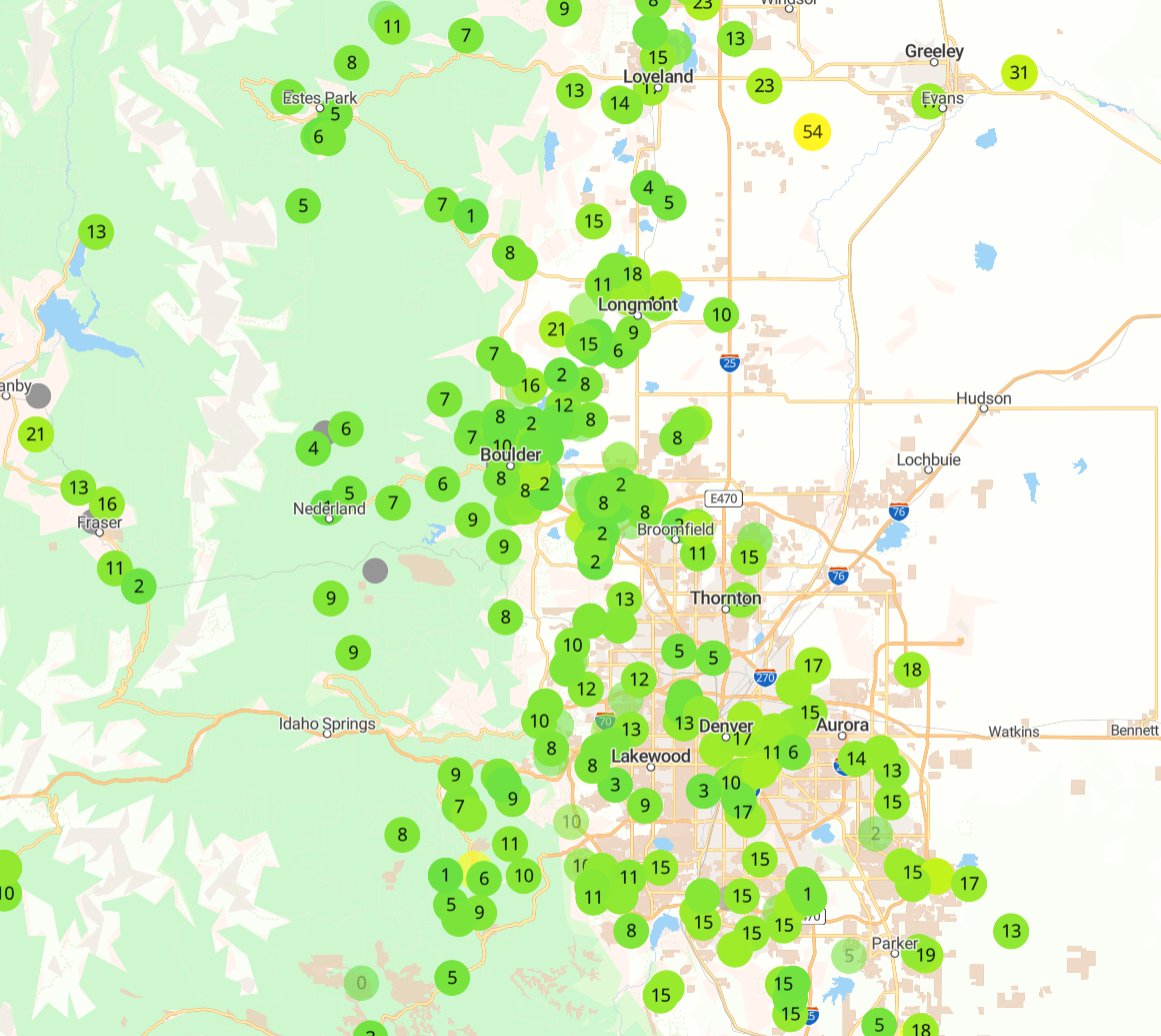
As of Monday morning, here are some updates on the most significant fires to spawn in the Front Range last week, totally nearly 12,000 acres of forest burned, 25+ structures lost and sadly one death:
- Alexander Fire west of Loveland: 9668 acres burned, 54% contained, 24+ structures lost
- Stone Canyon Fire north of Lyons: 1557 acres burned, 100% contained, multiple structures lost, 1 dead, evacuations lifted
- Quarry Fire north of Roxborough: 472 acres burned, 35% contained, several neighborhoods still evacuated
- Lake Shore Fire west of Boulder: 7 acres burned, 1 structure lost
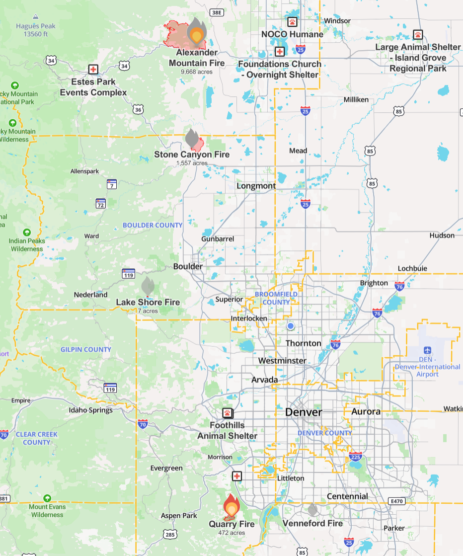
Source: WatchDuty App
Heatwave continues through Wednesday
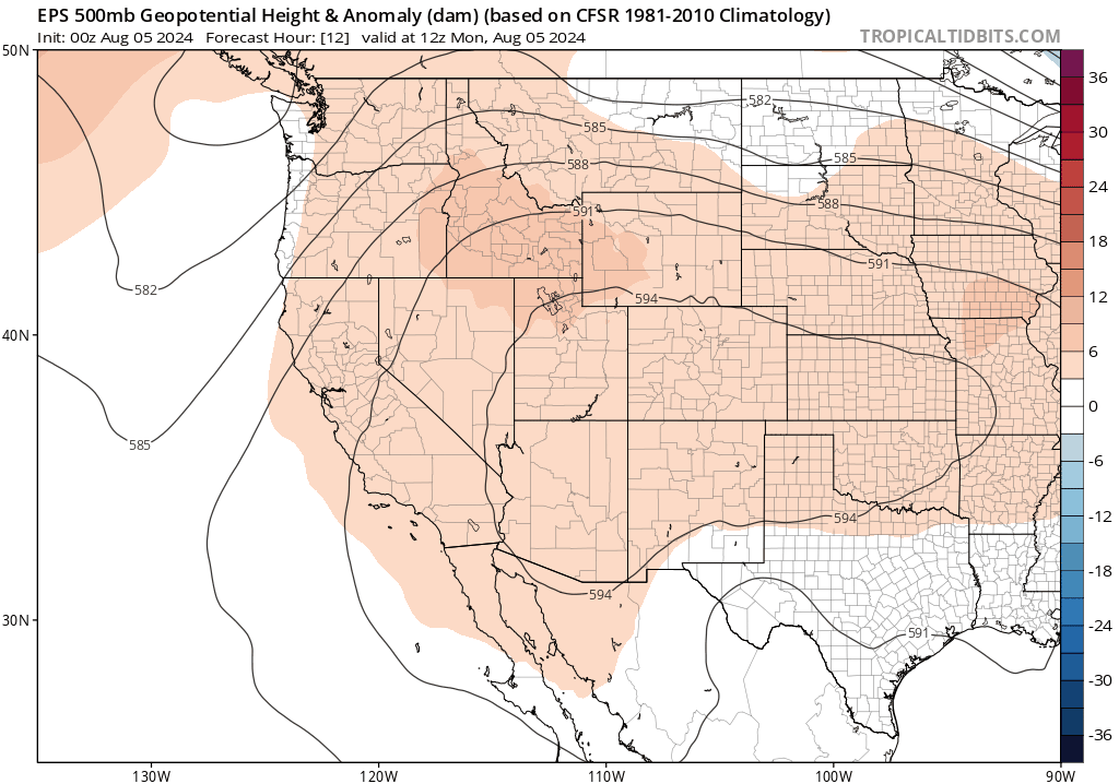
The stagnant, upper-level high pressure pattern responsible for the ongoing heatwave will hold across Colorado for the first half of the week ahead with a continuation of hot conditions in the Front Range for a few more days. The high pressure will be centered across southern Colorado on Monday. However, as the week progresses, the ridge will flatten out and wobble further south into Arizona and New Mexico. This shift is very subtly visible in the European ensemble 500mb height anomaly forecast below. As the ridge flattens out, a weak trough will scoot across the Upper Midwest and Great Lakes, with a cold front tied to this trough reaching eastern Colorado. This front will offer at least a short reprieve from the heat here later in the week.
Let’s not get too far ahead of things, though — we still have several blistering days to go before any potential cooldown reaches our area. Denver set a new daily record high on Sunday soaring to 102°, tying its hottest reading in 2024. Temperatures will be somewhat cooler the next few days, but not by much.
🌶️ Denver's 6th 100+ degree day of 2024 is a new record high for August 4th. Haven't hit 100 degrees in Boulder since 7/19/2022, more than two years ago. #COWx #Boulderwx #Boulder #Denver https://t.co/pB42cazJ2Q
— BoulderCAST Weather 🏔️❄️ (@BoulderCAST) August 4, 2024
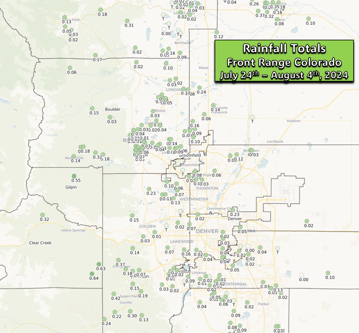
In addition to the heat, it’s been very dry during the current scorching stretch as well. Just 0.01″ of rain has fallen in both Boulder and Denver since the heatwave began back on July 24th. Some places in the Front Range have been a tad luckier, but for the most part, just a few hundredths of an inch of rain have accumulated over the last two weeks in our neck of the woods:
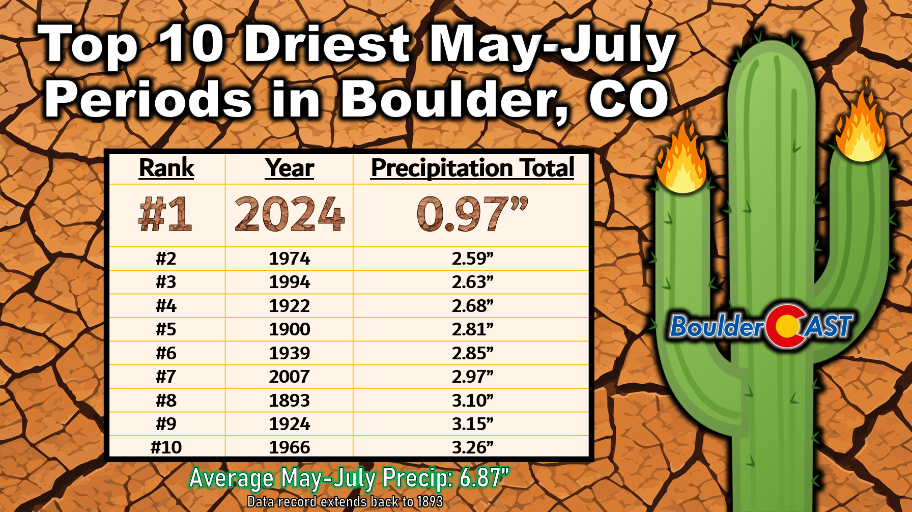
We’ve also now finished off yet another bone dry month solidifying the May-June-July period of 2024 as the all-time driest in Boulder since the last 1800s. Even worse, this new record three-month precipitation low was set by an exceptional margin, with just 0.97″ of rain falling since late April compared to normal which is close to 7 inches! The previous record low was back in 1974 when 2.59″ of rain fell — nearly triple what we received this year!
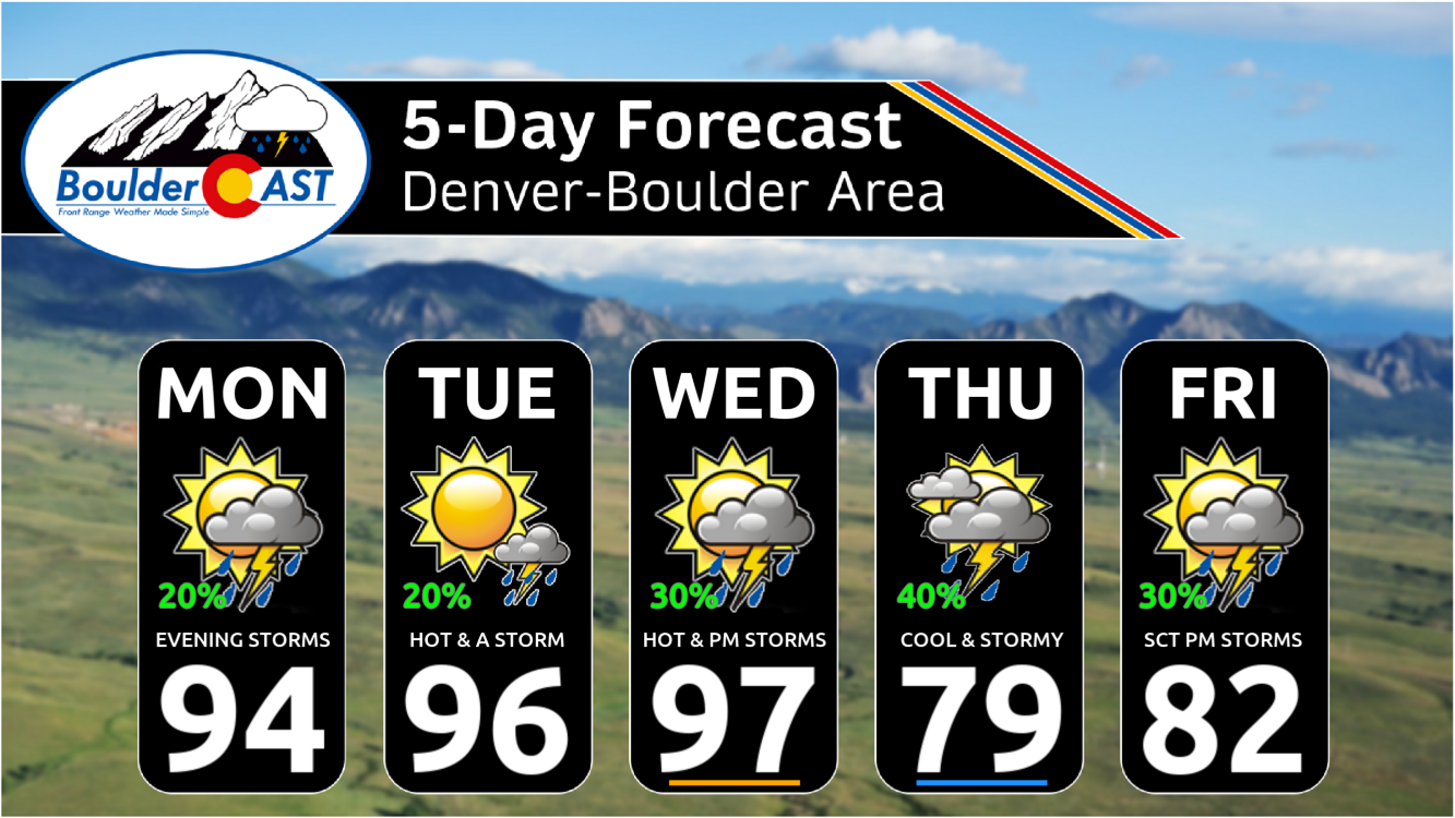
Looking ahead, Monday will be the 10th consecutive 90°+ day in Boulder and the 13th in Denver — basically a rinse-and-repeat forecast from what we’ve endured the last week or more. Morning sunshine will give way to afternoon storm clouds, but not before reaching the lower to middle 90s in most locations.
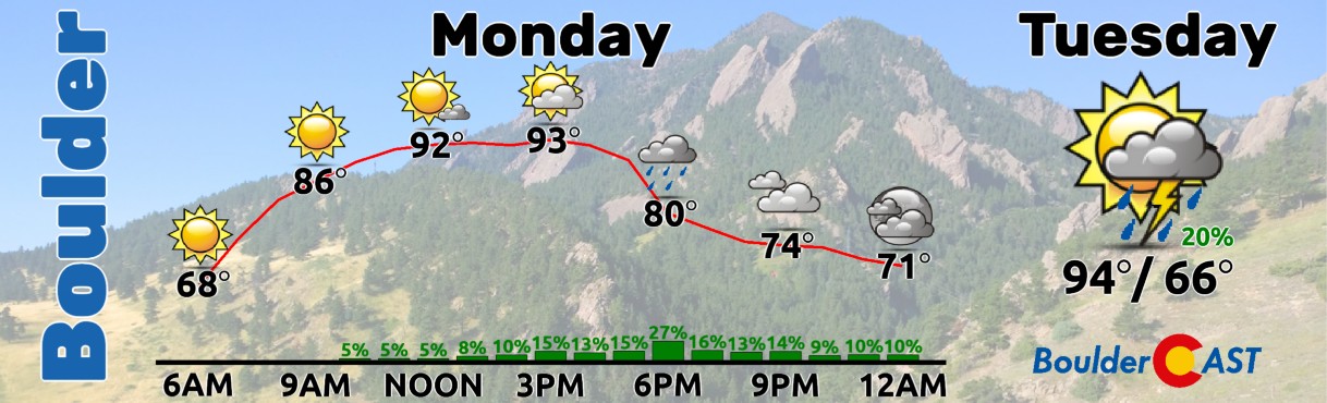
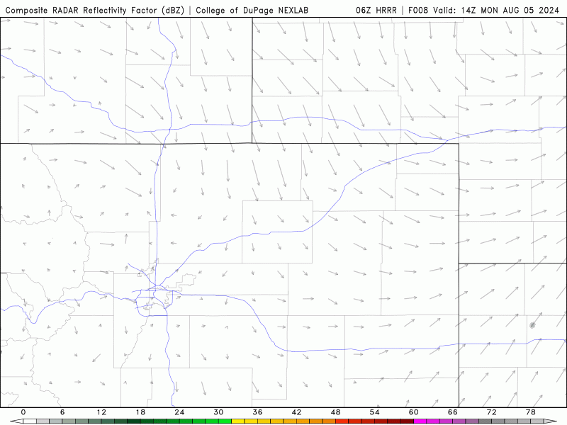
The chance of rain is about 20% on Monday, with raindrops potentially falling any time during the afternoon or evening. The HRRR model simulated radar animation below paints our area with isolated to widely scattered weak thunderstorms, mainly from 3PM to Midnight. The lower atmosphere remains dry, with an inverted-V profile noted across the lower elevations. Thus, Monday’s storms will be capable of wind gusts up to 50 MPH but only generally light rain. Tuesday will offer a similar chance of rain (20%) as temperatures creep up another couple degrees with mid to upper 90s in the Denver Metro area.
Fortunately we have seen smoke drastically decline in the Metro area the last few days, a result of active local fires slowing down and running out of fuel with containment, and the smoke from out of state mixing away. As of Monday morning, PM2.5 was very low across the Denver Metro area!
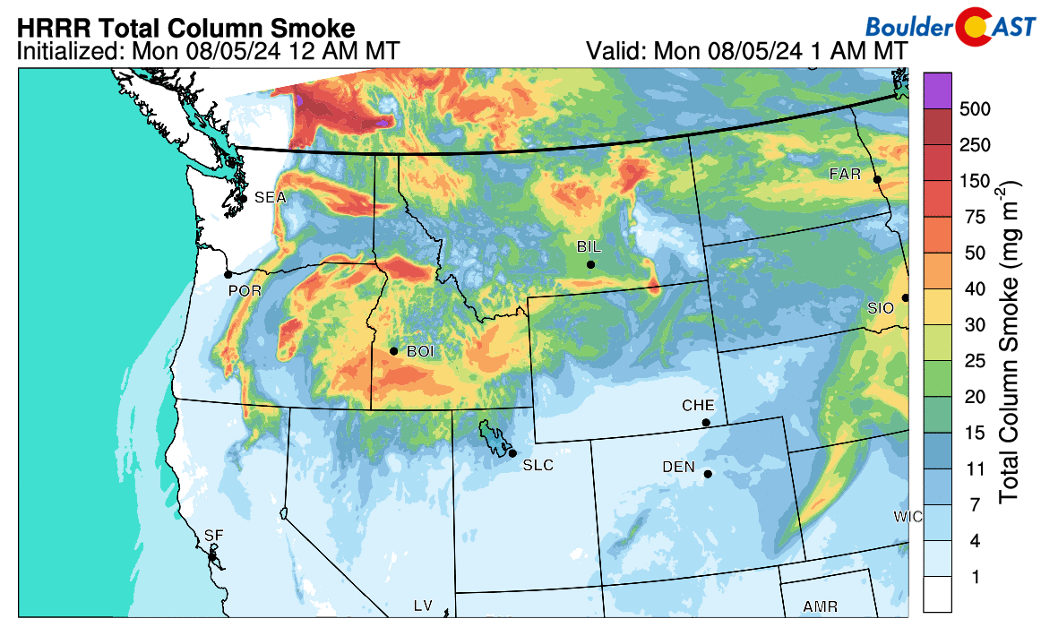
More good news: most of the smoke from fires burning in the Pacific Northwest will continue to shoot past us to the north, as shown in the animation below valid through Tuesday night. However, an increase in smoke is expected later in the week behind the aforementioned cold front. The smoke should not be particularly thick later this week, but some haze will return.
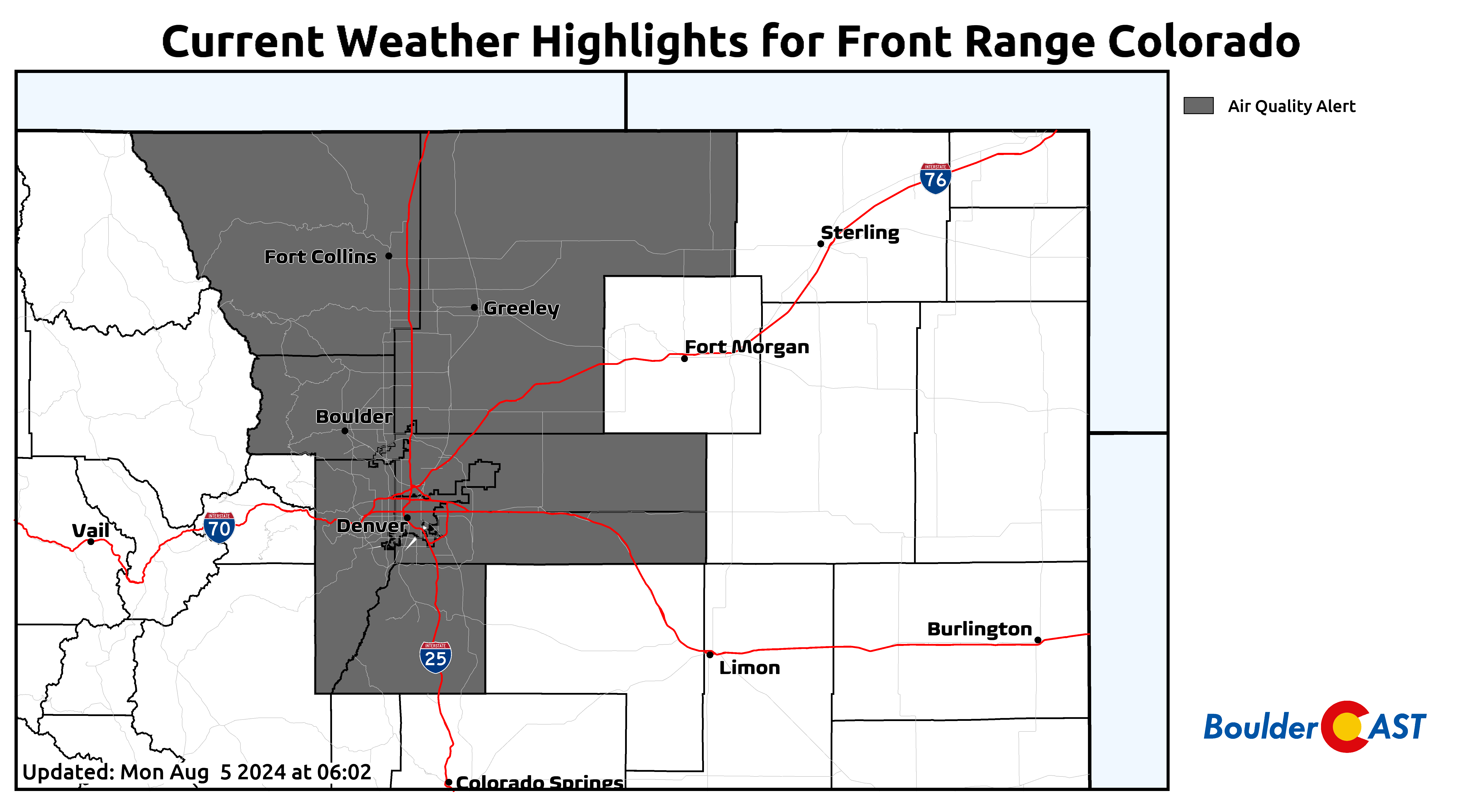
Of course, it’s summertime in Denver and the sky’s still blue, so that means ozone will continue to be a problem this week. Air Quality Alerts will remain in effect through at least Tuesday afternoon, if not longer. These are strictly for ozone, and not smoke.
Wednesday should be the last hot day of the week! Temperatures will once again top out in the mid to upper 90s with widely scattered late-day storms (20-30%). Wednesday evening is the current timeline for when we expect the cold front to arrive from the northeast tied to a low pressure system near the Great Lakes.
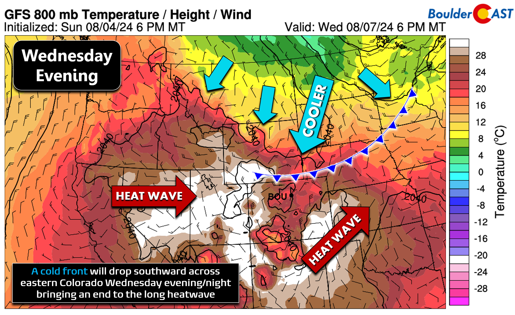
Upslope flow will usher in a surge of low-level moisture behind the cold front. Thursday will be cloudier and much cooler, with highs only in the 70s. Depending on how extensive low clouds are, we should see our best chance of rain for the week Thursday with scattered to numerous showers and storms developing throughout the day fueled by the uptick in moisture region-wide. Some storms could be severe on Thursday, though the Palmer Divide (and eastward) looks more at risk than Boulder or Denver.
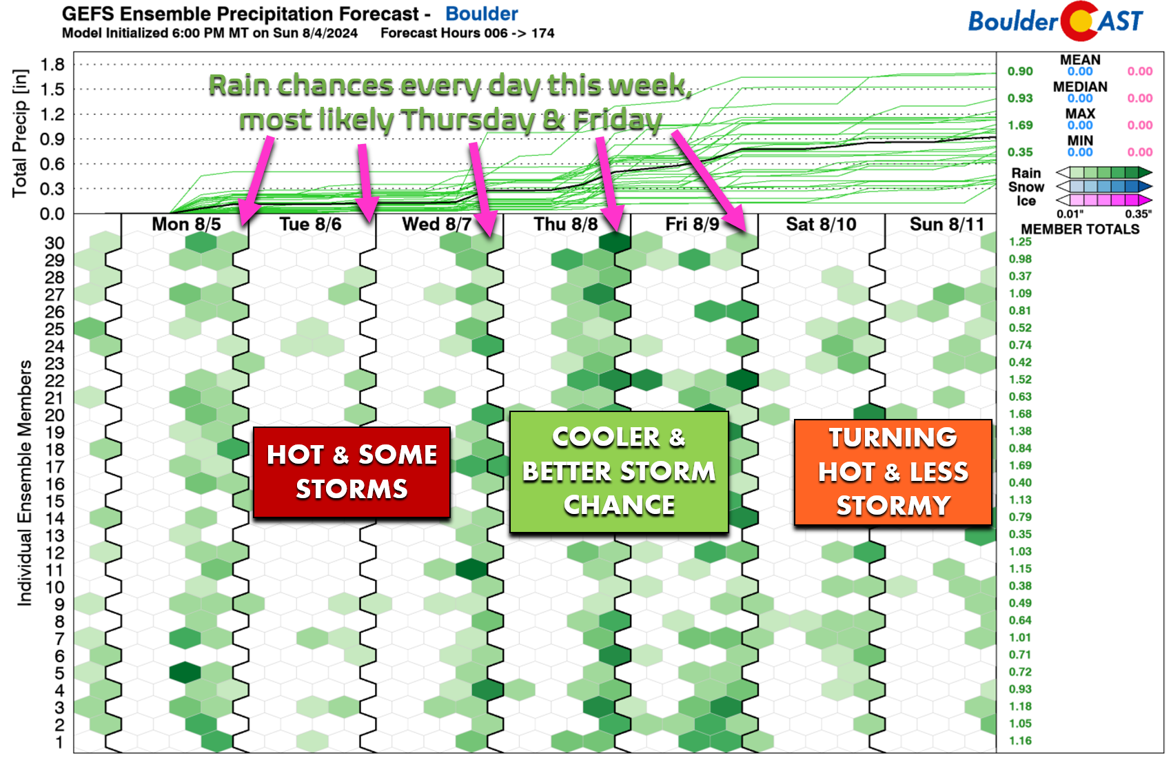
Temperatures should rebound slightly by Friday back into the lower 80s, but four days out, this could shift slightly up or down. Scattered storms look to remain in the forecast to end the work week.
It’s nice to see our extended forecast riddled with rainfall, but nothing looks too soaking at this point — and soaking rain is what we really need more than anything. Hopefully most areas can pick up one or two decent storms this week — we’d consider that a win given the pattern lacks significant monsoon moisture. Please don’t let your guard down regarding wildfires. Conditions early this week will be almost identical to early last week when so many fires started and took off.
As we move into the upcoming weekend, the high pressure center across the Southwest is expected to grow stronger once again with a slow warming and drying trend for our area. Temperatures will return to near 90 degrees Saturday and Sunday with a continued though lesser threat of late-day storms.
The tropics are heating up
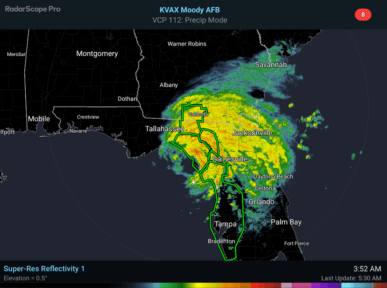
Finally, we just wanted to briefly touch on the tropics as Category 1 Hurricane Debby is making landfall in Florida early Monday morning. Heavy rain, a few tornadoes, moderate storm surge, and up to 80 MPH sustained winds are impacting parts of the Sunshine State right now. Debby is expected to emerge later today over the Atlantic and then linger in some form across the Carolinas early this week with flooding rains the main concern with this slow-moving storm.
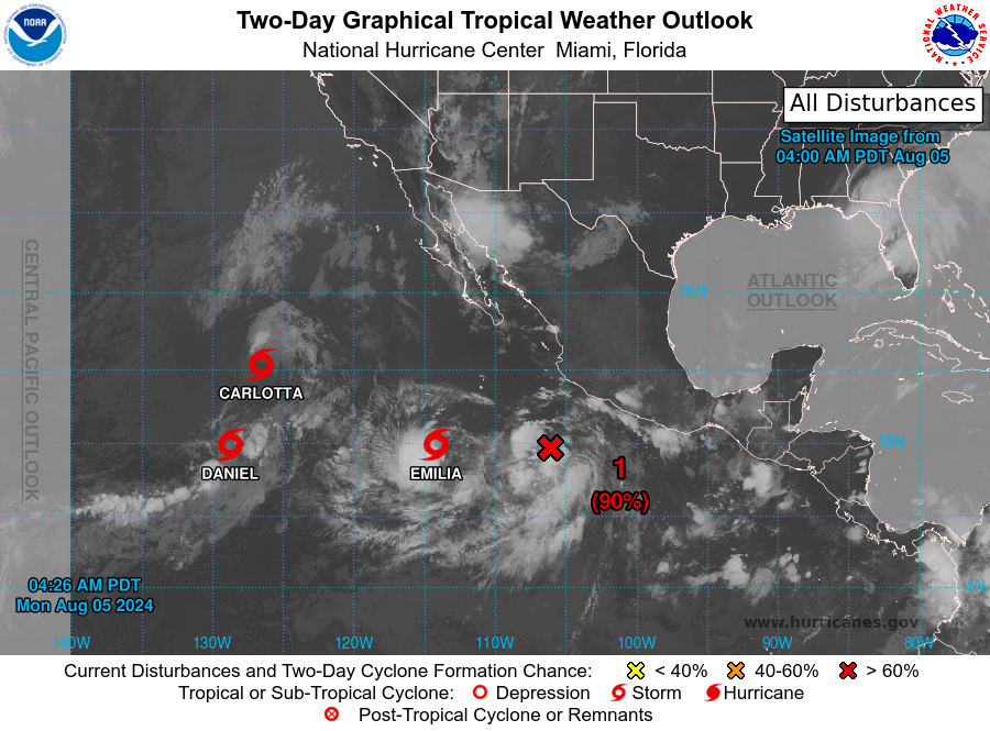
The Eastern Pacific Basin has been eerily quiet most of the summer so far, something we expected given the developing La Niña conditions. However, the tranquility has been interrupted of late with now three named Tropical Storms out over open water — Carlotta, Daniel, and Emilia, with a fourth storm likely to be named later on Monday. All three storms are very weak and pose no threat to land. As discussed previously, big hurricanes off the western coast of Mexico can sometimes help enhance monsoonal flow into the southwestern United States. There’s no signs of that happening anytime soon, though. Color us disappointed!
Have a great week!
Forecast Specifics:
Monday: Morning sunshine will give way to afternoon clouds with widely scattered evening storms. Storms could produce gusty winds up to 50 MPH but generally light rainfall. Highs reach the low to middle 90s on the Plains with near 80 in the Foothills.
Tuesday: Mostly sunny with widely scattered late-day storms. High temperatures in the middle to upper 90s across the Plains with lower 80s in the Foothills. Storms may produce gusty winds up to 45 MPH.
Wednesday: Likely the hottest day of the week with highs in the mid to upper 90s on the Plains. Scattered late-day storms will unfold as a cold front approaches. Elevated to near-critical fire danger may occur in the Foothills.
Thursday: Much cooler with possibly some morning low clouds. Then partly to mostly cloudy with scattered to numerous showers and storms developing. Some storms may turn severe south and southeast of Denver. Highs reach only the upper 70s on the Plains with lower 70s in the Foothills. Smoke from Canada and the Pacific Northwest may increase somewhat but nothing too bad.
Friday: Staying cooler with scattered late-day storms. Highs reach the lower 80s on the Plains with lower 70s in the Foothills.
Weekend: Temperatures return to near or slightly above normal back to around 90 degrees with a slight chance of late-day storms both days.
Get BoulderCAST updates delivered to your inbox:
DISCLAIMER: This weekly outlook forecast is created Monday morning and covers the entire upcoming week. Accuracy will decrease as the week progresses as this post is NOT updated. To receive daily updated forecasts from our team, among many other perks, subscribe to BoulderCAST Premium.
Go Premium, get all the perks.
Daily Forecast Updates
Get our daily forecast discussion every morning delivered to your inbox.
All Our Model Data
Access to all our Colorado-centric high-resolution weather model graphics. Seriously — every one!
Ski & Hiking Forecasts
6-day forecasts for all the Colorado ski resorts, plus more than 120 hiking trails, including every 14er.
Smoke Forecasts
Wildfire smoke concentration predictions up to 72 hours into the future.
Exclusive Content
Weekend outlooks every Thursday, bonus storm updates, historical data and much more!
No Advertisements
Enjoy ad-free viewing on the entire site.
Enjoy our content? Give it a share!


Excellent forecast. As usual, great information and detailed info, if not slightly depressing – but those are the conditions we have this summer.
The snarky and derisive comment about “local conspiracy theorists” needs to be checked. I witnessed an attempted arson case in my neighborhood last week, which was termed as such by the firefighters who arrived at the scene. The quarry Fire is now being investigated as arson. And all the while, an accused arsonist from earlier in July was still at large. Boulderites had good reason to be concerned. No one is trying to divert attention away from how dire the conditions are – if anything, it’s BECAUSE of these conditions that people are on edge.
Very disappointed to read something so dismissive.
Not fully dismissing the arsonists claims, but…
Just because so many fires started so quickly, many people immediately jumped to arson as the cause, when in reality, our area is so dry and now overpopulated with some percentage of careless people, accidents were always the more likely cause. Some of the fires even ignited too close temporally for it to be have been the same arsonist.
No need to jump to conclusions on the cause. Let the investigators arrive there if evidence supports it. We don’t need to encourage other would-be arsonists to realize they could do a whole lot of destruction to the Front Range with minimal effort and a very low chance of being caught. Why shoot up Walmart and risk death yourself when you can just throw a couple lit cigarettes out the window while casually driving along Peak to Peak Highway on a breezy day?