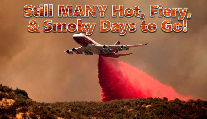
Between the extreme heat, thick smoke and new wildfire ignitions, this week has been quite the disaster in the Front Range! Our fuels have been primed for weeks now and our team has been vocal regarding this inevitable outcome, but things unravelled much quicker than even we expected this week with something like ten wildland fires in the Front Range just since Monday, in total burning more than 9,000 acres of forest! The weekend unfortunately won’t offer much reprieve from the heat, fire or drought, but we are tracking a potential shift next week towards wetter and cooler conditions. We provide an update on the local fires, the ongoing heatwave, the widespread smoke, and when actual raindrops may return to the forecast.
Key Highlights from This Post:
- Heatwave Continues and Even Intensifies: The weather pattern will continue to support very hot and dry weather in the Front Range throughout the extended with temperatures 95° or better every day.
- Local Wildfires Remain Active: Existing fires will continue to grow slowly as hot/dry weather persists, and new fires remain a real concern. Light winds should at least keep the fires manageable.
- Smoke Sticks Around: Between the nearby fires and big fires out of state, moderate to locally heavy smoke will remain through at least Saturday morning in the Front Range. Air quality will be an issue.
- Mother Nature May Start New Fires: Moisture will remain below normal through the weekend, but some storms are expected to form. Minimal rain and lightning may produce new fire ignitions Friday, Saturday or Sunday. This would be in addition to any new fires started by idiots.
- Cooling Trend & Rain Chances Next Week: Our heatwave will come to an end around Tuesday or Wednesday of next week with rain chances on the rise as well.
Help support our team of Front Range weather bloggers by joining BoulderCAST Premium. We talk Boulder and Denver weather every single day. Sign up now to get access to our daily forecast discussions each morning, complete six-day skiing and hiking forecasts powered by machine learning, first-class access to all our Colorado-centric high-resolution weather graphics, bonus storm updates and much more! Or not, we just appreciate your readership!

More of the same: Hot, dry & smoky
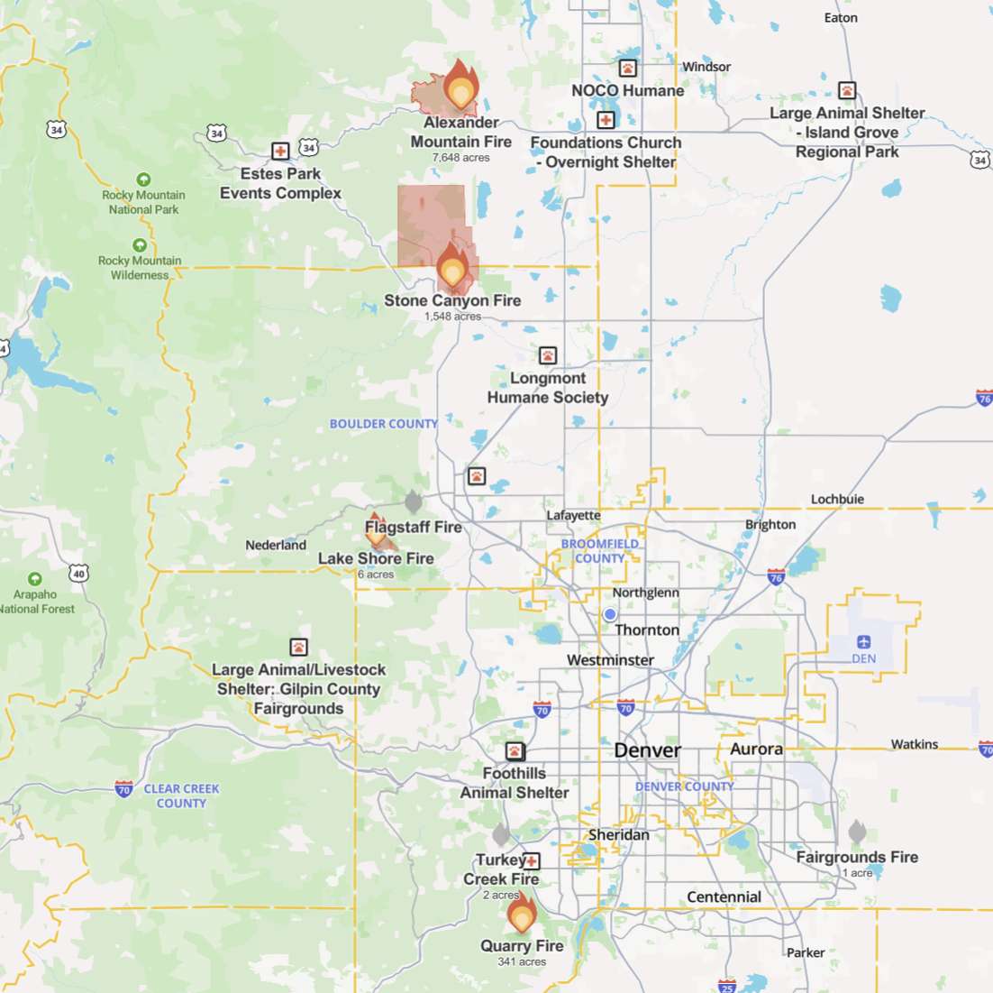
It’s hard to keep up with the amount of fires starting the Front Range anymore. There were a few small ones in the last 24 hours which have already been entirely put out, including one near Morrison, one on the side of Flagstaff Mountain in Boulder, and another at the Arapahoe County Fairgrounds. The most significant fire to start during the day Wednesday was the Lake Shore Fire west of Boulder near Gross Reservoir, currently at 6 acres in size and 0% containment. Hopefully the can get the one under control today. The other, bigger fires remain a real concern as well, especially the Alexander Mountain Fire near Loveland which is pushing towards 8000 acres but somehow is yet to consume any structures.
Source: WatchDuty
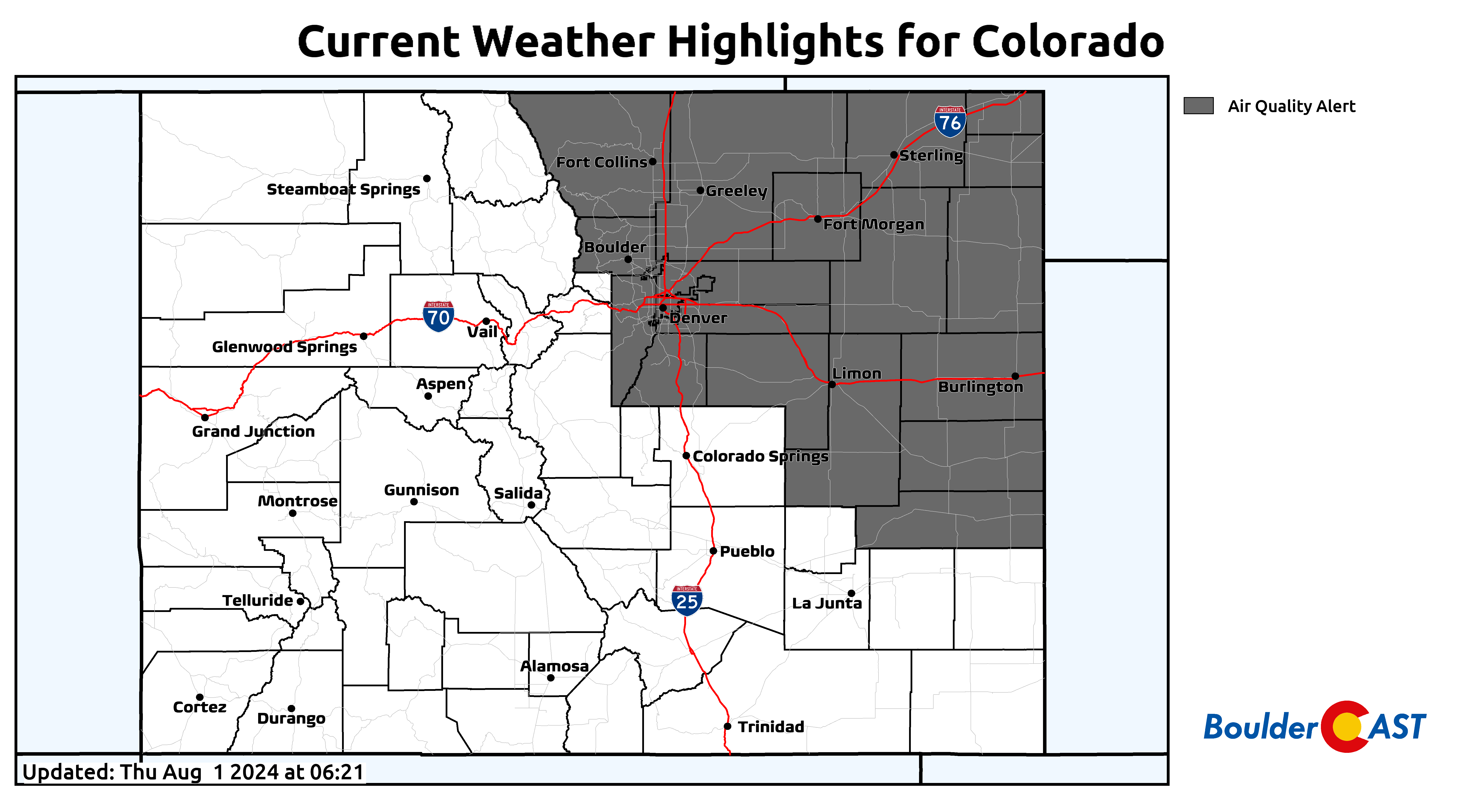
An Air Quality Alert remains in effect for Thursday and Friday for smoke and ozone for all of northeast Colorado.
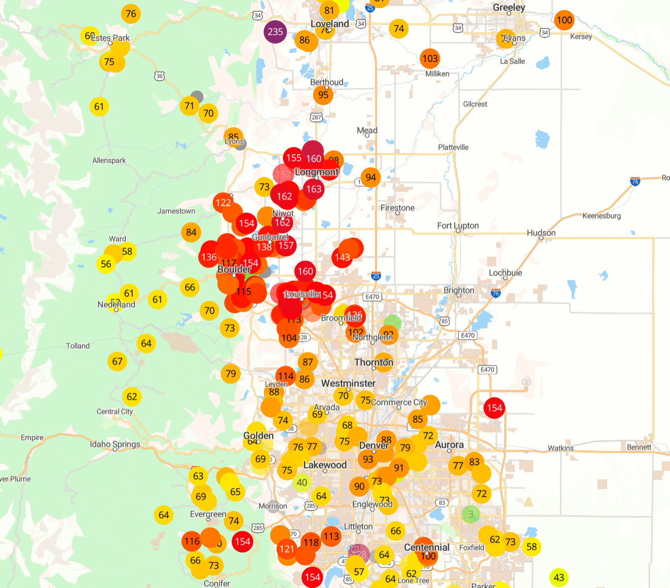
As of sunrise Thursday, PM2.5 was at Moderate levels for most of the Front Range, except for those directly downwind of local fire plumes which were worse. Parts of Boulder, Longmont, Louisville, and Littleton have Unhealthy for Everyone air this morning due to low-lying smoke.
Source: PurpleAir
Ozone levels have come down considerably overnight, as typical, but they were quite nasty yesterday and will be again later Thursday afternoon. Between the smoke and the ozone (and the roasting temperatures), outdoor activities should be limited somewhat during the heat of the day.
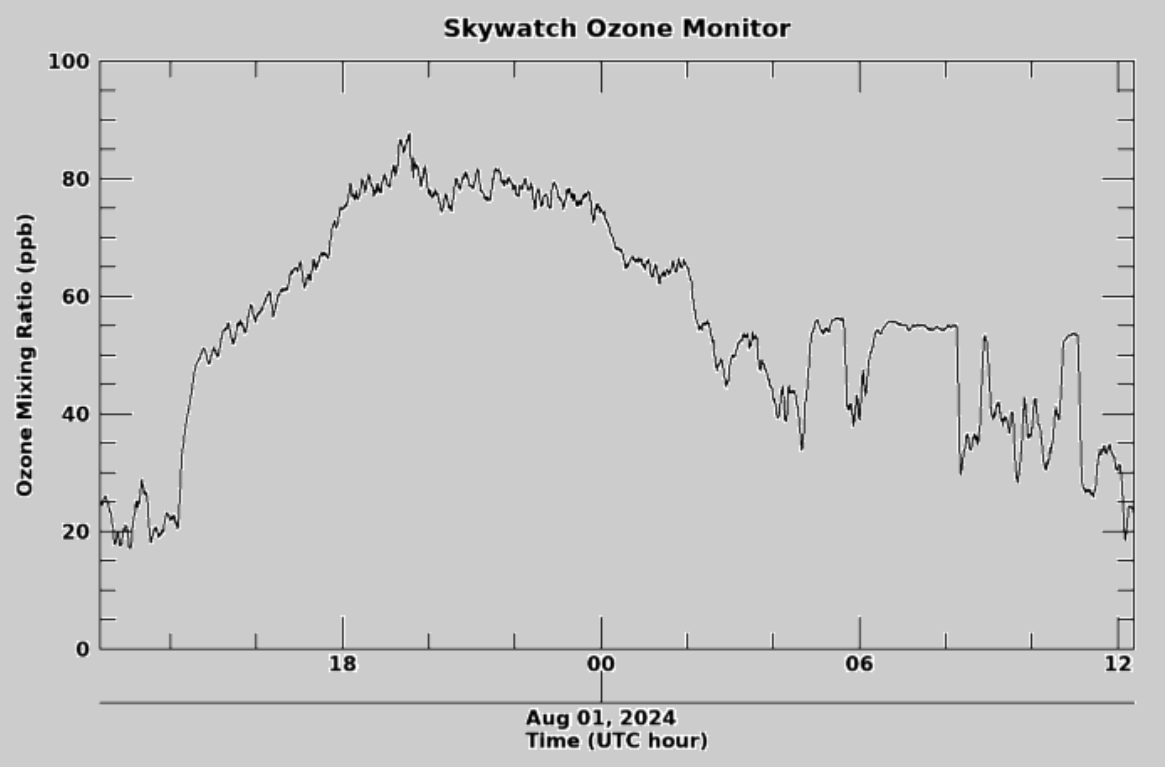
Source: CU Boulder Skywatch Observatory
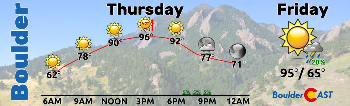
Thursday’s forecast will be more of the same with hot conditions, mostly sunny skies, low humidity, light winds and thick haze from the smoke. High temperatures will land between 95 and 99°F today across the lower elevations, with 80s to lower 90s in the higher terrain. The record high temperature for August 1st in Boulder is 100°F set back in 1938 and that should remain intact. Some convective models do try to form a few weak showers or storms this evening, but anything that develops should remain south of Denver, mainly over the Palmer Divide area.
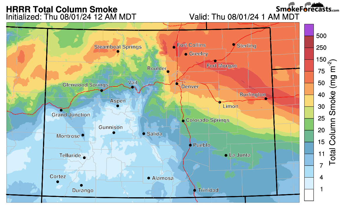
Smoke is expected to remain locked in across the Denver Metro area through at least Saturday morning. We may start to see things clear out this weekend, but some amount of haze is likely to persist into next week, especially if our local fires continue to eat through forest. Follow the latest movement of the smoke on our Colorado Smoke Forecast page.
Looking ahead, the outlook for the next five days remains more of the same as our pattern changes very little during this timeframe. The center of high pressure in Texas will shift westward, reforming and intensifying near the Four Corners in the coming days. This will put Colorado directly under a dominant ridge of high pressure which will put a lid on our rainfall chances in through Saturday, with very little hope to see measurable rainfall during this time while our heatwave rages on.
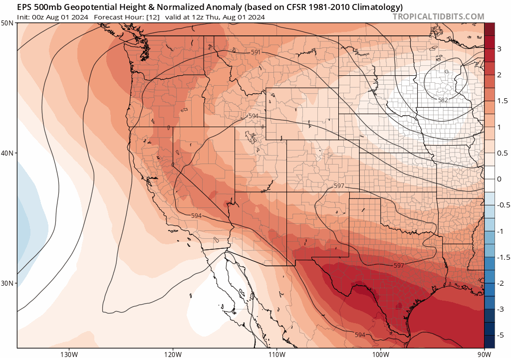
Fortunately this ridge will keep winds light across our area through at least Sunday which should help with firefighting efforts. Though the same ridge will also be responsible for near-record heat and bone dry humidities, two things that contribute to growing fires. There’s really no winning right now in the heart of fire season with fuels this dry!
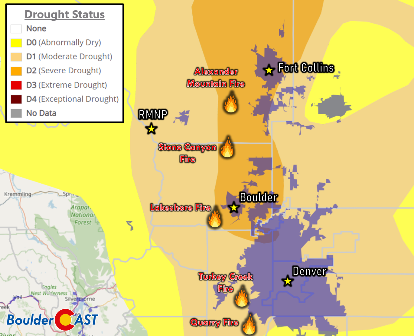
Source: US Drought Monitor & BoulderCAST
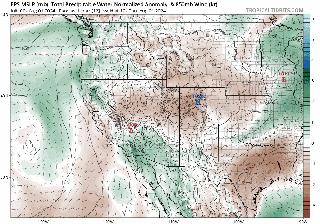
A decent amount of monsoon moisture will get pulled northward on the western side of the developing ridge, eventually rotating around clockwise and into our area by late in the weekend and early next week. This monsoonal plume is well-advertised in the European ensemble moisture anomaly forecast below, arriving into the Denver area late Sunday or Sunday night.
Actual rainfall chances will return to our forecast Sunday and beyond when this moisture pulls into station. Nothing looks too crazy at this early juncture, but widely scattered to scattered storms are expected with moderate to locally heavy rainfall up for grabs. The small amount of storms that dot the extended will offer little in the way of rainfall, but could produce cloud-to-ground lightning capable of spawning new fires. This will need to be watched closely Friday, Saturday and Sunday, especially in the Foothills and Mountains where new fire ignitions would be more challenging to reach quickly.
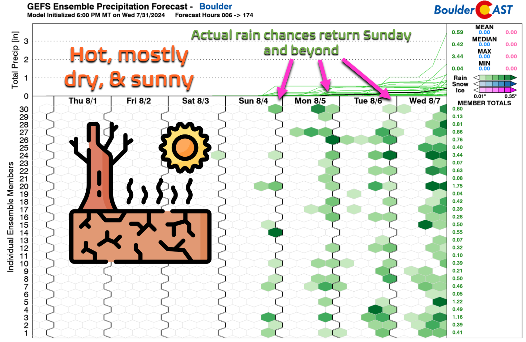
Temperatures will remain in the mid to upper 90s throughout our extended, perhaps making a run towards 100° on Sunday in many areas. As mentioned, rain will be very hard to come by until late Sunday and the days to follow.
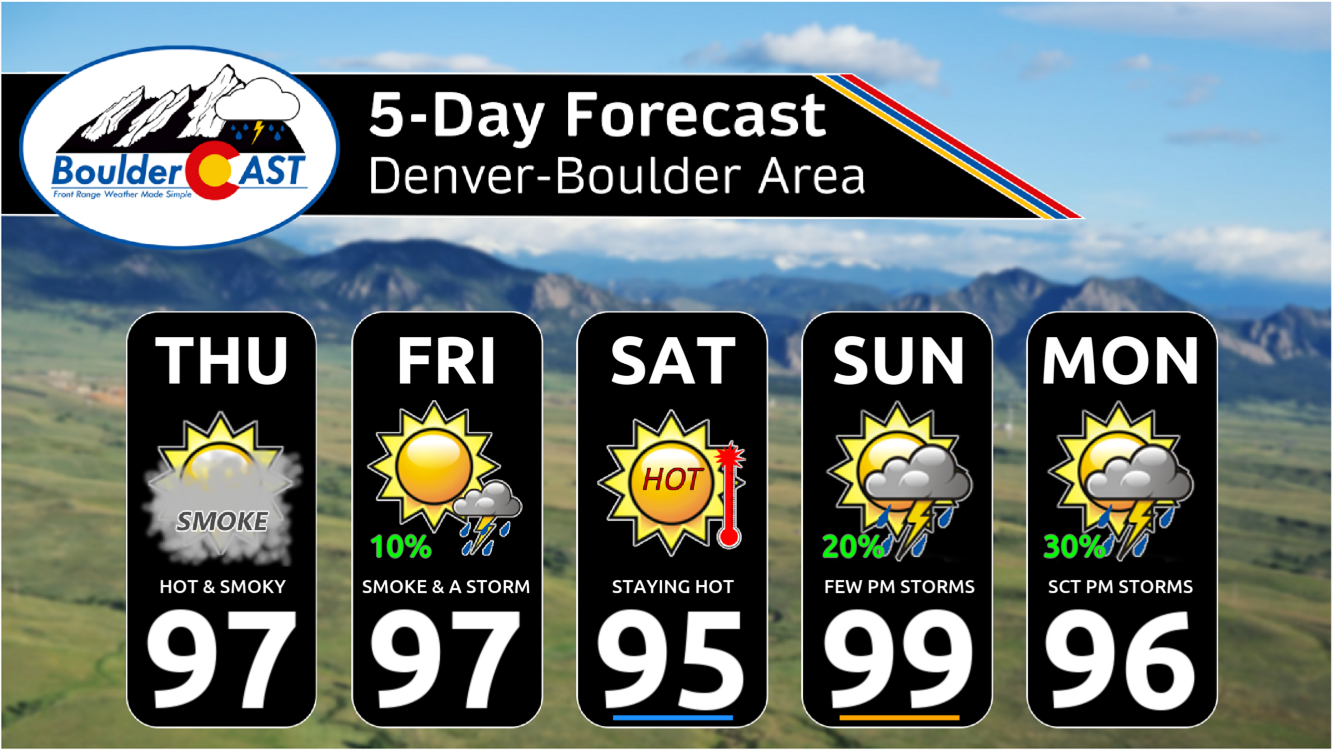
We’re already tracking a pattern shift next week which will see the ridge slide further west allowing more significant cold fronts to reach the Front Range from the northeast. One or two cold fronts are set to arrive around Tuesday or Wednesday of next week. This should bring an end to the ongoing heatwave with temperatures falling back into the 80s, with 70s not out of the question either. The Climate Prediction Center is forecasting near normal temperatures and above normal precipitation for our area by mid to late next week — just what the firefighters needed. Finally, a light at the end of the tunnel perhaps! This cooler airmass could come infused with Canadian smoke again, but that remains to be seen…
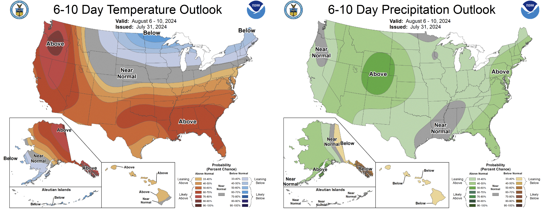
Source: NOAA Climate Prediction Center
That’s all for now. Be smart this weekend. Don’t push yourself too much in the heat and please don’t be responsible for our next wildfire!

Stay up to date with Colorado weather and get notified of our latest forecasts and storm updates:
We respect your privacy. You can unsubscribe at any time.

Go Premium, get all the perks.
Daily Forecast Updates
Get our daily forecast discussion every morning delivered to your inbox.
All Our Model Data
Access to all our Colorado-centric high-resolution weather model graphics. Seriously — every one!
Ski & Hiking Forecasts
6-day forecasts for all the Colorado ski resorts, plus more than 120 hiking trails, including every 14er.
Smoke Forecasts
Wildfire smoke concentration predictions up to 72 hours into the future.
Exclusive Content
Weekend outlooks every Thursday, bonus storm updates, historical data and much more!
No Advertisements
Enjoy ad-free viewing on the entire site.
Enjoy our content? Give it a share!


You must be logged in to post a comment.